Report to/Rapport au :
Agriculture and Rural Affairs Committee
Comité d'agriculture et des questions rurales
and Council / et au Conseil
25 June 2008 / le 25
juin 2008
Submitted by/Soumis par : Nancy Schepers, Deputy City Manager /
Directrice municipale adjointe,
Planning, Transit and the Environment /
Urbanisme, Transport en commun et Environnement
Contact Person/Personne ressource : Karen Currie,
Manager / Gestionnaire, Development Approvals / Approbation des demandes
d'aménagement
(613) 580-2424, 28310 Karen.Currie@ottawa.ca
|
SUBJECT: |
|
|
|
|
|
OBJET : |
REPORT RECOMMENDATIONS
That the Agriculture and Rural
Affairs Committee recommend Council:
1.
Refuse an amendment to the former Township of Osgoode
Zoning By-law, to change the zoning of Part of 1149 Yorks Corners Road from
Rural (RU) to Residential (R), as shown in Document 1.
2.
Refuse an amendment to the New Comprehensive Zoning
By-law to change the zoning of Part of 1149 Yorks Corners Road from Agriculture
Zone 3 (AG3) to Rural Residential 8 (RR8), as shown in Document 1.
RECOMMANDATIONS DU
RAPPORT
Que le Comité de l'agriculture et des affaires rurales recommande au Conseil :
1.
de
refuser une modification au Règlement municipal de l’ancien Canton d’Osgoode
visant à changer le zonage d’une partie de la propriété située au 1149, chemin
Yorks Corners, de Zone rurale (RU) à Zone résidentielle (R), comme le montre le
document 1.
2.
de
refuser une modification au nouveau Règlement de zonage général visant à
changer le zonage d’une partie de la propriété située au 1149, chemin Yorks
Corners de Zone agricole 3 (AG3) à Zone résidentielle rurale 8 (RR8), comme le
montre le document 1.
BACKGROUND
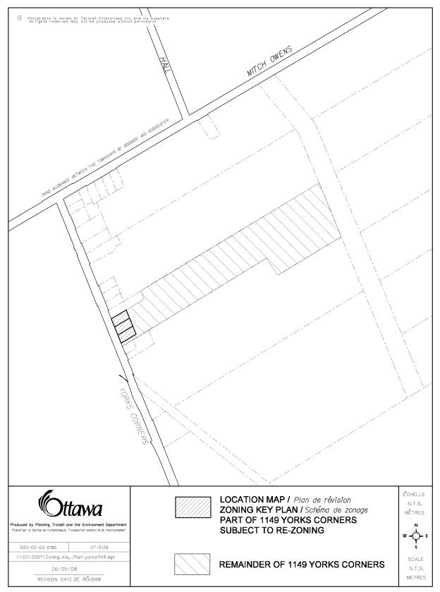
The purpose of the subject application is to amend
to the former Township of Osgoode Zoning By-law to change the zoning on a part
of 1149 Yorks Corners Road. The
property is 16.8 hectares in area and the part subject to rezoning is
approximately 0.53 hectares in area.
The site is situated on the east side of Yorks Corners Road, south of
Mitch Owens Road. The site is
vacant and is situated directly east of the hamlet of Edwards. Rural residential lots exist to the west,
north, and south of the site. Vacant
lands zoned Rural exist to the east of the subject land.
The property is zoned Rural (RU) under the former
Township of Osgoode Zoning By-law.
Purpose of Zoning Amendment
The applicant is seeking to rezone part of 1149
Yorks Corners Road to permit three privately‑serviced residential lots
having a minimum area of 1776 square metres and 30 metres of frontage. The closest zone within the former Township
of Osgoode Zoning By-law that matches the applicant’s request is “Residential
(R)” which permits a residential use on minimum lot area size of 1393.5 square
metres and with a minimum lot frontage of 30.4 metres.
Under the former Township of Osgoode Zoning By-law
2003-230, the subject land is presently zoned “Rural (RU)”. The permitted main uses within a Rural Zone
are a single-detached dwelling, an agricultural use and a forestry use. This zone also permits an animal kennel and
other uses. The minimum lot area for
single detached dwelling is 10 hectares (25 acres). The minimum lot frontage allowed under the
By-law for a single detached dwelling is 182.8 metres.
The new Comprehensive Zoning
By-law has the subject land zoned Agriculture Zone 3 (AG3). This zone has similar permitted uses and
standards as those of the aforementioned Rural Zone. The only difference between this zone and the Rural zone is the
lot frontage as the requirement under AG3 is 60 metres.
It is anticipated that the new Comprehensive Zoning
By-law will be passed by City Council on June 25, 2008. In the new by-law, a zone that will permit a
residential use on a lot that is approximately 1756 square metres with 30 metres
of frontage is Rural Residential Zone 8 (RR8).
The minimum lot area and frontage permitted for RR8 is 1600 square
metres and 30 metres, respectively.
DISCUSSION
Provincial Policy Statement
The subject land is within a prime agricultural area. In prime agricultural areas permitted uses and activities are limited to agricultural uses and agriculture-related uses.
Agriculture-related uses are those that are farm-related commercial and farm-related industrial uses that are small in scale and directly related to the farm operation and are required in close proximity to the farm operation. Any proposed use shall be compatible with agriculture, and shall not hinder, surrounding agricultural operations.
Land can only be excluded from prime agricultural area for limited non-residential uses, provided that the land does not comprise a specialty crop area, there is a demonstrated need within the planning horizon for additional land to be designated to accommodate the proposed use, there are no reasonable alternative locations which avoid prime agricultural area.
The proposed use that is being considered under this Zoning By-law Amendment is not considered compatible with agriculture and cannot be considered an agricultural related use. It is a type of use that will impede surrounding agricultural operations when in proximity to farm operations. The proposed lots are not considered to be farm-related commercial or farm-related industrial. Moreover, the proposal further contravenes the Provincial Policy Statement, as there is no demonstrated need identified within the planning horizon for additional land to be designated to accommodate the proposed use and numerous reasonable alternative locations exist which avoid prime agricultural areas.
The Provincial Policy Statement does not support the creation of three residential uses within a prime agricultural area. Any residential development proposal should be redirected to lands designated Village or within the urban boundary’s residential zones where there is sufficient and adequate servicing capacity.
Official Plan
According to the Official Plan, the subject land is designated “Agricultural Resource Area”. The Official Plan recognizes the importance of protecting and preserving this vital resource from loss to other uses. It is intended to protect the major areas of agricultural production and other lands suitable for agriculture from loss to other uses. It also ensures that uses that would result in conflicts with agricultural operations are not established in productive farming areas. Residential severances are only permitted for very limited farm-related purposes. The creation of new non-farm residential lots is generally not permitted. As well, all new farm and non‑farm development, including severances, must comply with the Minimum Distance Separation formulae, as amended from time to time.
Within the Official Plan, the policies state that residential uses that would result in conflicts with agricultural operations are not to be established. Accordingly, all new farm and non-farm development, including severances, must comply with the Minimum Distance Separation (MDS) formulae. Data to calculate the MDS has not been submitted to date by the applicant.
The introduction of residential uses into an agricultural area may hinder the expansion of farm operations, by limiting the expansion or introduction of barns and manure storage facilities within the general vicinity. Land uses, other than an agricultural use, are to be strictly limited to uses directly related to agriculture and such agriculturally related uses.
Policies also exist to safeguard the integrity of groundwater resources, and as such, the City is to consider the potential for impact on groundwater resources. In this case, the part requested to be rezoned has been identified as lands that play a role in the management of the groundwater resource. In response, the applicant submitted a hydrogeological study for the City to assess the appropriateness of the proposed residential uses. The technical results from the hydrogeological study do not provide satisfactory confirmation that the part subject to the application is an appropriate location for three privately serviced residential uses.
The
policies of the Official Plan do not support the creation of three residential
parcels within a prime agricultural area.
In fact, even if the lands were designated General Rural, three
severances would not be permitted.
A dug well was constructed on the subject site; however, no quantity testing was performed. In the absence of quantity testing, it cannot be determined whether there will be a reliable supply of groundwater over the long-term. Also, based on the description provided for the dug well, there are significant concerns as to whether the well meets the requirements of Regulation 903 “Wells”, Ontario Water Resources Act. No professional certification has been provided on the compliance of the well with the regulation, as required pursuant to Osgoode By-law 37-98, which is still in effect, and a well record has also not been submitted.
Groundwater from the dug well was submitted for analysis, and bacteria were encountered. This is a cause for concern that has not been satisfactorily addressed. The safety of the groundwater is therefore questionable.
No plan showing the location of a house, a well and a sewage system for each proposed lot has been submitted as part of the hydrogeological and terrain analysis report and its revisions. This leaves sufficient doubt in Conservation Authority’s and the City’s mind as to whether or not a Zoning Amendment to permit three lots of 1776 square metres is appropriate.
The size of the proposed lots has yet to be substantiated. The Conservation Authority Hydrogeologist and City Staff are in agreement on the concerns noted herein.
Other Planning Issues
The proposed zoning presents another concern in that the lands that are
intended to remain in the Rural zone would be left with a frontage of only 11
metres. This frontage is located to the
south of the most southerly proposed lot identified in Document 1. Within this 11-metre corridor there is a
watercourse/municipal drain which further reduces the frontage on Yorks Corners
Road. A frontage of less than 11 metres
within the setback requirements from watercourses is not considered sufficient
for the functional development of a 16.2-hectare lot that is to remain zoned
Rural.
Summary
Staff do not support the proposed Zoning By-law amendment as it contravenes the Provincial Policy Statement and does not comply with the policies of the Official Plan.
The rezoning the subject lands will result in the residual lands having insufficient frontage to meet the Rural zoning provisions. The frontage requirement under the Rural zone is 182.8 metres, whereas the residual frontage will be approximately 11 metres. The hydrogeological study submitted with this amendment proposal also does not provide conclusive evidence that there is sufficient water quantity or quality for three residential lots that are approximately 1776 square metres each.
ENVIRONMENTAL IMPLICATIONS
The introduction of three residential uses into this area may adversely affect the groundwater quality and quantity.
RURAL IMPLICATIONS
The proposed Zoning By-law amendment introduces residential uses into an
area protected for agricultural and agriculturally-related uses. By permitting residential uses, a major
agricultural area will become fragmented.
The introduction of residential uses into an agricultural area will
hinder the expansion of farm operations, by limiting the expansion or
introduction of barns and manure storage facilities.
CONSULTATION
Notice of this application was carried out in accordance with the City's Public Notification and Consultation Policy. The Ward Councillor is aware of this application and the staff recommendation. The City received one objection from the public to this application. The neighbour was opposed to this proposal on the basis that:
- The proposed development is not in keeping with the lotting fabric (size and frontage) of the Edward hamlet’s large single family lots.
- There is a water quantity problem that exists within the area and shallow dug wells do not provide enough water in the summer months for existing lots of record.
- There is a water quality issue within the area and water is usually bacteria-laden for existing lots of record.
- Three more septic systems in close proximity to each
other and to existing lots of record gives rise to the possibility of
contamination for existing wells within the general area.
FINANCIAL IMPLICATIONS
APPLICATION PROCESS TIMELINE STATUS
The application was not processed by the "On Time Decision Date" established for the processing of Zoning By-law amendments due to the complexity of the issues associated with hydrogeology.
SUPPORTING DOCUMENTATION
Document 1 Location Map
DISPOSITION
City Clerk’s Branch, Council and Committee Services to notify the owner, 1534058 Ontario Inc., c/o. Martin and Anna Schouten, 6139 Malakoff Road, Richmond ON K0A 2Z0, applicant, Adrian Schouten, 6133 Malakoff Riad, Richmond, ON K0A 2Z0, OttawaScene.com, 174 Colonnade Road, Unit #33, Ottawa, ON K2E 7J5, Ghislain Lamarche, Program Manager, Assessment, Financial Services Branch (Mail Code: 26-76) of City Council’s decision.
Planning, Transit and the Environment Department to prepare the implementing by-law, forward to Legal Services Branch and undertake the statutory notification.
Legal Services Branch to forward the implementing by-law to City Council.
LOCATION MAP DOCUMENT 1