Report to/Rapport au :
Planning and Environment Committee
Comité de l'urbanisme et de
l'environnement
and Council / et au Conseil
27 June 2005 / le 27 juin 2005
Submitted by/Soumis par : Ned Lathrop, Deputy City Manager/Directeur municipal adjoint,
Planning and Growth Management / Urbanisme et Gestion de la croissance
Contact Person/Personne
ressource : Grant Lindsay, Manager / Gestionnaire
Development Approvals / Approbation des demandes
d'aménagement
(613) 580-2424 x13242, Grant.Lindsay@ottawa.ca
REPORT RECOMMENDATIONS
That the Planning and Environment Committee recommend
Council:
1. Approve and adopt an amendment to the former City of Ottawa
Official Plan for 1420 and part of 1450 Riverside Drive, part of Terminal
Avenue and part of Riverside Drive, to amend Schedule A - Land Use from
“Traditional Industrial Area” to “Residential Area” as detailed in Document 2:
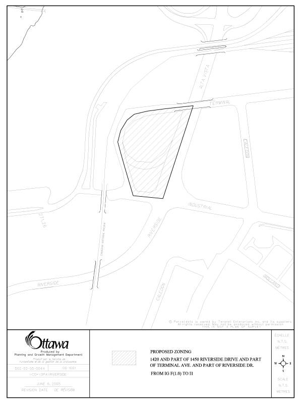
2. Approve an amendment to the former City of Ottawa Zoning By-Law
as shown in Documents 1 and 3 for 1420 and part of 1450 Riverside Drive, part
of Terminal Avenue and part of Riverside Drive, to change the zoning from “IG
F(1.0) – General Industrial Zone” to “I1 – Minor Institutional Zone”.
RECOMMANDATIONS DU RAPPORT
Que le Comité de l’urbanisme
et de l’environnement recommande ce qui suit au Conseil :
1. Approuver et adopter une
modification au Plan officiel de l’ancienne Ville d’Ottawa en ce qui concerne
le 1420 et une partie du 1450, promenade Riverside, une partie de l’avenue
Terminal et une partie de la promenade Riverside, de manière à modifier
l’annexe A – Utilisation du sol, qui passerait de « zone industrielle
traditionnelle » à « zone résidentielle », tel qu’exposé en
détail dans le Document 2 ;
2. Approuver une modification
au Règlement de zonage de l’ancienne Ville d’Ottawa, tel que décrit dans les
Documents 1 et 3, pour le 1420 et une partie du 1450, promenade Riverside, une
partie de l’avenue Terminal et une partie de la promenade Riverside, de manière
à faire passer le zonage de « IG F(1.0) – zone industrielle
générale » à « I1 – zone de petites institutions ».
BACKGROUND
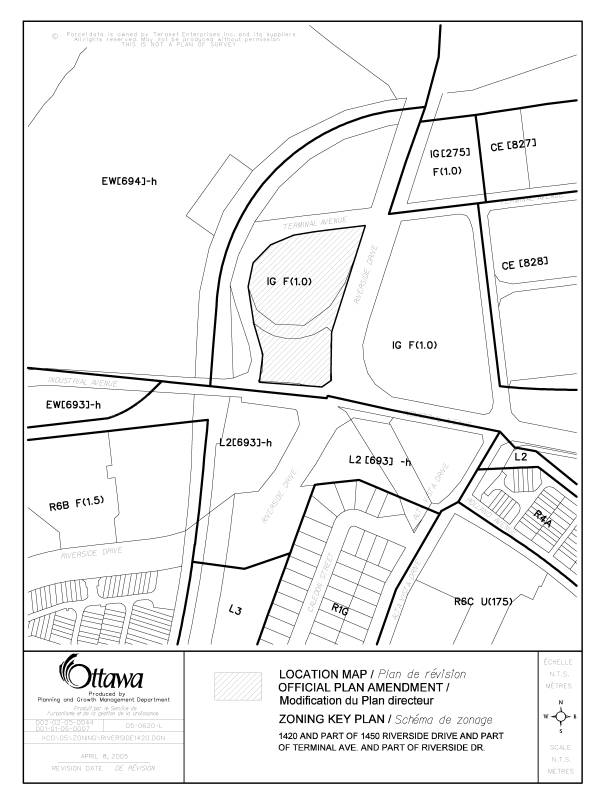
The subject property is known as 1420 and part of 1450 Riverside Drive, part of Terminal Avenue and part of Riverside Drive, as shown on Documents 1 and 3. The site is located on the west side of Riverside Drive, north of Industrial Avenue, and is encircled by Terminal Avenue. The site originally consisted of two properties owned by the National Capital Commission (NCC) that were separated by the Terminal Road on-ramp from Riverside Drive, which was owned by the City of Ottawa. The on-ramp bisects the property at approximately one-third the distance onto the property, in an east-west direction. This on-ramp section of Terminal Avenue has been closed however it remains in use under a lease arrangement between the City and the NCC. This lease expires December 2005. The closure of the on-ramp formed part of a series of land-exchanges between the NCC and the City. The site is approximately 17 600 square metre in area, it is ‘tear-shaped’ and it is vacant, except for three clusters of mature trees, situated at the northern edge of the property and on either side of the now closed Terminal Road on-ramp. A stormsewer bisects the north part of the parcel and it is protected by a nine-metre easement in favour of the City. Adjacent to the north and south of the site, past Terminal Avenue and Industrial Avenue, are additional parcels of vacant land owned by the National Capital Commission. To the east, across Riverside Drive is the main Canada Post depot and the lands known as the ‘Train Lands’. West of the site, past Terminal Avenue is the CNR rail line and the OC Transpo Transitway.
Official Plan and Zoning:
The site is designated ‘Mixed Use Centre’ on
Schedule B in the City Council Approved Official Plan. This designation applies to lands that have been
identified as strategic locations on the rapid-transit network and lie adjacent
to major roads. Development within this
designation is intended to take advantage of the opportunities offered by
transit for both internal and external commuting and ease of access on foot and
by bicycle. As the name implies, a mix
of uses including commercial, office, institutional and ecclesiastical
facilities are permitted within this designation.
The site is designated ‘Traditional Industrial Area’
on Schedule A in the former City of Ottawa Official Plan. This designation permits a mix of low-density
traditional industrial type uses intended to serve the City’s office,
commercial and technological sectors.
Development within this designation includes uses such as manufacturing,
warehouse, distribution, transportation and construction uses.
The subject property is currently zoned ‘IG F(1.0)’, a General Industrial Zone. The intent of this zone is to increase the viability of industrial lands by permitting a broad range of industrial uses, while limiting non-industrial uses to those supportive of the industrial function of the zone.
Proposal:
The National Capital Commission and the prospective purchaser,have entered into an agreement of purchase and sale for the site. The Purchaser proposes to develop a community centre and place of worship on the subject property. They have advised that the Jamatkhana Centre is a community cultural and social centre incorporating a place of worship for members of the Ismaili community. The proposed use is considered an institutional land use with characteristics that combine the features of a place of worship and a community centre.
To accommodate the proposed development, the applicant has submitted applications to change the land use designation of the parcel within the former City of Ottawa Official Plan from ‘Traditional Industrial Area’ to ‘Residential Area’ and to change the zoning from ‘IG F(1.0) General Industrial Zone’ to ‘I1 – Minor Institutional Zone’. No exceptions to the I1 zone are proposed. Although institutional uses, which include the proposed community centre and place of worship, are not permitted uses within the designation of the former City of Ottawa Official Plan and the Zoning By-law, the uses are permitted within the ‘Mixed Use Centre’ designation of the City Council Approved Official Plan. The applications therefore are limited to requested changes to the former City of Ottawa Official Plan and the Zoning By-law.
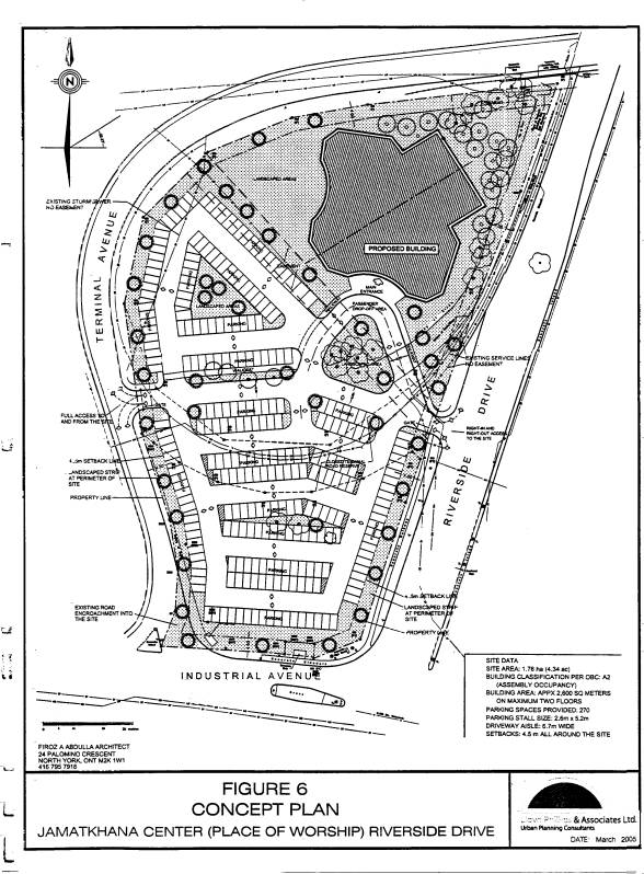
In support of their proposal to amend the Official Plan and zoning, the applicant has prepared a conceptual site plan illustrating the proposed layout of the site. As noted in Document 5, the conceptual site plan indicates that the proposed 2 600 square metre building has been situated within the north part of the site with the parking lot being situated within the south part of the site. The City’s storm sewer separates the building from the parking lot area.
The proposed building has been situated in accordance with the setback provisions of the I1 Zone. It is a two-storey structure with the main entrance to the building facing south, accessed by a passenger drop-off area and a landscaped traffic island in the foreground to the building. The parking lot, comprising approximately two-thirds of the site, is situated primarily south of the stormsewer. The number of parking spaces provided is 270 spaces, exceeding the minimum required 260 parking spaces. The applicant proposes two accesses to serve the site, consisting of a right-in-right-out intersection with Riverside Drive and a full movement intersection with Terminal Avenue. Of the three clusters of mature trees that exist on the property, as noted on the plan the majority of trees within the north part of the site will be retained however only some of the trees along the former on-ramp are proposed to be retained. Site development details such as tree preservation, landscaping and access will be examined through the Site Plan Control Process.
The applicant has indicated that they will shortly be submitting an application for Site Plan Control. The Site Plan Control application will consist of the submission of detailed site development, landscaping, engineering and servicing information.
DISCUSSION
City Council
Approved Official Plan
The proposed
development and requested rezoning conforms to the ‘Mixed Use Area’ designation
that applies to the site as set out in the Urban Area Land Use Schedule B of
the City Council Approved Official Plan.
Lands having this designation are intended to contain development that
is both locally and regionally oriented, take advantage of the opportunities
offered by transit, and contribute to the diversity of land use in the
immediate area and foster the creation of vibrant centers of activity. The type of development encouraged within
this designation includes offices, secondary and post-secondary schools,
hotels, hospitals, large institutional buildings, community recreation and
leisure centres, daycare centers, retail uses, services, high and
medium-density residential uses and mixed use developments containing
combinations of uses. The requested
zoning change meets the intent of the strategic directions in the City Council
Approved Official Plan for managing growth in the city, in that the proposal to
rezone the lands for institutional purposes occurs within the urban area,
utilizes existing services and transportation, and meets community needs for
the provision of institutional facilities.
Former Regional Official Plan
The subject lands are designated 'General Urban Area' in the former
Regional Official Plan. The policy
framework for urban areas permits communities to be mixed, diverse and
adaptable to changing needs, wherever possible shopping, services and community
facilities shall be in locations which are easily accessible by walking,
cycling, and transit as well as by automobile.
The Plan permits a wide range of residential, commercial, industrial and
institutional uses. In particular,
policy 3.6.1.provides for areas within 'General Urban Areas' are to be used
primarily for residential purposes, and the shopping services and community
facilities required to meet day-to-day needs.
The change in zoning of the subject lands for institutional purposes is
in conformity with these policies.
Former City of Ottawa Official Plan
The subject property is designated ‘Traditional Industrial Area’ on Schedule A within the Official Plan of the former City of Ottawa. The ‘Traditional Industrial Area’ designation permits a mix of low-density, traditional industrial type uses intended to serve the City’s office, commercial and technological sectors. Uses within this designation are considered to be medium and heavy type industrial uses that have the potential for operations that produce noise, fumes or their activity is visually dominant. Development within this designation includes uses such as manufacturing, warehouse, distribution, transportation and construction uses. Institutional uses such as the proposed community cultural centre incorporating a place of worship is not a use permitted within this designation.
Of the land classifications within the former City of Ottawa Official Plan, institutional uses such as that being proposed by the applications are permitted within the ‘Residential Area’ designation. The 'Residential Area' policies permit various residential and non-residential uses including institutional uses. The subject property forms part of a larger area, extending to the east and including the ‘Train Lands’, that is in transition from an area reserved for traditional industrial uses to one oriented to commercial office space, retail, residential, and mixed use developments. This change is reflected through the policy direction of the new City Council Approved Official Plan. Amending the former City of Ottawa Official Plan to establish a ‘Residential Area’ designation is consistent with the ‘Mixed Use Area’ designation established by Schedule A of the new City Council Approved Official Plan for the site.
Zoning By-Law Amendment
The applicant is requesting an ‘I1 Zone’ to allow the proposed community
cultural center incorporating a place of worship. In support of the applications, the applicant has provided a
conceptual site plan (Document 5) for the proposed development of the
site. The plan is based upon the
performance standards of the I1 Zone.
No exceptions to performance standards are being requested. The requested rezoning of the subject
property to the I1 Zone, as shown in Document 3, implements the Official Plan
Amendment, is acceptable and will promote a development that is appropriate and
desirable at this location with little impact on uses in proximity to the
property. The provision of parking for
parishioners of the facility within the site would satisfy the by-law
requirement for parking. Further, the
proximity to transit facilities provides the opportunity for parishioners to
utilize transit as an alternative to automobile use.
Traffic And Site Access Considerations
The applicant has submitted a traffic overview for their proposal. Two accesses are proposed to serve the site,
consisting of a right-in-right-out intersection with Riverside Drive and a full
movement intersection with Terminal Avenue.
A full movement intersection cannot be realized until such time as
improvements to the road network such as the construction of the intersection
of Terminal and Industrial have been realized.
The report identifies that use of the facility will occur early a.m. and
late p.m., and concludes that the traffic impact of the development on the road
system will be negligible.
As part of the examination of the traffic overview, City staff have identified
some issues in regard to site access relative to improvements to be undertaken
to the Terminal/Industrial intersection and Industrial Avenue. Staff have concluded that restrictions on
site access are necessary due to existing operational conditions, construction
schedule, and future projections for the area roads. Due to the land exchanges between the City and the NCC, the City
is proposing to proceed this year with limited improvements to Industrial
Avenue and Terminal Avenue subject to available funding. Regardless, access to the site from
Riverside Drive will therefore be limited to a right-in movement only due to
heavy volumes on Riverside Drive, as is the case for the existing on-ramp. Further, a road widening from the subject
property along Riverside Drive (and along Industrial Avenue) has been
determined to be necessary to effect a future dedicated right-turn lane onto
Industrial Avenue. Access for the site
will also be limited along Terminal Avenue to right-out movement only. Although modifications are to occur to
Industrial Avenue (including the shift westwards and the realignment of the
intersection of Industrial Avenue with Terminal Avenue), the initial planned
improvements do not go to the extent to permit a full movements access from the
site along Terminal Avenue. To enable a
full movement access to/from the site, utilizing Industrial Avenue as proposed
within the conceptual site plan, further roadway modifications would be
required on Terminal Avenue at Industrial Avenue. The applicant will have to consider the access restrictions, the
required road widenings along Riverside, Industrial and Terminal, in their
preparation of the formal site plan. In
support of the foregoing, the applicant will be required to submit a detailed
Traffic Impact Study as opposed to the overview which was submitted for this
application. It is at the Site Plan
Control stage of the planning approvals process that issues such as obtaining
road widenings, timing for construction, and ultimate access will be determined.
CONSULTATION
Notice of this application was carried out in accordance with the
City’s Public Notification and Consultation Policy. Information signs were posted on-site indicating the nature of
the applications. The Ward Councillor
is aware of the two applications. A
comment from the community association opposing the proposed change was
received. Comments have been received
from the public objecting to the proposal.
Seven enquiries from the public requesting information was received. Details of the notification and consultation
process are highlighted in Document 6.
FINANCIAL IMPLICATIONS
N/A
APPLICATION PROCESS TIMELINE STATUS
This application was processed by the "On Time
Decision Date" established for the processing of Official Plan and Zoning
By-law Amendment applications.
SUPPORTING DOCUMENTATION
Document
2 Proposed Official Plan Amendment
Document
3 Zoning Schedule
Document
4 Explanatory Note
Document 5 Conceptual Site
Plan
Document 6 Consultation
Details
DISPOSITION
Department of Corporate Services, Secretariat
Services to notify the applicant/planner Lloyd Phillips & Associates Ltd.,
Attn. Lloyd Phillips, 14 Woodlawn Avenue, Ottawa, ON K1S 2S9, the owner
National Capital Commission c/o Capital Planning/Real Asset Management Attn.
Curry Wood, 40 Elgin Street, Suite 202, Ottawa, ON K1P 1C7, the lawyer McCarthy
Tetrault LLP Attn. Michael Polowin, 40 Elgin Street, Suite 1400, Ottawa, ON K1P
5K6, the traffic engineer Delcan Corporation Attn. Ronald Jack, 1223 Michael
Street, Suite 100, Ottawa, ON K1J 7T2, the surveyor Fairhall Moffatt &
Woodland, Attn. David Woodlands 235 Terence Mathews Cr., Kanata, ON K2M 2B3,
All Signs, 8692 Russell Road, Navan, ON K4B 1J1, and the Program Manager, Assessment, Department of
Corporate Services of City Council’s decision.
Planning
and Growth Management Department to prepare the implementing by-law, forward to
Legal Services Branch and undertake the statutory notification.
Corporate Services Department, Legal Services Branch to forward the implementing by-law to City Council.
LOCATION MAP Document
1
PROPOSED OFFICIAL PLAN AMENDMENT Document
2
Official Plan Amendment /Modifications due Plan
directeur
To the Official Plan of the Former City of
Ottawa.
Land use
Utilisation du sol
INDEX
________________________________________________________________________
The Statement of
Components…………………………………………………………. i
PART A - THE PREAMBLE
Purpose………………………………………………………………………………….…1
Location………………………………………………………………………….………...1
Basis…………………………………………………………………………………….…1
PART B- THE AMENDMENT
Introductory
Statement……………………………………………………………………2
Details of the
Amendment…………………………………………………………...……2
THE STATEMENT OF COMPONENTS
PART A - THE PREAMBLE, introduces the actual
Amendment but does not constitute part of Amendment No. X to the former City of
Ottawa Official Plan.
PART B - THE AMENDMENT, consisting of the
following text and map attached as Schedule “A” constitutes the actual
Amendment No. X to the former City of Ottawa Official Plan.
PART A
- THE PREAMBLE
1.0
Purpose
The subject property, comprised of 1420
Riverside Drive, part of 1450 Riverside Drive, part of Terminal Avenue and part
of Riverside Drive, as shown on Schedule “A”, is presently designated
‘Traditional Industrial Area’ within the former City of Ottawa Official
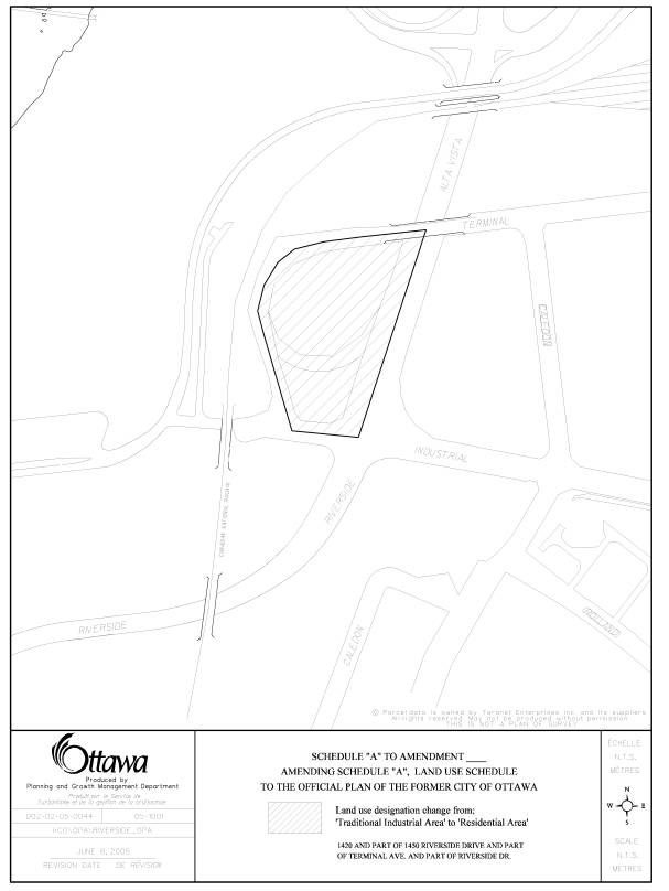
Plan. The purpose of Amendment No. X is to amend the land use designation for
the subject property from ‘Traditional Industrial Area’ to ‘Residential Area’,
as shown on Schedule “A”.
2.0
Location
The site is located on the west side of Riverside Drive, north of Industrial Avenue, and is encircled by Terminal Avenue. The site is approximately 17 600 square metre in area, is ‘tear-shaped’ and is vacant, except for clusters of trees. A storm sewer bisects the north part of the parcel and it is protected by an easement in favour of the City. Adjacent to the north and south of the site, past Terminal Avenue and Industrial Avenue, are additional parcels of vacant land owned by the National Capital Commission (NCC). To the east, across Riverside Drive is a three-storey office building occupied by Canada Post Corporation and the lands known as the ‘Train Lands’. West of the site, past Terminal Avenue is the CNR rail line and the OC Transpo Transitway.
3.0
Basis
3.1
Background
The site originally consisted of two properties owned by the NCC that were separated by the Terminal Road on-ramp from Riverside Drive, which was owned by the City of Ottawa. The on-ramp bisects the lands approximately at one-third the distance onto the property, in an east-west direction. This section of Terminal Avenue has been closed however it remains in use due to a lease arrangement between the City and the NCC, which expires December 2005. The closure of the on-ramp formed part of a series of land-swaps between the NCC and the City.
3.2
Context of Amendment
The Aga Khan Foundation has entered into an agreement of Purchase And Sale with the NCC for the site. The Aga Khan Foundation is requesting to change the land use designation of the subject property within the former City of Ottawa Official Plan from ‘Traditional Industrial Area’ to ‘Residential Area’ and to change the zoning from ‘General Industrial Zone to ‘I1 – Minor Institutional Zone’ to allow the development of the site for a community cultural and social centre incorporating a place of worship for members of the Ismaili community. Although institutional uses, which include the proposed community centre and place of worship, are not permitted uses within the designation of the former City of Ottawa Official Plan and the Zoning By-law, the uses are permitted within the ‘Mixed Use Centre’ designation of the City Council Approved Official Plan. The required amendment to the Official Plan therefore is limited to the requested change to the former City of Ottawa Official Plan.
PART B
- THE AMENDMENT
1.0
The Introductory Statement
All of this part of the document entitled Part
B - The Amendment, consisting of the following text and schedule included as
Schedule "A", constitutes Amendment No. X to the Official Plan of
former City of Ottawa.
2.0
Details of Amendment
2.1 To amend Schedule A – Land Use Schedule
of the former City of Ottawa Official Plan for lands known as 1420 Riverside
Drive, part of 1450 Riverside Drive, part of Terminal Avenue and part of
Riverside Drive from “Traditional Industrial Area” designation to “Residential
Area” designation, as shown in the attached Schedule “A”.
SCHEDULE “A” TO OFFICIAL PLAN AMENDMENT X
ZONING SCHEDULE Document
3
EXPLANATORY NOTE Document
4
THE FOLLOWING IS AN EXPLANATORY NOTE TO BY-LAW
NUMBER ______
By-law Number ______ amends Zoning By-law, 1998, the former City of
Ottawa's Comprehensive Zoning By-law.
This amendment affects 1420 Riverside Drive,
part of 1450 Riverside Drive, part of Terminal Avenue and part of Riverside
Drive, having a lot area of
approximately 17 600 square metres. The site is shown
on the attached location map. The site
is vacant, contains clusters of trees, and a closed road. The applicant requests to change the zoning
of the site to permit a cultural center including a place of worship.
Current Zoning
The current zoning is ‘IG F(1.0) – General
Industrial Zone. The purpose of the
zone is to maintain the function of large areas of traditional industrial lands
for a mix of industrial uses, at a low density; to increase the viability of
traditional industrial lands by permitting a broad range of industrial uses,
while limiting the amount and type of non-industrial uses to those that are
supportive of the industrial function of the zone; and, to ensure that only
light and medium industrial uses are located in areas designated in the Official
Plan as Traditional Industrial. This
zone allows a number of uses such as a building materials yard, dry cleaning
plant, garden nursery, light industrial uses, storage yard and warehouse. The F(1.0) is a provision that allows a
maximum floor space index of 1.0 times the lot area of a property, thereby
establishing the maximum permitted gross floor area of a building.
Proposed Zoning
The recommended zoning is the ‘I1 – Minor Institutional Zone’. The purpose of this zone is to permit a range of neighbourhood-serving, emergency, and institutional uses to be located in areas designated Residential Area and Central Area in the (former City of Ottawa) Official Plan, to minimize the impact on these areas by ensuring that institutional uses are located in close proximity to residential uses, are minor; are conveniently located so as to serve the needs of the community; and, are of a scale and intensity that is compatible with neighbourhood character; and impose regulations that ensure that these institutional uses are located in a manner which is compatible with adjacent land uses. This zone allows a number of uses including a community center, cultural, social and counseling center, day care, library, place of worship, and school. The proposed zoning change is to accommodate a cultural centre including a place of worship.
For further information on the amendment,
please contact David Loker at 580-2424 ext. 21234.
CONCEPTUAL SITE PLAN Document
5
CONSULTATION DETAILS Document
6
NOTIFICATION AND CONSULTATION PROCESS
Notification
and public consultation was undertaken in accordance with the Public
Notification and Public Consultation Policy approved by City Council for
Official Plan and Zoning By-law Amendments.
Seven enquiries with a request for information were received from the
public. A number of objections to the
proposal were received citing reasons including loss of greenspace, impact on
traffic and road network within the area, insufficient parking, road closure
process, and pedestrian access. No
public meetings were held in the community in which staff attended.
PUBLIC COMMENTS
1. Development of the parcel will result in loss of trees and green space.
Response
At present the lands are zoned to permit development. Regardless of the type of development, whether as industrial or institutional purposes, some loss of greenspace and/or trees would result. Tree preservation and landscaping in general are details that will be addressed through the Site Plan Control process.
2. Allowing access from the property onto Riverside Drive will result in an increase in traffic within the area. The vehicular traffic on these major access roads at most times of the day is very heavy and at rush hours, at times, both Riverside and Industrial can be totally jammed. The isolation of the proposed location in the midst of an industrial area creates serious concerns for the safety of those frequenting the community centre or the place of worship in that whether they arrive by bus, by vehicle or on foot they will encounter traffic. Further, slow vehicles exiting onto Riverside will result in slowing the flow of traffic and/or cause accidents.
Response
The applicant indicates on the conceptual site plan a proposed right-in/right-out along Riverside Drive. As noted within the report, Staff have examined the issue of access along Riverside Drive and determined that access to the site along Riverside will be limited to a right-in only as is the case for the existing on-ramp. Through Site Plan Control the issue of vehicular and pedestrian access, improvements to roadways, and timing for works will be examined in detail.
3. Traffic Study did not fully take into account the context of the whole ‘Mixed Use Centre’ and the associated and expected growth in pedestrian, cycling and vehicle traffic. The proposed community centre would be expected and encouraged to use public transit, yet there are no apparent provision for bus stops indicated in the submission.
Response
Staff are satisfied with the level of information contained within the Traffic Overview for the purposes of this land use proposal. Some of the conclusions of the report were not supported by Staff and as a result it is recommended that access to Riverside Drive be restricted. It is anticipated that the applicant will address issues raised through the comments received on the conceptual site plan, including landscaping, pedestrian connections, bus stops, road widenings, provision of parking, etc. as part of their preparation of the formal site plan to be submitted as part of the Site Plan Control process. The applicant will be required to submit a detailed Traffic Impact Study in support of the Site Plan application, which will address these issues.
4. The closing of the Terminal Avenue on-ramp did not seem to follow the normal procedure for street closing.
Response
The street closing for the subject on-ramp was completed in accordance with the City of Ottawa procedures.
5. Insufficient lands were retained by the City as part of the road closure and land exchanges with the NCC, to construct the modified intersection of Terminal and Industrial, for the provision of a turning lane on southbound Riverside Drive, for sidewalks to meet current planning guidelines, or for any possible bus stop locations. The closing of the on-ramp will divert traffic to other areas and will increase pressure on the road network.
Response
The street closing application for the Terminal Avenue on-ramp was limited to those lands associated with the right-of-way. Further, the series of land exchanges between the City and the NCC did not include lands noted above along Riverside Drive, Terminal Avenue or Industrial Avenue. As part of the future Site Plan Control process, necessary road widenings will be secured. In addition, road works identified as part of the approvals for the ‘Train Land’ Subdivision include provision for the reconstruction of Industrial Avenue and the intersection of Terminal/Industrial when warrants are met, and corresponding contribution of monies by the developer at a future date. In the short-term, minor modifications to both the intersection of Terminal/Industrial and to Industrial Avenue west of the Riverside Drive intersection are required to address today’s operational needs. Road works related to the phased ‘Train Lands’ development are longer-term considerations, and improvements to the road network will be constructed when warranted through the development of the ‘Train Lands’. Current traffic counts on the on-ramp indicated a low volume of traffic utilizing the on-ramp during peak hour conditions. Operational Staff indicated that removing the on-ramp could be accommodated within the existing network.
6. The hours of use indicated in the Traffic Report do not seem to be consistent with those posted for other similar community centres and places of worship, and traffic studies of actual similar places should be done to confirm the contribution to peak traffic levels. There could also be traffic restrictions and safety concerns with in-an-out turning events to Riverside Drive, a major road with 4450 vph volumes.
Response
The hours of operation noted within the Traffic Overview originate from the applicant. Regarding proposed right-in/right-out access, restrictions on access to Riverside Drive are recommended.
7. For the type of use being considered, the allowed occupant load is quite high and the on-site parking levels of 1 space per 10 square metres may not be adequate, particularly for special times of worship and community events. Where there is any overload need for parking, the site does not have adequate pedestrian linkages to any adjacent lands where overload parking may be available.
Response
Within the Zoning Bylaw the standard parking provision for a place of worship is 1 parking space per 10 square metres. The applicant has not identified a need for parking in excess of the minimum requirement, and has proceeded with the conceptual site plan on this basis. However the applicant did note that there would be a few times within a year that attendance is anticipated to exceed available parking. To address this shortfall, the applicant indicated that alternative arrangements to on-site parking to address potential excess demand is available through car-pooling, bussing and mass transit.
COUNCILLOR’S COMMENTS
Councillor Peter Hume is aware of the applications.
COMMUNITY ORGANIZATION COMMENTS
The Alta Vista Drive Residents Community Association provided a series of comments in regard to the applications.
1 The Association notes that when it was agreed to close the present right-hand turn lane from Riverside Drive South onto Terminal Avenue, it was agreed that this right hand turn possibility would remain and would be made via Industrial Avenue to Terminal Avenue. The concept site plan does not accommodate this and hence must be changed. The drawing shows a concrete pillar blocking such turns and even suggests that the present road encroaches on the property. This too must be changed to respect the agreements on the present road closure. Further, the Association recommends there also should be a right hand turn lane on Riverside South near Industrial to permit cars to properly queue and make the right hand turn.
Response
The City did not retain a right-of-way over the former on-ramp. A right-hand turn lane to enable vehicular movement from Riverside Drive onto Industrial Avenue and onto Terminal Avenue, is part of future road works. In regard to access onto their site, the applicant proposes to use access controls such as a barrier to prevent cut-through traffic.
2. The Association does not agree with a right-out onto Riverside Drive as proposed on the Site Plan, as this turning movement with cause confusion between cars wishing to make a right hand turn from Riverside Drive onto Industrial Avenue and those vehicles trying to access this site. Further, the site is close to the Railway Bridge and visibility is limited, as well as, vehicles weave among lanes in this section of Riverside Drive so that a right-out access would be very hazardous.
Response
Staff recommends a right-in only movement onto the site from Riverside Drive.