Report to/Rapport au :
Corporate
Services and Economic Development Committee
Comité des services
organisationnels et du développement économique
1 December 2009 / le 1 décembre 2009
Submitted by/Soumis par: Kent Kirkpatrick, City Manager / directeur municipal
Contact Person/Personne ressource : Gordon MacNair,
Director, Real Estate Partnerships and Development Office / directeur, Bureau
de développement et de partenariats immobiliers
(613)
580-2424 x 21217, Gordon.MacNair@ottawa.ca
SUBJECT:
|
disposal sTrategy - 3071
riverside drive – former bayview PUBLIC school |
|
|
|
OBJET :
|
STRATÉGIE D’ÉLIMINATION – 3071, PROMENADE RIVERSIDE –
ANCIENNE ÉCOLE PUBLIQUE BAYVIEW |
REPORT RECOMMENDATIONS
That the Corporate Services and Economic
Development Committee recommend that
Council:
- Retain the portions of the property at 3071
Riverside Drive shown as Parcels “A”
and “C” on Document 1 to allow for use as a sports field (approximately
0.791 ha / 1.95 ac) and for the construction of a field house
(approximately 0.09 ha / 0.22ac) respectively as described in this
report;
- Direct staff to pursue the acquisition of 2026
Springland Drive, shown as Parcel “D” on Document 1 attached and described
as Part of Lots 24 and 25 Junction Gore, shown as part 2 on plan 4R-12424
being all of PIN 040730129, for use as an access to the property at 3071
Riverside Drive as outlined in this report and report back on costs and
funding source in Q1 2010;
- Declare the property, shown as Parcel “B” on Document
1 attached containing an area of approximately 3.173 ha (7.85 ac),
described as part of Lot 24 Junction Gore, concession 2 (O.F.), Geographic
Township of Gloucester, now in the City of Ottawa, being part of PIN
040730076, as surplus to the City’s needs; and
- Direct staff to advertise the 3.173 ha (7.85 ac)
property, shown as Parcel “B” on Document 1 attached, for sale, subject to
development conditions as described in this report to ensure the
redevelopment of this property is compatible with the surrounding
neighbourhood.
RECOMMANDATIONS DU RAPPORT
Que le Comité des services
organisationnels et du développement économique recommande au Conseil :
- de conserver les portions de la propriété située au 3071, promenade
Riverside, affichée en Parcelles « A » et
« C » au Document 1, permettant son utilisation à titre de
terrain de sport (environ 0,791 ha / 1,95 acres) et pour la
construction d’un pavillon (environ 0,090 ha / 0,22 acre)
respectivement, tel qu’il est décrit dans le présent rapport;
- demander au personnel de rechercher l’acquisition du 2026,
promenade Springland, affiché en Parcelle « D » au
Document 1 ci‑joint et décrit comme faisant partie des
lots 24 et 25, Junction Gore, illustré comme étant la partie 2
sur le Plan 4R‑12424 et segment de PIN 040730129, pour fins
d’utilisation comme un accès à la propriété située au 3071, promenade
Riverside, tel qu’il est énoncé dans le présent rapport, et de faire
rapport sur les coûts et la source de financement au T1 de 2010;
- de déclarer la propriété, affichée en Parcelle « B »
au Document 1 ci‑joint, ayant une superficie d’environ
3,173 ha (7,85 acres), décrite comme faisant partie du
lot 24, Junction Gore, concession 2, orientée vers la rivière
des Outaouais, canton géographique de Gloucester, maintenant dans la Ville
d’Ottawa, segment de PIN 040730076, comme excédentaire aux besoins de la
Ville;
- de demander au personnel d’annoncer que la propriété de 3,173 ha
(7,85 acres), affichée en Parcelle « B » au
Document 1 ci‑joint, est à vendre sous réserve des conditions
de développement décrites dans le présent rapport dans le but de veiller à
ce que le réaménagement de cette propriété soit compatible avec le
quartier avoisinant.
BACKGROUND
City
Policy - Acquisition of Surplus School Properties
In May 2007, staff submitted a report with recommendations with respect to a policy for acquiring surplus school properties (“Policy for Surplus Schools” ref. # ACS2007-PTE-POL-0033) that was considered by the Planning and Environment Committee (PEC) and the Agricultural and Rural Affairs Committee (ARAC) in June 2007. Based on the recommendations of PEC and ARAC, Council, on 29 August 2007, approved as follows:
· that, where a school board within the City of Ottawa offers a school site as surplus to its educational needs, the City of Ottawa indicate an interest in acquiring this site on a case by case basis;
· that staff establish criteria for the evaluation of surplus schools sites for review and approval by the Agricultural and Rural Affairs Committee, Planning and Environment Committee and Council after which staff be directed to undertake an evaluation and prioritization of school sites for the purpose of identifying sites that would meet City needs should they be declared surplus or are already surplus;
· that these priorities be reviewed on an annual basis;
· that a funding strategy be brought forward for the 2008 Budget in order to acquire school board property that qualifies.
During the same period, the City received
notice from the Ottawa-Carleton District School Board (OCDSB), dated 27 June
2007, that 3071 Riverside Drive (Former Bayview School property) and 2720
Richmond Road (Former Grant Alternative School property) were surplus to the
Board’s needs and were being circulated to the City under Regulation 445/06 of
the Education Act. These properties were offered, in accordance with the
Regulation, to the “priority purchasers” which includes the City.
The City,
as a priority purchaser, had only this limited opportunity to submit offers to
purchase the Bayview and Grant School properties prior to these properties
being offered for sale on the open market. As a result, Council decided on 28
November 2007 (Report ACS2007-BTS-RPM-0042) to act on the acquisition of these
properties prior to establishing the criteria and priorities for acquiring
school properties and directed staff to pursue these acquisitions.
Acquisition of Former Bayview School Property
The City subsequently purchased the property at 3071 Riverside Drive (Bayview School property) from the Ottawa Carleton District School Board (OCDSB) on 31 October 2008 for $8,090,000 ($809,000 per acre) based on the directive given by Council on 28 November 2007.
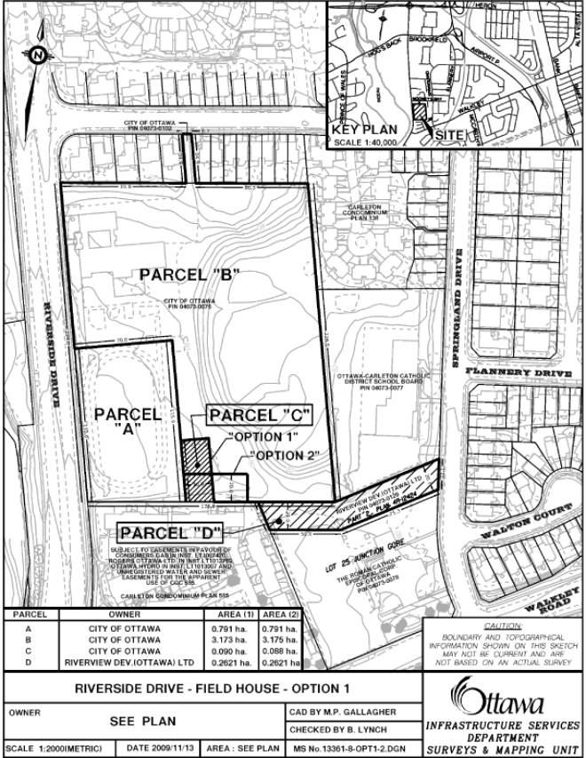
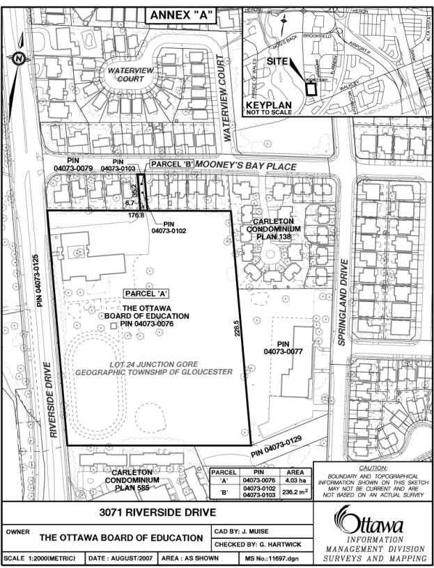
The subject property is currently a 4.054 hectare (10 acres) parcel of vacant land consisting of a main parcel (4.03 ha) and ancillary parcel (0.024 ha), that provides an access to Mooney’s Bay Place, shown as Parcels “A” and “B” respectively on the sketch plan attached as Document 2 to this report.
At the time this property was offered for sale, it was improved with a two storey 2,860 m2 (30,785 ft2) vacant school building, which has since been demolished, and a sports field.
The November 2007 Council directive also included for staff to report back to Council with an appropriate redevelopment plan outlining how this property can be optimized. Potential benefits and opportunities for the City in the acquisition of this property were identified at that time as follows: preserving recreational greenspace, providing a sports field, and selling and developing a portion of the property. The report noted that the developable portion of the lands could be offered for sale to a developer to create intensification within the greenbelt in support of the objectives of the Official Plan and to offset a portion of the acquisition cost for the property. The highest and best use for development was assumed to be low to medium density residential uses subject to rezoning and market conditions.
Prior to completion of the transaction, during the due
diligence period, soil contamination was discovered. Removal of the building
was required to undertake remediation of the site. This resulted in City
Council agreeing (8 October 2008) to contribute $435K toward the demolition of
Bayview School, subject to an environmental remediation holdback of $1.2M, with
the sale to close on 31 October 2008.
Since the closing, the OCDSB has demolished the school and remediated
the site. A Record of Site Condition (RSC) was submitted to the Ministry of the
Environment (MOE) on 22 July 2009.
On 17 November 2009, the MOE
completed its initial review and has requested additional information from the
OCDSB, which is to be submitted by 2 December 2009. As a result, the
environmental remediation holdback of $1.2M has not been paid to the OCDSB and
will not be paid out until the MOE has acknowledged that the RSC is complete.
DISCUSSION
Redevelopment Concept Plan
Following the closing of the sale, Real Estate Partnerships and Development Office (REPDO) staff, with assistance from both Planning and Growth Management and Parks and Recreation staff, prepared a background information package regarding the property and its potential for redevelopment.
On 19 May 2009, a Community-Visioning Workshop, organized by Councillor Maria McRae, was held at the Jim Durrell Community Centre wherein staff presented the background information and participants were invited to provide feedback on community needs and uses for the property and on concerns and criteria for the redevelopment of the residual lands.
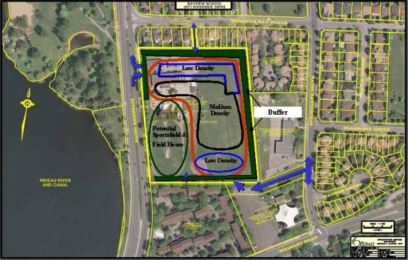
Participants’ comments were then summarized and used in the preparation of a follow-up Public Open House that was also organized by Councillor McRae and held on 10 September 2009 at the Jim Durrell Community Centre. A draft redevelopment concept, which broadly reflected community input to that time, was presented at that Open House. The Redevelopment Concept Plan received strong support at the Open House and includes, as shown on Document 3, the following:
· Provision for a sports field and field house with the preferred location being in the southwest corner of the site (same location as the former sports field), with wide community support for both. The preferred orientation of the field is north/south as recommended by Parks and Recreation staff;
· Residual lands to allow for redevelopment of low-density residential uses (one to two storey single detached and semi-detached and townhouses) in pockets abutting existing development at the north and south ends of the site and of medium-density residential uses (three to six storey townhouses, stacked units, and mid-rise condominium apartment dwellings) and/or institutional use (e.g. retirement home) in a pocket on the interior of the site overlooking the sports field and abutting the existing institutional (school) to the east;
· A buffer area between the existing development and future uses will be established; this will be a condition of the sale of the residual lands. The buffer will consist of fencing and/or landscaping features incorporated as part of the future development and may be rezoned as such;
· Vehicular access to the site, confined to a right in / right-out, is proposed to remain in its present location at the northern end of the site off Riverside Drive;
· A potential additional access via Springland Drive can be achieved through the acquisition of privately owned vacant land shown as Parcel “D” on Document 1 and municipally known as 2026 Springland Drive. This access would improve the accessibility of the site for southbound traffic by eliminating potential dangerous U-turns at Walkley Road and Riverside Drive. It would also provide better local access to the proposed sports field and field house. Although there was mixed reaction to this proposal, a majority of the respondents were in support;
· To maintain and improve pedestrian accessibility to existing and proposed greenspace, it is proposed that the existing access off Mooney’s Bay Place at the north end of the site, shown as Parcel “B” on Document 2, be converted to pedestrian access only. A second pedestrian access at the south end of the site from the existing condominium would remain unchanged.
In addition, the participants at the open houses indicated a strong desire that the redevelopment of the site take into consideration potential Sustainable Development Measures such as those set out in Document 4 attached to this report.
During and subsequent to the open house, several groups indicated an interest in developing a portion of the site for retirement home use.
Parks and Recreation Planning and Needs
Parks and Recreation Master Plan
On 23 April 2008, Council
approved the “Framework and Planning Process For A Parks And Recreation Master
Plan” (ACS2008-CPS-PAR-0003) to
respond to important questions such as “how the City should finance and deliver
recreation services to meet the existing and future program and service needs
of its residents.”
A subsequent report
“Parks and Recreation Master Plan - Consultation Results - Guiding Principals
and Key Recommendations” (ACS2009-COS-PRC-00120 was tabled at the
Community and Protective Services Committee (CPSC) meeting of 19 November 2009.
The report is to be considered at the CSPC meeting scheduled for 3 December
2009.
That report defines the City’s commitment,
operating principles and its relationship with programs, facilities,
communities and partners in providing parks and recreation services. It
contains a description of the public consultation process, the main themes and
concerns expressed by the public and the resulting principles and key recommendations
of the master plan for the future.
The report notes
that, during the consultation process, an overwhelming majority of respondents
indicated the importance of local neighbourhood based recreation while a clear
majority of respondents indicated that transportation is a factor that limits
access. Accordingly, the report recommends that future planning of facilities
must strike an appropriate balance between neighbourhood-based community centres and district and citywide
multi-use facilities. It also recommends that the City should reinvest and invest in neighbourhood-based recreation
services (directly and in partnership) and these services should be provided
based on interests and needs of individual communities recognizing that one
size does not fit all across the City.
In that respect, the report includes
recommendations as follows:
·
That recreation services be reasonably
accessible by neighbourhood and inclusive regardless of ability to pay,
culture, physical ability or age, including balancing neighbourhood-based
community centers with district and citywide multi-use facilities;
·
That the City
provide recreation facilities and program opportunities that reflect local
community interests and capacity to delivery within a broader citywide
framework, including provision of services based on interests and needs of the
community with allocation of space based on a balanced approach considering
changing demographics and historical patterns; and
·
That staff
report back in the first quarter of 2010 with the final Parks and Recreation
Master Plan that will provide a road map and timetable for the individual
policies that will be coming back to Committee and Council consistent with the
principles and recommendations set out above.
Recreation Facilities
- Concept Plan for Former Bayview School Property
With respect to the Mooney’s Bay Neighbourhood, Parks and Recreation staff have advised that the recreational facilities, shown on the development concept plan for the former Bayview School property, are considered to be in the City’s best interest as the school’s original sports field was well used and needs to be replaced. This is supported by the Department’s sports field strategy (2004) that indicated communities within the greenbelt are severely under-serviced with full-sized sports fields. Additionally, the school site was the location of a community-operated outdoor rink that needs a support building to house hoses and a change room. Given Riverside community have no indoor meeting space in the immediate neighbourhood (serviced by the Hunt Club/Riverside Community Centre for their full-range of recreational services and programming) the community building will provide the neighbourhood with a walk-to meeting space.
Parks and Recreation staff have, therefore, indicated that the resulting development plan should allow for the delivery of a 222 square metre (2,400 sq. ft.) community building together with approximately 12-15 parking spaces to support the sports field (washrooms), outdoor rink (change room) and indoor community space (2 small meeting rooms with sink) at an estimated cost of approximately $925,000. The estimated cost to construct a new non-lighted sports field is $175,000 although in this case some efficiencies will be achieved by locating the sports field in the same location as the former school field. These additional recreational facilities will have a total estimated capital cost of $1.1Million and associated yearly operating and life cycle costs.
Conclusions
Concept Plan - Recreation Facilities
In order to achieve the recreational facility
requirements set out in the concept plan as more specifically defined above by
Parks and Recreation staff, REPDO staff have concluded, and are recommending,
that an approximately 0.791 ha / 1.95 ac. portion of the property, shown as
Parcel “A” on Document 1, should be reserved for the sports field, and an
additional approximately 0.09 ha. /
0.22 ac. portion of the property,
shown as Parcel “C” on Document 1, should be retained to accommodate a field house (community building) and
associated parking lot.
Document 1 indicates two possible options for the location of Parcel “C” with the ultimate location being dependent on the development planning for Parcel “B” and the access right-of-way on Parcel “D”.
Site Access
In order to provide adequate and safe vehicular access for the contemplated redevelopment of this property in accordance with the concept plan, REPDO staff have concluded that a right-in / right-out only access be maintained in the present access location at the northern end of the site off Riverside Drive and that an additional access via Springland Drive should be provided through the acquisition of privately owned vacant land shown as Parcel “D” on Document 1 and municipally known as 2026 Springland Drive.
This access would improve the accessibility of the site for southbound traffic by eliminating potential dangerous U-turns at Walkley Road and Riverside Drive. It would provide better local access to the proposed sports field and field house and a greater opportunity to allow Parcel “B”, shown on Document 1 to be divided and zoned into sub-parcels for more flexibility when selling this land.
In view of the above, REPDO staff are recommending that the acquisition of Parcel “D” shown on Document 1, be pursued and, if acquired, that the development criteria include for a left turn out prohibition to Springland Drive to deal with concerns raised by some of the open house participants.
To maintain and improve pedestrian accessibility to existing and proposed greenspace, staff have also concluded, and are recommending, that the existing vehicular access off Mooney’s Bay Place at the north end of the site, shown as Parcel “B” on Document 2, be converted to pedestrian access only. A second pedestrian access at the south end of the site from the existing condominium will remain unchanged.
Redevelopment of Parcel “B”
Retention by the City of Parcels “A” and “C”, shown on Document 1 for recreational facilities will result in an approximately 3.173 ha (7.85 ac.) portion of the site, shown as Parcel “B” on Document, being available for redevelopment.
In order to ensure that Parcel “B” is developed in accordance with the Redevelopment Concept Plan that evolved from the community input at the Community Visioning Workshop and Public Open House organized by Councillor McRae, as illustrated on Document 3 attached, the redevelopment must include provisions for the following:
· Low-density residential uses (one to two storey single detached and semi-detached and townhouses) in pockets abutting existing development in the north and south ends of the site and for medium-density residential uses (three to six storey townhouses, stacked units, and mid-rise condominium apartment dwellings) and/or institutional use (e.g. retirement home) in a pocket on the interior of the site overlooking the sports field and abutting the existing institutional uses to the east (school) and south (church);
· A buffer area between the existing development and future uses will be established as a condition of the sale of the residual lands. The buffer will consist of fencing and/or landscaping features incorporated as part of the future development and may be rezoned as such;
· Sustainable Development Measures of the type indicated in Document 4 attached;
· REPDO staff believe that development concept for Parcel “B”, including the recommended access provisions, landscape buffer and sustainable development measures of the type shown in Document 4, can be implemented through a sale with conditions process and achieve a per acre revenue that is no less than the per acre amount paid by the City to the OCDSB.
Implementing the Redevelopment Concept Plan
As a result, staff have concluded that the following actions are required to achieve a sale of the property with provisions to ensure that the resulting development will be in accordance with the Redevelopment Concept Plan that evolved from the community input at the Community Visioning Workshop and Public Open House:
1. Have a legal reference plan (R-Plan) prepared to reflect the proposed development parcels of the Redevelopment Concept Plan described in this report;
2. Prepare and submit an application for a zoning amendment based on the parcels shown on the R-Plan and the provisions of the concept plan as described in this report;
3. Initiate negotiations with Riverview Dev (Ottawa) Ltd for the acquisition of the Parcel “D” as shown on Document 1 and report back to CSEDC and Council in Q1 2010, on the cost and funding source for this acquisition;
4. Prepare a sales package, including conditions that will require purchasers to:
· Submit a development concept plan that is consistent with the provisions of the proposed zoning amendment;
· Agree and support the zoning amendment for the property;
· Indentify those Sustainable Development Measures that are to be included in the development; and
· Enter into a related development agreement to ensure the development is implemented consistent with the purchaser’s concept plan and submitted with the offer, including the identified Sustainable Development Measures;
5. Advertise and offer the property for sale in Q1 2010 based on closing the sales transaction to by no later than Q1 2011; and
6. Report back to CSEDC and Council in Q2 2010 with recommendations for the sale of the property and the associated development agreement.
Recommended Action
As result, REPDO staff are now recommending that the City:
- Retain the portions of the property at 3071 Riverside Drive shown as Parcels “A” and “C” on Document 1 to allow for use as a sports field (approximately 0.791 ha / 1.95 ac.) and for the construction of a field house (approximately 0.09 ha / 0.22ac.) respectively as described in this report;
- Pursue the acquisition of 2026 Springland Drive, shown as Parcel “D” on Document 1 attached and described as Part of Lots 24 and 25 Junction Gore, shown as part 2 on plan 4R-12424 being all of PIN 040730129, for use as an access to the property at 3071 Riverside Drive as outlined in this report and report back on costs and funding source in Q1 2010;
- Declare the property, shown as Parcel “B” on Document 1 attached containing an area of approximately 3.173 ha (7.85 ac.), described as part of Lot 24 Junction Gore, concession 2 (O.F.), Geographic Township of Gloucester, now in the City of Ottawa, being part of PIN 040730076, as surplus to the City’s needs; and
- Advertise the 3.173 ha (7.85 ac.) property, shown as Parcel “B” on Document 1 attached, for sale, subject to development conditions as described above in this report to ensure the redevelopment of this property is compatible with the surrounding neighbourhood.
Staff will report back in Q1 2010
regarding the cost and funding source for acquiring Parcel “D”, shown on
Document 1 and in Q2 2010 on a recommend sale of Parcel “B”, shown on Document
1 and the net proceeds to be realized from that sale.
Based on the Parks and Recreation Master Plan
being finalized in Q1 2010, CESDC and Council will be in a better position to
give consideration in Q2 2010 as to whether or not the sports field and field
house improvements, with a total estimated capital cost of $1.1 M as noted in
this report, should be funded in whole or in part from the proceeds of the sale
of Parcel “B”
ENVIRONMENTAL IMPLICATIONS
The site has been remediated
by OCDSB, the former owner and a Record of Site Condition (RSC) has been filed
with the Ministry of the Environment (MOE). On 17 November 2009, the MOE
completed its initial review and has requested additional information from the
OCDSB, which is to be submitted by 2 December 2009. As a result, the
environmental remediation holdback of $1.2M has not been paid to the OCDSB and
will not be paid out until the MOE has acknowledged that the RSC is complete.
It is not anticipated that
the delay in MOE acknowledging completion of the RSC will have an adverse
affect on the development and sales process set out in this report but in no
event will REPDO staff advertise the sale of Parcel “B” until the RSC is
complete to the satisfaction of the MOE.
CONSULTATION
Local residents were
consulted in the preparation of the redevelopment concept plan outlined in this
report. The recommendations of this report have been formulated taking into
account the feedback from residents during the consultation process as
described in this report.
Planning and Growth Management staff provided preliminary development planning guidelines to help facilitate the public consultation process. Recreational and Parks staff participated in the development concept planning process and provided specific input as described in this report.
Councillor McRae is aware of the intent to dispose of the residual property (Parcel “B” as shown on Document 1) for redevelopment subject to conditions that will ensure that Parcel “B” is developed in accordance with the concept plan that evolved from the community input at the Community Visioning Workshop and Public Open House organized by Councillor McRae.
HOUSING FIRST POLICY
The Official Plan policy directs that the City make land available for affordable housing and give priority for the sale or lease of surplus City-owned property for this purpose.
The Housing First Policy, approved by Council on 13 July 2005, establishes priority consideration to the Affordable Housing Division in the identification of potentially surplus City-owned property, to be used in achieving the City’s affordable housing program targets. The policy also requires that the Official Plan target of 25% affordable housing, be met on any City-owned property sold for residential development. Where viable residential properties are disposed of without a condition requiring an affordable housing component, 25% of the proceeds from the sale are to be credited to a housing fund, to be used for the development of affordable housing elsewhere in the City.
The subject property is a viable property and therefore meets the affordable housing criteria outlined in the Housing First Policy.
LEGAL/RISK MANAGEMENT IMPLICATIONS:
There are no legal/risk management impediments to
implementing any of the Recommendations arising from this report.
FINANCIAL IMPLICATIONS
The recommendations set out in this report do
not require any further funding provision at this time.
SUPPORTING DOCUMENTATION
Document 1 - Sketch plan showing the redevelopment parcels
Document 2 - Sketch showing the subject property
Document 3 - Draft site redevelopment plan
Document 4 - Potential
sustainable development measures
DISPOSITION
Following approval, the REPDO will initiate the actions set out under the “Implementing the Redevelopment Concept Plan” portion of the Discussion section of this report.
DOCUMENT 1
DOCUMENT 2
DOCUMENT 3
Draft Site Redevelopment Plan
Compatibility with
Community comments:
• Higher
density abutting existing “I” zone
• Development
further back from road
• Sportsfield,
rink, field house
• Sportsfield
facing Riverside
• Access
to greenspace, walkways
• Generous
buffer around development
• Maintain
existing access
• Pursuing
acquisition of land for access off Springland
• Moneys
Bay Place pedestrian only
• Low
density adjacent to existing, medium density in middle
DOCUMENT 4
Potential Sustainable Development Measures
Site Measures:
•
Better ventilation and air
re-circulation to reduce dependency on the air-conditioner
•
Low-water /edible
landscaping, native, drought resistant plants, living fence
•
Porous Driveway surfaces
(minimum 25% of driveway area)
•
Dark Skies street lighting,
downward directed street lighting
•
Dust and air quality control
program
•
Construction waste management
plan
•
Storm Water retention plan on
lot basis
•
Rainwater to be collected for
irrigation (Minimum 200 litre container)
•
Urban heat island: at grade:
30% of hardscaped areas to be shaded at landscape maturity
•
70% of landscaping to be
covered by native species (drought resistant vegetation)
•
Landscaping for energy
conservation (for example: coniferous vegetation on north side and deciduous on
south, slow growing grass)
Building Measures:
•
Buildings specifications
which exceed Energy Star requirements e.g. R2000
•
Energy Star appliances and
fixtures
•
Used or recycled materials
(7.5 % minimum, cardboard, glass, cement fibreboard)
•
Passive Solar design, e.g.
increased windows facing south.
Increased radiant heat-absorbing materials in areas adjacent to south
facing windows. Decreased north facing windows. Increased insulation
•
Active Solar Hot Water
Heating, and Solar domestic hot water ready
•
Natural ventilation in lieu
of air conditioning and extend roof-line to block heat from the summer sun
•
Reduction of Urban Heat
Island: use of light coloured materials or green landscaped
roof
•
Web Connected Peaksaver
Thermostats and high efficiency furnace
•
Double insulated walls for
added warmth, quiet, draft proofing, and durability or provide exterior wall
insulation beyond OBC requirement and
double glazed low Argon Energy Star windows
•
35 Year Shingles or similar
Low Carbon Footprint material
•
Kitchen Recycling
Centre/Multiple Waste Stream Sorting
•
Locally Sourced Materials and
Recyclable
•
Low flow fixtures and dual
flush toilets preferred