Report to/Rapport au :
Planning
and Environment Committee
Comité de l'urbanisme et de l'environnement
and Council / et au Conseil
10 November 2009 / 10 novembre 2009
Submitted by/Soumis par : Nancy Schepers, Deputy
City Manager/Directrice municipale adjointe,
Infrastructure Services and
Community Sustainability/Services d’infrastructure et Viabilité des
collectivités
Contact Person/Personne-ressource :
Richard Kilstrom, Manager/Gestionnaire, Policy Development and Urban
Design/Élaboration de la politique et conception urbaine, Planning and Growth
Management/Urbanisme et Gestion de la croissance Élaboration de la politique et
conception urbaine
(613) 580-2424
x22653, Richard.Kilstrom@ottawa.ca
SUBJECT:
|
|
|
|
|
OBJET :
|
mise à jour du plan de conception
communautaire de riverside-sud |
REPORT
RECOMMENDATION
That Planning and Environment Committee recommend that Council approve the update to the Riverside South Community Design Plan as shown in Document 2 and as detailed in Document 3.
RECOMMANDATION DU RAPPORT
Que le Comité de l’urbanisme et de l’environnement recommande au Conseil
d’approuver la mise à jour du Plan de conception communautaire de
Riverside-Sud, comme il est indiqué dans le Document 2 et expliqué en détail dans
le Document 3.
BACKGROUND
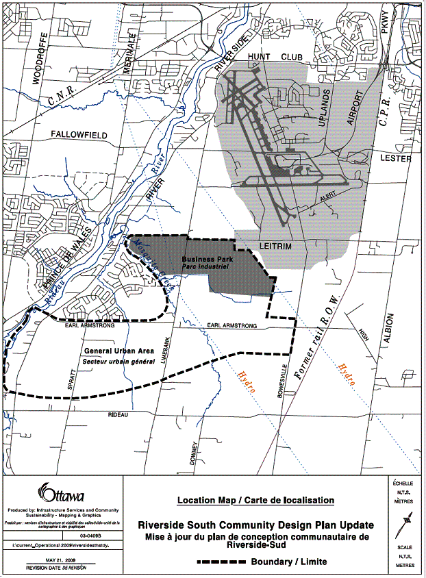
The Riverside South community is located east of the Rideau River and to the south of the Ottawa airport (Document 1). Council approved a Community Design Plan (CDP) for the community in June 2005. The CDP established the general arrangement of future land use for approximately 1400 hectares of undeveloped land and provided for a future population of about 52000 people in the community. The Master Servicing Studies prepared in support of the approved CDP were completed recently. Minor changes to the approved CDP are now required to reflect the outcome of these final studies.
At the time of approval of the 2005 CDP, staff indicated that a report would be brought back to Committee for consideration any substantive changes that may result from the finalisation of the master servicing studies. The CDP is a non-statutory document and therefore a formal amendment process under the Planning Act is not required. Section 8.4 of the CDP sets out the process and the circumstances under which staff will seek the approval of Committee and Council for updates to the document.
As a result of the completion of the master servicing studies, changes such as new locations for two stormwater management ponds and changes to the extent of, density and major road system layout in the employment area are now being brought forward for consideration and approval. Two other changes include the addition of a new English Catholic High School site in Neighbourhood 2 and new Park and Ride facilities in the Community Core Area.
DISCUSSION
Overview of Proposed Changes
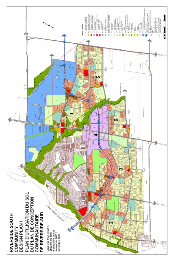
The updated CDP land use plan is attached (Document 2) along with a summary of text changes to the CDP guideline document (Document 3). Highlights of the more significant changes in the proposed update to the CDP are as follows:
· Width of “Green” corridor along Mosquito Creek valley increased.
- Two Stormwater Management ponds location, size and shape changed.
- Collector road intersections near pipeline easement relocated.
- Leitrim Road future by-pass in Employment Area moved to the northeast.
- Collector road layout in Employment Area redesigned.
- New Employment Area added to comply with Official Plan housing/jobs requirement.
- Land use at the Spratt Road/Limebank intersection changed.
- New English Catholic High School site added.
- New rapid transit Park and Ride locations added.
- Projected number of dwellings increased from 19200 to 20300.
- Projected population increased from 52000 to 54500.
Mosquito Creek Valley
“Green” Corridor
The limit of development adjacent to the Mosquito Creek valley was further refined through environmental studies prepared in support of the Master Drainage Plan for the community. The revised limit, which is shown by the edge of the green colour on the CDP Land Use Plan, now reflects the greater of 15 metres from top of bank, the erosion access allowance, meander belt width, limit of significant woodlots and extent of adjacent fish habitat locations. The land area of the valley corridor increased from approximately 60 hectares on the 2005 Plan to approximately 79 hectares on the updated CDP. All applicable setback parameters are to be further refined at the time of development approval through additional detailed studies as may be required.
Stormwater Management Ponds
The final Master Drainage Plan recommended the addition of a new storm water management (SWM) pond in the southerly part of Neighbourhood 5, adjacent to Mosquito Creek and abutting the urban boundary. It also divided a large SWM pond located in the Employment Area adjacent to Mosquito Creek into two ponds, a smaller one remaining next to the creek valley and a larger one in a new location, also in the Employment Area, abutting the east side of Limebank Road.
Collector Road Intersections
with Trans-Northern Pipelines Inc. Easement
Two collector road intersections, Collector “F” at Spratt Road and Collector “G” at Earl Armstrong Road, were moved slightly to respect recommended intersection setbacks to the Trans-Northern Pipeline easement. Adjacent land use blocks were also adjusted accordingly.
Future Leitrim Road By-pass
and Employment Area Collector Roads
The 2005 CDP located the future Leitrim Road By-pass through the central part of the Employment Area. It was to function as an interim collector road and be upgraded to arterial road status if and when the future airport runway over existing Leitrim Road was built. The 2003 Limebank Road Environmental Assessment (EA) showed the by-pass road located in the northeasterly part of the Employment Area for illustrative purposes. The EA described that the final location would be subject to a future detailed design process.
The fish habitat study work carried out for the 2008 master drainage study identified fish habitat within a portion of the future Leitrim Road by-pass right-of-way as shown on the 2005 CDP. Also, a large stormwater management pond was relocated abutting a 600-metre length of the future by-pass road resulting in less opportunity for direct property access for future employment uses. As a result, the proposed CDP update relocates the Leitrim Road by-pass to the northeasterly portion of the Employment Area, in approximately the same location as illustrated in the 2003 EA.
Collector roads in the Employment Area have been relocated to respond to the new locations for the Leitrim Road by-pass and stormwater management ponds. The east and west parts of the Employment Area are now accessed at and are connected by a new collector road intersection located at Limebank Road. Local roads may be added to the Employment Area at the time of subdivision approval to provide access to smaller development parcels.
Employment Area Expanded
The Official Plan requires the provision of 1.3 jobs per household in the Riverside South community. Jobs are counted (estimated), for example, within the employment area, commercial sites, and schools and in home occupations. The changes to the Employment Area described previously in this report (Leitrim Road by-pass relocation, enlarged and relocated SWM ponds and increased width of the setback limit to Mosquito Creek) resulted in a reduction to the land area available for employment uses. Additionally, the actual number of homes constructed in the northwest part of the community is higher than was projected at the time the original CDP was prepared. This slight decrease in employment area, combined with an increase in the number of homes resulted in a deficit to the projected 1.3 jobs per housing unit ratio in the community.
To compensate for these changes, the employment area was expanded in Neighbourhood 1 to include an additional 20.6 hectares of land located to the south of the light rapid transit right-of-way and in-between Collector “G” and the easterly urban boundary. This area is designated General Urban Area in the Official Plan and is shown as low and medium density residential in the 2005 CDP. Also, it is proposed that the minimum employment density be increased from 80 jobs per hectare to 120 jobs per hectare for all employment land located within approximately 600 metres of the two Employment Area rapid transit stations. This increased density would apply to approximately 62 hectares of the Employment Area located to the south of the Airport Operating Influence Zone boundary. This increase in employment density also supports the policy direction of the City to encourage higher density uses of land in proximity to transit stations.
It is projected that there will be approximately 20315 dwelling units in the community. This results in a minimum target of 26410 jobs within Riverside South. The combination of adding new employment area and increasing employment density is sufficient to achieve this target by providing for approximately 27900 future jobs.
Land Use Change at the
Spratt Road/Limebank Road Intersection
Two factors have influenced the need to change the future land use arrangement on or near to three of the four corners at the Spratt Road/Limebank Road intersection. Firstly, the widening of Limebank Road to accommodate the current four-lane road construction occurred entirely on the west side of the right-of-way. This caused the remnant parcel in-between the road and the hydro tower corridor to be functionally too small for the planned neighbourhood commercial site. Secondly, a valley that extended to the east of Limebank Road from Mosquito Creek was designated as protected fish habitat in studies prepared in support of the recently completed Master Servicing Studies. This meant that the institutional block in this area had to be relocated.
The northwest corner of the Spratt Road/Limebank Road intersection is proposed for the new location for the institutional block on the updated CDP since the hydro corridor and remnant parcel adjacent to Limebank Road provide opportunity for vehicle parking and landscaping. The small local commercial block, formerly on the northwest corner, is now proposed on the southeast corner. Relocating the commercial block to this corner has the benefit of providing improved access to convenience shopping for future residents in Neighbourhood 1 on the east side of Limebank Road.
The block on the northeast corner of the Spratt Road/Limebank Road intersection is proposed to change from medium density residential (town homes) to high density residential “1” (stacked town homes). This helps to balance the housing density lost on the south side of Spratt (new commercial site location) and provides opportunity to develop residential on the corner without noise barrier walls. This is achieved by orienting the front of units facing Spratt Road and Limebank Road. The approved CDP supports increased density in locations close to transit services in the community.
New English Catholic School Board High School Site
The English Catholic School Board commented that it requires an additional high school site within the existing CDP area to serve the communities of Riverside South and Leitrim as approved. To compare, the communities of Kanata and Barrhaven have populations as of the 2006 census of approximately 67000 and 55000 respectively. Each of those communities has two existing Catholic high schools that are operating substantially at capacity. Riverside South is projected to have an approximate population of 55000 and the Leitrim community has a projected population of 15000 for a total of approximately 70000. Since the Catholic high schools in Riverside South will service both communities, the Board has requested the additional site.
A new
eight-hectare site has been added in the southerly part of Neighbourhood 3 at
the Spratt Road/Collector “J” intersection.
The CDP Guideline document will include provision for a possible
relocation of this second high school site to a future expansion area of the
community if the expansion occurs in advance of the Board’s need for the second
site. If the relocation occurs, the
site would return to a residential land use on the CDP Land Use Plan. The other three school boards have no
objections to the addition of this new high school site.
New Core Area Rapid Transit Park and Ride
The May 2009 “iTrans” study on park and ride facilities for the rapid transit corridor confirmed the Transportation Master Plan requirement for a park and ride facility to be located in the Riverside South Community Core. The “Limebank Park and Ride”, a 1175 parking stall facility, is expected to be constructed in 2031. Notably, since the CDP was approved in 2005, the “Main Street” transit station in the Core area is now the future change point (terminus) for light rail transit and bus rapid transit.
The park and ride facility has been divided into two lots, one lot on the west and one on the east side of Limebank Road. The easterly lot is approximately 1.5 hectares in size and will accommodate about 375 cars. The westerly lot is approximately 3.0 hectares in size and will accommodate about 800 cars. The approximate location and extent of the park and ride lots has been added to the CDP Conceptual Core Area Plan and to the Land Use Plan. Separating the park and ride into two lots avoids the impact of a single large parking area, has less impact on intended future land use in the Core and offers improved proximity to both Core Area transit stations. The intent is that these park and ride facilities could eventually be reduced in size or eliminated. This could occur depending on need determined at the time of development and based on whether or not the existing River Road park and ride remains fully or partially opened.
The CDP Guideline document will be revised to include identification of the new park and ride lots in the Core Area. If the lots are reduced in size at the time of construction in 2031 and/or in phases over time after construction, the residual land would be developed for a City or institutional facility abutting Transit Street and for high density residential in other areas as per the 2005 CDP. The addition of the park and ride to the Core Area results in a reduction of approximately 185 stacked town home dwelling units compared to the June 2005 CDP.
In February 2006
Council approved the Riverside South Core Area Urban Design Guidelines. Staff will modify this document too, by
replacing the Conceptual Core Area Plan with the one updated as part of the
approved changes to the Riverside South CDP.
Increase in Projected Number
of Dwelling Units and Population
The total number of dwelling units projected for the Riverside South community has increased by 1100 from about 19200 in the 2005 CDP to about 20300 in the updated 2009 CDP. This is reflective in part of the increase in the number of homes actually constructed within the north-westerly quadrant of the community (4850 units), compared to the estimated number of homes (3050 units) at the time the 2005 CDP was prepared.
The increase of
approximately 1800 constructed units in the northwest quadrant, compared to the
estimate, was offset slightly by a minor decrease (700 units) in the
number of estimated future homes within the CDP area. The reduction of approximately 700 units is primarily a result of
land that is shown as residential on the approved 2005 CDP being changed to
stormwater management facility, high school, Core Area park and ride and
employment area. As a result of the
projected net increase of 1100 dwelling units, the total estimated population
for the community has increased by about 2500 from approximately 52000 to
approximately 54500 people.
Parkland Dedication
Council approved a new parkland dedication by-law this year. The by-law changes the way parkland is dedicated for higher-density forms of housing compared to the approach used at the time the CDP was approved in 2005. The 2005 CDP calculated parkland dedication for all densities of residential at a rate of 1 hectare for every 300 dwelling units.
The new Parkland Dedication By-law caps the parkland dedication for apartment blocks at 10 per cent of the associated land area. This has the effect of reducing the amount of projected parkland dedication for high density residential by approximately 4.1 hectares.
Compared to the 2005 CDP, the number of residential units (excluding apartments) in the proposed 2009 CDP update is reduced by approximately 700 units (refer to discussion above). This has the effect of reducing the associated parkland dedication requirement by approximately 2.3 hectares.
The resulting overall community-wide parkland dedication requirement for all types of development is 52.2 hectares. The recommended approach to respond to this change is to reduce slightly the land area for each of the 24 planned parks in the CDP area, rather than eliminate two or three entire parks. This approach balances community-wide parkland area with the revised estimated amount of development in the community and ensures continuation of optimum park proximity to residential. The resulting park sizes remain within acceptable size range for the intended function of the planned park space.
The land area associated with the district park in Neighbourhood 1 has been enlarged on the updated CDP to accommodate a 5.5 hectares area required for the future Riverside South recreation complex. This additional land is not part of parkland dedication required as a result of development, but will be purchased by the City with Development Charge funds. The location of the recreation complex within the district park will be decided as part of a future planning process.
Compliance with 2009 Official Plan
The 2009 Official Plan adopted by Council in June this year requires an increase in density to a minimum of 34 units per net hectare for new residential development in greenfields areas. The 2005 Riverside South CDP is designed at 31 units per net hectare but includes provision for density increases for all areas in proximity to transit. Since the 2005 CDP complied with the 2003 Official Plan when it was approved by Council and the recommended CDP update is not a “new” CDP, it is not necessary to redesign the plan so that it complies with the policies of the recently adopted 2009 Official Plan. The updated 2009 CDP does however comply with other new requirements of the 2009 Official Plan such as the minimum target density of 80 people and jobs per gross hectare in the CDP “Core Area”.
ENVIRONMENTAL IMPLICATIONS
The recently completed Master Servicing Studies have provided an additional level of detail regarding the proximity of development adjacent to natural features in the community, along with recommended systems for management of stormwater and provision of municipal water and sanitary sewers. Additional detailed environmental and servicing studies will be required as part of the usual City requirements at the time of development approval within the CDP area. These studies may further refine, for example, the limit of development adjacent to natural features and result in the adjustment of road and land use locations as shown on the updated Community Design Plan.
RURAL IMPLICATIONS
N/A
CONSULTATION
Landowners directly affected by the proposed changes were consulted through project meetings and/or at a public open house meeting. The community-at-large was consulted at a public open house meeting held at the Rideauview Community Centre on June 23, 2009 and response to the proposed update was positive. Note that the new high school site and the park and ride lots were added to the CDP following the open house meeting. The draft CDP update was also circulated to technical agencies and City departments for comment in July 2009. Comments received are summarised in Document 4.
COMMENTS BY THE WARD COUNCILLOR
The Ward Councillor has been advised of the proposed update and has no objections.
LEGAL/RISK MANAGEMENT IMPLICATIONS
There are no legal/risk management issues associated with the approval of the update to the CDP.
CITY STRATEGIC PLAN
The proposed update to the Riverside South CDP supports Objective 6 of the Sustainable, Healthy and Active City Priority, “Require walking, transit and cycling oriented communities and employment centres”, by increasing Employment Area density in proximity to rapid transit stations.
TECHNICAL IMPLICATIONS
N/A
FINANCIAL IMPLICATIONS
There are no financial implications associated with the approval of the update to the CDP.
SUPPORTING DOCUMENTATION
Document 1 Key Map.
Document 2 Updated CDP Land Use Plan.
Document 3 Summary of CDP text changes.
Document 4 Consultation Details.
DISPOSITION
Planning and Growth Management staff to undertake
required amendments to the “Riverside South Community
Design Plan Implementation Guidelines” document and to the “Riverside South Core
Area Urban Design Guidelines”
document to reflect the updates as approved by Council in this report.
KEY MAP DOCUMENT 1
UPDATED CDP LAND USE PLAN DOCUMENT 2
SUMMARY OF CDP TEXT CHANGES. DOCUMENT 3
The following are the highlights of the proposed changes to the Riverside South Community Design Plan Implementation Guidelines:
Section 1.3 – Policy Context, 5th
paragraph;
Delete in its entirety.
Section 2.2.2 – Road Hierarchy, a.
Arterial Roads, 4th bullet;
Delete in its entirety.
Section 2.2.3 – Rapid Transit Corridor, 2nd paragraph;
Delete in its entirety and replace it with the following text:
“A 20-metre wide rapid transit right-of-way has been protected through the community. In order to ensure the most efficient rapid transit operation possible, provision will be made for corridor widening at stations and future grade separation at all arterial and major collector road crossing points. The station location at “Main Street” in the Core Area is the terminus of the light rail transit line connecting the community to downtown Ottawa, and the starting point of the bus rapid transit line to the west.”
Section 2.2.7 – Employment Areas, 1st
and 2nd paragraphs;
Delete both in their entirety and replace with the following text:
“The Employment Area is located adjacent to the Airport lands. It will be serviced by the arterial and collector road network, rapid transit corridor and bus transit. Using employment densities of 80 jobs per net hectare and 120 jobs per net hectare, the total potential number of jobs within the Employment Area is estimated to be approximately 17,000 jobs. This is based on a calculation using approximately 129 net ha at 80 jobs/ha and approximately 56 net ha at 120 jobs/ha. Employment Area lands located to the south of the Airport Operating Influence Zone (AOIZ) as shown on the Land Use Plan must achieve a minimum development density of 120 jobs per net hectare. All other Employment Area lands must achieve a minimum development density of 80 jobs per net hectare. A net hectare excludes valley lands, storm water management ponds and roads.
The Employment Area could accommodate office-oriented employment, in keeping with Ottawa’s high-tech and government services industries, while its strategic location close to the airport could also attract other trade-related businesses. The range of employment types and associated employment numbers that are projected to establish in other parts of the community is set out in Table 1.”
Section 2.2.7 – Employment Areas, Table 1;
Delete in its entirety and replace it with the following updated Table 1:
Table 1. Jobs/Units Ratio
|
Units
(Existing + Neighbourhoods 1-6) |
20,315 |
|
Jobs |
|
|
Employment Area
(62 ha – 10% x 120 jobs/ha) |
6,680 |
|
Employment Area
(143 ha – 10% x 80 jobs/ha) |
10,310 |
|
Mixed Use Area
(39 ha x 100 jobs/ha) |
3,900 |
|
Commercial (19
ha x 50 jobs/ha) * |
950 |
|
Institutional
(11 @ 3.3 jobs/ha) ** |
36 |
|
Schools (5 high
sch. @ 100 jobs ea and 12 elem. sch. @ 40 jobs ea) *** |
980 |
|
District Parks
(2 @ 100 jobs ea) |
200 |
|
Home Occupations
(10 jobs/100 residential units) |
2,032 |
|
Sub
Total Jobs |
25,088 |
|
Ratio Jobs/Units |
1.23 |
|
Airport Lands
(39 ha – 10% x 80 jobs/ha) |
2,808 |
|
Total Jobs |
27,896 |
|
Ratio Jobs/Units |
1.37 |
* Includes 5.213 ha commercial area in
existing community. ** Includes two institutional sites in
existing community.
***
Includes
two elementary schools in existing community.
Section 2.3.1 – Density Distribution, Sub. a), Low Density, 2nd
paragraph;
Adjust the unit mix percentages as follows:
“…mix of about 42.4% singles and semis, 37.5%
townhouses and 9.5% ground-oriented stacked townhouses (the remaining 10.6%
being apartments and non-ground oriented stacked townhouses),…”
Section 2.3.6 – Schools, 3rd
paragraph;
Add to the third paragraph the following:
“The English Catholic high school site located in Neighbourhood 2 is to be relocated to a future expansion of the Riverside South community if such urban boundary expansion is approved prior to subdivision approval of the high school block and the Catholic School Board’s need for this site.”
Section 2.3.6 – Schools, Table 2 Schools by Neighbourhood
Delete in its entirety and replace it with the following updated Table 2:
|
Neighbourhood |
Schools |
Area (ha) |
|
1 |
1 English Catholic Elementary (EC) |
2.43 |
|
1 English Public Elementary (EP) |
2.83 |
|
|
1 English Catholic High School (EC) |
8.09 |
|
|
1 English Public High School (EP) |
6.50 |
|
|
2 |
1 English Catholic Elementary (EC) |
2.43 |
|
1 English Public Elementary (EP) |
2.83 |
|
|
1 French Public Elementary (FP) |
2.43 |
|
|
1 English Catholic High School (EC) |
8.00 |
|
|
3 |
1 English Catholic Elementary (EC) |
2.83 |
|
1 English Public Elementary (EP) |
2.83 |
|
|
1 French Catholic Elementary (FC) |
2.43 |
|
|
1 French Public High School (FP) |
5.26 |
|
|
1 English Public High School (EP) |
7.68 |
|
|
5 |
1 English Public Elementary (EP) |
2.83 |
|
6 |
1 English Public Elementary (EP) |
2.83 |
Section 2.3.9 – Rapid Transit South Extension
Delete in its entirety (since southerly extension no longer in TMP).
Section 4.1 – Open Space, Introduction, 2nd paragraph;
Adjust open space areas and percentages as follows:
“Based on the Official Plan target for total public greenspace of 4 ha per 1,000 population, a total of approximately 163 ha of greenspace is desirable in the future community. The combined greenspace requirements of the existing and future communities in Riverside South total 218 ha. In comparison, the total greenspace area for parks, valleylands, stormwater management areas, woodlots and hydro and pipeline easements is approximately 280 ha (which does not include existing and proposed parks in the northwest quadrant). This provides an overall greenspace ratio in the community of 5.1 ha of greenspace per 1,000 population. Put another way, the 280 ha of greenspace represents 21% of the CDP area, exceeding the Official Plan target range of 16 – 20%.”
Section 4.2.1 – Parkland Requirements, 1st Paragraph;
Delete in its entirety and replace it with the following text:
“Parkland within the CDP area will be provided in
accordance with the Ottawa parkland dedication by-law as amended from time to
time. This by-law requires parkland
dedication for apartment blocks at rates slightly lower than permitted by the Planning
Act. The Planning Act permits
acquisition of parkland at 1.0 ha for every 300 dwelling units (and 2% of land
area for commercial and industrial uses).
The Ottawa parkland dedication by-law caps parkland dedication for
apartments at 10% of the associated land area.
The total parkland requirement in the CDP area under the Ottawa parkland
dedication by-law is 52.2 ha. This
reflects a 4.1 ha reduction in parkland requirement for planned apartment
blocks under the parkland dedication by-law as well as a 2.3 ha reduction
resulting from fewer dwelling units.
Section 5.1 – Community Core Site Plan Guidelines, b. Parking Areas;
Add a new third paragraph as follows:
“Two park & ride facilities for the rapid transit system are located in the Core Area. Both are located to the south of the rapid transit corridor, one on the east side of Limebank and one on the west side. The easterly lot is approximately 1.5 ha in size and will accommodate about 375 cars. The westerly lot is approximately 3.0 ha in size and will accommodate about 800 cars. Both of the park & ride lots may be fully or partially phased out over time as the community matures and the need for centralised rapid transit parking facilities is reduced.
If the park & ride lots are reduced in size in the future, the
northerly portion of the lot west of Limebank Road where it abuts “Transit
Street” should be made available first for redevelopment, preferably for a
municipal and/or institutional facility.
The entire easterly lot and the southerly portion of the westerly lot in
proximity to Collector “T” should be redeveloped as stacked town homes or other
higher density residential land use if the park & ride facility is not
needed in the future.”
Section
6.3 – Employment Areas Built Form, 1st Paragraph;
Delete the first sentence and replace it with the following:
“The Employment Area is located in
the northerly portion of the Community.”
Section
7.2 – Water Distribution Analysis, 1st and 4th
paragraphs;
Delete “and the higher lands are
to be serviced through a new pumping station fed from the low lying area” in
the 1st paragraph. Delete the 4th
paragraph in its entirety.
Section
7.4 – Stormwater Management, 3rd and 4th paragraphs;
Delete the 4th
paragraph in its entirety and delete the last sentence of the 3rd
paragraph and replace it with:
“A preferred alternative was
developed incorporating five new storm ponds within the Community Design Plan
area, which forms part of the Land Use Plan.”
Section
8.4 – Process to Amend the Community Design Plan, 1st paragraph;
Change “Director of Planning and Infrastructure Approvals”
to:
“General Manager, Planning and
Growth Management”
Section
8.4 – Process to Amend the Community Design Plan, 2nd paragraph;
Delete the first sentence in its entirety and replace it
with the following:
“Where substantive changes to the
Land Use Plan are proposed such as to the number and location of larger high
density residential, commercial and employment blocks, to the location of major
roads, to the design of the Core Area and to the relocation of school and large
park blocks, the proposed change(s) will be subject to approval by Planning
& Environment Committee.”