Report to/Rapport au :
Planning and Environment Committee
Comité de l'urbanisme et de l'environnement
29 July 2010 / le 29 juillet 2010
Submitted by/Soumis par : Nancy Schepers, Deputy City Manager/
Directrice municipale adjointe, Infrastructure Services and Community Sustainability/Services d’infrastructure et Viabilité des collectivités
Contact Person/Personne-ressource : Michael Wildman, Manager/Gestionnaire, Development Review-Suburban Services/Examen des projets d'aménagement-Services suburbains, Planning and Growth Management/Urbanisme et Gestion de la croissance
(613) 580-2424, 27811 Mike.Wildman@ottawa.ca
|
SUBJECT: |
ZONING - 1491 and 1493 Stittsville Main Street (D02-02-08-0263) |
|
|
|
|
OBJET : |
REPORT RECOMMENDATIONS
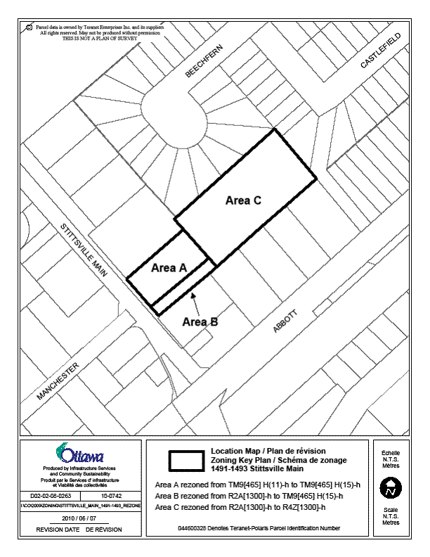
That the Planning and Environment Committee recommend Council approve an amendment to the Zoning By-law 2008-250 to change the zoning of 1491 and 1493 Stittsville Main Street from TM9[465]H(11)-h (Traditional Mainstreet Subzone 9, Exception 465, Height 11 metres, Holding Zone) and R2A[1300]-h (Residential Second Density Subzone A, Exception 1300, Holding Zone) to TM9[465]H(15)-h (Traditional Mainstreet Subzone 9, Exception 465, Height 15 metres, Holding Zone) and R4Z[1300]-h (Residential Fourth Density Subzone Z, Exception 1300, Holding Zone) as shown in Documents 1 and 3, and as detailed in Document 2.
RECOMMANDATIONS DU RAPPORT
Que le Comité de l’urbanisme et de l’environnement recommande au Conseil d’approuver une modification au Règlement de zonage 2008-250 afin de changer la désignation de zonage des 1491 et 1493, rue Stittsville Main de TM9[465]H(11)-h (Zone de rue principale traditionnelle, sous-zone 9, assortie de l’exception 465 et d’une hauteur de 11 mètres et avec aménagement différé) et R2A[1300]-h (Zone résidentielle de densité deux, assortie de l’exception 1300 et avec aménagement différé) à TM9[465]H(15)-h (zone de rue principale traditionnelle, sous-zone 9, assortie de l’exception 465 et d’une hauteur de 15 mètres et avec aménagement différé) et à R4Z[1300]-h (Zone résidentielle de densité 4, sous-zone Z, assortie de l’exception 1300 et avec aménagement différé), comme il est indiqué dans les documents 1 et 3 et expliqué en détail dans le document 2.
BACKGROUND
The subject site includes the two properties known as 1491 and 1493 Stittsville Main Street, located on the east side of Stittsville Main Street, slightly north of Abbott Street, in Stittsville.
The subject site is comprised of two properties: 1491 Stittsville Main Street is a rectangular parcel occupied by two commercial buildings, while the property at 1493 Stittsville Main Street is a rectangular parcel to the rear of 1491 Stittsville Main Street, with a long narrow access to Stittsville Main Street. It is undeveloped and largely wooded. The site, illustrated in Document 1, has a combined street frontage of 36.8 metres, a depth of approximately 150 metres and an area of 0.7 hectares.
The surrounding uses along Stittsville Main Street comprise a mix of commercial uses, including the Royal Canadian Legion building located on the abutting property to the north, some residential and office uses to the south and commercial uses on the west side of Stittsville Main Street. Detached dwellings fronting on Abbott Street, Castlefield Crescent and Beechfern Avenue border the north, south and east sides of the property. The southwest corner of the site abuts a pathway connecting Abbott Street and Castlefield Crescent.
Purpose of Zoning Amendment
The purpose of this Zoning By-law amendment is to facilitate a proposed development comprised of a mixed use building along the street frontage and five, three-storey residential buildings at the rear of the site.
Existing Zoning
The property at 1491 Stittsville Main Street (front portion of site) is zoned TM9 [465]H(11)-h (Traditional Main Street Zone, Subzone 9, Exception 465, Height 11 metres., Holding Zone). The purpose of the TM Zone is to accommodate a broad range of uses including retail, service, commercial, office, residential and institutional uses, including mixed-use buildings. The site‑specific exception denotes a rear yard setback of 5.22 metres.
The property at 1493 Stittsville Main Street (vacant rear portion of site) is zoned R2A [1300]-h. (Residential Second Density Zone, Subzone A, Exception 1300, Holding Zone). The zone permits primarily detached, semi-detached and duplex dwellings. The Subzone identifies specific zone provisions for lot area, lot frontage, yard setbacks and height. The site-specific exception denotes a minimum lot width of nine metres.
The zoning in effect for the site reflects a Committee of Adjustment decision that was rendered for the site in 2005. The parcel originally had a commercial zoning across the entire frontage with a land-locked residentially zoned parcel at the rear. The severance created a nine-metre frontage for the residential zone, which was subsequently rezoned to the residential zone. The severance had been sought to allow a development of six semi-detached buildings (12 units) on the residential portion of the property, with the nine-metre strip allowing for a private street to provide access to the rear portion of the site. The intended development proposal was not pursued.
Both parcels are affected by a holding zone, as indicated by the lower-case ‘h’ at the end of the zone code. Recently, the subject site was included within the Holding Zone proposed for certain lands tributary to the Hazeldean Pumping Station. It was identified that an upgrade was needed to the pumping station in order to keep pace with projected growth demands. The holding zone is to be placed on certain lands to manage growth with respect to available capacity, until it can be demonstrated that there is sufficient capacity at the pump station following the scheduled upgrade works. Until specified conditions are met, the ‘h’ will permit only those uses existing at the time of enactment of the by-law to continue with no adverse impacts. New development would not be permitted to proceed until sufficient capacity was available.
History of Development Proposal
The applicant submitted concurrent applications for zoning and site plan control in December 2008. The proposal called for the front portion of the site to be developed with a five-storey building consisting of retail on the ground floor, offices on the second and third floor and residential apartments on the fourth and fifth floors. The proposed building height was 15 metres, requiring an amendment to the 11-metre height limit in effect. Forty parking spaces were proposed in a lot at the rear of the building, with 19 of them having a reduced width of 2.4 metres rather than the standard 2.6 metres. Access to the site was by way of a private street extending through a carriageway bisecting the building.
The original proposal included six three-storey residential buildings containing a total of 36 stacked units at the rear of the site. Twelve units had a private garage and driveway, with the remainder of the parking provided in lots at the rear of each building, adjacent to the yards of the surrounding detached dwellings. The applications were circulated for technical and public comments in January 2009. There was some community opposition to the proposal, on the basis of both density of the residential development and the height of the mixed-use building.
Primarily in response to concerns expressed by the Councillor and the public with respect to the compatibility of the development, the proponent revised the proposal to scale back the residential component of the project by reducing the number of stacked units at the rear of the property. The site plan was revised, and changes to the plan introduced in November 2009. The proposal for the mixed-use building on the front portion of the site remained unchanged, but the parking layout for the building was revised, providing 34 full-size parking spaces.
More significant revisions were undertaken for the proposed residential development at the rear portion of the property: Five three-storey buildings containing a total of 28 stacked units were proposed, rather than the initial proposal of six buildings containing 36 units. Parking was increased, with 16 units having two parking spaces (a garage with additional parking space in driveway), and the remaining 12 units each having one outdoor parking space in front of the building. The rear yard parking lots previously proposed were eliminated, providing additional landscaped space between the proposed buildings and the adjacent lots. The proposed height was within the height of 11 metres permitted by the current zoning. A 1.4-metre screen fence was proposed along the residential portion of the property line.
In June 2010, the concept plan was further revised to reduce the number of dwelling units from 28 to 24. The 12-unit building at the rear of the site was modified to contain eight units, with eight parking spaces to be provided in front of the building. Landscaped space would be provided around the perimeter of the site between the proposed buildings and the adjacent residential lots, and a 1.8-metre wood screen fence was proposed along the entire property line.
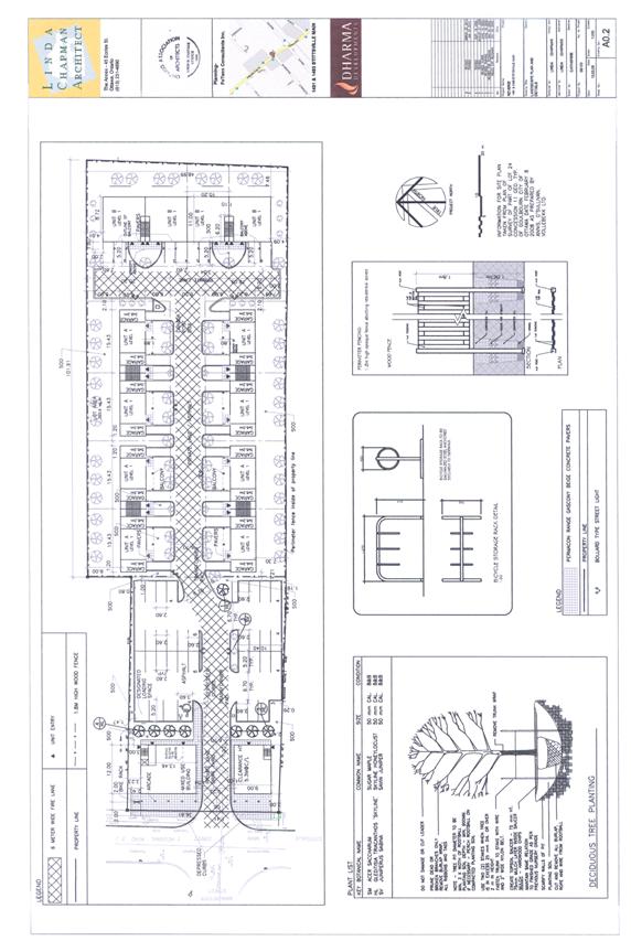
The Zoning By-law amendment application has been submitted to permit the implementation of the latest proposed development. The proposed site plan is illustrated in Document 5.
Proposed Zoning
The requested bylaw amendment includes amending the site specific TM9 Zone to increase the permitted building height from 11 to 15 metres, and extending that zone across the frontage of the property; reducing the required landscaped space around a parking lot not abutting a street from 1.5 metres to 0 metres; requiring a modified loading space, and rezoning the rear portion of the site from the R2A Zone to a site-specific R4Z Zone, with specific yard setbacks, and a slight reduction in required parking. A 1.8-metre wood screen fence would be required along the rear and side lot lines of the property.
DISCUSSION
Provincial Policy Statement
The Provincial Policy Statement (PPS) provides direction on matters of provincial interest related to land use planning and development. The Planning Act requires that decisions affecting planning matters “shall be consistent with” such policy statements issued under the Act. PPS policies indicate that there should be an appropriate mix of uses to support strong, liveable, and healthy communities, and densities that efficiently use land and support alternative transport modes.
The subject proposal conforms to the PPS. The proposal promotes an efficient, cost effective pattern of development, stimulates economic growth and takes full advantage of existing infrastructure. The proposal promotes a liveable community by expanding the range of choice in housing types offered in Stittsville. The PPS promotes intensification and redevelopment opportunities within built up areas where existing or planned infrastructure can support development. The proposal takes full advantage of an available opportunity to revitalize lands within an established neighbourhood. The proposed development includes a mix of residential and locally-oriented commercial uses, which will efficiently use land and contribute to a balanced community. The site is centrally located on an arterial road, which provides good access by pedestrians and transit. Staff conclude that the proposal is consistent with the matters of provincial interest as outlined in the PPS.
Official Plan
Land Use Designation
The front portion of the property is designated “Traditional Mainstreet” and the rear portion of the property falls within the “General Urban Area” designation in the Official Plan.
The Traditional Mainstreet designation identifies streets that offer significant opportunities for intensification through more compact forms of development, a lively mix of uses and a pedestrian-friendly environment. The Traditional Mainstreets exhibit compact urban character and a mix of uses that provide for access by a variety of transportation modes. Mainstreets are intended to function as mixed-use corridors in order to sustain the surrounding community, transit system, and to provide a focus for the community.
In addition to encouraging infill and redevelopment along Traditional Mainstreets that optimizes use of land through increased building height and density, the policies also address urban design. In order to enhance the pedestrian environment, surface parking is not generally permitted between the building and the street where it can be avoided. Buildings along Traditional Mainstreets are required to have a minimum building height of two storeys and the Official Plan supports a building height in the range of four to six storeys. A broad range of uses is permitted on Traditional Mainstreets, including retail and service commercial uses, offices, residential and institutional uses.
The proposed development represents intensification of the site. Although Traditional Mainstreets have no specific density targets expressed in the Official Plan, they are one of the target areas in the city where intensification is to be directed, and as such, intensification of the magnitude proposed satisfies the intent of the Official Plan policy. The proposed development achieves a more intense, yet human-scaled built form in this part of Stittsville and will contribute to supporting the public transit system and community services, as well as providing services to the surrounding community. The proposed development meets the intent of the Traditional Mainstreet designation.
The General Urban Area designation affecting the rear portion of the site permits the development of a full range and choice of housing types to meet the needs of all ages, incomes and life circumstances, in combination with conveniently located employment, retail, service, cultural, leisure, entertainment and institutional uses. The Official Plan supports infill where it enhances and complements existing areas and contributes to their long-term vitality. The Official Plan directs growth to established areas in order to maximize the use of land that is already serviced, accessible and close to existing amenities. The proposed residential development at the rear of the property satisfies these Official Plan policies, by making efficient use of a vacant parcel that is serviced, accessible and close to amenities, while expanding the choice of housing types available in the community.
Compatibility and Urban Design
Sections 2.5.1 and 4.11 of the Official Plan outline the objectives and policies for compatible development. As well, the Design Guidelines for development along Traditional Mainstreets, and the Design Guidelines for Low-Medium Density Infill Housing are applicable to this site, and these provide further details about compatibility and design. The proposed development has also been evaluated in light of the Stittsville Main Street Design Guidelines.
Section 2.5.1 provides guidance on how to appropriately incorporate infill development into existing built up areas. According to the Official Plan, compatible development means development that is not necessarily the same as or similar to existing buildings, but enhances and coexists with existing properties, without undue adverse impacts. It is development that ‘fits well’ with its surroundings. The Official Plan states that these objectives are achievable without designing a development to be the same as existing developments. Section 2.5.1 also states that urban design is an important ingredient in creating liveable spaces.
Section 4.11 of the Official Plan sets out criteria that are used to evaluate compatibility of proposed developments. The Official Plan acknowledges that in some situations, compatibility of infill development may be more difficult to achieve than in other situations. Areas adjacent to major roads and at the periphery of neighbourhoods may allow more intensive development than has occurred in the past. In these circumstances, the compatibility must be carefully considered. Criteria that can be used to evaluate compatibility include: traffic, vehicular access, parking, height and massing, pattern of surrounding community, outdoor amenity area, loading, service and outdoor storage areas, lighting, noise and air quality, sunlight, and supporting neighbourhood services.
The proposed development meets the criteria for compatibility as follows:
• Traffic: Stittsville Main Street is classified as an existing arterial road, meant to carry a large volume of traffic. Although the proposed development does not necessitate a Transportation Impact Study as per the City’s guidelines, the applicant submitted a Transportation Brief in support of the proposed zoning amendment. The Transportation Brief indicated that there would be no significant impact on traffic as a result of this development, and that no road modifications were required. Although Stittsville Main Street is currently experiencing congestion at peak times, the capacity of the street and nearby intersections are sufficient to safely accommodate the proposed traffic into the local road network. The configuration of the proposed site access and the alignment with Manchester Street is considered to be safe and appropriate, and no road modifications were required. The development proposed currently comprises 24 stacked units, rather than the original 36 units, so the impact would be less than predicted by the Transportation Brief.
• Vehicular Access: Location of vehicular access should address nuisance on adjacent properties and should be oriented to non-local streets. The site will be served by one shared access from Stittsville Main Street in order to maintain a continuous building along the street front. Minimizing the number of driveways to one ensures improved vehicular flow on Stittsville Main Street, and a safer pedestrian environment. The proposed entrance has been aligned as closely as possible with the intersection of Stittsville Main Street and Manchester Street. Sight lines from the carriageway access provide exiting traffic with an unobstructed view of Stittsville Main Street, allowing safe merging into traffic.
• Parking Requirements: Infill developments should have sufficient parking to minimize potential for spill-over parking on adjacent streets, and opportunities to reduce parking should be considered. A total of 34 parking spaces are provided for the mixed-use building, satisfying the bylaw requirement. By-law 2008-250 requires that the 24 stacked units have 1.2 parking spaces per unit with an additional 0.2 spaces for visitor parking (total 1.4 spaces per unit), for a total of 34 spaces for the residential development. Forty spaces are provided to serve the residential development at the rear of the property. Sixteen of the units have a private garage and driveway, providing parking for two vehicles. A slight reduction in the parking requirement from 1.4 spaces per unit to 1.0 space per unit is proposed for the eight units that do not have a private garage and driveway. One space per unit is to be provided in front of the building, and no visitor spaces will be required. Although not required, visitor parking will be available in the parking lot adjacent to the mixed-use building, with a shared parking arrangement being implemented. The development has no vehicular connection to adjacent residential street and will not generate any spillover parking off-site.
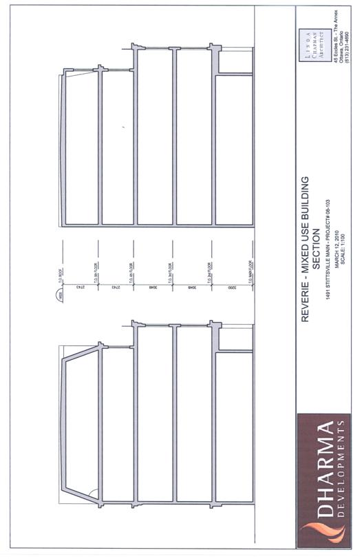
• Building Height and Massing: New buildings should have regard for both the existing context and planned function of the area. Design principles that contribute to a human sense of scale will enhance compatibility. The proposed building height of five storeys is consistent with building heights prescribed in the Official Plan for infill development within established low-rise residential communities. Although existing buildings on Stittsville Main Street are primarily one or two storeys in height, it must be recognized that over time, the surrounding properties on Stittsville Main Street will intensify to the 11-metre height limit. The one shared access helps in maintaining a continuous building along the street front, with the building design incorporating a carriage-way entrance to maintain building massing and achieve a traditional architectural theme. The design of the building also presents a stepping back of the facade, with the upper two floors of the building recessed, and visual interest provided by the balconies. The front building elevation is illustrated in Document 6. The proposed building height is 14.7 metres, measured at the highest point of the roof surface. Because the fifth floor is tucked into the roofline, the perceived height of the building is minimized. Document 7 illustrates the profile of the building and the setback of the upper two storeys.
• Pattern of Surrounding Community: The built form of the surrounding community varies, with the commercial character of Stittsville Main Street along the frontage of the site and the residential subdivision to the rear. The proposed residential built form provides appropriate transition from the commercial character of Stittsville Main Street to the low density residential character of the area. The development is ground-oriented with active pedestrian uses such as street-level retail, and encompasses the live-work-play concept by proposing professional offices on the second and third floor of the mixed-use building, together with residential on the fourth and fifth floors. The parking needed to serve the development is located at the rear where it does not visually impact the pedestrian experience. The pedestrian-oriented focus is reinforced through the provision of a shared driveway between the mixed-use development along Stittsville Main Street and the residential complex at the rear.
Similarly, the low profile of the residential development at the rear provides an appropriate transition from the abutting detached residential community to the north, south and east. The General Urban Area designation supports ground-oriented housing forms such as triplex and low-rise stacked units as an appropriate housing form for infill development in established low‑rise residential communities. The proposed residential development at the rear is kept low profile to ensure there are no undue adverse impacts on adjacent properties. Proper screening in the form of fencing and landscaping will ensure that any noise and light generated by the development is absorbed internally
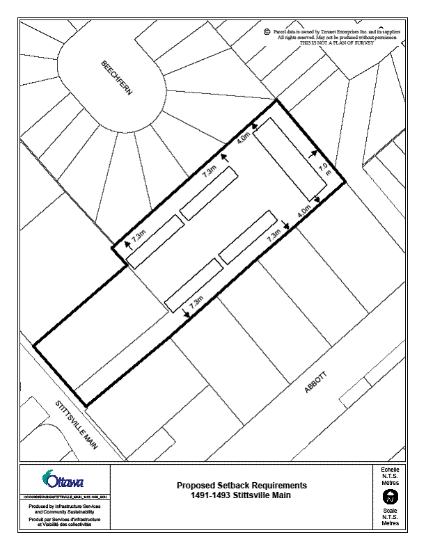
• Outdoor Amenity Area: New developments are to respect privacy of outdoor amenity areas of adjacent units. Siting of the proposed residential buildings close to the internal private laneway provides separation from the shared lot lines, ensuring that windows are not directly overlooking the yards of neighbouring properties. There will be a yard setback of 7.3 metres from the rear wall of the units to the lot line and a yard setback of four metres from the side wall of the units to the lot line. The privacy of adjacent neighbours will be protected through landscaping and a 1.8‑metre wood screen privacy fence proposed around the perimeter of the development.
• Loading Areas, Service Areas and Outdoor Storage: Operational characteristics and visual appearance of loading and garbage facilities should be mitigated. Services and storage for the proposed development will be contained internally, and operational activities will be minimal, limited to garbage pick-up and snow removal in the winter. Garbage for the mixed use building will be stored internally, while enclosures for the residential buildings are located in an enclosed area at the end of each building. A loading space will be provided for the mixed-use building.
• Lighting: The potential for spill-over or glare from lighting should be avoided. Lighting will be positioned in such a way that it is directed away from adjacent uses. Site plan control specifications require that full cut-off lighting fixtures be used to prevent glare on adjacent properties. The small parking areas that were initially proposed at the rear of each building, adjacent to the abutting properties, have been removed and replaced with a landscaped strip 7.3 metres in width. Lighting will be addressed in detail at the time of the site plan control application.
• Noise, Air Quality, and Sunlight: New developments should minimize potential nuisance related to noise or odour, and minimize shadowing on adjacent properties. No impacts have been identified, since the proposed use will not generate significant noise or odour. There will be some minor shadowing from the mixed-use building along the street frontage to the north of the site, but minimal impact on nearby residential properties.
• Supporting Neighbourhood Services: The proposed development is adequately served by all services and amenities. It is located in close proximity to a number of parks, community centres and the library. The proposed increase in density helps to support existing neighbourhood services and bring new residents into the area.
Community Design Guidelines
In May 2006, the City approved Community Design Guidelines to promote and achieve appropriate development along streets designated Traditional Mainstreets in the Official Plan.
Among the objectives in the guidelines are the following:
a) be compatible with and enhance the recognized or planned scale and character of the street;
b) achieve high-quality built form and strengthen building continuity along the street;
c) encourage compact, pedestrian-oriented development linked to street level amenities;
d) accommodate a broad range of uses including retail, commercial, offices, residential and where one can live, shop and access amenities;
e) comply with the suggested building setbacks, entrance treatments, architectural treatments and site access guidelines.
The proposed development satisfies the desired design for Traditional Mainstreets, which includes a minimum building height equivalent to two storeys, siting of buildings close to the street, and location of parking in the rear to maintain a continuous building mass and frontage along the streetfront. The proposed development will be visually attractive and architecturally interesting, making a positive contribution to the streetscape. The development is ground-oriented with active pedestrian uses such as street-level retail, which together with the mix of office and residential uses on the floors above contribute to the live-work-play concept and enhance the surrounding pattern of development along Stittsville Main Street. The parking needed to serve the development is located at the rear of the building, where it does not visually impact the pedestrian experience. The pedestrian-oriented focus is reinforced through the provision of a shared driveway between the mixed-use development along Stittsville Main Street and the residential complex at the rear.
At the time of site plan control approval, the building elevations will be evaluated in light of the Stittsville Main Street Design Guidelines. The proposed development achieves the intent of these through the use of warm and neutral colours, gabled roofs, vertical proportions, and the inclusion of residential above commercial for the building facing Stittsville Main Street. Building materials proposed for the mixed-use building are a combination of stone, brick and stucco. The fourth and fifth floors are recessed to reduce visual impact of the building and maintain a human scale along the street, while balconies provide interest on the facade.
Servicing
Servicing and stormwater management aspects of the development were reviewed as part of the site plan control application. Recently, the subject site has been included within the Holding Zone proposed for certain lands tributary to the Hazeldean Pumping Station. It was identified in 2008 that an upgrade was needed to the pumping station in order to keep pace with projected growth demands. The holding zone is to be placed on certain lands to manage growth with respect to available capacity, until such time as capacity at the Hazeldean Pump Station can be demonstrated through an upgrade to accommodate additional flow. The lands affected by the holding zone are primarily vacant properties with development potential, or developed lands having redevelopment potential. The holding zone would be lifted when capacity has been demonstrated. The site plan control application may continue to be processed and approved, with a condition specifying that site works may not take place until the holding provision has been lifted.
Zoning By-law Amendment
The proposed zoning for the site is described in Document 2. The requested by-law amendment would retain the Holding Zone provision and includes the following new provisions:
(a) Rezoning of the TM9[465]H(11)-h Zone to TM9[465]H(15)-h Zone, to increase building height maximum from 11 metres to 15 metres; reduce required landscaped space around a parking lot not abutting a street from 1.5 metres to 0 metres; and to require a modified loading space;
(b) Rezoning of the nine-metre strip of land along the southerly lot line from R2A [1300]-h to the site-specific TM9 [465]H(15)-h Zone to extend that zone across the entire frontage of the property;
(c) Rezoning the rear portion of the site from R2A to a site-specific R4Z[1300]-h Zone, with the following provisions: rear yard, where it abuts a rear yard on an abutting lot, to be 7.3 metres; interior side yard, where it abuts a rear yard on an abutting lot, to be 4.0 metres, required parking for stacked units without a garage and driveway to be reduced from 1.2 to 1.0 parking space per unit, and that visitor parking for stacked units without a garage and driveway not be required.
(d) A 1.8-metre wood screen fence is required along rear and side lot lines of the property.
Site Plan Control
The proposed development as shown on the Site Plan (Document 5) will conform to the Zoning By-law at such time that the recommended zoning provisions are in full force and effect. The site plan control application may continue to be processed and approved with the holding provision in place. The conditions of approval would include a special condition specifying that no building permit or commence work order would be issued until the holding provision has been lifted.
Conclusion
The proposed development balances the need for intensification and infill as supported in the Official Plan, with compatibility considerations. The proposed Zoning By-law amendment conforms to the general intent of the Official Plan and staff recommend approval of the proposed zoning. The Site Plan Control application would be approved, under Delegated Authority, at such time as the proposed Zoning By-law amendment is in full force and effect.
ENVIRONMENTAL IMPLICATIONS
The Mississippi Valley Conservation Authority and City staff have indicated that there are no issues from an environmental point of view regarding the proposed Zoning By-law amendment.
CONSULTATION
Notice of this application was carried out in accordance with the City's Public Notification and Consultation Policy. A summary of public comments is included in Document 4.
COMMENTS BY THE WARD COUNCILLOR
Councillor Shad Qadri, Stittsville-Kanata West, provided the following comments in relation to the application:
The comment by the SVA on the zoning is especially pertinent on the height issue well worth repeating and I am once again bringing it to your attention.
The Traditional Mainstreet TM9 sub-zone designation, with its 11 metre height limitation, was specifically allocated to Stittsville Main Street in the Comprehensive Zoning By-law in recognition of the unique character of the Stittsville village main street.
During the consultation process in the development of the Comprehensive Zoning By-law, it was requested by the Stittsville Village Association that the existing maximum height of 11 metres under the Goulbourn Township Zoning By-law be retained to reflect the village nature of Stittsville Main Street. In its response, the Planning Department concurred and responded as follows: “Stittsville Main Street has a unique character which warrants a special TM subzone; the subzone would expand the range of TM Zone permitted uses and apply existing heights and setbacks that better reflect the character of this mainstreet which is different from those closer to the Central Area. Also concur that an 11 metre height would be in keeping with existing height on Main Street and the unique character of the Stittsville Village mainstreet.” These comments from staff, with the recommendation that a new subzone, TM9, be created to reflect existing uses, existing 11 metre height and existing setbacks, were presented to the Planning and Environment Committee at its meeting of October 22-23, 2007 and subsequently accepted by Council as part of the Zoning By-law.
It is stated quite clearly in this new By-law that the purpose of the TM Zone is, inter alia, to “…impose development standards that will ensure street continuity, scale and character is maintained….” In addition, Section 2.2.2 Policy 14 of the revised Official Plan states that “The City supports intensification in the General Urban Area where it will enhance and complement its desirable characteristics …” We believe that not only does this proposal meet neither of these criteria but its acceptance would establish an unfortunate and unacceptable precedent for all future development on Stittsville Main Street. Although we recognize that certain aspects of the Traditional Mainstreet designation lend themselves to development under the City’s urban intensification policies, the construction of a 15 metre/5 storey commercial/apartment complex at this, or any other site in the TM9 sub-zone would totally alter the identity and character of Stittsville Main Street.
Given all of the foregoing as well as the written input and public opposition from this organisation and from residents of Stittsville at the public meetings of February 20 and November 18, 2009, it is hard to understand why the Planning and Growth Management Branch continues to entertain this proposal to amend the By-law to allow the maximum height on this site to be increased to 15 metres, even to the extent of ignoring the Council-accepted advice and recommendations of their own colleagues. We strongly urge that the application be denied.
I as the Councillor representing the community of Stittsville, will further state that given this Councils support of the zoning by-law and the fact Council adopted the new City of Ottawa Zoning By-law 2008-250 on June 25, 2008, which harmonized the existing 36 zoning by-laws from the former municipalities into one by-law and Quoting from the City's website "The new By-law reflects the Ottawa 20/20 Vision and is designed to recognize Ottawa’s distinctive urban and rural areas. The new By-law implements many of the policies of the City’s 2003 Official Plan, which focuses growth within the urban part of the City; promotes increased transit ridership; emphasizes good urban design; preserves environmental integrity; conserves resource areas; focuses rural growth within our villages; and will achieve compact mixed-use communities over the next two decades." that I find it unacceptable that the first time a developer comes forward with a very intensive development on Stittsville Main Street that the city staff would consider it appropriate to suggest changing the 11 metre height in the Stittsville TM9 Zone to a 15 metre height is acceptable and "good planning" . If this is such good planning why was there no objection to this when the zoning bylaw was passed in 2008? Is it because every time a developer comes forward, they present what their vision for the City is and staff can then amend the bylaw seemingly at will with the simple comment to Council that "Staff support this" which then makes any challenges to the "recommendations of staff" virtually impossible to defend. The residents, who expect the City will defend its own zoning bylaws, which is after all their vision of the way the City develops and is a vision that was supported by Council, don't have the experience, or financing to hire outside consultants to defend the vision that was supported by them and the Council that they elected. They have the expectation that the staff who work for them will do this. This proposal was being worked on in 2008, if the developer wished to have amended zoning he should have done so when the entire bylaw was under review, he didn't because the development community knows that they can have virtually any change they request, with far less scrutiny by requesting a “spot zoning” change, than by one having the scrutiny of the entire City and local community.
There is an area off Stittsville Main where the 15 metre height was accepted because of the former Goulbourn bylaw, this developer has been in for pre consultations and being sensitive to the community he has redesigned his project to reflect an 11 metre height reducing the massing that the 80 odd units he is proposing will have across the street from 2 storey town homes. This is a developer who has the best interests of the community and himself in mind when he designs a project. He is not trying to shoehorn a project onto a site no matter what the community expectations might be.
If as a City we are unable to defend and enforce our own zoning bylaws and to ensure that they are a reflection of the PPS, the Official Plan that flows from it and the various zoning provisions that are designed to reflect the vision of the City that its citizens’ support, then we have a problem. If within months of a massive review and consultations that were the basis for the zoning bylaw, we allow it to be changed, then the process of drafting and consultations is wrong. We either draw a line in the sand and say that the bylaws remain as they are subject to some very narrowly defined rules agreed to in advance by the citizens as part of the Official Plan reviews and that fundamental changes to height, coverage, density etc are not acceptable without it being a part of the Official Plan review every five years or we say that we can't draft an enforceable document and continue to make piecemeal changes to it forever.
On the subject of traffic the traffic study does indicate that the projects only entrance is at a location that is shown as one of the worst for performance on Stittsville Main ranking a "C" in both the morning and evening rush hours. Out of the 10 intersections studied on Stittsville Main Street this ranks 3rd highest in accident level. This intersection has according to the study 1169 cars in the AM peak and 1500 in the PM peak and the fact that Stittsville Main Street is a 2-lane arterial road with a major intersection less than 75 metres from the entrance is a cause for concern. There must be absolutely no stopping or loading zone permitted in front of the building as this will cause traffic delays not only for automobile users but public transit as well as this is the spine of Stittsville's public transit routes. The "Carriageway" is also a concern as any disruption at the entrance isolates the entire townhouse community proposed behind it.
LEGAL/RISK MANAGEMENT IMPLICATIONS
Should the zoning be appealed to the Ontario Municipal Board, it is anticipated that a three day hearing would result. If the zoning is refused by Council, reasons must be provided. In the instance of a refusal an external planning consultant would need to be retained by the City at an estimated cost of $30,000.
CITY STRATEGIC PLAN
The proposed development and planning applications align with the City Strategic Plan in that it respects the existing urban fabric, neighbourhood form, and the limits of existing hard services, so that new growth is integrated seamlessly with established communities.
TECHNICAL IMPLICATIONS
N/A
FINANCIAL IMPLICATIONS
There are no financial implications to the City.
APPLICATION PROCESS TIMELINE STATUS
The Zoning By-law amendment application was not processed by the "On Time Decision Date" established for the processing of this type of application, due to the time required to resolve complex issues. In addition, two public consultation forums were held, and the application was on hold for approximately nine months while the applicant prepared revised plans to address community concerns.
SUPPORTING DOCUMENTATION
Document 1 Location Map
Document 2 Details of Recommended Zoning
Document 3 Setback Layout
Document 4 Consultation Details
Document 5 Site Plan
Document 6 Mixed-Use Building Elevation
Document 7 Mixed-Use Building Section
DISPOSITION
City Clerk and Solicitor Department, Legislative Services to notify the owner, applicant, OttawaScene.com, 174 Colonnade Road, Unit #33, Ottawa, ON K2E 7J5, Ghislain Lamarche, Program Manager, Assessment, Financial Services Branch (Mail Code: 26-76) of City Council’s decision.
Planning and Growth Management to prepare the implementing by-law, forward to Legal Services and undertake the statutory notification.
Legal Services to forward the implementing by-law to City Council.
LOCATION MAP DOCUMENT 1
DETAILS OF RECOMMENDED ZONING DOCUMENT 2
Proposed Changes to the Comprehensive Zoning By-law
- The Zoning Map of City of Ottawa Zoning By-law Number 2008-250 is amended by changing the zoning of the lands shown as Area A from TM9 [465] H(11)-h to TM9 [465] H(15)-h;
- The Zoning Map of City of Ottawa Zoning By-law Number 2008-250 is amended by changing the zoning of the lands shown as Area B from R2A [1300]-h to TM9 [465] H(15)-h;
- The Zoning Map of City of Ottawa Zoning By-law Number 2008-250 is amended by changing the zoning of the lands shown as Area C from R2A [1300]-h to R4Z[1300]-h;
- Exception 465 is amended by deleting the provision “minimum rear yard setback: 5.22 metres” and replacing that provision with the following provisions:
- The properties at 1491 and 1493 Stittsville Main Street shall be deemed to be one lot for zoning purposes;
- Despite Section 113, one loading space with a minimum width of 3.5 metres and a minimum length of 5.2 metres shall be provided;
- Despite Section 110, a 1.5 metre landscaped buffer is not required between the parking lot and the interior lot lines;
- Despite Section 110, an opaque screen fence between the parking lot in the TM9 [465]H15-h Zone and the R4Z[1300]-h Zone is not required;
- A wood screen fence with a minimum height of 1.8 metres is required along both interior lot lines.
- Exception 1300 is amended by deleting the provision “minimum lot width is 9 m” and replacing that provision with the following provisions:
- The properties at 1491 and 1493 Stittsville Main Street shall be deemed to be one lot for zoning purposes;
- Despite Sections 101 and 102, the parking requirement for a stacked dwelling without a private garage and driveway shall be 1.0 space per unit and no visitor parking spaces shall be required;
- Despite Section 162, the rear yard of a stacked dwelling unit, where it abuts a rear yard on an abutting lot, is to be 7.3m, and the interior side yard of a stacked dwelling unit, where it abuts a rear yard on an abutting lot, is to be 4.0m;
- A wood screen with a minimum height of 1.8 metres is required along all lot lines, with the exception of the lot line abutting the TM9 [465] H15-h Zone.
SETBACK LAYOUT DOCUMENT 3
CONSULTATION DETAILS DOCUMENT 4
NOTIFICATION AND CONSULTATION PROCESS
Notification and public consultation was undertaken in accordance with the Public Notification and Public Consultation Policy approved by City Council for Zoning By-law amendments. In addition to the standard Council approved consultation, additional public consultation was carried out. A public consultation session, organized and advertised by the Councillor, was held February 10, 2009, to obtain public comments regarding the proposal. The meeting was attended by approximately 30 residents. Following the applicant’s preparation of a revised plan in the fall of 2009, a Community Comment and Information Session was organized by the planner and held November 18, 2009. The meeting was attended by approximately 35 residents.
PUBLIC COMMENTS
SUMMARY OF PUBLIC INPUT
There were numerous comments received from the public. The concerns can be summarized as follows:
Compatibility: The proposal does not fit into the community, because a five storey building is not compatible with the other developments on Stittsville Main Street.
Response: The Official Plan compatibility policy seeks to mix varying types of development with existing development, while respecting certain characteristics of existing areas. The proposed increase in height for the mixed-use building is in keeping with Traditional Main Street guidelines. Compatibility was assessed per the relevant Official Plan policies, as included in the discussion section of the report.
Traffic: Traffic is already heavy in the area, with traffic backing up on Abbott and Stittsville Main Street. This proposal will create increased congestion.
Response: The Transportation Brief submitted with the application considered this application and other proposed development in the area. The conclusion was that improvements to the transportation network were not required. Staff are satisfied that traffic generated by the proposal can be safely accommodated into the local street network.
Landscaping: There is a lack of an effective landscaping buffer between the stacked units and the adjacent single family homes. The parking for the stacked units is too close to the lot line.
Response: The site plan was revised to reduce the amount of parking provided, and create a 7.4 metre landscaped buffer in the rear yards adjacent to the abutting residential zones. This setback is comparable with or exceeds many other minimum setback requirements. A 1.8 metre wood screen fence will also be provided along the lot line.
Parking: There is concern that the sharing of parking between residential and commercial uses will create problems with spillover parking.
Response: The number of stacked units proposed has been reduced from 36 to 24 units, together with the associated reduction in required parking. The proposed zoning slightly reduces the parking requirement for certain units, and no required parking for the stacked units will be provided within the commercial zone. A shared use agreement would allow visitors for the residential units to use the commercial parking lot, making full use of the facilities available. The development has no vehicular connection to adjacent residential street and will not generate any spillover parking off-site.
COMMUNITY ORGANIZATION COMMENTS
Stittsville Village Association:
Compatibility: The proposal is inappropriate in terms of scale, character, design, density and social impact. The five- storey commercial/apartment complex would totally alter the identity and character of Stittsville Main Street, and to permit stacked units adjacent to single family homes is inappropriate and flies in the face of the Official Plan compatibility policy. A more acceptable proposal might be a series of conventional townhouses on the residential property.
Landscaping: If the 11 metre height was retained, fewer parking spaces would be required, eliminating the need to reduce the buffer. There is no effective landscaping buffer between the stacked units and adjacent single family homes on three sides of the development.
Parking: The development appears to be short of the requirement. The missing spaces for the residential units would have to be located in the commercial parking lot in the TM9 zone, although such an arrangement would appear to be contrary to the requirements of the By-law.
Traffic: The traffic volume will have a detrimental effect on a congested section of Stittsville Main Street, and it would no longer be a viable arterial roadway, particularly at peak periods. Southbound vehicles turning left into the site could seriously impact traffic flow.
Staff responses to these concerns are addressed above and in the body of the report.
SITE PLAN DOCUMENT 5
MIXED-USE BUILDING ELEVATION DOCUMENT 6
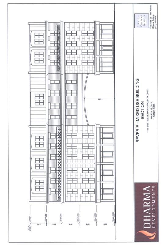
MIXED-USE BUILDING SECTION DOCUMENT 7