Report
to/Rapport au :
Comité de l'urbanisme
24 June 2011 / le 24 juin 2011
Submitted by/Soumis
par : Nancy Schepers, Deputy City
Manager,
Directrice municipale adjointe, Infrastructure
Services and Community Sustainability, Services d'infrastructure et Viabilité des
collectivités
Contact Person/Personne-ressource : Richard Kilstrom,
Manager/Gestionnaire,
Policy Development
and Urban Design/Élaboration de la politique et conception urbaine, Planning
and Growth Management/Urbanisme et Gestion de la croissance
Élaboration de la
politique et conception urbaine
(613) 580-2424
x22653, Richard.Kilstrom@ottawa.ca
|
SUBJECT: |
|
|
|
|
|
OBJET : |
PHASE 2 DE L’AUDIENCE DE LA COMMISSION DES AFFAIRES
MUNICIPALES DE L’ONTARIO (CAMO) CONCERNANT LA LIMITE URBAINE |
REPORT RECOMMENDATION
That Planning Committee approve the process outlined in Document 1 for establishing Council’s position on lands to be added to the Urban Area.
RECOMMANDATION DU
RAPPORT
Que le Comité de
l'urbanisme approuve le processus exposé dans le
Document 1, visant à établir la position du Conseil relativement aux terrains
qui doivent être ajoutés au secteur urbain.
BACKGROUND
As part of the Official Plan review completed in June 2009, Council decided to add 230 hectares of land to the urban boundary. That decision was appealed to the Ontario Municipal Board (OMB). The Board agreed to deal with the urban expansion decision in two phases; Phase 1 on how much land should be added, and Phase 2 on where any land to be added should be located. On June 3, 2011 the Board’s decision on the first phase “how much land” was released which concluded that a total of 850 hectares of land should be added.
A date for Phase 2 of the OMB hearing is still to be set. The purpose of this report is to:
1.
Set out the
process for Council to decide its position on what lands should be added for
the 850 hectares;
2.
Advise
Committee of the May 2009 staff recommendation on what lands should be added;
and
3.
Advise
Committee of the May 2009 staff recommendations on related policy changes to
the Official Plan.
DISCUSSION
Council added 230 hectares of urban land through Official Plan Amendment No. 76 (OPA 76), adopted in June 2009. Of the 230 hectares, 163 hectares were subsequently confirmed through Amendment 77, which is now in effect. Consequently, the OMB decision requires that an additional 687 hectares be added for a total of 850 hectares.
The Board determined in its decision that the process and methodology used by the City in establishing the population projection, converting population to housing, and housing needs to land supply was sound. The Board also recognised that the City’s process was transparent and open to public scrutiny with numerous opportunities for public and landowner input.
Concurrently with that process, staff also undertook a comprehensive and comparative analysis of potential areas for urban expansion. That analysis considered the City’s land use policy framework, direction in the Provincial Policy Statement, and the capability of sites to integrate with existing communities and utilise existing and planned capacity in City infrastructure and other services. The top ranked areas that provided the required amount of land were identified as part of the staff recommendations to the joint Planning and Environment and Agriculture and Rural Affairs Committees in May 2009.
Staff considers that this foundation of work and the Board acknowledgement of its robustness should not be ignored. Therefore, subject to review of any new information that may be submitted, the analysis undertaken for the 2009 OP review should form the basis of the City’s position at the “where” phase of the urban boundary hearing.
Document 1 – Recommended Process.
The process recommended to determine the City’s position at the Phase 2 hearing.
Document 2 - Lands proposed in 2009 be added to the urban boundary.
This describes the parcels recommended in May 2009 be added to the Urban Area.
Document 3 – Proposed policy changes to the Official Plan related to urban land additions.
This sets out Official Plan policies proposed in 2009 for lands to be added to the Urban Area.
RURAL IMPLICATIONS
It was agreed by all parties to the hearing, in determining the allocation of city-wide population growth, to accept the nine per cent assignment of dwelling units and 10 per cent assignment of population growth to the rural area.
CONSULTATION
Public consultation will be undertaken as part of the process leading up to the September 13 meeting of Planning Committee.
COMMENTS BY THE WARD COUNCILLOR(S)
N/A
LEGAL IMPLICATIONS
As outlined in the accompanying report on the outcome of the Urban Boundary Phase 1 hearing, the Ontario Municipal Board noted with approval the process that led up to the adoption of Official Plan Amendment 76. While the Phase 1 hearing did not require the Board to comment upon the location of the lands to be added to the Urban Area, it would be expected that the staff report to Committee in September would only need to address aspects of proposed additions that were not known at the time of the preparation of the staff report to the Joint Committee in May, 2009.
RISK MANAGEMENT IMPLICATIONS
N/A
FINANCIAL IMPLICATIONS
There are no direct financial implications associated with this report.
ENVIRONMENTAL IMPLICATIONS
The environmental aspects of the candidate parcels for addition to the Urban Area were analyzed as part of the process prior to the adoption of OPA 76. Proposed policies in the amendment provide for natural heritage system lands in each area to be transferred to the City for $1.
TECHNOLOGY IMPLICATIONS
N/A
CITY STRATEGIC PLAN
This report supports Planning and Growth Management priorities to manage growth and create sustainable communities and to ensure that the City infrastructure required for new growth is built or improved as needed to serve that growth.
SUPPORTING DOCUMENTATION
Document 1 Recommended Process
Document 2 Lands proposed in 2009 be added to the urban boundary
Document 3 Proposed 2009 Policy changes to the Official Plan related to urban land additions
DISPOSITION
RECOMMENDED PROCESS DOCUMENT
1
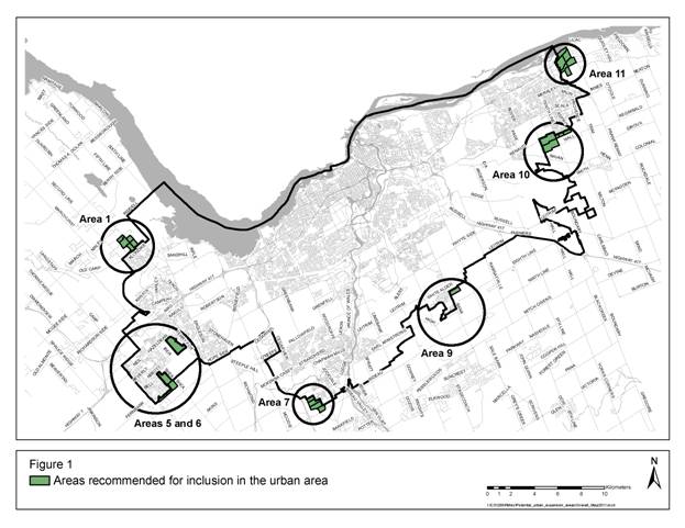
In detail, the following schedules show each of the expansion areas recommended by staff in the draft amendment.
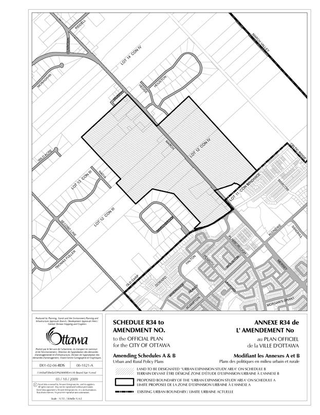
Schedule R34: Kanata North (Area 1 parcels)
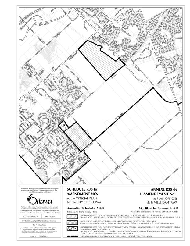
Schedule R35: Fernbank CDP lands (Area 5, now part of approved Urban Area)
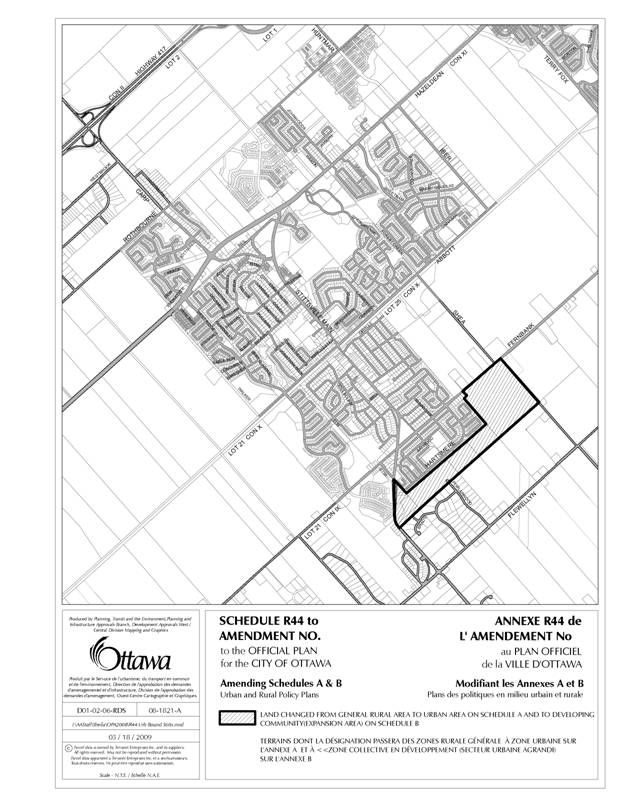
Schedule R44: South of Stittsville (Area 6 parcels)
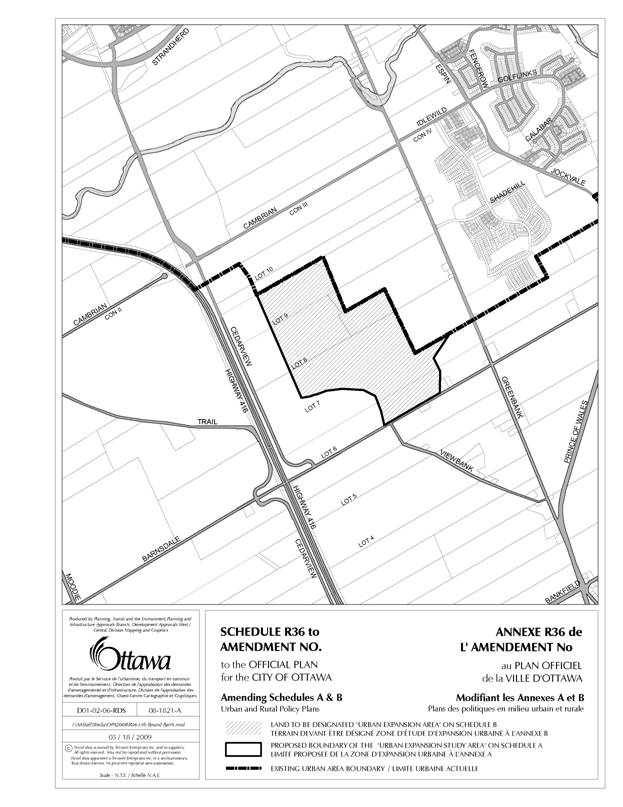
Schedule R36: South of Barrhaven (Area 7 parcels)
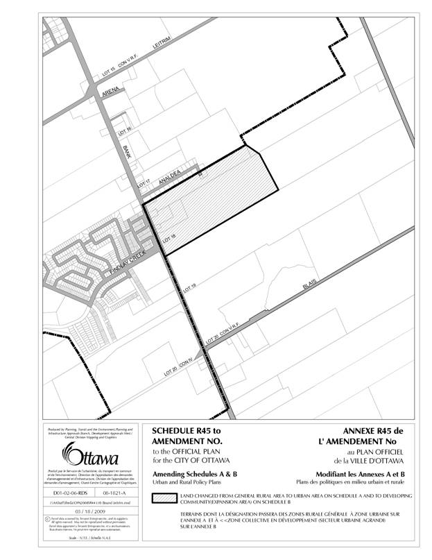
Schedule R45: Leitrim (Area 9 parcel)
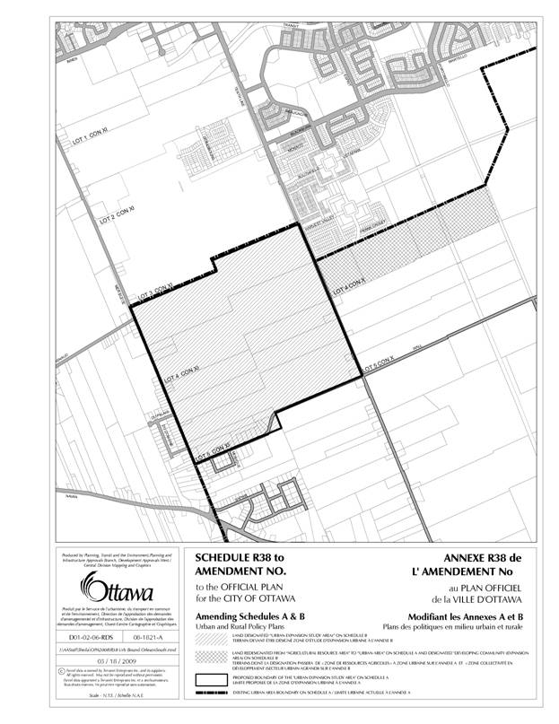
Schedule R38: South of Orleans (Area 10 parcels)
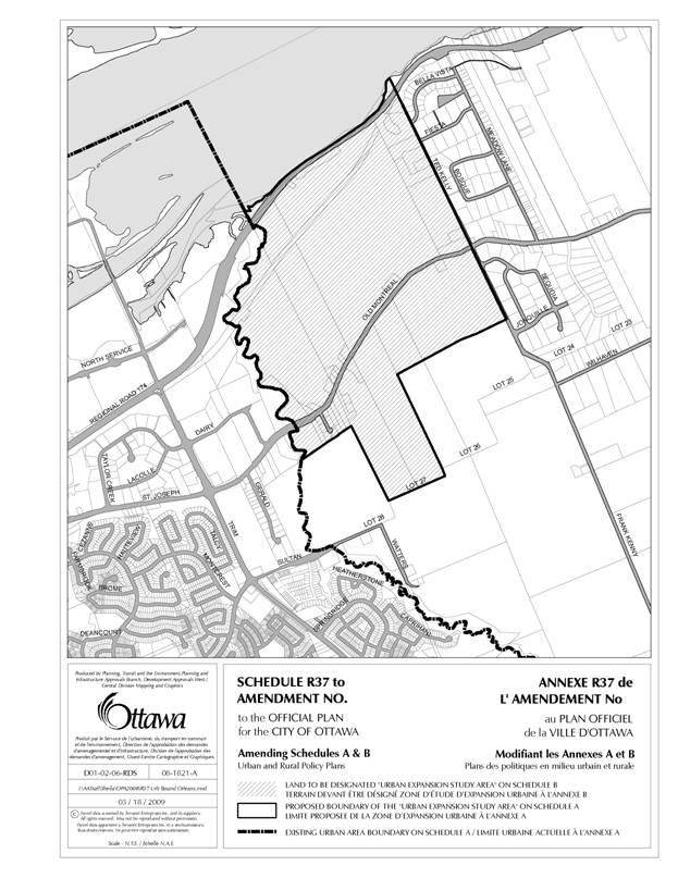
Schedule R37: East of Orleans (Area 11 parcels)
The analysis of parcels involved scoring each parcel by a detailed set of criteria that was subject to public consultation and revision. Because of the different sizes of each parcel it was not possible to arrive at a total of exactly 850 hectares. The list of parcels recommended for inclusion as Urban Area stopped at the point closest to a total of 850 hectares. The recommended parcels totalled 842.6 developable hectares, as shown in Figure 2. It should also be noted that because this is developable land (i.e. excluding environmental land and other non-developable constraint land) that the total amount of land is approximately 1,006 hectares.
Figure 2. Parcels recommended for urban additions by staff in 2009
|
Area |
Gross
Developable Ha |
Cumulative
Developable Ha |
Point
Score |
|
5a |
105.2 |
105.2 |
71 |
|
10a |
78.7 |
183.9 |
67 |
|
11a |
45.7 |
229.6 |
64 |
|
6a |
35.0 |
264.6 |
63 |
|
11c |
9.9 |
274.5 |
63 |
|
5b |
57.7 |
332.1 |
62 |
|
10d |
8.3 |
340.5 |
61 |
|
7b |
35.6 |
376.1 |
58 |
|
11e |
16.9 |
393.0 |
58 |
|
7d |
27.1 |
420.1 |
57 |
|
11d |
39.3 |
459.5 |
57 |
|
7c |
39.5 |
499.0 |
56 |
|
10e |
19.9 |
518.9 |
56 |
|
11b |
33.2 |
552.1 |
55 |
|
1bW |
26.0 |
578.0 |
54 |
|
6b |
12.3 |
590.3 |
54 |
|
1h |
15.6 |
605.9 |
52 |
|
1a |
25.9 |
631.8 |
51 |
|
1d |
43.5 |
675.3 |
51 |
|
6c |
19.8 |
695.2 |
51 |
|
10b |
79.8 |
775.0 |
51 |
|
11h |
11.8 |
786.8 |
51 |
|
1cW |
18.7 |
805.5 |
50 |
|
9a |
37.1 |
842.6 |
50 |
Removing the 163 hectares of land in the Fernbank CDP area that is now urban (OPA 77), the total recommended addition from the 2009 analysis is approximately 680 developable hectares.
Staff will review the information used in the parcel scoring done in 2009 to identify whether any new information has become available since May 2009 that could affect the evaluation and will also review any submissions of new information received until August 12. Any revisions to the parcel scores and recommended parcels will be presented to the Planning Committee meeting of September 13.
·
A Future
Urban Area designation would apply to land in the Fernbank Community Design
Plan (CDP) shown on Figure 1 in Document 1. As noted, these lands were added to
the urban area through Amendment 77. Since it is in legal effect this
designation is no longer required.
·
An Urban Expansion Study Area designation
would apply to areas which are larger than the others and more complex to plan.
This designation was removed from OPA 76 because the lands to which it applied
were not part of the 230 ha added by Council. However the OMB decision
reinstates policy 3.12 from draft OPA 76, which is as follows:
“3.12
– Urban Expansion Study Area
The designation of Urban
Expansion Study Area on Schedule B contributes to the provision of sufficient
urban land to support the residential demands of the projected population to
2031. These lands will develop primarily for residential purposes, although
minor, non-residential uses to meet the needs of a neighbourhood may also be
located here. A comprehensive study will be required prior to bringing these
lands into the urban area.
1.
Lands
are designated on Schedule B as ‘Urban Expansion Study Area’ with the intent
that these lands will be evaluated for development primarily for urban
residential uses, once the policies of this section have been satisfied. An
Official Plan amendment will be required to provide a General Urban Area
designation. The amendment may also be required to implement infrastructure,
environmental and open space provisions of plans approved for individual areas.
2.
The
type of study and development plan required to achieve the policies of this
section will be agreed to in advance and may be a community design plan or a
concept plan. Either process will require a comprehensive consultation process
with the community to identify issues and potential solutions.
3.
Where
the development plan impacts multiple landowners, it is their responsibility to
collaborate on the preparation of the plan and to agree on how parks,
stormwater ponds and any other facilities will be located and costs shared. The
City will require a landowners’ agreement addressing these matters prior to the
review of development applications.
4.
Proponents
of development will complete, to the satisfaction of the City, studies and a
plan of sufficient detail to:
a)
Identify
the location, timing and cost of roads and transit facilities, water and
wastewater services, public utilities, stormwater management facilities, etc.
required on-site and off-site to service the area; and
b)
Identify
the natural heritage system on the site independent of the potential
developable area. Typically an environmental management plan as described in
Section 2.4.2 will be prepared where a subwatershed study does not exist or
does not provide sufficient guidance to identify the environmental features on
the site and their functions, which together constitute the natural heritage
system. The components of this system are generally described in Section 2.4.2,
with the exception that significant woodlands are to be further evaluated
consistent with the Urban Natural Areas Environmental Evaluation Study. No
development is permitted within this system, which is to be conveyed to the
City for public use before development of the area is approved; and
c)
Identify
Recreational Pathways on the site; and
d)
Evaluate
the adequacy of community facilities existing or planned for the area in
consultation with School Boards and other providers of community facilities;
e)
Show how
the plan will achieve other policies of this Official Plan including, but not
limited to, housing mix and densities and affordable housing; and
f)
Meet
the requirements of Phase 1 and 2 of the Environmental Assessment Act
where required.
5.
Proponents
of development will prepare a Financial Implementation Plan and commit to
providing:
a)
The
on-site and off-site servicing systems described above through development
charges or at the expense of the developer; and
b)
The
natural heritage system as non-developable lands to be transferred to the City
for $1; and
c)
The
Recreational Pathways as identified in this Plan through development charges or
at the expense of the developer.”
Urban Expansion
Study Area designation lands would
be shown on Schedule B. They would not be designated on Schedule A but
identified in outline. During consultation, the community, the developer and
the City would identify any requirements that must be met before development
proceeds along with all other study requirements of policy 3.12. The requirement
for a subsequent Official Plan amendment allows for additional consultation and
public meetings to resolve issues. The three areas proposed in 2009 for this
designation were north of Kanata (in Document 2, Area 1 on Figure 1 and Schedule
R34), Barrhaven South (Area 7 and Schedule R36), east of Orleans (Area 11 and Schedule
R37) and south of Orleans (west part of Area 10 and Schedule 38).
- A Developing Community (Expansion Area)
designation would apply to smaller less complex parcels. This was policy
3.13 in draft OPA 76, and policy 3.12 in the amendment adopted by Council.
It states:
“3.13 - Developing Community
(Expansion Area)
The designation of Developing Community
(Expansion Area) on Schedule B and Urban Area on Schedule A contributes to the
provision of sufficient urban land to support the residential demands of the
projected population. These lands, none of which is very large, will develop
primarily for residential purposes, although minor, non-residential uses to
meet the needs of a neighbourhood may also be located here.
1.
Lands
designated on Schedule B as ‘Developing Community (Expansion Area)’ and ‘Urban
Area’ on Schedule A contribute to the provision of sufficient urban land to
support the residential demands of the projected population to 2031. The intent
is that these lands will be developed primarily for urban residential uses,
once the policies of this section have been satisfied.
2.
The
policies of this section will be achieved through the preparation of a plan of
subdivision.
3.
Proponents
of development will complete, to the satisfaction of the City, studies and a
plan of sufficient detail to:
a) Identify the location, timing and cost of
roads and transit facilities, water and wastewater services, public utilities,
stormwater management facilities, etc. required on-site and off-site to service
the area; and
b) Identify the natural heritage system on the
site independent of the potential developable area. Typically an environmental
management plan as described in Section 2.4.2 will be prepared where a
subwatershed study does not exist or does not provide sufficient guidance to
identify the environmental features on the site and their functions, which
together constitute the natural heritage system. The components of this system
are generally described in Section 2.4.2, with the exception that significant
woodlands are to be further evaluated consistent with the Urban Natural Areas
Environmental Evaluation Study. No development is permitted within this system,
which is to be conveyed to the City for public use before development of the
area is approved; and
c) Identify Recreational Pathways on the site;
d) Show how the plan will achieve other
policies of this Official Plan including, but not limited to, housing mix and
densities and affordable housing; and
e) Meet the requirements of Phase 1 and 2 of
the Environmental Assessment Act where required.
4.
Proponents
of development will prepare a Financial Implementation Plan and commit to
providing:
a) The on-site and off-site servicing systems
described above through development charges or at the expense of the developer;
and
b) The natural heritage system as
non-developable lands to be transferred to the City for $1; and
c) The Recreational Pathways as identified in
this Plan through development charges or at the expense of the developer.
5.
An amendment to this Plan will not be required to remove the designation
of Developing Community (Expansion Area) and replace it with General Urban
Area, but an amendment may be required to implement infrastructure and open space
provisions of plans approved for individual areas. Development may proceed once
the City is satisfied that the requirements of this section have been met and
the City has approved the plan of subdivision.”
The
policy does not require an Official Plan amendment to develop these lands, but proponents
would still be required to complete all the identified studies to the
satisfaction of the City before development proceeds. It is expected that
informal consultation will occur along with the formal public meeting
associated with a plan of subdivision. The three areas with this designation
were proposed to be south of Stittsville (in Document 2, Area 6 and Schedule
R44), in Leitrim (Area 9 and Schedule R45) and other areas south of Orleans (east
part of Area 10 and Schedule R38).