5. Hazeldean Road Widening - (Terry
Fox Drive To Carp Road) Environmental
Assessment Study
Élargissement du chemin Hazeldean – (de la promenade
Terry-Fox au chemin Carp) – Étude d'évaluation
environnementale
Committee Recommendation
That Council approve:
1.
The finalization
and filing of an Environmental Study Report (ESR) for the widening of Hazeldean
Road between Carp Road and Terry Fox Drive as detailed herein.
2.
The inclusion of
the identified unequal widening requirements for the section of Hazeldean Road
from approximately Savage Drive east to Terry Fox Drive in the appropriate
Schedule(s) of the new City of Ottawa Official Plan.
Recommandation du comitÉ
Que le Conseil
municipal approuve :
1.
le parachèvement et le dépôt d’un
rapport d’étude environnementale en vue de l’élargissement du chemin Hazeldean
entre le chemin Carp et la promenade Terry-Fox, tel qu’il est mentionné aux
présentes;
2.
l’inclusion des exigences
d’élargissement inégal établies pour le tronçon du chemin Hazeldean, de la
promenade Savage à la promenade Terry-Fox environ, dans le(s) annexe(s)
appropriée(s) du nouveau Plan directeur de la Ville d’Ottawa.
Documentation
1. General Manager, Development Services report dated 28 February 2002 is immediately attached (ACS2002-DEV-POL-0008).
2. Katimavik-Hazeldean Community Association letter dated 16 March 2002 is held on file.
Report to/Rapport au:
Transportation and Transit Committee/
Comité des transports et des
services de transport en commun
and Council/et au Conseil
28 February 2002 / le 28
février 2002
Submitted by/Soumis
par: Ned Lathrop, General Manager/Directeur général
Development Services Department
/ Services d’aménagement
Contact/Personne-ressource: Vivi Chi, Manager, Transportation and Infrastructure Gestionnaire, transports et l’infrastructure
580-2424,
ext. 21877, vivi.chi@city.ottawa.on.ca
|
|
|
Ref N°: ACS2002-DEV-POL-0008 |
SUBJECT: HAZELDEAN ROAD WIDENING - (TERRY FOX DRIVE
TO CARP ROAD) ENVIRONMENTAL ASSESSMENT STUDY
OBJET: ÉLARGISSEMENT DU CHEMIN HAZELDEAN – (DE LA PROMENADE
TERRY-FOX AU CHEMIN CARP) – ÉTUDE D'ÉVALUATION ENVIRONNEMENTALE
REPORT RECOMMENDATIONS
That the Transportation and Transit Committee recommend Council
approve:
3.
The finalization
and filing of an Environmental Study Report (ESR) for the widening of Hazeldean
Road between Carp Road and Terry Fox Drive as detailed herein.
4.
The inclusion of
the identified unequal widening requirements for the section of Hazeldean Road
from approximately Savage Drive east to Terry Fox Drive in the appropriate
Schedule(s) of the new City of Ottawa Official Plan.
RECOMMANDATIONS DU RAPPORT
Que le Comité des transports et des
services de transport en commun recommande au Conseil municipal
d’approuver :
1.
le parachèvement et le dépôt d’un
rapport d’étude environnementale en vue de l’élargissement du chemin Hazeldean
entre le chemin Carp et la promenade Terry-Fox, tel qu’il est mentionné aux
présentes;
2.
l’inclusion des exigences
d’élargissement inégal établies pour le tronçon du chemin Hazeldean, de la
promenade Savage à la promenade Terry-Fox environ, dans le(s) annexe(s)
appropriée(s) du nouveau Plan directeur de la Ville d’Ottawa.
BACKGROUND
The former Region of Ottawa-Carleton's Official Plan (ROP) and Transportation Master Plan (TMP), adopted in July 1997, identified several transportation projects that are required by 2021 to serve the significant projected growth in both population and employment in the Kanata and Stittsville area.
The TMP identified the Hazeldean Road widening as a “Key Infrastructure Project for Phase 1 Development” and listed it as a priority to be implemented by 2006. The former Township of Goulbourn Official Plan (1996) also identified a widened Hazeldean Road as an important future local infrastructure improvement.
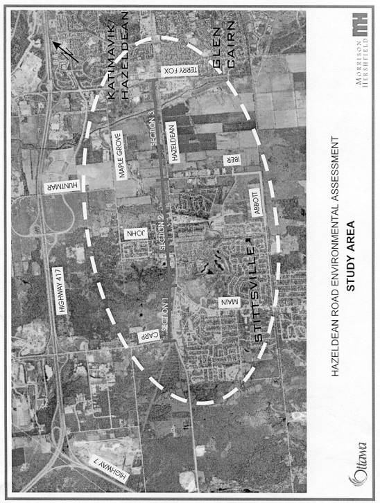
In order to meet the commitments made in the ROP’s Regional Development Strategy, the Environmental Assessment (EA) study for the widening of Hazeldean Road from Carp Road to Terry Fox Drive was started in November 2000. The study area is illustrated in Annex A.
The EA study examined the 4.4 km section of Hazeldean Road from Carp Road to Terry Fox Drive. Three distinct sections were identified along the corridor:
|
Section |
West Limit |
East Limit |
Length |
|
1 |
Carp Road |
Main Street |
0.9 km |
|
2 |
Main Street |
Iber Road |
1.8 km |
|
3 |
Iber Road |
Terry Fox Drive |
1.7 km |
DISCUSSION
Existing Conditions
The section of Hazeldean Road from Carp Road to Terry Fox Drive is part of a significant east-west corridor linking the former municipalities of Stittsville, Kanata, Nepean and Ottawa. The area has been undergoing rapid growth in development and the resulting traffic volumes have been increasing steadily. Sections of the existing two-lane rural arterial Hazeldean Road are currently operating at or near capacity during peak periods.
Pedestrians are not accommodated along the existing Hazeldean Road as there are no sidewalks. Cyclists must use either the on-road vehicle lanes or the gravel shoulder adjacent to the ditch. There are also operational and potential safety concerns due to the number of uncontrolled driveways especially between Main Street and Iber Road. OC Transpo currently operates weekday rush hour buses along Hazeldean Road to service the Stittsville community.
Need
The first phase of the Environmental Assessment (EA) study was to review and confirm the need to widening the existing two-lane rural arterial Hazeldean Road.
The TMP identified the need to widen Hazeldean Road. This need is primarily based on projections for the Kanata area to grow from 35,400 to 90,000 residents between 1991 and 2021 and for the Stittsville area to grow from 8,400 to 22,000 residents over the same time frame. The TMP also provides for growth in employment from 14,400 to 44,400 jobs in the combined Kanata-Stittsville area between 1995 and 2021. Further increases in growth beyond what was planned for in the TMP are expected as a result of the implementation of the Kanata West Business Park through Regional OP Amendment 9 (ROPA 9) and changes in growth projections as adopted by Council on 12 October 2001.
Traffic forecasts were prepared as part of the EA to determine the future needs along the Hazeldean Road corridor. Consistent with the objectives of the TMP, the travel demand forecasting component of the EA study assumed that alternative solutions to reduce infrastructure needs and travel demands were in place prior to confirming the need to widen the roadway. These alternatives included the optimization of the existing roadway network, increased vehicle occupancy and increased modal share for cycling, walking and transit trips.
The traffic volume projections supported the need for the following roadway capacity improvements along Hazeldean Road:
· Section 1 - Carp Road to Main Street – maintain existing 2-lane cross-section and provide other operational improvements.
· Section 2 - Main Street to Iber Road - widen to 4 lanes.
· Section 3 - Iber Road to Terry Fox Drive - widen to 4 lanes and protect for future widening to 6 lanes (for HOV/Bus-only Lanes for instance), if required.
Upgrading Hazeldean Road will provide an opportunity to improve the quality of service for all modes of transportation considered within the ROP and TMP addressing, in particular, needed improvements for pedestrians and cyclists.
Design Criteria
Key design criteria used as a baseline in the development of alternatives were derived from the Regional Road Corridor Design Guidelines (July 2000). They included:
·
2.0 m
cycling lanes
·
3.5 m
traffic lanes (3.75 m adjacent to a median)
·
2.0 m
boulevards
· 5.0 m median (including provision for left-turn lanes)
· 2.0 m sidewalks
· 70 km/h design speed (60 km/h posted speed)
For the Section of Hazeldean Road (Main Street to Iber Road), these criteria had to be modified somewhat due to right-of-way constraints and the requirements for a two-way left-turn lane instead of a median.
RECOMMENDED DESIGN
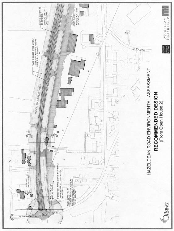
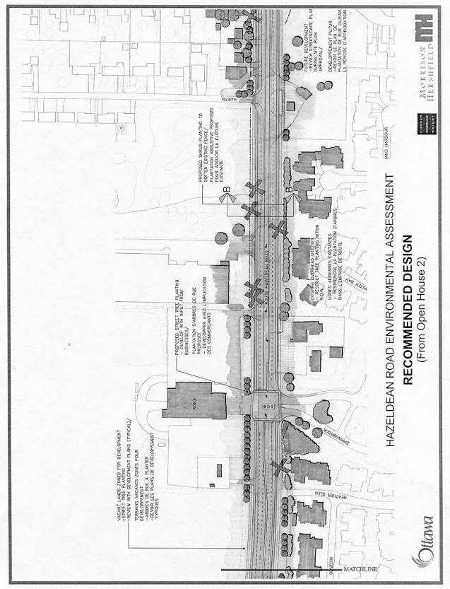
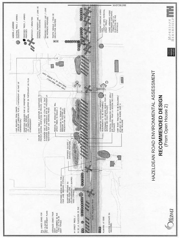
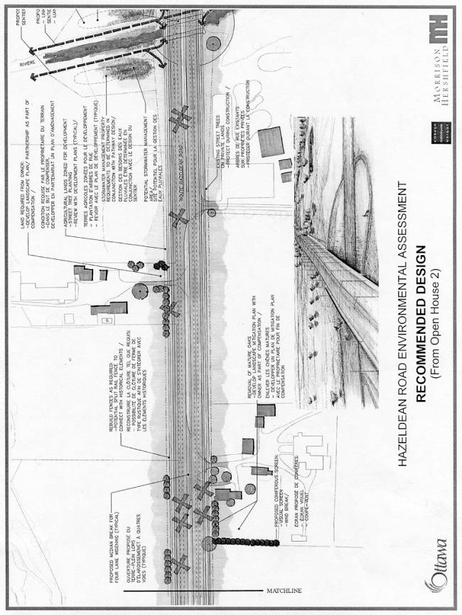
The recommended design for the Hazeldean Road Widening EA including typical sections and plans is illustrated in Annexes B and C.
The design plans show the potential future six-lane roadway between Iber Road and Terry Fox Drive, which was developed to allow appropriate mitigation and implementation planning.
Alternative Design Concepts
Section 1 - Carp Road to Main Street
The needs assessment determined that this section of roadway is generally adequate as a 2-lane roadway to accommodate existing and future vehicular volumes. Somewhat unique is the Sunday-only travel demand associated with the Stittsville Flea Market, which creates operational problems on that day. To accommodate this high volume traffic, various scenarios were considered including maintaining a 2-lane cross-section, adding a turning lane into the parking area to the north and widening with turning lanes between the Stittsville Flea Market and Main Street.
The recommended modifications to Hazeldean Road from Carp Road to Main
Street include providing a south side sidewalk, bicycle lanes, adding turning
lanes, an additional traffic lane in each direction from the Stittsville Flea
Market area to Main Street, lighting and traffic control.
Section 2 - Main Street to Iber Road
The needs assessment determined that this section of roadway should be widened to 4 lanes with left-turn lanes at key intersections. Due to the limited right-of-way and the desire to minimize property impacts, two alignment alternatives were initially developed:
· equal widening on either side of the existing roadway centreline, and
· unequal widening (a shift to the north) for part of the route from approximately Savage Drive to Iber Road in order to minimize impacts (including potential removal or relocation of the heritage-designated Kemp’s Restaurant building).
There were also several median alternatives considered which included no median, raised median, mountable median and a two-way left-turn lane.
The recommended modifications to Hazeldean
Road from Main Street to Iber Road involve widening the road from a 2-lane
rural road to a 4-lane urban arterial including sidewalks, bicycle lanes, turn
lanes, landscaping, lighting and traffic control. A two-way left turn lane is recommended from Springbrook Drive to
Cedarow Court. The centerline will be shifted to the north in the vicinity of
the Kemp Restaurant.
Section 3 - Iber Road to Terry Fox Drive
The needs assessment determined that this section of roadway should be widened to 4 lanes with provision for an ultimate 6-lane cross-section. Two alignment alternatives were initially developed:
· equal widening on either side of the existing centreline, and
· unequal widening (a shift to the north) in order to minimize impacts.
Several median alternatives were also considered which included no median, raised median, a mountable median, a two-way left turn lane, and an extra wide median (proposed through the Public Advisory Committee as a means to reduce loss of trees and to create a distinctive ‘parkway’ east-west transition zone).
The recommended modifications to Hazeldean Road from Iber Road to Terry Fox Drive involve shifting the centerline to the north and widening the road from a 2-lane road to a 4-lane divided urban arterial (with protection for future widening to 6 lanes) including sidewalks, bicycle lanes, turn lanes, landscaping, lighting and traffic control.
Carp River Crossing
The existing Hazeldean Road / Carp River culvert will require replacement when Hazeldean Road is widened. Both the former ROP and ROPA 9 identify the Carp River as a recreational corridor. The EA study considered how to accommodate planned future recreational facilities along the Carp River at Hazeldean Road. The Technical Advisory Committee, City staff responsible for pedestrian, cyclist and recreational planning issues and those involved in the Carp Subwatershed and Kanata West lands studies provided comments and input on various options including underpass, overpass or at-grade crossings.
The recommended alternative is to construct a new bridge crossing of
the Carp River, accommodating a grade-separated underpass for recreational
pathways along both the east and west sides of the Carp River.
Major Issues
Heritage
There are 5 homes dating from the mid to late nineteenth century along the corridor. The original Kemp’s Tavern, which was built of stone in 1868 adjacent to Poole Creek and survived the ‘great fire’ of 1870, is the only designated heritage site along the corridor and is situated close to the existing Hazeldean Road. Also close to the roadway is a two-storey brick home, located west of the Carp River and likely constructed in the late 1800’s, which is considered of heritage significance and a prominent local landmark. Local residents emphasized the importance of maintaining the historic character of the corridor during the EA study.
The recommended alternative
recognizes the importance of these buildings and has been designed so that the
buildings are not affected by the road widening.
Aesthetics/Landscaping
Preserving the existing tree canopy along the corridor as well as maintaining a buffer zone between Stittsville and Kanata were major concerns of the public.
A concept plan was developed during the EA study to demonstrate recommended mitigation measures and potential enhancements to the visual appearance of the corridor. This plan included landscaping measures in response to loss of vegetation, ‘gateway’ treatments such as median plantings and ‘roadway level’ heritage architectural features at the Poole Creek and Carp River bridge crossings.
Recommendations related to landscaping include ‘pre-stressing’ remaining trees, pre- and post-construction planting and exploring of opportunities for selected tree relocations as well as planting trees on private property in partnership with adjacent landowners where public right-of-way is insufficient.
Fish Habitat
There are several watercourse crossings within the study corridor that have been classified as fish habitat. These are the Carp River, the Carp River Tributary, Poole Creek, and Poole Creek Tributary. Of these, only Poole Creek is classified as a cool water resource.
During construction, the appropriate mitigation and rehabilitation measures will be in place at all of the water crossings. In addition, it is recommended that compensation for loss of fish habitat for the watercourse crossings (as required by the Fisheries Act) be combined at Poole Creek to maximize protection and enhancement of this unique cool water fish habitat. The details of the mitigation, rehabilitation and compensation will be established during the design stage and will be developed in conjunction with recommendations of the Carp River Watershed/Subwatershed Study. These details will include best practices and construction prohibitions during fish spawning seasons.
Stormwater Management
Stormwater management was also identified as an issue. Stormwater management facilities are recommended at several locations to control runoff volumes, erosion and water quality. Design of these facilities will require further investigation and liaison with approving agencies to provide solutions that meet stormwater management objectives.
Opportunities have been identified to combine stormwater management measures with the requirements of nearby roadway projects and other developments and to explore enhancement of these facilities for recreational uses.
Access To / From Hazeldean Road
Although a two-way left turn lane is recommended between Springbrook Drive and Cedarow Court to accommodate full access requirements, there would be 5 residences and businesses located adjacent to intersections between Main Street and Iber Road that would need to be limited to right-in/right-out access.
For the proposed 4-lane widening between Iber Road and Terry Fox Drive, it is recommended that access across the median be provided at most business and residential entrances through turning lanes or short sections of depressed median. The continued appropriateness of these median breaks would need to be reviewed if and when the roadway is to be widened to 6 lanes. It is recommended that access to Kincardine Drive be limited to right-in/right-out access given its close proximity to the Terry Fox Drive intersection.
Traffic Signals at Intersections
There have been several public
requests for new traffic signals at the intersections of Hazeldean Road and with Sweetnam Drive,
Hazeldean Road and with Fringewood Drive and Hazeldean Road and with Main Street. Main Street will warrant signals in the
future and therefore traffic signals are recommended for installation at this
location. Based on the traffic
projections carried out as part of this study, signal warrants are not met for
the other intersections.
Property Impacts
Adequate right-of-way exists between Carp Road and Main Street for the proposed roadway upgrades as well as for future widening to four lanes, if ever required. There would be minor property impacts on both sides of the roadway between Main Street and Iber Road requiring acquisition of relatively small strips of property from the abutting landowners. The property acquisition requirements from Iber Road to Terry Fox Drive would be limited to a continuous strip on the north side of the right-of-way.
Some additional property outside the roadway right-of-way requirements would need to be acquired in the areas of the 4 watercourse crossings for potential stormwater management facilities.
Cut-Through Traffic
Residents of John Street expressed concerns that construction-related traffic delays on Hazeldean Road could encourage non-local traffic to use John Street/Maple Grove Road as a means to bypass the areas under construction. Also, there is concern with respect to current cut-through traffic.
The recommended design permits construction staging that reduces the impacts to the local community by maintaining a high level of service on Hazeldean Road. The recommended 4.0 m northerly shift of the roadway centreline over most of the project allows constructing most of the new westbound lanes ‘clear of’ the existing roadway traffic. The new westbound lanes would then be used for two-way traffic, while the new eastbound lanes are constructed, also ‘in the clear’.
With respect to the current traffic problems on John Street, the Mobility Management and Neighbourhood Studies section initiated a traffic calming exercise. The recommendations are in the process of being implemented.
Noise
There have been numerous concerns brought forward by local residents regarding both existing and future noise levels along the corridor. Noise projections conducted as part of the EA study indicate that there would be increased levels of noise as a result of the proposed roadway widening. However, new noise barriers adjacent to existing residential developments are not warranted within the project limits according to the noise guidelines utilized by the former Region of Ottawa-Carleton for arterial roadway widening projects. In addition, the extent of existing frontages and the numerous access points along Hazeldean Road limit the practicality and effectiveness of noise barriers along most of the developed portion of the corridor.
Residents of the Amberwood Village community, whose homes back onto Hazeldean Road west and east of Springbrook Drive (extending approximately 250 m in each direction), have noted that noise levels have steadily increased in recent years. Some have commented that the installation of traffic signals at Springbrook Drive has exacerbated the noise levels.
The EA study’s noise analysis (which is based on the increase predicted between the ‘with project’ and ‘with-out project’ conditions ten years after construction) indicates that noise attenuation walls are not warranted. However, given the steady increase in noise that has been experienced in the past with the predicted effects caused by the widening of Hazeldean Road, unwarranted noise walls (typically characterized as ‘Privacy Fences’) are recommended in this area in accordance with the former Region’s Noise Control Guidelines for New Construction, Reconstruction and Widening of Regional Roads and Transitways.
Hydro
The existing Hydro pole lines along Hazeldean Road must be relocated when the roadway is widened. Some stakeholders have suggested that the lines should be buried, for at least part of the corridor, to improve aesthetics – this would be similar to the approach taken on Stittsville’s Main Street.
However, burying the Hydro lines could cost up to six times more than relocating the lines above ground. The study team recommends that the issue of burying the Hydro lines be re-examined during the detailed design in light of future City of Ottawa policies addressing utility relocations.
Transit/HOV
Transit as an alternative mode of transportation is a preferred solution to transportation demand as indicated by the aggressive transit modal split objectives in the TMP and ROP. The study area is currently served by on-road OC Transpo bus service and by the Stittsville Shuttle Service.
The TMP includes a future rapid transit extension along Highway 417 to Huntmar Road. The Kanata West lands study has presented concepts for long-term extension of rapid transit south of Highway 417 through the Kanata West lands that could eventually cross Hazeldean Road west of the Carp River.
Discussions early in the project with OC Transpo indicated that rapid transit is not currently considered a solution to transportation needs along the Hazeldean Road corridor. However, it is recommended that a possible future widening of the section of Hazeldean Road between Iber Road and Terry Fox Drive from 4 to 6 lanes consider the potential use of those additional lanes for either bus-only or high-occupancy vehicle (HOV) lanes.
ENVIRONMENTAL IMPLICATIONS
Effects on the environment (Natural, Social, Economic, Cultural, Transportation, etc.) were comprehensively evaluated as part of the EA study.
The most notable effects of the project would be the impacts to existing vegetation, the watercourse crossings and fish habitat, the need to acquire property for the right-of-way and the increase in traffic. The recommended design includes appropriate mitigation to minimize environmental effects.
The widening and reconstruction of Hazeldean Road would provide various positive effects (e.g. sidewalks, cycling lanes and street lighting) and would also alleviate existing and future traffic congestion. The proposed mitigation measures at the Poole Creek watercourse crossings would enhance its unique cool water fish habitat.
RURAL IMPLICATIONS
There is an operating farm located within the corridor limits. The roadway design incorporates median breaks to allow general access and the owner’s occasional need to move farm equipment across Hazeldean Road.
CONSULTATION
There is strong public support for the widening of Hazeldean Road.
The Hazeldean Road project has been conducted in accordance with the Municipal Class Environmental Assessment (June 2000) as a Schedule C project. During the course of the study, regular update meetings were held with a Technical Advisory Committee (TAC) and a Public Advisory Committee (PAC) to seek input, direction and concurrence on the study findings and recommendations.
PAC meetings were held with individuals representing the adjacent communities and businesses. The PAC contact list included the Fringewood Community Association, the Fringewood North Community Association, the Amberway Community Association, the Hazeldean North Community Association, the Stittsville Flea Market, Carleton Condominium Corporation 497 and 548, the Condominium Presidents' Council as well as representatives from other local businesses and the Kanata West lands. Councillors for Ward 4 and Ward 6 were kept apprised of key activities.
In addition to the PAC meetings, two Open Houses were conducted to present the study and its findings to the general public. The first of these was held on May 23, 2001 at which the study process, existing conditions, assessment process, alternative design concepts and next steps were presented for public review and comment. The second and final Open House, held on October 2, 2001, presented the technically preferred alternative, the process undertaken to develop the preferred alternative and the environmental impacts and the proposed mitigation measures for each section of Hazeldean Road. The comments received at the open houses were incorporated, where applicable, into the study.
FINANCIAL IMPLICATIONS
The preliminary cost estimate to undertake the detailed design, acquire property and construct the widening of Hazeldean Road is approximately $25 million (in 2001 dollars). A more accurate total project cost will be developed as detailed design is undertaken.
ATTACHMENTS
Annex A – Study Area
Annex B – Typical Cross-Sections
Annex C – Recommended Design (as presented at the October 2, 2001 Open House)
DISPOSITION
Following Committee and Council approval, the Environmental Study Report (ESR) documenting the entire environmental assessment process and study recommendations will be prepared and filed for a 30-day public review period in accordance with the provincial Environmental Assessment Act.
Once the formal review period is over, and if there are no requests for a Part II Order to the Minister of the Environment (previously known as a request for a “bump-up” to a higher level of study), the project will be considered approved. Pending approved funding, detailed design can be initiated.
The unequal widening requirements for the section of Hazeldean Road from Savage Drive east to Terry Fox Drive will be included in the appropriate schedule(s) of the new City of Ottawa Official Plan.
Study Area Annex A
Typical Cross-Sections Annex B

Recommended Design (as presented at the October 2, 2001 Open House) Annex C