Report to/Rapport au:
Planning and Development
Committee/
Comité
de l’urbanisme de l’amenagement
and
Council/et au Conseil
4 July
2002/le 4 juillet 2002
Submitted
by/Soumis par: Ned Lathrop, General
Manager/Directeur général
Development Services Department
/ Services d’aménagement
Contact/Personne-ressource: Grant Lindsay, Manager, Development
Approvals/ Gestionnaire, Approbation des demandes d’aménagement
580-2424, ext 13242,
Grant.Lindsay@ottawa.ca
|
|
|
Ref N°: ACS2002-DEV-APR-0128 |
SUBJECT: ZONING – 20-50 FRANK NIGHBOR PLACE
OBJET: ZONAGE – 20-50, PLACE FRANK NIGHBOR
REPORT RECOMMENDATION
That the Planning and Development Committee
recommend Council approve an amendment to the former City of Kanata Zoning
By-law 138-93, to rezone 20–50 Frank Nighbor Place from M1C-2(H) and Hazard
Zone – H to M1C-2(H)-f and Hazard Zone – H to add a Flood Fringe Zone and to
alter the existing Hazard Zone.
RECOMMANDATION
DU RAPPORT
Que
le Comité de l’urbanisme et de l’aménagement recommande au Conseil d’approuver
une modification au Règlement municipal sur le zonage 138-93 de l’ancienne
Ville de Kanata, afin de faire passer le zonage du 20-50, place Frank Nighbor
de M1C-2(H) et Zone à risque – H à M1C-2(H)-f et Zone à risque – H, de manière
à ajouter une zone située dans un périmètre d’inondation et à modifier la zone
à risque existante.
BACKGROUND
An application for a zoning by-law amendment was received by the City of Ottawa for 20-50 Frank Nighbor Place in June 2001. The application proposed modifying the extent of the existing hazard land by applying a two-zone approach (incorporating a floodway and a flood fringe) that would permit development to encroach into floodplain of the Carp River as established by the original Zoning By-law.
During the design of both the Corel Centre lands and the Terry Fox Business Park, it was discovered that the elevations around the Carp River are lower than what is shown on the flood plain mapping. As a result, an analysis of the Carp River was undertaken, resulting in a relocated boundary for the extent of the development and filling for both the Corel Centre lands and the Terry Fox Business Park.
Staff reviewed the application and determined that it was premature for the following reasons:
1.
Further
encroachment into the floodplain could jeopardize the findings and
recommendations of the Subwatershed study as it pertains to the Carp River
corridor;
2.
The
two-zone approach should be conducted by the City within the context of the
subwatershed study for the entire reach of the river under urban pressure
(Richardson Side Road to Hazeldean Road).
The Mississippi Valley Conservation Authority
endorsed staff’s position. In addition,
the MVC requested that the City be the proponent of the analysis and zoning
amendment, if supported, to ensure a complete and comprehensive approach was
used.
The applicant agreed to a three-month delay in order
to allow the City to conduct the required analysis through the Carp River
Watershed/Subwatershed Study.
DISCUSSION
The Official Plan for the former City of Kanata sets out policies regarding the implementation of a two-zone flood plain. It is recognized that within in some areas, the flood plain may be suitable for a two-zone approach. This would result in a floodway, which is defined as the area within a flood plain where depths and velocities of flood waters make development unsafe and the flood fringe, which is defined as the area within a flood plain where depths and velocities of flood waters can be safely overcome and development may occur, subject to other policies in the plan.
The Official Plan requires that a site specific Zoning By-law amendment is required where there has been an interest in creating a two-zone flood plain and where the approach is deemed acceptable to the City and the Conservation Authority. The site-specific zoning by-law amendment shall only be passed if:
a) sufficient information is provided to demonstrate that the proposed development and its occupants will be protected from the effects of a 100 year flood;
b) the potential upstream and downstream impacts of the proposal will not significantly alter the hydrology or hydraulics of the flood plain;
c) the underlying designation on Schedule “A” or “B” permits the proposed development;
d) vehicles and people have a safe way of entering and exiting the site during times of flooding.
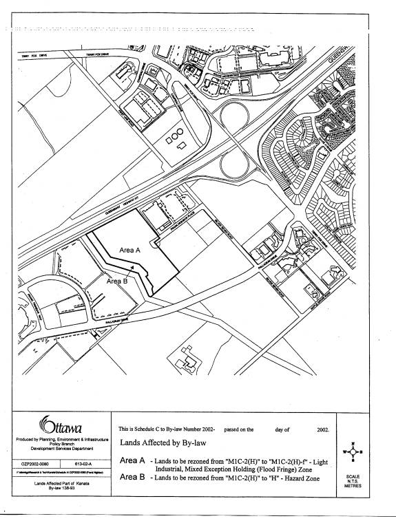
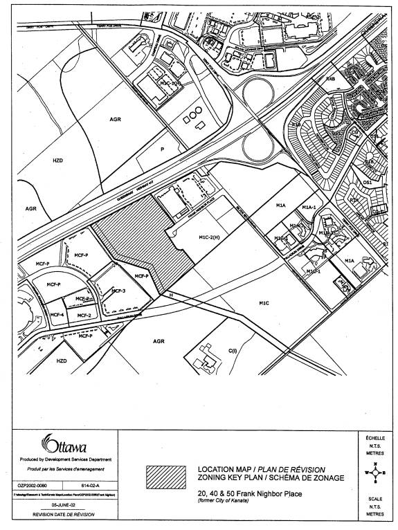
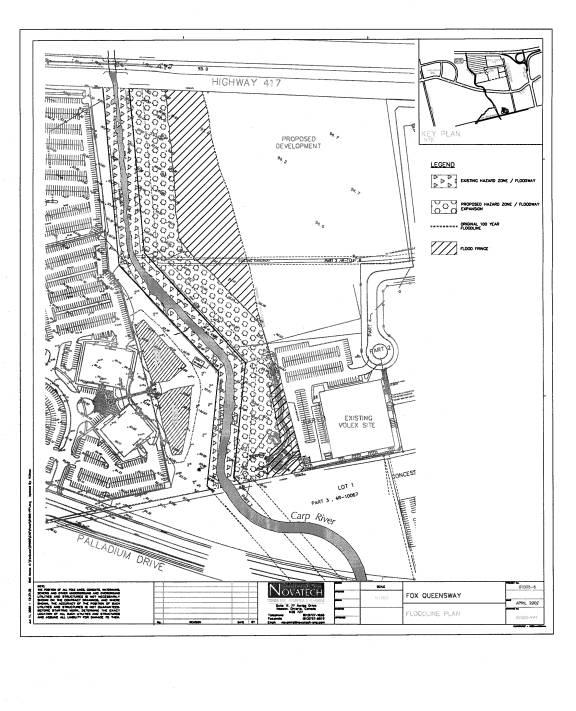
The current zoning for the subject lands east of the Carp River is shown on the Location Plan (Document No. 1). The two-zone flood plain will impact the Light Industrial, Mixed Exception Holding Zone {M1C-2(H)} and the Hazard Zone (H). The creation of the two zone flood plain will result in an increase in the size Hazard Zone, which is reflected on the proposed Zoning Schedule "A"(Document 3). The Hazard Zone will be comprised of the floodway component of the two zone floodplain. The portion of the flood plain to be affected by this change is shown on the Flood Plain map (Document 2).
The holding zone associated with the Light Industrial Mixed area shall only be lifted upon receipt by the City of the following documentation: a traffic study; a market study; a complete site plan application and any other information required by the City. This zone permits industrial uses, business office and big box retail outlets.
ANALYSIS
Carp River Corridor
The
most degraded section of the Carp River is south of Richardson Side Road to its
terminus at the Glen Cairn stormwater facility. This section of the river is characterized as degraded warm water
fisheries. Channelization of the river,
past (agriculture and urbanization) and present land use activities have caused
excessive sediment build-up along the bottom of the channel. Accumulated sediment contributes to degraded
water quality and degraded fish habitat.
An ultimate stable channel form must be achieved under existing and
future land use scenarios.
In terms of 20 and 50 Frank
Nighbor Place, a corridor width of approximately 88-100 metres is
achievable. Development (Corel Centre)
exists along the western portion of this corridor that only provides a 30-metre
setback from the river rather than the desired 50 metres.
Zoning By-law
A comprehensive analysis of the Carp River system and the potential for a two zone for the reach from Richardson Side Road to the Glen Cairn Detention Pond has been conducted. The findings indicate that a two-zone approach can be applied to the subject lands. As a result, the City is now the proponent of this application, with the support of the property owners affected. Application of the two-zone approach along this reach of the Carp River will be done in phases, with the area shown on the Location Map (Document 1) being the first to be implemented. The remaining development parcels along this reach of the River will be pursued through a separate process, as part of the Kanata West Concept Plan and the Carp River Watershed/Subwatershed Study.
The zoning by-law amendment for 20-50 Frank Nighbor Place will contain the following provisions, which will define the two-zone flood plain and provide the framework to permit the development within the flood fringe:
·
Where a zone symbol is followed by a dash and
an “f” (for example M1C-f), this denotes a special zone. The permitted uses and the zone provisions
for the flood fringe zone shall be according to the zone represented by the
zone symbol as well as the following general provisions:
(a)
All permitted uses shall be flood proofed in
accordance with the following provisions:
(i)
any building and related major building
services such as mechanical or electrical services, shall be located at least
0.3 metres above the regulatory flood level.
(ii) all non-residential uses shall be flood proofed to the regulatory flood level.
(b)
All alterations or additions to existing
non-conforming buildings or structures shall be flood proofed in accordance
with the following provisions:
(i)
Alterations or additions which expand the
existing building or structure shall be protected to 0.3 metres above the
regulatory flood level.
In addition to the above-mentioned provisions, the five definitions listed below will be added to Zoning By-law 138-93:
“Flood fringe” means the outer portion of the flood plain between the floodway and the limit of the regulatory flood. Flood depths and velocities are generally less severe in the flood fringe than those experienced in the floodway. The flood fringe is the area where development and site alteration may be permitted.
“Flood plain” means the area, usually low lands, adjoining a watercourse which has been or may be covered by floodwater.
“Floodway” means the channel of a watercourse and the inner portion of the flood plain where flood depths and velocities are generally higher than those experienced in the flood fringe. The floodway represents that area required for the safe passage of flood flow and/or that area where flood depths and/or velocities are considered to be such that they pose a potential threat to life and/or property damage.
“Two-Zone Concept” means the approach whereby certain areas of the flood plain are considered to be less hazardous than others such that development potentially could safely occur. The flood fringe defines that portion of the flood plain where development may be permitted subject to the appropriate flood proofing. The floodway defines that portion of the flood plain wherein development is prohibited or restricted.
“Flood Proofed” means those established technical measures for buildings, structures or properties prone to flooding which are implemented to reduce or eliminate flood damage. Flood proofed non-residential uses and alterations to existing non-conforming uses my incorporate wet passive measures.
The addition of the two-zone
flood plain, whereby part of each affected property will fall within the flood
fringe, will not impact on the permitted uses or the development provisions for
the MIC zone. Any development that will
encroach into the flood fringe of these sites will require flood proofing and approvals
from Mississippi Valley Conservation for fill permits prior to any approvals
being granted by the City. The onus is
therefore on the landowners to ensure that all requirements from Mississippi
Valley Conservation are met or development may not proceed or may be
delayed.
The amendment to Zoning By-law 138-93 to incorporate the two-zone flood plain along the Carp River will include the revised Hazard and the revised floodway, as indicated on the proposed flood plain mapping and zoning schedule (Documents 2 and 3).
ENVIRONMENTAL IMPLICATIONS
The zoning amendment respects the recommendations
forthcoming from the Carp River Watershed/Subwatershed Study. The hazard area was defined based on both
technical (two zone analysis) and environmental considerations. The ecological attributes of the Carp River
corridor are preserved within the dedicated hazard area. The protection of the Carp Corridor will
allow for the future restoration works to occur that will enhance the
environmental features and functions of the river corridor.
CONSULTATION
The affected landowners have been involved with the process of implementing the two-zone flood plain along this portion of the Carp River.
Mississippi
Valley Conservation has been involved with the preparation of this report and
has reviewed the two-zone analysis.
The Ward Councillor is aware of the application.
FINANCIAL IMPLICATIONS
N/A
APPLICATION
PROCESS TIMELINE STATUS
The
application was not processed within the timelines established by the
Department of Development Services. The
application was deemed premature by staff as it was submitted during the
preliminary stages of the Carp River Subwatershed Study that is being
undertaken by the City of Ottawa. This
application was put on hold until such time as the study was well underway and
some conclusions could be determined with regards to allowing a two-zone flood
plain to be permitted along the reach of the Carp River from Richardson Side
Road to the Glen Cairn detention pond.
ATTACHMENTS
Document 1 – Location Map
Document 2 – Flood Fringe/Floodway Map
Document 3 – Proposed Schedule A for Zoning By-law
Amendment
DISPOSITION
Development Services and Legal Services to
co-ordinate the finalization of the Zoning By-law for adoption by Council and
execution by the Mayor and Clerk.
Location Map Document 1
Flood Fringe/Floodway Map Document 2
Proposed Schedule A for Zoning By-law Amendment Document 3