9. reconstruction
de l'avenue holland:
de la rue tyndall à l’avenue carling – modifications proposées à la chaussée |
COMMITTEE
RECOMMENDATION AS AMENDED
That
Council approve the proposed roadway modifications to Holland Avenue, between
Tyndall Street and Carling Avenue as shown in Annexes 2A and 2B, amended
by the following.:
That the
sidewalk portion of the Holland Avenue reconstruction project be designed to
further minimize the “roller coaster” effect by implementing a ramp component
for driveway access based on the Toronto model as a pilot project;
And that staff report to Committee on the design
implications of this model on this project.
Recommandation
MODIFIÉe
du
Comité
Que
le Conseil municipal approuve les modifications proposées à la chaussée de
l’avenue Holland, entre la rue Tyndall et l’avenue Carling, comme l’illustrent
les annexes 2A et 2B, modifiées
par le suivant :.
Que la section du
trottoir du projet de reconstruction de l’avenue Holland soit conçue de
façon à minimiser les cahots en installant une rampe donnant accès à la voie d’accès
pour autos, en s’inspirant du modèle créé dans le cadre du projet pilote de
Toronto.
Et que le personnel
remette un compte rendu au comité sur les répercussions de la conception de ce
modèle de projet.
For
the information of Council
The following motion was referred to the Cycling Advisory Committee:
That the reconstruction include a white line to be painted in the shared facility lane to indicate
the existence of a bicycle lane as has been done on Harbrod and Davenport in Toronto.
Pour la gouverne du Conseil
La motion suivante a été renvoyée au Comité
consultatif sur le cyclisme :
Que cette reconstruction comprenne le tracé d’une
ligne blanche dans la voie des installations partagées afin de marquer la
présence d’une voie cyclable comme on l’a fait à Harbrod et à Davenport, à Toronto.
Documentation
1.
General Manager, Transportation,
Utilities and Public Works
report dated 16 July 2003 (ACS2003-TUP-_TRF-0021).
1.2. Extract of Draft Minutes, 27 August 2003 (To follow).
3. Staff
PowerPoint pPresentation (On file with
the City Clerk.
Report to/Rapport au:
Transportation and Transit Committee/
Comité des transporttransports
et des services de transport en commun
and Council/et au Conseil
16 JulyXXXXXX
July 2003/XXX le
16 juillet 2003XXX juillet
Submitted by/Soumis
par: R.T. Leclair, General
Manager/Directrice générale
Transportation, Utilities and
Public Works/Transport, services et travaux publics
Contact/Personne-ressource: Michael J. Flainek, P. Eng., Director/Directeur
Traffic and Parking
Operations Branch/Circulation et Stationnement
Telephone : 580-2424,
extension 26882, Michael.Flainek@ottawa.ca
|
|
Ref N°: ACS2003-TUP-TRF-0021 |
SUBJECT: Holland
Avenue Reconstruction: Tyndall Street to Carling Avenue – PROPOSED
ROADWAY MODIFICATIONS
OBJET: reconstruction de l'avenue holland: de la rue
tyndall à l’avenue carling – modifications proposées à la chaussée
REPORT RECOMMENDATION
That the Transportation and Transit Committee recommend Council approve the proposed roadway modifications to Holland Avenue, between Tyndall Street and Carling Avenue as shown in Annexes 2A and 2B.
RECOMMANDATIONS
DU RAPPORT
Que le Comité des transports et des
services de transport en commun recommande au Conseil municipal d’approuver les
modifications proposées à la chaussée de l’avenue Holland, entre la rue Tyndall
et l’avenue Carling, comme l’illustrent les annexes 2A et 2B.
BACKGROUND
Holland Avenue is a major collector roadway
that operates as a two-lane road with full-time parking on each side. As part of the 2003 Integrated Road and
Sewer Program, Holland Avenue between Tyndall Street and Carling Avenue is
scheduled for full reconstruction over the next two years. Therefore, it is appropriate to consider
modifications or adjustments to the road to meet current standards, implement
measures identified in the programs included in the Transportation Master Plan,
and to address any other operational issues.
Holland
Avenue is identified as a transit priority corridor connecting Fisher Avenue
and Carling Avenue with the Tunney’s Pasture Transitway Station. This corridor is part of the transit
priority network that was defined in the 1997 Transportation Master Plan (TMP)
and is reconfirmed in the 2003 Draft TMP (Map 4). The Transit Priority Program focuses on the improvement of
transit travel times and reliability on the transit priority network.
Holland Avenue, from Tyndall Street to Carling
Avenue, is within the boundaries of the 1997 Parkdale Area Transportation
Study, a joint RMOC/City of Ottawa study. Specific recommendations included:
“Implement intersection narrowings at Sherwood
Drive, Kenilworth Street, Ruskin Street, and Inglewood Place to delineate
parking on Holland Avenue. This would
calm the traffic along Holland where speeding problems were noted. In addition,
it would create a shorter pedestrian crossing distance for those wishing to
cross Holland Avenue. The narrowings
would extend about three-quarters of the way across the curb lane thus allowing
space for cyclists.”
Regional Council rejected this recommendation
in February 1998 because of the Transit Priority Route designation in the
Official Plan. It was felt at the time
that intersection narrowings and transit priority were not compatible as the
intent was to have the buses travel in the parking lane during peak periods.
Since that time, the community association has asked the former Region and new City to consider other ways of achieving the goals of improving pedestrian safety and reducing traffic speeds.
Existing
Conditions
Holland Avenue is a 13.5 metre wide,
two-lane road with parking permitted on both sides. Cyclists share the travel
lanes with other motor vehicles including buses. There are 1.65 metre sidewalks on both sides of the road to
accommodate pedestrians. The section
between Tyndall Street and Carling Avenue is primarily residential, with a
public school located near the Highway 417 overpass, and some medical-related
commercial sites near Carling Avenue.
The surrounding area is shown in Annex 1.
There are currently between 1,000 and 1,500
motor vehicles per peak hour, and between 30 and 70 bicycles per peak hour
using this section of Holland Avenue.
Buses on routes 55, 57, 86, and 176 pick up and drop off passengers at a
number of stops along this section of Holland Avenue. The total two-way bus
volumes are 25 buses in the morning peak hour, and 22 buses in the afternoon
peak hour. During the peak hours, transit modal
share is between 35 % and 40 % in the peak direction.
A sample of the operational issues
that were raised in the 1997 Parkdale Area Transportation Study and in comments
received in the intervening years include:
·
When
there are few or no vehicles parked on Holland Avenue, the parking lanes get
used by impatient drivers who pass slower vehicles on the right. These drivers are often exceeding the speed
limit;
·
Pedestrians
feel unsafe when walking along Holland Avenue because the sidewalk is narrow,
with no buffer between the sidewalk and the vehicles, particularly with
vehicles passing on the right as noted above;
·
As
traffic increases, buses will become more and more subject to the
unpredictability of mixed traffic flow. This will lead to uncertainty in bus
travel times, therefore requiring additional vehicles to provide the same level
of service;
·
Speeding
traffic, particularly in the off-peak; and,
·
Pedestrian
crossing is seen as difficult or dangerous, particularly for school
children.
DISCUSSION
Given that the road is to undergo a full
reconstruction starting in 2003, an opportunity exists to review the community
needs, pedestrian, cycling
and the transit priority needs as well as accommodating the needs of car and
truck traffic. A plan has been
developed that accommodates all of these needs. It includes a number of
benefits:
·
Shorter
pedestrian crossing distances for those wishing to cross Holland Avenue are
provided through intersection narrowings;
·
Wider
sidewalks are to be provided;
·
Cyclists
are provided for in a wider travel lane;
·
Transit
priority is ensured on the existing traveled lanes by signal modifications that
allow the buses to jump ahead of traffic at key locations. The transit priority measures along Holland
Avenue will focus on traffic management, signal priority measures, and bus stop
design rather than on the provision of exclusive bus lanes running the length
of Holland Avenue; and,
·
Intersection
narrowings will protect parking and will remove the opportunity to pass on the
right. The protected parking will also
provide for a separation of the travel lanes from the sidewalk.
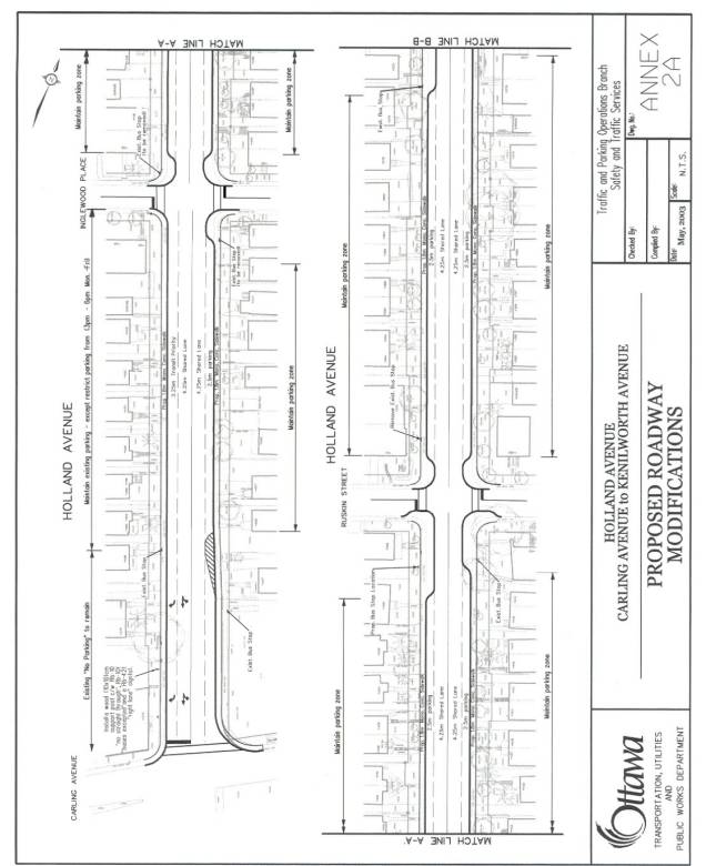
These benefits are achieved through special transit
signals, and through
a number of intersection narrowings, and through changes in the parking regulations
as shown conceptually on
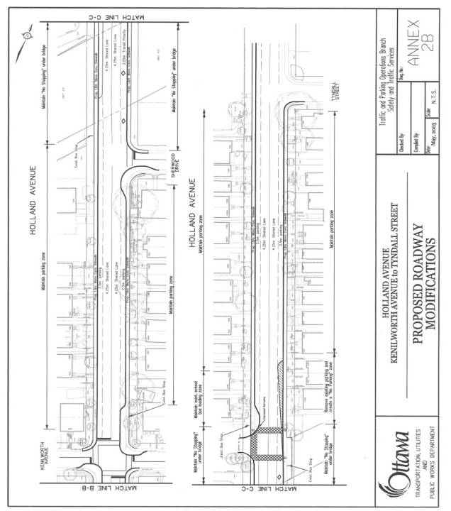
Annexes 2A and 2B. Intersection narrowings at Sherwood Drive, Kenilworth
Street, Ruskin Street, and Inglewood Place will: encourage motorists to drive
in an appropriate manner given the surrounding local environment; provide a
shortened pedestrian crossing distance; will prevent vehicles from passing on
the right; and, will provide bus stop locations following the principles of
transit priority.
Holland Avenue has a width that makes it
impossible to use current roadway design standards for all elements of the
roadway. A design that incorporated the best
balance of reduced widths was developed so that trees would not have to be
removed. The following table highlights the
desired width and the proposed width for each element:
Roadway Element |
Desired Width
|
Proposed Width
|
|
Sidewalk |
2.0m |
1.8m |
|
Parking
Lane |
2.8 |
2.5m |
|
Shared
Bicycle/Motor Vehicle Lane |
4.3 to 4.8m |
4.25m |
The constricted
width of Holland Avenue will require that sidewalks be built without
boulevards. They will be designed and built according to the City of Ottawa standardHarmonized Sidewalk
Technical Design Guideline (as approved by City Council on 22 May 2002) for
sidewalks built without boulevards. This will
which reduce the
“roller-coaster” effect by providing 2.4m transition slopes at driveways (i.e.
the sidewalk will slope gently down to the driveways), and providing
cross-falls that remain fairly constant along the length of the sidewalk (i.e.
varying between 2% and 2.8%).
The
transit priority measures planned for Holland Avenue will ensure that the
effects of vehicular congestion and signal delay on transit are minimized. This is important because every missed green
at major intersections is an approximate two-minute delay for all passengers on
board and all waiting passengers downstream plus the additional delay due to
missed transfers.
Most of the transit priority measures planned
for this section of the corridor will be implemented during this
reconstruction; however, a bus queue jump for northbound buses traveling along
Fisher Avenue/Holland Avenue at the approach to Carling Avenue will be
implemented as a separate project.
Without this queue jump, the Holland Avenue transit priority scheme is
not complete. The suggested transit priority
measures along Holland Avenue represent a relatively new approach to
implementing these measures because they will be done:
·
proactivelyProactively, before major interruptions to
transit service start to occur due to future traffic increase;
·
inIn conjunction with another municipal project
(sewer) to minimize costs and disruption; and,
·
inIn conjunction with other non-car related
improvements to achieve community objectives while contributing to the long termlong-term
transportation objective.
In
terms of vehicular level of service, defined as the volume to capacity (V/C)
ratio, there will not be any significant change because the V/C ratio of
critical intersections will not change.
ENVIRONMENTAL IMPLICATIONS
The modifications will improve the efficiency of
transit service on Holland AvenueThe Official Plan notes in Section 2.4 that maintaining the
environmental integrity of the City is critical. The support of walking, cycling and transit has a pivotal role in
reducing the city’s
energy consumption, improving air quality, and minimizing the overall demand for land and other resources.
The modifications proposed
for Holland Avenue will:
·
Improve the pedestrian environment by creating wider sidewalks
and by better buffering them from motor vehicles;
·
Improve the cycling facilities by
providing a shared
travel lane; and,
·
Improve the efficiency of transit service
on Holland Avenue
with transit priority measures..*****
RURAL IMPLICATIONS
N/A
CONSULTATION
The process that generated the 1997
Parkdale Area Transportation Study included extensive public participation
including a Steering Committee (which included members of the public), two
rounds of Focus Group meetings and three Public Open Houses.
More
recently, there was a meeting with about 20 community representatives from
three area community associations on 10 April 2003 where attendees reviewed and
made comments on the plan. There was
general support for the overall concept at this meeting. As well, approximately eighty people
attended a Public Open House on 8 May 2003, where the proposed modifications
were presented. Many members of the
public were in favour of the plan, however, some felt that the narrowings would
delay traffic at intersections when vehicles were turning onto and off of
Holland Avenue. Specific comments and
staff responses can be found in Annex 3:
Summary of Public Comments.
TRANSPORTATION MASTER PLAN
This project conforms with Section 2.4.3
– Transit Priority – of the 1997 Transportation Master Plan. The specific section of Holland Avenue
undergoing reconstruction is shown on the Transit Priority Network as detailed
in Transportation Master Plan - Map 2.
This is reconfirmed in the 2003 Draft Transportation Master Plan – Map
4.
Section 2.5.6 – Design Guidelines – of the 1997 Transportation Master Plan discusses the benefits of traffic calming (or similar) measures as possible solutions to operational or safety problems stemming from excessive automobile speeds or poor driver behaviour. The implementation of a series of intersection narrowings as a traffic management measure is a benefit in this regard. The 2003 Draft Transportation Master Plan reinforces the use of traffic management measures such as intersection narrowings to preserve neighbourhood liveability.
FINANCIAL IMPLICATIONS
Funding for the
Holland Avenue Integrated Road, Sewer and Watermain Reconstruction Project,
estimated at $2,680,000, is available in City of Ottawa Account 901285. Construction is scheduled to commence in
2003 and will be completed in 2004.
Funding to modify the traffic control signals to accommodate the transit
priority signals, estimated at $85,000, is available in City of Ottawa Account
902134 – Arterial Transit Priority.
Internal
Order #902134 – Arterial Transit Priority
Budget
Authority $1,980,000
Actual/Committed
to Date $ 108,804
Balance
Available $1,871,196
This
Request $ 85,000
Remaining $1,786,196
ATTACHMENTS
Annex 1 Key Plan
Annex 2A Proposed
Roadway Modifications – Carling Avenue to Kenilworth Avenue
Annex 2B Proposed
Roadway Modifications – Kenilworth Avenue to Tyndall Street
Annex 3 Summary of Public Comments
DISPOSITION
Subject to approval by Council of the recommendations
contained in this report, the reconstruction of Holland Avenue is planned to
begin in July 2003 and be completed by the end of 2004.
The parking bylaw will be modified through delegated authority to remove permitted parking in the afternoon peak period (3:00 p.m. to 6:00 p.m.)hour on the west
side of Holland Avenue between Inglewood Place and Carling Avenue.
Annex 1
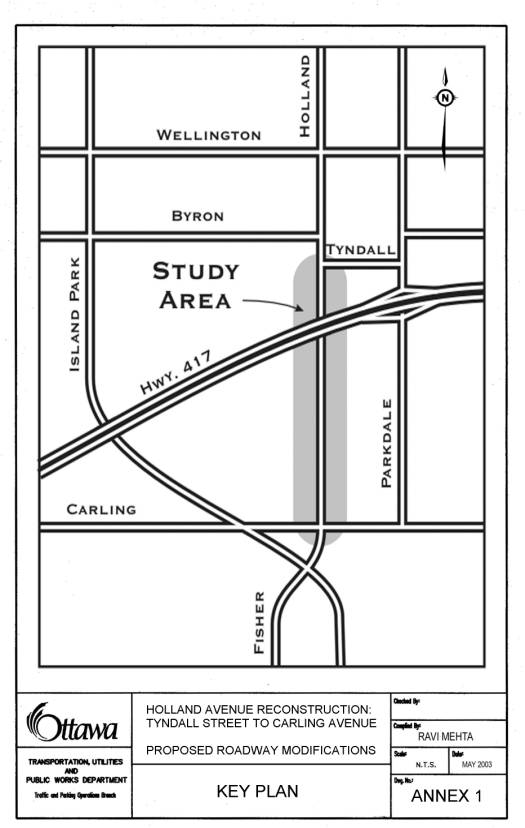 Key Plan
ANNEX 2A
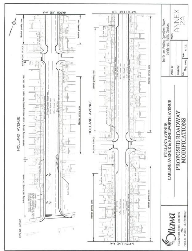 ROADWAY MODIFICATIONS - CARLING AVENUE TO KENILWORTH
AVENUE
ROADWAY MODIFICATIONS - CARLING AVENUE TO KENILWORTH
AVENUE
ANNEX 2B
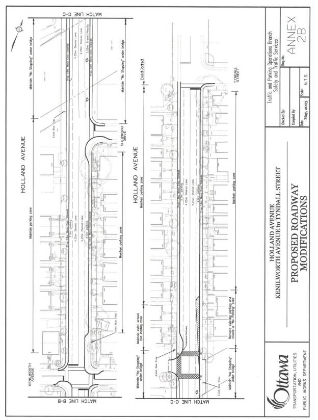
Roadway Modifications – Kenilworth Avenue to
Tyndall Street
Roadway
Modifications – Kenilworth Avenue to Tyndall Street
SUMMARY OF PUBLIC COMMENTS
The
City held a Public Open House on 8 May 2003 to present and discuss the proposed
changes to Holland Avenue. Of the
approximately eighty people that attended, thirty-seven completed comment
sheets. Many were in favour of the
plan, however, some felt that the narrowings would delay traffic at
intersections, when vehicles were turning onto and off of Holland Avenue. Specific comments and the action taken for
resolution, if
necessary, are:
·
Comments
in favour of the intersection narrowings (12 comments total):
o Narrowings will shorten distance for
pedestrians crossing
o They will create a physical barrier
to the “parking lane” being used as a driving lane especially in evenings when
only a few cars are parked on Holland Avenue. Currently drivers consider
Holland Avenue to be 4 lanes and therefore speeding cars are a problem.
o Traffic speeds will be reduced by
the narrowings.
·
Comments
in opposition to the intersection narrowings (13 comments total):
o Narrowings are hazardous for
cyclists that currently use “parking lane.” Staff Comment: Cyclists are provided for in the
shared cycle/vehicle lane.
o They create obstacles for snow
ploughs so residents expect big piles of snow in the winter blocking driveways.
Staff Comment: The narrowings are designed to facilitate winter ploughing.
o Signs placed on the narrowings
create hazard for cyclists and pedestrians and clutter the right-of-way.
Staff Comment: This signage will be installed according to standard practices
that account for cyclists and pedestrians. Regarding clutter, signage will be
kept to the minimum requirements to ensure roadway user safety.
o Nearside narrowings prevent vehicles
behind a left-turning vehicle from overtaking on inside, leading to idling
engines and frustrated drivers. Staff Comment: Near side narrowings are to
be implemented only at intersections where opposing through/left-turning
traffic volumes are sufficiently low as to not significantly reduce roadway
capacity.
o Buses stopping at the elongated
narrowings will slow traffic and lead to either frustrated drivers or hazardous
overtaking. Staff Comment: The principles of transit priority are to give
transit vehicles preferential treatment over other motorized vehicles..
The other alternative, requiring buses to stops in bus bays formed by parked
cars, is clearly a benefit to cars at the expense of transit.
o General slowing of traffic due to
buses and left turning vehicles will encourage some drivers to use adjacent
streets (especially north on Huron Avenue). Staff Comment: Due to the relatively short wait- time of buses at bus
stops (2-3 passengers per stop), there will be little incentive to divert to
other streets. There are 2 stops at
platforms in each direction and all have low passenger activity. The average delay for a vehicle that happens
to be behind a bus will be less than 30-45 seconds total for both stops.
o
They
contribute to increased greenhouse gas production due to inefficient use of
vehicles (idling engines, longer travel times). Staff Comment: As noted above, the average delay for a vehicle, that which happens to be
behind a bus, will
be less than 30-45 seconds total for both stops. The negative effects
of the delay to a few cars is outweighed by the positive benefits of
encouraging transit use. . In addition, the other alternative of, providing bus
stops in bus baysys,
would create delays of 5 to 15 seconds to each bus as they merge into traffic.
o
They
are perceived to be the same as measures on Parkdale Avenue and Kirkwood Avenue
that have not been well received and currently under review with a view to
remove. Staff Comment: A review of the measures on Parkdale Avenue and
Kirkwood Avenue has shown that the measures are effective.
o
The
travel lanes are too narrow at the intersection narrowings to allow for
cyclists to share the lanes comfortably with other vehicles. Staff Comment:
The intersection narrowings have been reduced from 2.5m in width to 2.25m thereby
allowing for an additional 0.25m on the shared bicycle/motor vehicle lane near
the narrowings.
·
Comments
on Transit Priority:
o
Allowing
buses to take priority is generally a good idea.
o Cyclists traveling south to Carling
Avenue will not know exactly where to position themselves relative to the curb.
Staff Comment: Cyclists will ride in the shared cycle/motor vehicle lane.
Visual queues for purpose of cues for bicycle
position within the roadway
will be taken from the intersection narrowings and/or if necessary, parked cars.
o
Southbound
cars wishing to turn right on Carling will want to use the transit priority
lane south of Inglewood. Staff Comment: It is intended that this lane
function as a right-turn-only lane for cars and as a through/right-turn lane for
transit vehicles.
·
Comments
on Widened Sidewalks:
o The wider sidewalks will be safer
for pedestrians
o The sidewalks do not need to be
widened, as there are so few pedestrians. Staff Comment: Improved sidewalks
will improve the walking environment for those who use the sidewalks, and may
encourage others to walk. They will be designed and built according to the
City’s Harmonized Sidewalk Technical Design Guideline as approved by City
Council on 22 May 2002.
·
Comments on Cconstruction:
o Can
we lift parking restrictions
on adjacent streets to offset the loss of parking on Holland Avenue? Staff
Comment: The potential temporary loss of parking will be reviewed when
developing the construction staging plan.
o Is there anything that can be done
to prevent adjacent streets (e.g. Harmer Avenue) being used during the
construction period? Staff Comment:
The potential diversion of traffic during construction will be reviewed when
developing the construction staging plan. Efforts will be made to ensure that
lanes on Holland Avenue remain open during construction.