![]()
Document 4
EAST-WEST
CORRIDOR
Light Rail
Transit (LRT) Project
(Orléans to
Kanata)
Environmental
Assessment
Terms of
Reference
![]()
April 2005
![]()
Document 4
EAST-WEST
CORRIDOR
Light Rail
Transit (LRT) Project
(Orléans to
Kanata)
Environmental
Assessment
Terms of
Reference
![]()
April 2005
TABLE OF CONTENTS
Page
1.1 Need/Purpose for Terms of Reference
1.2 Terms of Reference Consultation
1.3 Contents of the Terms of Reference
2.0 Project Description and study area
2.1 Purpose and Rationale of the Undertaking
3.0 GENERAL ENVIRONMENTAL ASSESSMENT
REQUIREMENTS
4.0 ENVIRONMENTAL aSSESSMENT Work Plan
4.1 Purpose/Problem - Opportunity Statement
4.2.1 Alternatives to the Undertaking
4.2.2 Alternative Methods of Carrying out the Undertaking
4.3 Existing Environmental Conditions
4.3.2 Detailed Description of the Existing Environment
4.4 Potential Environmental Effects
4.5.2 Evaluating Alternatives to the Undertaking.
4.5.3 Evaluating Alternative Methods of Carrying out the Undertaking
4.7 Implementation and Staging Plan
5.0 Environmental assessment
CONSULTATION PLAN
5.1 Coordination With Other Studies
6.1 Canadian Environmental Assessment Act (CEAA) Approvals
FIGURES
Figure 4‑1 Aerial Photograph
of Study Area (2002)
Appendix A – Acronyms and Glossary of Terms
Appendix B – Terms of Reference Consultation
Summary
Annex
1 - Consultation Group Meeting Notes (16 November 2004)
Annex 2 -
Notifications of Study Commencement and Terms of Reference Open Houses
Annex
3 - Open House Materials
Annex
4 - Transportation Committee - (16 February 2005)
Annex
5 - Consultation Group Meeting Notes (30 March 2005)
Appendix C – Excerpts from Statement of Work
Appendix D – Public and Agency Consultation
Groups
The City of Ottawa, the Proponent for the undertaking, proposes the preparation of an Individual Environmental Assessment (EA), in accordance with the Ontario Environmental Assessment Act (OEAA) for the East-West Corridor Rapid Transit Project. The proposed project would include expansion of the City’s rapid transit network to accommodate existing and future demand between the communities of Orléans and Kanata (and points in between) along an approximately 47 km east-west corridor generally following the existing Ottawa Central Railway and Cumberland Transitway corridors.
The intent of this expansion will be to support the modal split objectives of the City’s Transportation Master Plan (TMP) and existing and future developments in accordance with the City’s Official Plan (OP). It should be noted that this proposed project is one component of the City’s overall plan for transportation improvements required to support future growth. This initiative is in addition to other City work being undertaken on the North-South Corridor Light Rail Transit (LRT) Project and various road and land use planning studies. These other road and transit initiatives will be subject to separate Environmental Assessment studies.
This Terms of Reference (ToR) outline what will be studied in the EA to address the information requirements set out in Section 6.1(2) of the OEAA. The ToR have been prepared in accordance with Section 6(2)(a) of the OEAA. A listing of Acronyms and Glossary of Terms is included in Appendix A.
Through the EA study, the requirements of the Canadian Environmental Assessment Act (CEAA) will be identified and where possible, fulfilled. The Canadian Environmental Assessment Agency is involved in the proposed project including the development of this Terms of Reference, in order to facilitate a harmonized EA process.
Preparation of a ToR for Individual EAs became mandatory with the 1997 enactment of the Environmental Assessment and Consultation Improvement Act (1996), which amended the OEAA. Under the amended Act, an approved ToR and the subsequent EA completed in fulfillment of the ToR are necessary to satisfy the legislative requirements. The purpose of these ToR is to set out the requirements for the preparation of the environmental assessment (Section 6(2)(a)) for the East-West Corridor LRT Project.
In developing these ToR, the City of Ottawa has consulted with the general public, agencies and stakeholders. On November 30, and December 1 and 2, 2004, Public Open Houses were held in 3 locations across the City. Comments received during review of the draft ToR have been incorporated, where appropriate, within these ToR. The comments and meeting summaries are contained in Appendix B.
During the public consultation process opportunities for information exchange and feedback were provided through the City of Ottawa website, consultation group meetings and the Public Open Houses (Appendix B). Notifications occurred through advertisements in daily, citywide newspapers with regional coverage, as well as through the City’s web site.
The Terms of Reference were presented at the City of Ottawa's Transportation Committee on February 15, 2005. The Transportation Committee directed the Study Team to address the comments presented by the delegations.
Subsequently, the Study Team compiled all comments raised either by delegations at the Transportation Committee or sent to Transportation Committee Members and the Study Team. To ensure that all comments had been captured, the Study Team invited the public and agency consultation groups to identify any other outstanding concerns. Thereafter, responses to all comments were circulated to the public and agency consultation groups and the newly formed Business Consultation Group (BCG) in advance of a second series of consultation group meetings. Comments during the second reviewing of the draft ToR have been incorporated, where appropriate, within these ToR prior to being presented again to Transportation Committee on May 18, 2005.
Under Section 6 (1) of the OEAA, the project proponent must prepare and submit a ToR for approval by the Ministry of the Environment (MOE) prior to commencing an Individual EA study. Once approved by the MOE, the ToR provides the framework for preparing the EA and serves as a benchmark for reviewing the EA. It is the first statutory decision by the Minister in the EA planning and approval process.
The ToR sets out the minimum study requirements and describes the methodology for conducting the EA, including:
The ToR will be made available for public and agency review. Upon completion of the review period, the Minister of the Environment can either approve or reject the ToR. Once approval has been received, the proponent may proceed with the EA in accordance with the ToR.
This proposed project will likely require a review under the Canadian Environmental Assessment Act (CEAA). This ToR will not limit the scoping activity that the Federal Authorities will undertake once the CEAA is formally triggered.
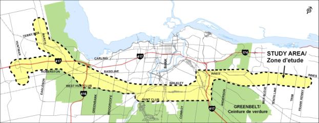
The proposed LRT Project is approximately 47 km long, spanning from Orléans to Kanata. The East-West LRT corridor would provide improved east-west transit connectivity bypassing the downtown. It also presents a unique opportunity to influence development within the growth areas of Kanata and Orléans as well as inside the Greenbelt.
The study area is a band along both sides of an existing rail corridor, which was defined in the Official Plan and Transportation Master Plan as the East-West LRT Corridor (Figure 2-1). In the east end, the band is narrower as the alignment has been defined by earlier studies (Cumberland Transitway Environmental Assessment Study, 1999). Along most of the alignment, the band is wide enough to consider potential parallel corridors such as arterial roads and hydro corridors. In Kanata, the study area widens out to consider several route options, which will be evaluated to determine which best serves the existing and future growth.
In May 2003, the City of Ottawa adopted a new Official Plan (OP) that projected a population increase from 800,000 to 1,200,000 people by 2021, a level of growth that will open new opportunities for the City and its residents. Transportation improvements are crucial in accommodating this population growth and the associated increases in travel demand.
The OP sets out a growth management strategy that emphasizes urban intensification and increased mixed-use development centred on rapid transit as a means to address travel demand and to discourage the use of single occupancy vehicles for peak period travel. This strategy supports the vision of sustaining the natural environment, optimizing economic vitality and ensuring healthy communities by minimizing the future need for new and widened roads, while avoiding levels of congestions and air pollution.
To further support this strategy, the City approved its new Transportation Master Plan (TMP) in September 2003. The TMP establishes objectives for transit use that would see the overall peak hour transit modal split increase from 17% to 30%, thereby requiring measures to make transit more competitive relative to automobile use. The TMP identifies an expanded rapid transit network as a key component to achieving this objective. This network was developed through the City’s Rapid Transit Expansion Study (RTES), carried out in 2002 and finalized in June 2003.
Overall, the recommended rapid transit network included three new Light Rapid Transit (LRT) lines and a number of extensions and additions to the existing Bus Rapid Transit (BRT) Transitway system. The network shows an east-west line extending from Orléans in the east to Kanata in the west, along with the expansion of the existing O-Train rail corridor north and east into the downtown and south and west to Riverside South and Barrhaven Town Centre. The North-South Line, and other transit initiatives identified as part of the TMP and RTES will be subject to separate Environmental Assessment studies. The purpose of the East-West Corridor LRT Project (the undertaking) is to:
The EA study will be consistent with the approach and requirements set out in Section 6.1 (2) of the OEAA. The EA will include the following components:
by the undertaking, the alternatives to the undertaking, and the alternative methods of carrying out the undertaking
The specific activities to be carried as part of the EA are described in more detail in Section 4.0 Environmental Assessment Work Plan.
The proposed schedule for the EA study (including legislated review periods) is as follows:
The following sections outline the activities planned to be undertaken to complete the environmental assessment.
The City’s RTES developed transit ridership projections as a basis for identifying, at a strategic level, an East-West transportation corridor. During the EA for the proposed project, a separate study will be conducted to provide greater confidence in east-west corridor ridership forecasts.
The East-West Corridor LRT Project also provides an opportunity by protecting for a key transportation facility, as early as possible. Within this context, the need for the undertaking is twofold:
Once the need/opportunity for the undertaking is confirmed,
the next step in the process will be to identify and evaluate alternatives to
address the need/opportunity.
Transportation planning alternatives represent functionally different ways of addressing a stated transportation problem and/or opportunity, as well as meeting the purpose of the undertaking. The OEAA requires that a Proponent provide a description of and a statement of rationale for alternatives to the undertaking. The alternatives to the undertaking will be subject to analysis and evaluation in the EA.
Alternatives to the undertaking that
have been identified for assessment in terms of their ability to address
existing and future problems and needs include, but are not limited to, the
following:
The assessment of transportation planning alternatives provides an opportunity to examine fundamentally different ways of addressing transportation problems. Much of the work undertaken to develop the City’s TMP and RTES will be used as a basis during the environmental assessment process. This work will be augmented with additional studies as appropriate.
If Do Nothing is selected as the preferred alternative, the EA process would be abandoned. A separate Municipal Class EA process would be followed if Expansion of Arterial Road Network is selected as the preferred alternative on its own or in combination with Rapid Transit Services.
If Rapid Transit is the preferred alternative to the undertaking, there are a range of improvement options that could be explored to implement the undertaking, including alternative technologies, alignments, stations and maintenance facilities. These alternatives will all be developed to maximize accessibility to all residents of the City in accordance with existing City policies.
Alternative
Technologies
To meet the requirements of the OEAA, all reasonable rapid transit technology options will be identified and evaluated for the Corridor. This work will not only define each technology, but will develop vehicle characteristics to be used in the later design stages. The technology information will be compiled in an objective manner to clearly identify the merits of the range of technologies that can meet the ridership needs and general constraints of the candidate technologies. The initial assessment and evaluation will include a comparison between bus and rail transit options. Should a rail option be selected, an evaluation of Diesel Multiple Units (DMUs), similar to the existing O-Train, electric LRT, and combinations will be examined depending on alignments being investigated. Combination options will be evaluated to take advantage of existing rolling stock, coordination with the North-South Line and compatibility with existing rail users of the Corridor.
Alignment
Alternatives
In developing alignments for the undertaking, consideration will be given to satisfying the need/opportunity as well as approved development plans and approvals already in place under previous environmental assessment. Hence, alignment alternatives will not be developed for the eastern section of the corridor from the Blackburn Hamlet Bypass to Frank Kenny Road, which is already approved as the Cumberland Transitway. Outside of the railway corridor identified in RTES, alternative alignments using arterial roads and hydro corridors for portions of the route will be examined. In the Kanata section, a of review alternative alignments to assess which corridor is most appropriate based on conditions such as existing and future land use, ridership and constructability will be undertaken.
Stations and Park and
Ride Lots
Station and Park and Ride lot alternatives will be developed in each corridor segment to take maximum advantage of land availability and ridership potential. Consideration will also be given to the ability to create transit-oriented developments around the transit facility and stations.
Other Supporting
Infrastructure
Alternative locations for storage and maintenance yards, including the existing Walkley Yard, will be examined. Based on the ultimate fleet requirements, yard layouts will be developed for each site in order to assist the City in the selection of permanent facility locations. Work in this area will be coordinated with the North-South LRT project.
Other infrastructure to support the project, including stormwater management facilities and potential electrical substations, will be located and evaluated as part of the overall alternatives assessment.
The study area boundaries include those areas within the identified Corridor footprint that may be affected by the proposed undertaking. The spatial boundaries may vary depending on the environmental features being investigated in order to address environmental affects and operational issues; to accommodate coordination with relevant on-going studies and projects; to identify transit stations and their locations as well as Park and Ride lot needs; and to identify future network connections.
The City of Ottawa is home to three watersheds – the South Nation Watershed to the east, the Rideau River Watershed dominating the central portion of the City, and the Mississippi River Watershed to the west. The Study Area includes all three watersheds. Connected to the river systems and watersheds of the City is a network of other natural features including forests, wetlands, meadows, parks, and other areas of open space. The most recognized feature of the green space network is the National Capital Commission (NCC) Greenbelt, as it encircles a significant portion of the City’s urban area. The proposed Corridor crosses the Greenbelt in two locations (Figure 4-1)
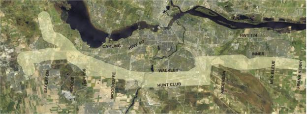
Figure 4‑1 Aerial Photograph
of Study Area (2002)
There is a wide range of land uses in the study area. Generally speaking, the eastern portion of the study area (Orléans) consists primarily of low and mixed density residential, developing communities, farms and market gardens and open space. Industrial, institutional, employment, commercial and mixed density residential areas dominate the eastern half of the central portion, with more mixed density residential in the western half of the central portion. Low to mid-density office/commercial development along with low and mixed density residential and developing communities are the primary uses in the western portion.
The central study area also encompasses the Walkley Yard rail facilities, which includes heavy industrial uses along its fringe. The rail facilities are still in use by Ottawa Central Railway, although the level of activity is significantly lower than historical levels.
Existing environmental conditions will be described to determine sensitivities and to provide a baseline against which to assess project effects and evaluate alternatives. Environmental, technical, and economic information will be collected and reviewed. The baseline research will identify the full range of conditions in the Study Area, which are likely to be affected by the undertaking. These features are generally outlined but not limited to the following.
Natural Environment: The study area includes several key natural features including watercourses (Rideau River, numerous creeks), Areas of Natural and Scientific Interest (ANSIs) and linkage corridors. All background information regarding waterways, floristics, significant trees, wildlife and other biological components that may be affected by the project will be collected. All vegetation communities in the study area and adjacent areas will be visited as required. Formal breeding bird and amphibian surveys will be completed in natural areas with data gaps. Locations of sensitive or significant species will be identified and habitat needs assessed. Written and photographic documentation will be provided, as appropriate.
Detailed information on soil, bedrock, contamination potential and hydrogeologic conditions will be compiled and reviewed. A summary of the soil, bedrock and hydrogeologic conditions within the study area will be prepared in the form of a set of plans containing a description of the general overburden soil conditions (type, thickness, location), the hydrogeology within the study corridor, and the known bedrock formations (formation type, typical bedrock properties, depth, thickness).
Economic Conditions: Economic/business conditions within the study area will be refined to include business activities by type and by major employers. A detailed inventory of proposed or planned development projects within the study area will be undertaken and, where available, forecasts of employment growth and distribution will be also be examined.
Social/Cultural Environment:
Valued components of the human environment that may be affected by the
project and therefore would require an assessment include: adjacent land uses;
planning context, including character areas; and Official Plan and zoning
provisions. A Stage 1 archaeological
investigation will be completed to determine if there are known archaeological
resources and/or the archaeological potential.
In addition, a comparative visual analysis of the cultural landscape
will be undertaken. Where appropriate,
existing noise, air quality and vibrations levels will be
determined/documented.
Technical/Transportation Conditions: Existing digital mapping, transportation studies, the City’s TMP schedules, engineering studies, structural assessments, land use, investigation reports and other available information related to and impacting on the study area will be obtained and reviewed. All existing services and utilities including stormwater will be reviewed and documented.
Transit ridership and existing route patterns will be reviewed. The existing traffic volumes and volume-to-capacity (v/c) rates for the relevant primary roads and major collector roads within the study area will be examined, as will historic traffic growth, based in part on screenline summaries.
Work
undertaken as part of the previous studies identified potential effects of the
undertaking. These are noted as “Major
Issues” in the excerpts from the Statement of Work (Appendix C).
The EA will describe and identify the environmental effects of the proposed undertaking and alternatives. Assessment of effects will be conducted at a more general and strategic level, based primarily on secondary sources of information when comparing alternatives to the undertaking and in more detail when comparing alternative methods for carrying out the undertaking. As alternative methods for the undertaking are developed, this general information will be supplemented with field data and additional research. When a preferred route is selected, further focused data will be collected. This process of collecting more detailed environmental data as the project becomes more defined will allow for available information at appropriate levels and will provide additional current information throughout the planning and functional design process.
Potential effects to be studied include beneficial and adverse effects that the proposed undertaking may have on the environmental feature. These will include, but will not be limited to, the following:
Natural Environment Effects:
Economic Environmental
Effects:
Social/Cultural Environmental Effects:
Technical/Transportation
Service Effects:
· Pedestrian, cycling, road and transit networks
· Transit ridership
· Safety and security
· Ability to meet or exceed the City’s modal split objective
· Intermodal connections to other transit routes and facilities
· Existing and future freight movements
· Utilities (above and below ground)
Assessment and evaluation of alternatives is a key component of the EA process. Assessment involves the identification of the magnitude of effects of alternatives based on a range of environmental factors or considerations. Once this step is completed, an evaluation is applied which may be defined as a “formal procedure for establishing an order of preference among alternatives” (MOE, 1990). There are a number of methods available. Due to the nature of this environmental assessment, various methods may be employed.
The preliminary evaluation of alternative solutions will be conducted at a general level when comparing alternatives based primarily on secondary source information and work undertaken to date on previous studies. A comparative checklist of similar descriptive evaluation method will be applied.
A methodology, which considers the use of criteria, weighting/ranking and sensitivity analysis may be more appropriate for the evaluation of alternatives to the undertaking and route. In selecting an appropriate evaluation method for the study, consideration will be given to a method, which would reflect:
· Sound planning principles;
· Project complexity;
· Varied community interests; and
· A rigorous traceable and defensible process.
Ultimately, the selection of a preferred solution/design will involve impact analysis and evaluation, and consultation with the consultation groups and the general public. Criteria will be identified along with the rationale for inclusion and the indicator(s) used to qualify/quantify it. Criteria will be developed from all key components of the existing environment.
Consideration will be given to a variety of evaluation methods including computer software programs, Multi-Attribute Trade-off System (MATS), pre-screening and more rigorous methods such as Concordance. Depending on the final evaluation method selected, Sensitivity Analyses may be applied.
Comments received from the public, consultation groups and other stakeholders will be used to prepare and confirm the detailed criteria to identify the potential effects of the alternatives and undertake the evaluation.
Criteria that may be used to evaluate
alternatives may include, but not be limited to:
· Effect on transportation system performance and convenience (e.g. demand/capacity analyses);
· Transit System integration – intermodal connectivity;
· Consistency with City of Ottawa policies and objectives;
· Effect on socio-economic environment;
· Effect on urban form;
· Effect on natural environment; and
· Costs.
At this stage, evaluation of alternatives with respect to these criteria will be largely undertaken on a qualitative basis, drawing on the results of the inventory of the existing environment and incorporating quantitative information where appropriate. Work from previous studies will also be used where appropriate.
Alternative methods of carrying out the undertaking will be evaluated using factors that may include, but not be limited to:
Natural Environment
·
Habitat
and population effects
· Contamination considerations
· Climatic effects
· Water quality and quantity effects
Social/Cultural
Environment
· Socio-economic effects
· Noise, Air Quality and Vibration
· Cultural and heritage effects
· Effects on transit ridership
· Effects on land use objectives
· Effects on the image of the Nation’s Capital
· Regulatory constraints
Economic
Environment
· Property requirements
· Fleet size and composition
· Operating and capital costs
· Lifecycle costs
Technical
Considerations
· Travel time/Speed
· Reliability
· Frequency
· Energy supply
· Integration with the transit network (existing and planned)
· Operating constraints
Initial options for locations and design of the new infrastructure and facilities such as stations, Park and Ride lots, maintenance facilities and other supporting infrastructure will be developed. These options will be prepared at the level of detail sufficient for identification and evaluation of the full range of environmental effects of each alternative alignment and station locations if required. The evaluation will consider mitigation measures and the resulting net effects on the environment.
Comments from the public, agencies and stakeholders will be incorporated in the analysis of the alternatives, resulting in the refinement of the analysis as required.
The potential effects of each alternative alignment on the environment will be compared in a traceable and objective manner and used to identify the preferred alternative. An evaluation methodology that allows for the comparison of quantitative and qualitative data will be selected. The methodology and analysis results will be presented to the public for comment and will be subsequently documented in the EA Report.
Potential environmental effects will be identified for the undertaking and its alternatives by relying on the relevant criteria, data sources and studies. The identification of potential impacts will consider the effects on the existing environment. An environmental effect can be described as any change that a project may cause in the environment. The effects analysis will involve applying the following steps:
Step 1. Identify and analyze instances where the project may interact with existing environmental conditions.
Step 2. Develop mitigation measures.
Step 3. Identify residual environmental effects, if any.
Step 4. Determine significance of the residual environmental effects, after mitigation.
Step 5. Identify and assess potential cumulative environmental effects
Following public and agency review of the alternatives to the undertaking, and the evaluation of the alternatives, the locations and conceptual designs of the preferred alternative will be refined and finalized.
Specifically the preferred alternative will be developed to a level of detail so that the potential effects on the environment are known and mitigation measures developed and documented as part of the EA study. In addition, a staging and implementation plan will be developed.
The undertaking will be developed in sufficient detail to identify the following:
· Horizontal and vertical alignment (ensuring accessibility and safety operation)
· Cross sections
· Structures
· Property requirements
· Access to adjacent properties
· Impacts on cycling and pedestrian facilities
· Potential streetscaping and other urban design improvements
· Station details
· Retaining walls
· Watercourse crossing details
· Drainage and stormwater management
· Illumination
· Impact on vehicular traffic
· Integration with existing bus routes
· Utility impacts and relocations
· Preliminary capital and operating costs
Mitigation can be defined as actions and design features incorporated in the pre-construction, construction, and operation phases that have the specific objective of lessening the significance or severity of negative environmental effects which may be caused by the project. The East-West Corridor LRT Project will be designed and be implemented with the benefit of contemporary planning, engineering, and environmental management practices for construction. Regard shall be had for the legislation, policies, regulations, guidelines, and best practices of the day. Where appropriate, mitigation measures will be prescribed in the future construction contracts and specifications. As this process will be iterative as alternatives are developed and evaluated, opportunities to avoid or minimize impacts will be integrated wherever feasible.
Appropriate technical and economically feasible mitigation measures will be developed for specific characteristics and sensitivities of the environmental features and the related significance of the potential impact. Such measures may include, but will not be limited to:
Mitigation measures will be developed in consultation with appropriate agency staff and stakeholders to confirm the environmental analyses, issues and impacts, and subsequently to review the impact assessment and mitigation measures. Mitigation measures will also include recommendations for a monitoring program.
Due
to the potential long-term nature of this undertaking, the EA will include a Staging Plan that will include recommendations
as to which section should proceed first, and why. The Plan will consider a strategy that maximizes transit
ridership, that is cost effective, and that minimizes disruption to existing
transit service as well as to roadway, pedestrian, bicycle, or railway
traffic. The Plan will include
recommendations for traffic management, municipal servicing and ongoing agency
and public consultation requirements.
Minimizing throw-a-way costs will also be a key consideration.
The City of Ottawa is committed to the preparation of a compliance monitoring strategy and schedule during the preparation of the EA study, to measure impacts such as noise, water quality and air quality effects associated with the construction and operation of the undertaking.
The monitoring strategy will be developed in consultation with the Environmental Assessment and Approvals Branch of the MOE. The proponent must comply with the terms and conditions as well as the commitments identified in the EA and report to MOE on how the compliance has been achieved.
The framework for the monitoring strategy may include, but not be limited to, the following elements:
· Compliance monitoring and effects monitoring;
· A plan for implementation of mitigation and contingency measures;
· Post construction monitoring and contingency measures and agreed upon triggers for employing contingency plans;
· Provisions for monitoring water quality and quantity, air quality, and soils;
· Provisions to assess compliance with EA commitments and environmental standards for both construction and operation; and
· Details on monitoring and reporting relationships.
The EA will describe how the proponent will achieve compliance (e.g. technical agencies approval and satisfy public interest) and how the compliance will be reported. The proponent or its contractor will be required to obtain all permits from regulatory agencies (e.g. MOE, Conservation Authorities, Transport Canada, MNR, DFO) prior to construction and will ensure compliance with all permit conditions throughout the work.
An amending procedure will also be developed to address changes to the preferred alternative that may occur following the completion of the EA and approval and its implementation. The amending procedure will:
· Define minor changes and major changes;
· Outline how the proposed changes will be examined;
· Detail the stakeholder consultation to be undertaken when considering the changes;
To provide a clear, understandable and traceable planning process, the information gathered in preparation for and during the study will be documented as follows:
1) Various working and technical papers will document the inventory and analysis of existing and planned future conditions (including identification of data sources, methodology, and their limitations) and the public/agency input into it.
2) An Environmental Assessment Report (EA Report) will document the following:
· Executive Summary (including list of technical reports and a map showing the location of the preferred undertaking);
· Purpose and Rationale for the Undertaking;
· Description of the Environment that will be Affected;
· Evaluation of Alternatives to the Undertaking;
· Evaluation of Alternative Methods of Carrying out the Undertaking;
· Description of the Preferred Alternative (including plans and profiles);
· Assessment of the Effects that will be caused or that might reasonably be expected to be caused to the environment;
· Implementation and Staging Plan;
· The proposed Mitigation Measures;
· Amending Procedure;
· The Consultation Undertaken; and,
· Commitments to future action, including external approvals known to be required.
The EA Report will be submitted to the Minster of the Environment for a decision on approval. The Minister of the Environment will then initiate a formal public and government review of the EA Report to assist in making a decision on whether to approve the undertaking.
Reference copies of the EA Report will be made available at local libraries and universities, Ottawa City Hall, City Client Service Centres and the MOE Regional and/or District office.
There is significant public interest
in this study from a variety of stakeholders.
Accordingly, consultation must be inclusive and appropriate for a study
of this type and will be dependent, in part, on broad and effective
consultation, communication and consensus building. The sharing of information in an open manner
and the involvement of the public, stakeholders and agencies as early as
possible will promote a sense of confidence that there is adequate opportunity
to input into the process and that concerns are being addressed in a responsive
manner. The main features of the consultation plan
follow.
Given the need for an enhanced public consultation process, the study team will adhere to the City’s Official Plan’s Guiding Principles by conducting an open and participatory process, building partnerships and creating public awareness.
Consultation Groups: There will be three invited Consultation Groups involving community and focussed interest groups, and government agencies. These Groups will meet in advance of each round of Public Open Houses. The roles of these groups will be to provide input, opinions and interactive dialogue with the Study Team. They will assist the City in advancing the study, but will not be the sole source for public and other stakeholder input.
Public Consultation Group (PCG): A PCG has been formed to enable community and special interest groups to provide direct input to the study and comments on local issues and concerns. PCG members are listed in Appendix D and include representatives from City wards, Focussed Interest Groups and various City of Ottawa advisory committees.
Agency Consultation Group (ACG:) An ACG has been formed to address the full range of technical issues and to comment on special studies as well as applicable procedures, legislation and policies. ACG members include agencies and government department representatives from Municipal, Provincial and Federal levels (Appendix D). Additional agency consultation (i.e., utility companies) will be undertaken as required.
Business Consultation Group (BCG): A BCG has been formed to review work-to-date and to provide comments on study activities, issues and concerns that reflect each group’s interests and values. BCG members are included in Appendix D and include City-wide Chambers of Commerce, business associations, institutions and large commercial establishments.
Individual meetings may also be required with various stakeholders to discuss specific issues as the study progresses.
Public
Open Houses: Will be held at key stages to obtain input and feedback
from the general public. The Open Houses will be organized to
allow informal viewing of display panels about the project and the examination
of resource material related to the various stages of the EA. Members of the Study Team will be present to
answer questions. Panels will be
presented in a series of stations focussing on a particular theme to facilitate
understanding of the project. All
displays and maps will be bilingual.
During the course of the EA, three sets of Public Open Houses will be convened at 3 separate locations to present information and obtain input and feedback. The meetings are tentatively scheduled for September 2005, February 2006 and June 2006. Explanatory panels will be set up in a walk through and ‘drop-in’ style format with staff on hand to respond to any questions and discuss the study on a one on one basis. Handouts will also be provided in both official languages.
Notifications
of Open Houses will be through advertisement in daily, citywide newspapers with
regional coverage as well as through the City’s web site. Prior to each Open House, a Public Service
Announcement will be issued and distributed to all daily and community
newspapers in Ottawa.
In advance of the Public Open Houses, meetings will also be scheduled with the consultation groups.
EA
Open House #1
The purpose
of this Open House will be to provide information on: the project need,
existing environmental conditions, alternative solutions, and evaluation and
the identification of the preliminary preferred solution. Technology
alternatives and characteristics will also be presented. Comments and input from the public will be solicited.
EA
Open House #2
This meeting
will present the alternative designs; the detailed existing condition
information, the evaluation criteria and methodology, and the preferred
alternative design. Comments and input
from the public will be solicited.
EA Open House
#3
The objectives of this Open House will be to present
the preferred design; its staging, the cost, the assessment of effects; the
proposed mitigation measures; and to solicit comments and input from the
public.
Comments and discussions during these meetings will be documented and used to refine the final study plan for City of Ottawa Transportation Committee and Council approval followed by the subsequent submission of the Environmental Assessment Report to MOE.
Web Site: The
information prepared for the Open Houses will also be formatted in a manner for
incorporation into the City web site with consideration for accessibility issues
related to graphics and other printed materials. In addition, ongoing project information, the Frequently Asked
Questions (FAQ) and other related materials will be posted on the site.
The EA Study process will also take into consideration information including analysis and preliminary findings of concurrent transportation and infrastructure projects that could influence the direction and/or conclusions of this Study. Some of these projects include but are not limited to:
· Innes-Walkley Connection EA
· Environmental Assessment Study for the North-South LRT
· Kanata West Development Area Transportation Network EA
· Relevant Community Design Plans
Additional approval requirements may be outstanding at the time of seeking approval under the OEAA. A number of subsequent approvals may require detail design and process information that is not available at the time of OEAA approval. The City of Ottawa is committed to obtaining the necessary approvals at the appropriate time in the implementation phase.
The agencies responsible for issuing approvals will be consulted during the EA to address their interests and approval requirements. This will minimize potential complications at the time of approval, thus providing reasonable assurance that the approvals will be obtainable. The following approvals may be required:
· Official Plan amendment and zoning bylaw changes if needed
· National Capital Commission approvals
· Water taking permit from MOE
· Sewage and water approvals, under the Ontario Water Resources Act for stations and maintenance facilities
· Municipal Noise bylaw amendments/exemptions if required during construction
· Municipal building permits
· Utility Approvals (Bell, Hydro, etc.)
· Environmental Protection Act approvals for wastes generated at stations and maintenance facilities
· Railway Approvals
· Fisheries Act Authorization
· Navigable Waterways Protection Act Permit
· Migratory Bird Act permits
The requirements of CEAA may be triggered for this project if there is:
· Federal lands required;
· Federal funding provided; or
· Federal agency approvals required that are listed on the Law List Regulations (e.g., Fisheries Act Authorizations, Navigable Waters Protection Act Permits, permits issued by the Canadian Transportation Agency, Parks Canada license/agreement).
Many of the requirements of CEAA are similar to the requirements of the Ontario Environmental Assessment Act. The key distinguishing features under CEAA are the requirements for:
· An analysis of effects of accidents and malfunction;
· All environmental effects that may result from the abandonment and decommissioning of a project if it is determined that those undertakings are a foreseeable and planned part of the proposed undertaking;
· A determination of the need for and requirements of a follow-up program;
· An analysis of the likelihood of significant adverse environmental effects; and
· A cumulative effects assessment.
As part of this EA, the City will endeavour to coordinate Federal and Provincial EA requirements. The overall objective is to integrate the technical and consultation requirements of both Acts to minimize duplication. Through early and ongoing involvement of Federal agencies, beginning with the initial project phases, the objectives of coordination can be more easily obtained.
The provision of a project description with sufficient detail to allow federal authorities to determine whether CEAA is likely to be triggered or if they have expert advice to offer is a crucial step in obtaining input and direction from the federal authorities. This will be accomplished as early in the process as possible by consultation with the Canadian Environmental Assessment agency, in its anticipated role as federal environmental assessment coordinator. Federal authorities will be invited to participate according to their policies of “in until out”. That is, federal authorities that may be triggered will participate in the assessment process in advance of a formal trigger.