2. Ontario Municipal Board Appeal - ZONING/subdivision
- 6851 Flewellyn Road Commission des affaires municipales de l'Ontario
appel - ZONAGE/plan de lotissement - 6851 chemin Flewellyn
|
Committee RECOMMENDATIONS
That Council endorse the following position at
the Ontario Municipal Board hearing for 6851 Flewellyn Road:
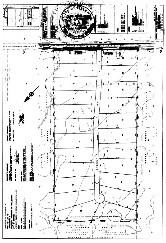
1. that the draft plan of Subdivision as shown in Document 1 be
refused;
2. that the Zoning By-law Amendment to rezone 6851 Flewellyn
Road from Rural Zone (RU) to Estate Residential (ER) be refused; and
3. that appropriate staff
resources, from the Corporate Services and Planning and Growth Management
Departments be committed for participation in the Ontario Municipal Board
hearing.
RECOMMANDATIONS DU COMITé
Que le Conseil appuye la position suivante à l’audience de la Commission
des affaires municipales de l’Ontario concernant le 6851, chemin
Flewellyn :
1.
Que le plan de lotissement provisoire, tel
qu’il est indiqué dans le document 1, soit refusé;
2.
Que la modification au Règlement de zonage
en vue de changer le zonage du 6851, Flewellyn de zone rurale (RU) à zone
résidentielle de grand ensemble (ER) soit refusée;
3. que les ressources en
personnel appropriées des Services généraux et du Service de l’urbanisme et de
la gestion de la croissance soient engagées à participer à l’audience de la
Commission des affaires municipales de l’Ontario.
Documentation
1.
Deputy City Manager, Planning and Growth Management report dated
9 May 2005 (ACS2005-PGM-APR-0140).
2. Extract of Draft Minutes, 12 July 2005.
Report to/Rapport au :
Planning and Environment Committee
Comité de l'urbanisme et de
l'environnement
and Council / et au Conseil
Submitted by/Soumis par : Ned
Lathrop, Deputy City Manager / Directeur municipal adjoint
Planning and Growth Management / Urbanisme et Gestion de la croissance
Contact Person/Personne ressource : Grant
Lindsay, Manager / Gestionnaire
Development Approvals / Approbation des
demandes d'aménagement
(613) 580-2424 x13242,
Grant.Lindsay@ottawa.ca
REPORT RECOMMENDATIONS
That the Planning and Development Committee recommend
that Council endorse the following position at the Ontario Municipal Board
hearing for 6851 Flewellyn Road:
1. that the draft plan of Subdivision as
shown in Document 1 be refused;
2. that the Zoning By-law Amendment to
rezone 6851 Flewellyn Road from Rural Zone (RU) to Estate Residential (ER) be
refused; and
3. that appropriate staff resources, from the Corporate Services and Planning and Growth Management Departments be committed for participation in the Ontario Municipal Board hearing.
RECOMMANDATIONS DU RAPPORT
Que le Comité de l’urbanisme
et de l’environnement recommande au Conseil d’appuyer la position suivante à
l’audience de la Commission des affaires municipales de l’Ontario concernant le
6851, chemin Flewellyn :
1.
Que le plan de lotissement provisoire, tel
qu’il est indiqué dans le document 1, soit refusé;
2.
Que la modification au Règlement de zonage
en vue de changer le zonage du 6851, Flewellyn de zone rurale (RU) à zone
résidentielle de grand ensemble (ER) soit refusée;
3.
que les ressources en personnel appropriées
des Services généraux et du Service de l’urbanisme et de la gestion de la
croissance soient engagées à participer à l’audience de la Commission des
affaires municipales de l’Ontario.
BACKGROUND
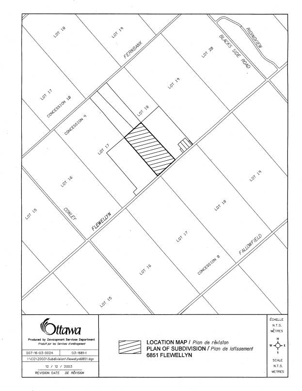
The subject property is located on the north side of
Flewellyn Road approximately 2.5 km west of Huntley Road in a rural area west
of Stittsville. The topography is
relatively flat with surface water running off to the southeast into the Flow
Creek (a tributary of the Jock River).
To the north of the subject property are a number of wetland areas that
form part of the Goulbourn Wetland Complex, a Provincially Significant
Wetland. This wetland acts as a
headwater to both Poole Creek and Flowing Creek drainage systems.
In the early 1990s the Ministry of Natural
Resources (MNR) conducted and/or approved evaluations of wetlands in the
Goulbourn Wetland area and classified wetlands according to the Ontario Wetland
Evaluation System criteria. Those wetland
areas, that were deemed to be Provincially Significant, were designated in the
upper and lower tier municipalities Official Plans. As recently as 2003, additional studies and wetland evaluations
have taken place that have resulted in the MNR complexing new wetland areas as
well as existing evaluated wetlands to the Goulbourn Wetland Complex.
The subject property is identified as
Environmental Feature on Schedule K of the Regional Official Plan as it forms
part of the Stittsville West Natural Area.
As such, an Environmental Impact Statement (EIS) is required to
demonstrate no negative impact on the natural features and functions of the
natural area. The EIS prepared to
support the rezoning and subdivision applications identified wetland habitat on
the property. The City's natural environment
database had this area classified as "forest dry" not wetlands. City staff reviewed existing natural
environment information for the area with representatives from the Ministry of
Natural Resources and Rideau Valley Conservation Authority. It was determined that there could be
several unidentified and unevaluated wetlands in the surrounding area including
this property. Further, given the
proximity of a Provincially Significant Wetland, the Goulbourn Wetland Complex,
the significance of these unevaluated wetland areas needed to be determined
prior to processing the development application.
As the evaluation of the wetland involved
multiple prosperities and landowners, the Department in cooperation with MNR
and the RVCA initiated the study to identify and evaluate wetlands within the
vicinity of the Goulbourn Wetland Complex.
The applicant was informed of the requirement to evaluate the wetland on
and adjacent to the subject property and that the City could undertake this
work. Initially, the applicant was
willing to cooperate, however, later withdrew his support and requested that
the Subdivision and Zoning By-law applications be considered by the Planning
and Environment Committee.
These applications were brought forward to
Planning and Environment Committee on September 28, 2004. At that time, the wetland evaluation
commissioned by the Department had not been completed. Staff recommended that both the rezoning and
subdivision be denied as issues concerning the unevaluated wetland, drainage concerns
and soil study were not adequately addressed.
The Committee referred these application back to staff for further
study.
In January 2005, the evaluation was completed
on the potential to complex unevaluated wetland areas in the vicinity of the Goulbourn
Wetland Complex. The findings of this
analysis has identified 20 new wetland areas that meet the criteria to be
complexed with the Goulbourn Wetland Complex.
The subject property forms part of one of the newly identified wetland
areas. The results were reviewed and
accepted by MNR. As a result of the
complexing, wetlands on this property are now considered to be part of the
Goulbourn Wetland Complex and, as such, are considered to be Provincially
Significant.
The applicant has requested that the City
process the applications without any consideration of the land being
Provincially Significant Wetland given that at the time the applications were
made the property was and still is designated General Rural Area. Staff support MNR's determination that the
entire property is Provincially Significant Wetland.
Apart from wetland issue, staff requested supplementary geotechnical and stormwater information in January 2004 to determine if the site was suitable for development. This information has not been provided as the applicant has waited for the outcome of the wetland evaluation. The applicant has appealed the applications to the Ontario Municipal Board under the provision that a decision was not reach within the 90 days.
DISCUSSION
The development applications were submitted
prior to the approval of the new Official Plan. As such, the applications are processed under the policies of the
former Region and Township of Goulbourn Official Plans. The property is designated as General Rural
Area on Schedule A of the Regional Official Plan and Environmental Feature on
Schedule K. Section 5.4.3.2 of the
Regional Official Plan requires an Environmental Impact Statement be submitted
in support of the subdivision application.
An EIS was prepared for the applicant and it identified thicket swamp
and swamp forest vegetation communities covering most of the property. A small dry-fresh white cedar-popular mixed
forest at the northern end of the property.
The former Township of Goulbourn Official Plan identifies the property
as Marginal Resource and permits Country Lot development in these areas subject
to the criteria outlined in Section 7.2.3.
One of the primary criteria for Environmental/Ecological Considerations
is that country lot development shall not be located on lands having organic
soils whether or not such lands are identified on Schedule ‘B’. This is balanced by Section 10.6 stating
that Council may approve development in areas with organic soils if the
proponent provides sufficient soils and engineering information to indicate
that the land is suitable or can be made suitable for the proposed development
without causing adverse environmental effects.
The terrain analysis, submitted with the application, indicated that most
of the property is covered with one to two metres of peat (organic soil). The presents of the organic soils prompted
staff to request a Geotechnical Report as required in Section 10.6. The Environmental Impact Statement that was
submitted does not identify that there are organic soils on the site and is
silent on what effects the development will have on the wetland
communities. The removal of the peat
and dewatering will have a significant impact on the environmental function of
the site.
Staff are also concerned that the drainage area identified in the
proponent's Conceptual Stormwater Management Plans does not correspond with the
City’s information for this area. There
is concern that there is more water traveling through this site than previously
determined. The flat topography present a challenge in providing sufficient
grading for road side ditches. Staff has requested that a Revised Conceptual
Storm Water Management Plan be submitted addressing these issues. This plan and the Geotechnical report have
not been submitted by the applicant.
They wish to resolve the wetland issue which will determine the extent
of (if any) development.
The recent wetland evaluation conducted has identified this property as
part of a larger wetland that has been complexed with the Goulbourn Wetland
Complex. As a result of these findings
and their acceptance by MNR, the entire property is considered Provincially
Significant Wetland. Staff must rely on
the most recent information, prior to the approval of an application for
subdivision development. The applicant
contends that the City should recognize the applicable policies that were in
place at the time of the filing of the application, which do allow for the
consideration of the subdivision The
Department concurs with MNR's position that the subject property is significant
wetland and that the policies relating to Provincially Significant Wetland
should be followed.
The Natural Heritage policies of the Provincial Policy Statement (PPS)
and the Regional and Goulbourn Official Plans seek to protect those wetlands
which are of sufficient size and biological diversity to be considered of
environmental significance. It is
within the mandate of the Ministry of Natural Resources to identify, evaluate
and delineate wetlands. Wetland
protection is achieved in two ways; 1) by prohibiting development within their
boundaries and 2) by carefully designing adjacent development to minimize the
impact on the wetland. Appropriate
design is to be based on the results of a Wetland Impact Study.
More specifically, the Natural Heritage policies of the Provincial
Policy Statement state that “Development and site alteration will not be
permitted in significant wetlands south and east of the Canadian Shield” and
that “development and site alteration may be permitted on adjacent lands…if it
has been demonstrated that there will be no negative impacts on the natural
features or on the ecological functions for which that area is identified.”
The Natural Environment Policies of the Regional Official Plan are
similar in that Council shall “not permit development and site alteration
within Significant Wetlands south and east of the Canadian Shield”. The policies also indicate that when
determining the extent and significance of wetlands, Council shall “seek the
advise of the Ministry of Natural Resources”.
Furthermore, development or site alteration “adjacent to wetlands
requires a Wetland Impact Study (WIS) or its equivalent". This study must demonstrate that
…construction requiring approval under the Planning Act, or site alteration
will not negatively affect the wetland.”
The Department is recommending refusal of both the Zoning By-law amendment and Plan of Subdivision on the grounds that the City is not satisfied that the development proposal conforms to the applicable Provincial Policies and Regional or Goulbourn Official Plan policies for the protection of wetlands. The Department is also recommending approval of City staff's participation at the upcoming Ontario Municipal Board Hearing.
ENVIRONMENTAL IMPLICATIONS
The subject property is identified as Environmental
Feature on Schedule ‘K’ of the Regional Official Plan. The applicant provided an Environment Impact
Statement, as required by the Official Plan, to support the application, which
describes the subject property as part of the Stittsville West Natural
Area.
Environmental Features policy of the Regional
Official Plan states that Council shall protect significant environmental
features and functions found within natural complexes such as rare species,
significant wildlife, areas that support hydrological functions. The forest on the property is primarily
young to intermediate in age but is predominately wet - swamp forest. The Environment Impact Statement states that
the site is one kilometer from the nearest Provincially Significant
Wetlands. However, the thicket swamp
and swamp forest found on the subject property extends over onto the abutting
properties to within 100 metres of the Goulbourn Wetland Complex. This proximity to an already evaluated
Provincially Significant Wetland and the hydrological connection and functions
between them met the complexing criteria in the Ontario Wetland Evaluation
System to connect the new wetland areas with the Provincially Significant
Goulbourn Wetland Complex. The Ministry
of Natural Resources is in agreement with the findings and recommendations of
the current wetland report and now considers the wetland on the subject property
to be Provincially Significant Wetlands.
With the determination that the wetland on the subject property is Provincially Significant, the City cannot support development of the site consistent with the Provincial Policy Statement as well as significant wetland policies in the Regional and Township of Goulbourn Official Plans.
Staff cannot recommend that the By-law
amendment or the draft plan of subdivision be supported. The 2005 report on "Potential to
Complex Un-evaluated Wetland Areas with the North Goulbourn Wetland
Complex" has concluded that most of this property is covered by
Provincially Significant Wetlands. The
Official Plans and the Provincial Policy Statement clearly prohibit development
of estate lot subdivision within their boundaries.
The City is still waiting on supplementary
information concerning the drainage and soils on the property. Staff requested a Revised Conceptual
Stormwater Management Plan and a Geotechnical Study in January 2004.
These reports are to address the policies
concerning development within Rural Natural Feature and areas with organic
soils, which requires that the development have no negative impacts on the
features and their environmental function.
This will be difficult to address as large amounts of peat will be replace
by fill and that improved drainage will dewater the site and surrounding
wetland.
CONSULTATION
Notice of this application was carried out in accordance with the City’s Public Notification and Consultation Policy. Information signs were posted on-site indicating the nature of the application. The Ward Councillor is aware of this application and the staff recommendation.
This site had raised a number of concerns among the environmental community in Goulbourn prior to an application being made. Due to the thick organic soils, a road bed was constructed on the property to conduct the hydrogeological study. The group contacted the Ward Councillor and staff where consulted. The same individuals contacted MNR and highlighted that the property contained unevaluated wetlands and that it should be evaluated. The wetland evaluation prepared in 2005 has been provided to a member of this group.
RURAL
IMPLICATIONS
The proposed development will impact the rural natural features that are present on the property. The applicant has not provided sufficient evidence through a Revised Conceptual Storm Water Management Plan and Geotechnical Report that this site is suitable for development.
FINANCIAL IMPLICATIONS
APPLICATION PROCESS TIMELINE STATUS
The application was not processed within the
timeframe established for the processing of Zoning By-Law amendments due to the
complexity of the issues associated with the unevaluated wetlands and engineering
concerns.
SUPPORTING DOCUMENTATION
Document 1 - Location
Map
Document 2 - Draft Plan of
Subdivision
DISPOSITION
Department of Corporate Services, Secretariat
Services to notify the owner Flewellyn Land Holdings Inc., Mario Staltari, 4
Eagle Lane, Ottawa, K2E 1B5, applicant Ray Essiambre, 14 Abbotsford Road,
Kanata, K2L 1C3, lawyer Janet Bradley, Gowlings, 2600-160 Elgin Street, Ottawa,
K1P 1C3, lawyer Soloway Wright, Douglas Kelly, 900-427 Laurier Avenue, Ottawa,
K1R 7Y2, All Signs, 8692 Russell Road, Navan, ON K4B 1J1, and the Program Manager, Assessment, Department of
Corporate Services of City Council’s decision.
LOCATION MAP Document
1
DRAFT PLAN OF SUBDIVISION Document
2