2. ONTARIO
REGULATION 97/04: DEVELOPMENT,
INTERFERENCE WITH WETLANDS AND ALTERATIONS TO SHORELINES AND WATERCOURSES RÈGLEMENT DE L'ONTARIO
97/04 : DÉVELOPPEMENT, INTERFÉRENCE AVEC LES TERRES HUMIDES ET ALTÉRATIONS
DES BERGES ET DES COURS D'EAU |
COMMITTEE RECOMMENDATION
That Council receive this report for information.
RecommandationS du comité
Que le Conseil municipal prenne connaissance de ce rapport
pour leur information.
Documentation
1.
Deputy City Manager’s, Planning
and Growth Management Services report dated
11 January 2006 (ACS2006-PGM-POL-0010).
2. Extract of Draft Minutes 20, Agriculture and Rural Affairs Committee meeting of January 26, 2006.
Report
to/Rapport au :
Agriculture and Rural Affairs Committee
Comité de l'agriculture et des
questions rurales
and Council / et au Conseil
11 January 2006 / le 11 janvier 2006
Submitted by/Soumis par : Ned Lathrop,
Deputy City Manager/Directeur
municipal adjoint,
Planning and Growth
Management/Urbanisme et Gestion de la croissance
Contact
Person/Personne ressource : Dennis Jacobs, Director/directeur
Planning, Environment and Infrastructure
Policy/
Politiques d’urbanisme, d’environnement et
d’infrastructure
(613) 580-2424 x25521, Dennis.Jacobs@ottawa.ca
REPORT RECOMMENDATION
That the Agriculture and Rural Affairs Committee and Council receive this report for information.
RECOMMANDATION DU
RAPPORT
Que le Comité sur l'agriculture et les affaires
rurales ainsi que le Conseil prennent connaissance de ce rapport pour leur
information.
BACKGROUND
Revisions to the Conservation Authorities Act by the Province of Ontario in 1997 have resulted in a new directive, Ontario Regulation 97/04 - Development, Interference with Wetlands and Alterations to Shorelines and Watercourses.
This revised legislation is being developed and implemented by the local Conservation Authorities on behalf of the Province of Ontario. These regulations were also part of the broader discussions on property rights and land use designations which took place during the Rural Summit.
These discussions are continuing through the Rural Task Force and will include additional consultation in 2006 through Agricultural and Rural Affairs Committee on such matters as the criteria for wetland evaluation and acquisition and compensation for designated lands and public involvement in the process.
In Ontario, watershed and related land management is the responsibility of Conservation Authorities working in partnership with member municipalities. In exercising their responsibilities, Conservation Authorities have been given the opportunity to administer regulations. Section 28 of the Conservation Authorities Act empowers Conservation Authorities to establish regulations dealing with watershed protection.
In the late 1990s, the provincial government carried out a review of the Conservation Authorities Act under its Red Tape Reduction Act. The purpose of the review by the Red Tape Commission was to ensure that the regulations under this Act, as with other provincial legislation, were consistent across the province and also complemented Planning Act provincial policies respecting Natural Hazards and Natural Heritage. The review was also intended to ensure that the regulatory processes were as streamlined as possible for development approvals.
As a result of this review, amendments were proposed to Section 28 of the Conservation Authorities Act, the legislation enables CA's to oversee work on lands that are located in areas that are prone to flood and/or erosion hazards. The public had the opportunity to review these amendments and provide feedback. The amendments were finalized and incorporated into the Conservation Authorities Act in 1997. The existing regulation that governed these activities - the "Fill, Construction and Alteration to Waterways" Regulation - was amended and renamed the "Development, Interference with Wetlands and Alterations to Shorelines and Watercourses" or Ontario Regulation 97/04 (also known as the 'Generic Regulations') in 2004. This is not a new piece of legislation, but rather should be viewed as amending the already existing regulations.
DISCUSSION
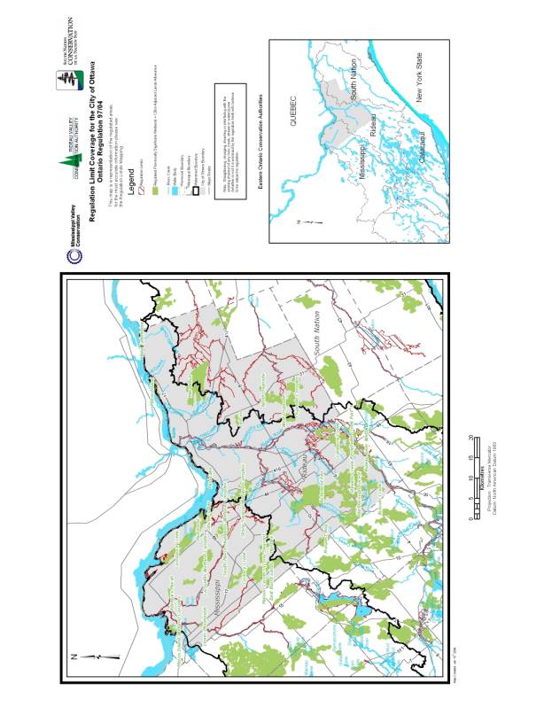
Individual Conservation Authorities are in the process of drafting an Authority-specific regulation to implement this provincial legislation. The Development, Interference with Wetlands and Alterations to Shorelines and Watercourses Regulation affects what and where a Conservation Authority can regulate. A map illustrating the areas within the City of Ottawa subject to Regulation 97/04 is included in document 1. The draft regulation and mapping schedules were presented to the Provincial Peer Review Committee before the end of 2005 and will be forwarded to the Minister of Natural Resources for approval if the Committee considers them to meet the established standards and procedures. The new regulations are intended to come into effect in May of 2006 in all areas of the Province.
The Generic Regulations will provide:
o a fair and accurate basis upon which sound environmental decisions can be mutually made
o updated natural hazard mapping based on current standards and information
o a resource management tool to aid landowners, municipal planners and building departments
o consistency with the Provincial Policy Statement (PPS) under the Planning Act respecting "Natural Hazards" (S. 3.0) and "Natural Heritage" (S. 2.0)
o consistency for regulated areas across Ontario
o streamlined approvals process for amendments by delegating approval and amendment to the Regulation to the Minister of Natural Resources (provided, of course, these amendments conform to the Generic Regulation approved by the legislature.
o generally will not affect current existing land uses.
To understand the changes to the Regulation, current regulations typically govern:
o construction within any area subject to flooding under a regulatory storm event
o placement of fill within fill lines or scheduled fill areas
o interference & alterations to watercourses
The revised Generic Regulation will permit the regulation of:
o development within a regulated area
o interference & alterations to watercourses
o interference & alterations to wetlands (as defined in the Conservation Authorities Act)
o interference & alterations to shorelines (i.e. lakeshores)
Specifically, the revised regulation allows Conservation Authorities to:
o prohibit, regulate or provide permission for straightening, changing, diverting or interfering in any way with the existing channel of a river, creek, stream, watercourse or changing or interfering with a wetland.
o prohibit, regulate or provide permission for development if the control of flooding, erosion, dynamic beaches (none in the Ottawa area), pollution or the conservation of land may be affected by the development.
The following development activities fall under this regulation and must be approved by conservation authorities if within a regulated area:
o the construction, reconstruction, erection or placing of a building or structure of any kind,
o any change to a building or structure that would have the effect of altering the use or potential use of the building or structure, increasing the size of the building or structure or increasing the number of dwelling units in the building or structure,o site grading (note that the Generic Regulations will not restrict the removal of vegetation), or
o the temporary or permanent placing, dumping or removal of any material, originating on the site or elsewhere.
The Generic Regulation complements activities related to the Provincial Planning Act. A permit from the Conservation Authority does not, however, replace building permits or any other permits issued through municipal offices. The 'other applicable law' provisions of the Building Code requires that the Conservation Authority approval be granted first.
The following types of lands are affected if they are located in a regulated area:
o ravines, valleys, steep slopes (escarpment areas),
o wetlands including swamps, marshes, bogs, fens and ponds,
o any river, creek, flood plain or valley land,
o lake shorelines.
Conservation Authorities are currently updating their maps to define what areas may be subject to regulation. The new maps will:
o determine riverine erosion hazard limits on detailed topographic mapping
o depict riverine flooding limits collected from existing studies and mapping
o determine wetland boundaries from Ministry of Natural Resources mapping
o depict the outside limit of all hazards (the dominant hazard)
o illustrate the regulation limit on appropriately scaled mapping including all existing hazard limits and including areas of potential interference to a wetland (Rideau and Mississippi watershed only).
The most significant change to the Regulations is that Conservation Authorities will now be enabled to regulate development in wetlands areas, according to their local needs. The Conservation Authorities are in the process of mapping, for regulatory purposes, all Provincially Significant Wetlands (PSW) that appear on approved Official Plan schedules (including 120 metre adjacent lands where it can be shown that the adjacent lands provide a supporting hydrologic function). Notwithstanding this, wetlands for which mapping schedules have not been prepared may still be subject to regulation if they meet the definition of "wetland" in the legislation. Non-PSW wetlands would be subject to a 30 metre adjacent lands provision. Conservation Authorities are currently developing policies that will direct the implementation of the regulations.
Conservation Authorities have the ability to update their regulations in the future. Future considerations could include: other wetlands and adjacent lands, shorelines of inland lakes, and additional river and stream valleys (in the absence of engineered floodlines).
ENVIRONMENTAL IMPLICATIONS
Regulations to protect the City's sensitive wetlands and watercourses from undue development and interference have significant environmental benefits. The value of wetlands and watercourses for environmental quality (provision of habitat, protection of surface and groundwater quality, flood attenuation, etc) in both the urban and rural areas is well documented. The regulations will allow the local Conservation Authorities to regulate the development and interference of wetlands and alterations to watercourses.
This will reduce the number of inappropriate site alterations that have negative environmental consequences. These regulations will contribute to Ottawa becoming a green and environmentally sensitive city, as identified in the Ottawa 20/20 Growth Management Strategy.
RURAL IMPLICATIONS
The Regulation is of significant importance to the rural areas in the City of Ottawa since it will protect sensitive wetlands and watercourses from undue development and interference. In general, the public supports the idea that wetlands are ecologically important. However, there is some sensitivity in the rural areas about further wetland regulation.
With respect to the proposed wetland additions to the Goulbourn Wetlands Complex, the City of Ottawa has halted any consideration of designating these lands pending further discussion with affected landowners to resolve their questions and concerns in regard to local drainage changes, definition of wetlands, methodology for identifying wetlands and potential impact on property values from wetland identification and Official Plan designation. However, the Rideau Valley Conservation Authority is required by the Province to implement the Generic Regulations prior to spring 2006. Since the proposed additions to the Goulbourn Wetlands Complex are not currently designated on the City's Official Plan as Provincially Significant Wetland (PSW), they will not be mapped for regulatory purposes at this time. However, it should be noted that these wetland areas may still be subject to regulation by the Conservation Authority where they meet the definition of "wetland" as provided in the legislation. The Conservation Authority is currently developing policies that will direct the implementation of the regulations. The policies will be considered for approval by the Conservation Authority Board of Directors in early 2006. Public notification of the policy amendments is anticipated.
CONSULTATION
In the late 1990s, the Province provided opportunity for the public to review amendments to the Conservation Authorities Act and provide feedback which ultimately resulted in the amendments to the Conservation Authorities Act in 1997 and defining the content of Ontario Regulation 97/04 in 2004. This is not a new piece of legislation, but rather amends the already existing regulations.
The local Conservation Authorities (Rideau Valley, Mississippi Valley, and South Nation) are responsible to develop and implement the legislation. In October 2005, the Conservation Authorities hosted a total of 7 public information sessions to present their draft regulation and mapping schedules. Additional information sessions are not anticipated at this time. City staff from the departments of Planning and Growth Management and Utility Services attended a municipal information session hosted by the Conservation Authorities.
The Generic Regulation was also part of the broader discussions on property rights and land use designations which took place during the Rural Summit. These discussions are continuing through the Rural Task Force and will include additional consultation in 2006 through Agricultural and Rural Affairs Committee on such matters as the criteria for wetland evaluation and acquisition and compensation for designated lands and public involvement in the process.
FINANCIAL IMPLICATIONS
The Conservation Authorities finance the implementation of the Generic Regulations through a combination of permit fees and general levy funds. There is no impact on City budget for implementation of the Generic Regulations at this time.
SUPPORTING DOCUMENTATION
Document 1 Areas subject to Regulation 97/04 within the City of Ottawa.
DISPOSITION
The local Conservation Authorities (Rideau Valley, Mississippi Valley, and South Nation) will proceed with the development of Authority-specific regulations, mapping and policies for the Generic Regulations for implementation in May 2006.