|
1. Ottawa River Waterway - CHAT'S DAM
Marine Bypass Project
|
COMMITTEE RECOMMENDATION
That City Council release to the Ottawa River Project
Inc. the balance of the partnership funding for the development of the Chat's
Dam Marine Bypass based upon the completion of each project milestone
referenced in the Financial Implications section of this report.
RECOMMENDATION
DU COMITÉ
Que le Conseil municipal autorise le versement
à la société Ottawa River Project Inc. du reste des fonds de partenariat prévus
pour la réalisation du système de contournement pour bateaux du barrage Chat,
en fonction de chaque étape du projet franchie indiquée dans la section
Implications financières du présent rapport.
Documentation
1.
Planning
and Growth Management, Deputy City Manager’s report dated
31 January 2006
(ACS2006-PGM-ECO-0003)
2.
Extract
of Draft Minute, 07 February 2006.
Report
to/Rapport au :
Corporate Services and Economic Development Committee
Comité des services organisationnels
et du développement économique
and Council / et au Conseil
31 January 2006 / le 31 janvier 2006
Submitted by/Soumis par : Ned Lathrop, Deputy City Manager/Directeur
municipal adjoint,
Planning and Growth Management/Urbanisme et Gestion de la croissance
Contact
Person/Personne ressource : Rob Mackay, Manager, Strategic Projects
Economic Development and Strategic
Projects/Développement économique et Projets stratégiques
(613) 580-2424 x 22632, rob.mackay@ottawa.ca
|
SUBJECT: |
Ottawa
River Waterway - CHAT'S DAM Marine Bypass Project |
|
|
|
|
OBJET : |
VOIE NAVIGABLE DE LA RIVIÈRE DES OUTAOUAIS
- PROJET DE CONTOURNEMENT POUR BATEAUX DU BARRAGE CHAT |
REPORT RECOMMENDATION
That the Corporate Services and
Economic Development Committee recommend that City Council release to the Ottawa River Project Inc. the
balance of the partnership funding for the development of the Chat's Dam Marine
Bypass based upon the completion of each project milestone referenced in the
Financial Implications section of this report.
RECOMMANDATION DU
RAPPORT
Que le Comité des
services organisationnels et du développement économique recommande au Conseil
municipal d'autoriser le versement à la société Ottawa River Project Inc. du
reste des fonds de partenariat prévus pour la réalisation du système de
contournement pour bateaux du barrage Chat, en fonction de chaque étape du
projet franchie indiquée dans la section Implications financières du présent
rapport.
BACKGROUND
Starting in 1991 a series of land based by-passes, using trucks and specialized hydraulic boat trailers, opened 500 kilometres of the Ottawa River to boating. This system is managed by the Ottawa River waterway, whose board members represent the municipalities that wish to participate in the system. Five by-passes were established along the river that link up areas such as Arnprior, Portage-du-fort, Pembroke, Deep River, Rapides-Des-Joachims, Deux Rivières, Mattawa, Temiscaming, Ville-Marie to Notre-Dame Du-Nord. A by-pass around the Dam at the Chat's Falls Power Generation Station would be the sixth by-pass on the river and would extend the route by 50 kilometres to Britannia Bay. This extension would link up the Ottawa boating community, which is estimated at approximately 1600 boats with this northern section of the river.
In July 2002, City Council approved, subject to project milestones, partnership funding for a SuperBuild project to develop the marine by-pass around the Chat's Dam immediately up river from the Village of Fitzroy Harbour. With this approval in place the proponent investigated a number of routes around the dam but ran into difficulty securing a preferred route due to various circumstances and community opposition. In August 2004, staff provided Council with an information report outlining the efforts undertaken to date in regards to the various by-pass routes being considered and evaluated, as well as staff's position on a preferred route. Staff's report identified that the balance of the City funding for this project was not to be made available to the project until this route was approved by all Federal and Provincial review agencies.
Following the August 2004 CSEDC meeting, where significant opposition to the preferred route was raised by the community, Council passed the following resolution:
"That the Corporate Services and Economic Development Committee recommend that City Council strongly urge the Federal and Provincial Government review agencies involved in this project to require a comprehensive environmental assessment".
Council subsequently endorsed this resolution and a letter from the City was submitted to the Federal and Provincial Governments requesting these assessments.
Later when the proponent reviewed the preferred route with the review agencies, it was decided that the more contentious part of the route that is down stream from Chat's Dam be moved from Willola Beach to Mohr's landing where the Quyon Ferry is in operation. This decision was facilitated by the recent availability of an existing residential lot next to the Ferry operation which was now on the market to be sold.
With the route now at Mohr's landing, the Ward Councillor held a new round of community meetings on the revised route and MNR and City staff were on hand to answer questions and address as many issues as possible. With this last modification to the route completed, the proponent submitted their work permit applications to the Ministry of Natural Resources (MNR) for the construction of the upper and lower boat launches in the Ottawa River.
Once these applications were received, MNR screened the project, based on its potential environmental effects, to a Category B Class Environmental Assessment, and undertook a review of the project and the applicants Environmental Study Report (ESR). This review involved consultation with the public, the relevant federal review agencies, Mississippi Valley Conservation Authority, etc. Comments received were considered and where appropriate the applicant was requested to undertake more environmental review and alter the design of the boat launches to mitigate as many concerns as possible. Once this process was completed to the satisfaction of MNR and the review agencies, the final Environmental Study Report was posted for public review.
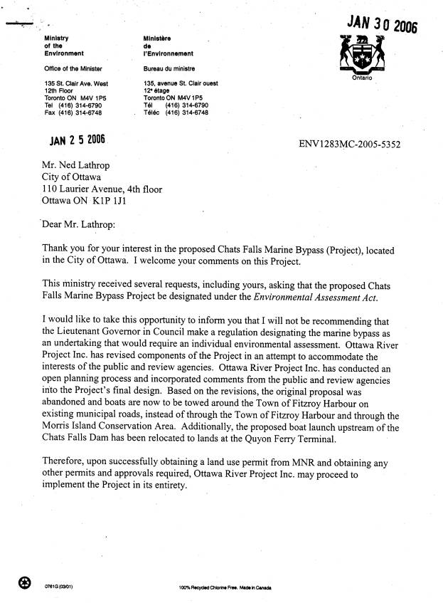
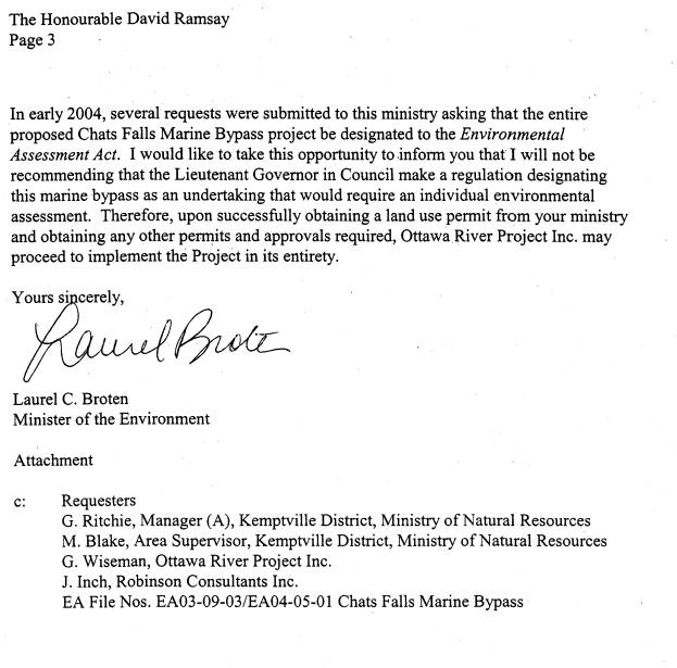
Through the Class Environmental Assessment process and prior to its initiation, several requests for full environmental assessments (including City Council's request) were made to the Ministry of the Environment (MOE). These requests as well as the final ESR were eventually reviewed by MOE and on January 25th 2006 (Document No.1) the Minister of the Environment issued a letter to the City's Deputy Manager of Planning and Growth Management indicating that she would not be recommending that the Lieutenant Governor in Council make a regulation designating the marine bypass as an undertaking that would require an individual environmental assessment.
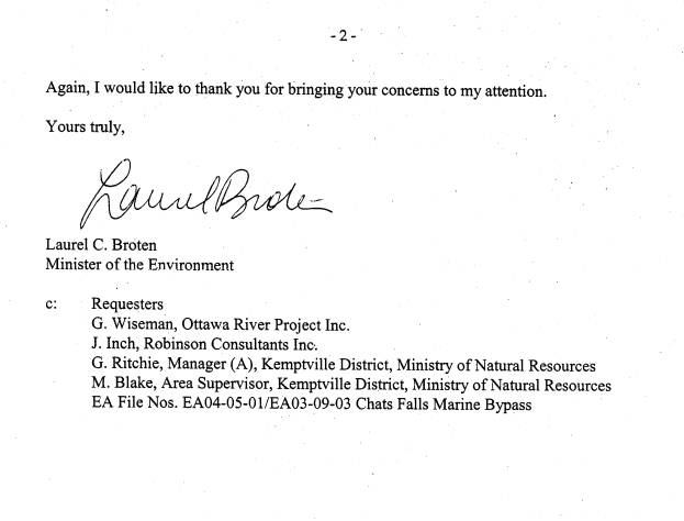
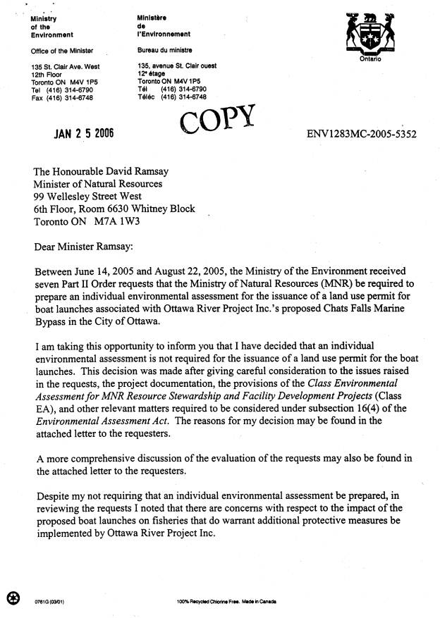
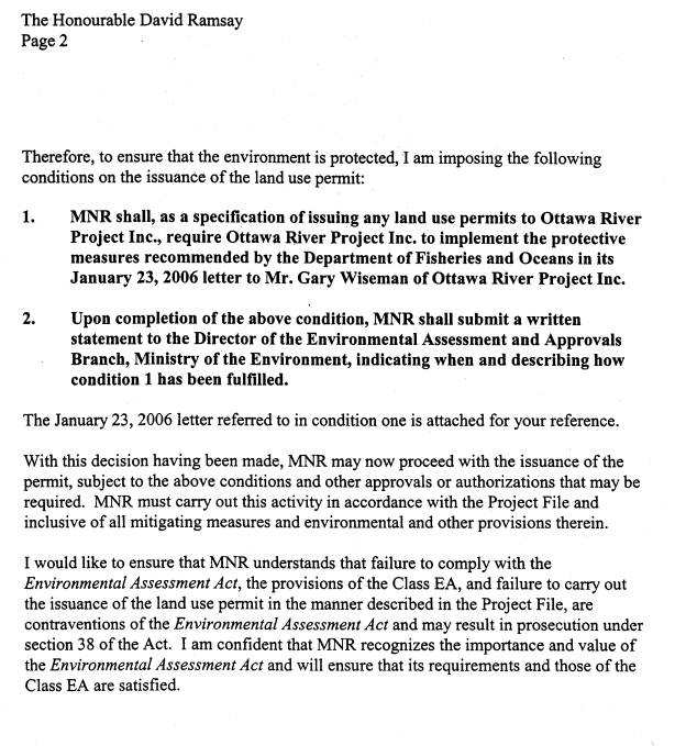
This same Minister also submitted a letter dated January 25th 2006 to the Minister of Natural Resources restating the same recommendation and indicating that this ministry could now issue work permits for the development of the boat launches subject to conditions that established protective measures for fish habitat. Based on this direction, the Ministry of Natural Resources issued on the same day, the work permits for both boat launches subject to a number of conditions which will govern the pending construction activities and protect the environment including the river and its fish habitat. Individuals and organizations that had previously requested a full environmental assessment of the project, were each issued a separate letter from the MOE Minister explaining in detail her position on the concerns they raised and her rationale as to why she was not supporting their requests. These letters were as well dated January 25th 2006.
On the matter of City Council's request for the federal review agencies to require a full environmental assessment of the project, the decision of the MOE Minister has now addressed this matter. Through Ontario's Class Environmental Assessment process, the federal agencies responsible for reviewing a project of this nature were consulted and their comments and conditions were included in the MOE Minister's final approval.
The consultation with DFO and the Navigable Waters Group from Transport Canada occurred over a number of months and contributed to the decision to redesign and relocate the down stream boat launch from Willola Beach to Mohr's Landing. The proposed 150 metre breakwater or berm out into the river at the end of the closed road allowance at Willola Beach was considered problematic and may have triggered a Federal Environmental Assessment.
Once the proposed boat launch was moved to Mohr's Landing, several design iterations of this launch and the up-stream launch at Lavergne Bay were requested and reviewed by the federal review agencies. These changes resulted in a design for the boat launches that received approval from these agencies who will not be triggering a Federal Environmental Assessment for this project. The Navigable Waters' group is satisfied that by staying to the approved design, the boat launches will not cause a navigation hazard in the river. DFO now supports the proposed work at Lavergne Bay and Mohr's Landing, and has stated that fish habitat destruction is not likely to occur with the final design.
With the environmental approvals in place and the work permits issued for the boat launches, the proponent has now requested the balance of the funding from the City so that the project maybe completed prior to March 15th. After this date, the fish spawning season starts and no work will be allowed in the river until July 15th 2006.
DISCUSSION
This report has been submitted to the Corporate Services and Economic Development Committee (CSEDC) and not the Agricultural and Rural Affairs Committee as it is asking for approval for the next steps of an already approved City Council initiative, and the completion of the project is time-sensitive.
The Chat's Dam proposal for a boat by-pass has already risen twice to the CSEDC (2002 and 2004). Since 2002, a total of five sites have been proposed by the proponent and examined on the upstream side of the Chat's Dam. Eight sites were examined on the downstream side. During the assessment process, each site was evaluated in terms of its impacts to aquatic and terrestrial habitats, neighbourhoods, recreational areas, pedestrian and vehicular traffic, safety and archaeology. Other considerations undertaken were the assessment of the expected geotechnical conditions, marine safety and possible sediment loading caused by a breakwater or berm in the river.
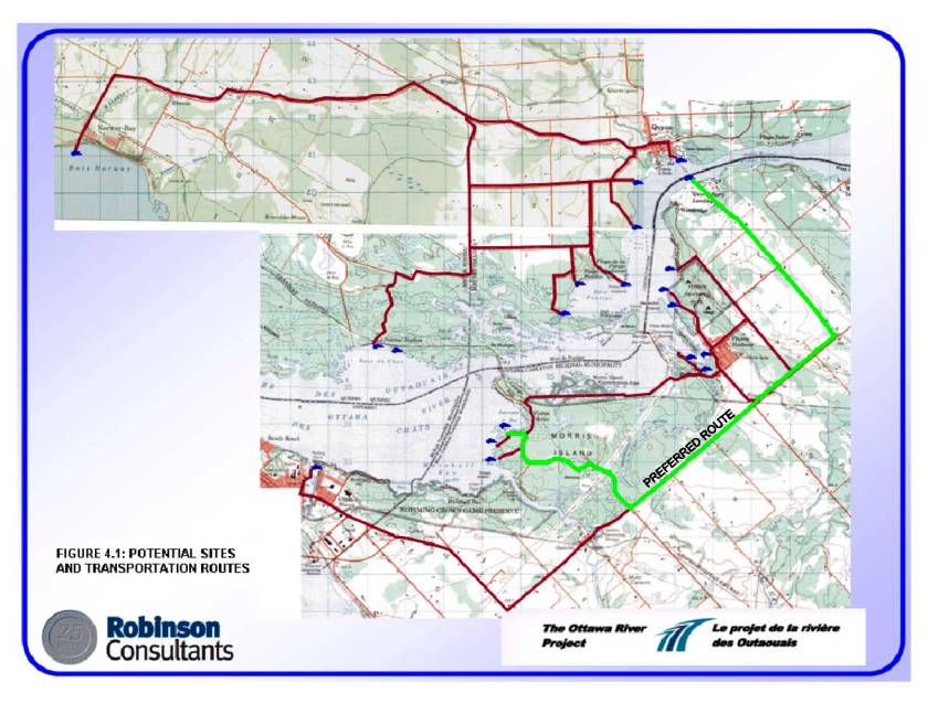
After this review and many iterations of the design, the Lavergne Bay and Ferry Road sites were selected as the preferred alternatives. It was further recommended by the engineering design team that the transportation route for the system follow the City of Ottawa's roads between the two sites and that the recommended route avoid the community of Fitzroy Harbour and the Morris Island Conservation Area. From the downstream boat launch site at Mohr's Landing, the route would follow Ferry Road, to Galetta Side Road to Logger's Way and onto Dewolfe Street to the Lavergne Bay boat launch site (see route map on Document 2).
ENVIRONMENTAL IMPLICATIONS
The launch site is proposed to be located on a lot that will be owned by the Ottawa River Project Inc. This lot is within an area with excellent fish habitat in terms of spawning, rearing and feeding habitats for warm-water sport and coarse fish. In order to minimize negative impacts to this fish habitat, the design of the boat ramp has undergone several changes. The ramp will be made of pre-fabricated concrete beams set into a steel frame and placed onto a rock filled base. This structure will be located on a small underlying bedrock outcrop which typically provides little value to fish habitat. Broken rock will also be added to the slopes of the ramp to protect it from wave actions. Concrete abutments will be placed on the shore above the high-water mark with broken rocks placed around the abutments to protect them from ice damage.
The construction of the boat launch will require only minimal in-water excavation (30cm) due to the presence of the underlying bedrock. The design will consist of a boat slip that extends into the water a distance of 7.5 meters at the high water level and will be 4.0 meters wide. The rocky reef habitat is expected to recolonize with aquatic vegetation which in turn will provide excellent fish habitat in terms of cover and spawning habitat for such species as sunfish, minnows and yellow perch.
Although not required by DFO, the proponent will undertake in Lavergne Bay a Habitat Improvement Project, which further enhances the fish habitat in this area. This will involve enlarging an existing embayment by 132 square metres. The new area will be dug to two depths, a shallow depth of .75m around the perimeter and a deeper depth of 1.5m in the middle. The new habitat will be supplemented by anchoring one large woody structure and by placing a boulder cluster within the new shallow area.
By staying to the boat launch design and respecting the construction regulations and other requirements provided to the proponent, DFO has stated it is unlikely that the undertaking will result in "harmful alterations, disruptions or destruction (HADD)" of fish habitat, which is prohibited unless authorized by this review agency.
The lot for the proposed boat launch is currently obscured from view from Dewolfe Street. The site will be gated and secured after the hours of operation to prevent unauthorized access and potential vandalism. This will also prevent unwanted traffic on Dewolfe Street during the time when the Boat By-Pass is closed. No overnight docking will be permitted on this site and boaters will be directed by site signage to travel to Arnprior where such facilities are available.
Mohr's Landing
According to the approved ESR, the habitat at Mohr's Landing at the end of Ferry Road is very homogeneous with disturbances from the construction and current operation of the ferry accounting for the primary differences in habitat type with Lavergne Bay. Given the disturbed nature of this proposed downstream landing area, the rare quillworts identified in Quyon Bay by Dan Bruton in 1992 are not likely to be at this proposed landing area and were not observed in the 2004 field survey. A follow-up survey was conducted in July 2005 for this area. The survey reaffirmed earlier findings and stated that the dock design and location should remain as indicated in the Robinson Consultants drawings.
The preferred launch site on the lot to be acquired by the Ottawa River Project Inc. would be in an existing area that is currently lacking in vegetation as a result of disturbances created by the ferry operation and the annual installation of a removable dock by the property owner.
The construction of the boat launch at the Mohr's Landing location will likely require the banks and some sediment to be excavated in the river. This material will be replaced with pre-fabricated concrete beams set into a steel frame and placed on a rock base. Broken rock will be added to the side slopes for ice and wave action protection. Due to the water depth changes caused by the dam operation, the ramp structure will consist of two distinct parts. The first is a level ramp that extends from the shore, but is located at an elevation that is below the high water mark and flooded for most of the year. This portion is dry only in the low water periods of the Summer when the water is totally controlled by the dam. The second part of the ramp is the more steeply constructed boat launch ramp that is under water year-round.
Similar to Lavergne Bay, the proponent will undertake a fish habitat enhancement project at this location which is not required by the approval authorities. This will involve excavating a new 212 square meter embayment upstream of the proposed ramp location. The shoreline on this portion of the lot will be planted with native shrubs and trees that eventually will provide overhanging vegetation and canopy cover along the edge of the embayment. The in-water habitat will be enhanced through the planting of aquatic plant specimens secured from the adjacent coastal wetland.
In the end, the construction of the boat launch ramp will change the existing disturbed area from fine granular material with no vegetation to an aquatic vegetation with a rock reef habitat. The broken rock will result in an increase in habitat diversity that will create new spawning and nursery habitat for some sunfish and minnow species as well as general cover for a variety of fish species. The final ESR report states that if the mitigation measures are followed, environmental impacts will be minimized and/or eliminated and there will be an overall net gain in fish habitat diversity in Quyon Bay.
No blasting will be required as part of the in-water work as rock removal will be made possible through hoe-ramming. The resultant rock will be used as shoreline protection for the ramp.
The lot that is proposed to be purchased for the boat launch at Mohr's Landing is currently developed with a single family home. The shoreline and road access areas have been landscaped by the home owner over the years and no terrestrial habitats of note were identified through the surveys. The total length of the ramp will be 35 meters out from the shoreline at the highwater mark. An existing driveway access to Ferry Road will be used by the Boat By-Pass and for security purposes a gate will be erected and locked following the operating hours of the facility. There will be no overnight docking permitted at the site. Boaters will be directed to travel to the marina at Quyon, directly across the river, where such facilities are available.
Business Plan
A revised four-year pro forma for the proposed Chat's Dam boat by-pass has been reviewed by staff. Revenues include day and season lift passes with expenses taking the form of wages, benefits, maintenance, storage, insurance, fuel, licenses, etc.
The Chat's Dam Bypass has the benefit of joining an existing system with a long history of continuous operational experience. Operating from mid-June to shortly after Labour Day, the Ottawa River Project Inc. has benchmarked its business plan on the past costs and revenues generated at the other sites with escalation factors that take into consideration the rising costs of fuel, insurance and the distance of the new route. The by-pass aims to operate at a break-even or better level and will tailor expenses to follow demand and hence income. Boater traffic is weather dependent and experience has shown that the strictest control of costs to match income will be required. The larger expenses of fuel and staff will vary directly with the actual traffic being experienced hence costs can be contained when weather or other factors limit traffic.
While other by-passes particularly in the North and Quebec have access to programs targeted at increasing tourism and thus defraying operating costs, the Ottawa River Project Inc. has stated that they will not need a similar operational subsidy for the Chat's by-pass. Staff acknowledge this position and have indicated to the proponent that the City has only agreed to assist the proponent with the development portion of the project and not subsidize any operational costs. As well should the by-pass operator declare bankruptcy, the assets, according to the proponent, of the Ottawa River Project Inc. will be marketable and the infrastructure designed for an extended life cycle. Operational experience up the river indicates that over time the local community does accept and utilize these facilities due to their proximity and convenience.
CONSULTATION
The
Ferry Road site was originally included as one of the downstream launch site
alternatives in the Chats Falls Marine By-Pass Project Design Report however
since no access land was available, the site was removed as an option. In
December 2004, the parcel of land adjacent to the Quyon Ferry dock was put up
for sale. Upon further investigation, it was determined that from an aquatic
habitat perspective, the site appeared to be workable. In January 2005 the Ward
Councillor was advised that this would now become the preferred downstream
launch site. A public meeting was called for January 14th, 2005. Letters were
hand delivered to each resident on Ferry Road as well as Aylwin, Dewolfe,
Galetta, Bradhams Side and Old Birch Roads. The intent of the January meeting
was to advise residents of this new preferred downstream site adjacent to the
Quyon Ferry and to confirm that the Morris Island Conservation Area and Willola
Beach routes were no longer being considered for the project. It was also
stated, that the project did not intend to utilize the streets of Fitzroy
Harbour thus removing some of the concerns expressed by area citizens.
With
the introduction of Ferry Road as the preferred site, new concerns were expressed
on the potential impact for emergency response vehicles being able to access
residents' homes because of blocked laneways from the waiting ferry and boat
traffic. A traffic impact study to measure the effects of the ferry operation
might have on the proposed boat launch was requested.
A
follow-up meeting was then held on March 3, 2005 where representatives from
Fire, Paramedics, Police, Bylaw and Traffic and Parking as well as a
representative from MNR were on-hand to respond to questions and concerns
raised at the January 14th 2005 meeting. It was explained that
approvals were required on both launches sites by MNR under their Resource
Stewardship and Facility Development Projects (Class EA) process. Residents
were invited to submit their name and contact information in order to receive a
notice prior to the approval process. The Public Consultation Notice began in
March, 2005 which was followed by a 3 month Class Environmental Assessment.
At
the March meeting concern was also raised regarding alleged rowdiness of the
patrons leaving the ferry on their return trips from Quyon and the impact the
boat travellers might have in contributing to this problem. It was pointed out
that the Boat By-Pass closed at sunset prior to when most patrons would be returning
from Quyon. The police reported that there had only been few complaints
received regarding rowdiness to date.
In
response to a query on the possible migration of zebra mussels into the area by
boat traffic, it was stated that the conditions in the river for the zebra
mussels to survive do not exist save and except where other rivers rich in
calcium enter the Ottawa River. Infestations beyond these points in the Ottawa
River are not known to exist and are unlikely to occur.
Another
concern expressed was the possibility of boaters dumping raw sewage into the
river. It was noted that signage directing boaters to alternate facilities
where the appropriate services exist would be posted at the launches. The MNR
representative explained that both sites would be reviewed by the appropriate agencies including MNR and
approval was conditional on these agencies being on-side with the project.
Traffic
At the March 3rd
meeting, City traffic officials identified that given the anticipated traffic
of 5‑10 trips/day using the launches, the road system could easily handle
the added traffic volume caused by the trailers ferrying boats between the
launch points. The Traffic Department assured the residents that they would be
working with the proponent to address City policies. Although comments were
received that the existing signs at Mohr's Landing prohibiting parking in
certain locations were not working, Bylaw indicated that extensive patrols had
been conducted in this area and no complaint or tickets had been issued in the
last four years.
Traffic
and Parking Operation staff also met with adjacent residents at Mohr's landing
on March 13 and April 29th, 2005. As a result of the public consultation
and various individual meetings, the following measures were taken:
- the speed limit was reduced from 80 km/h to 50 km/h on Ferry Road approaching the ferry entrance.
- signage was repositioned to improve
its visibility.
- a "No Stopping Zone" was implemented on the east side of Ferry Road approaching the ferry entrance.
- "Do Not Block Driveway" signs were installed and supplemented with a special cross-hatched pavement markings at the two driveway entrances located on the east side of Ferry Road.
- other pavement markings on Ferry Road
were enhanced by the City as well.
During
the 2005 Canada July long weekend, the Traffic Department also undertook a
study to examine the queuing pattern of the Quyon Ferry operation. The survey
noted no serious issues. For the most part, drivers honoured the "Do Not
Block Driveways" signs which have allowed the few residents that live at
Mohr's Landing to access their properties via the side laneways off of Ferry
Road.
Since
the inception of this project in 2002, there have been seven public meetings
hosted by the Ward Councillor and three Open Houses hosted by the proponent.
Meetings
were also held with the operator of the Quyon Ferry and operators along the
existing system to obtain information and to better understand the current
operational practices. To improve his knowledge of the project, the Ward Councillor also travelled to
Pembroke with City staff to meet with the entire membership of the waterway
including the municipalities at the extreme northern end of the system. At this
meeting the membership expressed the importance of completing the waterway to
Ottawa for their respective jurisdictions.
Next
steps
The
proponent has now received the work permits for both launch facilities. Subject
to finalizing legal agreements and securing the remaining monies from the
various funding agencies, the proponent will initiate construction of the
launch facilities and complete the in-water works before the fish spawning
season starts on March 15th. Staff will monitor the progress of the
project and release the City's funds once the project reaches the various
project milestones identified in this report.
FINANCIAL IMPLICATIONS
The following project milestones were approved by City Council in July of 2002. Of this total amount, $50,000 has been released to date to assist the proponent in the preparation of the background documents. The milestones are as follows:
Project
Milestones
1. Seed funding, research and background documentation $ 50,000 (paid)
2. Final route selection with all legal agreements in place $ 100,000
3. Construction of boat launch ramps started $ 75,000
4. Issuance of tender for the operational equipment $ 50,000
5. Completion of all remaining works $ 75,000
Total $350,000
The balance of the partnership funding is available in internal order 900003, Economic Affairs.
SUPPORTING DOCUMENTATION
Document 1 Letters of Approval from the MOE Minister
Document 2 Route Map
DISPOSITION
Upon acceptance of this report, staff will proceed with the issuance of the City funds based on the proponent reaching the project milestones contained in this report.
LETTERS OF APPROVAL FROM
MOE MINISTER DOCUMENT 1