|
2. zONING - 582 moodie drive and 2978 richmond road |
Committee recommendations
That Council approve:
1. An amendment to the former Nepean Zoning By-Law to change the
zoning of the easterly portion of 582 Moodie Drive from a R3 - Residential
Third Density Zone to R5C - Residential Fifth "C" Density Zone as
shown as Area A in Document 1 and as detailed in Document 2; and
2. An amendment to the former Nepean Zoning By-Law to change the
zoning of the westerly portion of 582 Moodie Drive and 3978 Richmond Road from
a R3 - Residential Third Density Zone to R6A (H) - Residential Sixth
"A" Density Zone with a holding designation, as shown as Area B and C
in Document 1 and as detailed in Document 2.
Recommandations du Comité
Que le Conseil approuve :
1. une modification du Règlement de zonage de
l'ancienne Ville de Nepean ayant pour effet de changer de R3 (Zone
résidentielle de troisième densité) à R5C (Zone résidentielle de cinquième
densité C) le zonage de la partie est de la propriété sise au 582 de la
promenade Moodie, représentée par l'aire A dans le document 1 et décrite en
détail dans le document 2;
2. une modification du Règlement de zonage de
l'ancienne Ville de Nepean ayant pour effet de changer de R3 (Zone
résidentielle de troisième densité) à R6A(H) (Zone résidentielle de sixième
densité A, avec désignation d'aménagement différé) le zonage de la partie ouest
de la propriété sise au 582 de la promenade Moodie et au 3978 du chemin Richmond,
représentée par les aires B et C dans le document 1 et décrite en détail dans
le document 2.
For the information of
council
Committee Chair Hume read a statement required under the Planning Act, wherein he advised that anyone who intends to appeal this proposed Zoning By-Law Amendment to the Ontario Municipal Board (OMB), must either voice their objections at the public meeting, or submit their comments in writing prior to the amendment being adopted by City Council. Failure to do so could result in refusal/dismissal of the appeal by the OMB.
Pour la gouverne du Conseil
Le conseiller Hume, président du
Comité, a lu un énoncé en vertu de la Loi sur l’aménagement du territoire,
stipulant que quiconque souhaite interjeter appel auprès de la Commission des
affaires municipales de l’Ontario (CAMO) de la modification proposée au
Règlement de zonage doit exprimer ses objections à la réunion publique ou
soumettre ses commentaires par écrit avant que la modification ne soit adoptée
par le Conseil municipal, faute de quoi son appel pourrait être rejeté par la
CAMO.
Documentation
1. Deputy City Manager's report (Planning
and Growth Management) dated
1 February 2006 (ACS2006-PGM-APR-0022).
Report
to/Rapport au :
Planning and Environment Committee
Comité de l'urbanisme et de
l'environnement
and Council / et au Conseil
01 February 2006 / le 01 février 2006
Submitted
by/Soumis par : Ned
Lathrop, Deputy City Manager /
Directeur municipal adjoint
Planning and Growth Management / Urbanisme et Gestion de la croissance
Contact Person/Personne ressource : Karen Currie, Manager / Gestionnaire
Development Approvals / Approbation des demandes d'aménagement
(613) 580-2424 x28310, Karen.Currie@ottawa.ca
|
SUBJECT: |
ZONING - 582 Moodie Drive and 3978
Richmond road (FILE
NO. D02-02-05-0065) |
|
|
|
|
OBJET : |
REPORT RECOMMENDATIONS
That the Planning and Environment Committee recommend Council approve:
1. An amendment to the former Nepean Zoning By-Law to change the
zoning of the easterly portion of 582 Moodie Drive from a R3 - Residential
Third Density Zone to R5C - Residential Fifth "C" Density Zone as
shown as Area A in Document 1 and as detailed in Document 2; and
2. An amendment to the former Nepean Zoning By-Law to change the
zoning of the westerly portion of 582 Moodie Drive and 3978 Richmond Road from
a R3 - Residential Third Density Zone to R6A (H) - Residential Sixth
"A" Density Zone with a holding designation, as shown as Area B and C
in Document 1 and as detailed in Document 2.
RECOMMANDATIONS DU
RAPPORT
Que le Comité de l'urbanisme et de
l'environnement recommande au Conseil d'approuver :
1. une modification du Règlement de zonage de
l'ancienne Ville de Nepean ayant pour effet de changer de R3 (Zone
résidentielle de troisième densité) à R5C (Zone résidentielle de cinquième
densité C) le zonage de la partie est de la propriété sise au 582 de la
promenade Moodie, représentée par l'aire A dans le document 1 et décrite en
détail dans le document 2;
2. une modification du Règlement de zonage de
l'ancienne Ville de Nepean ayant pour effet de changer de R3 (Zone résidentielle
de troisième densité) à R6A(H) (Zone résidentielle de sixième densité A, avec
désignation d'aménagement différé) le zonage de la partie ouest de la propriété
sise au 582 de la promenade Moodie et au 3978 du chemin Richmond, représentée
par les aires B et C dans le document 1 et décrite en détail dans le document
2.
BACKGROUND
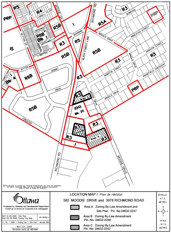
This Zoning By-law amendment application pertains to three parcels of land located between Richmond Road and Moodie Drive in the community of Bells Corners, more commonly referred to as the Richmond –Moodie triangle (Document 1). Two of the parcels are vacant and the third, which fronts onto Richmond Road, is occupied by a single detached dwelling. The parcels are flanked by the existing neighbourhoods of Westcliffe to the west and Arbeatha Park to the east. The triangle is occupied by five single detached dwellings on Moodie Drive and two dwellings on Richmond Road.
A site plan application has been processed concurrent with the zoning circulation for the eastern parcel at 582 Moodie Drive. This parcel will accommodate 53 townhouses on a private street. Details respecting the design, traffic and servicing issues have been addressed through the site plan approval process. The zoning and site plans proposals were discussed with abutting landowners and communities at an open house meeting in July 2005. No proposals have been received for the parcel at 3978 Richmond Road or the western section of 582 Moodie Drive.
DISCUSSION
Official Plan Conformity
The parcels are designated as "General Urban Area" in the City Council Approved Official Plan and "Residential" within the former City of Nepean Official Plan.
Details of Proposed Zoning
All three parcels are currently zoned as R3 - Residential Third Density Zone. Area A on Document 1 is proposed to be zoned to a R5C Block (XX) - Residential Fifth "C" Density Zone Exception Zone to permit the development of 53 townhouses. The zone exception is required to increase the density from the permitted 50 units per hectare to 63 units per hectare, to permit parking spaces with a dimension of 2.6 metres by 5.2 metres whereas the by-law requires 2.6 metres by 5.5 metres, and to allow for a 1.8 metre encroachment of a deck into the required yard whereas the by-law allows a 1 metre encroachment.
Areas B and C on Document 1, are proposed to be zoned as R6A (H)(Block XX) - Residential Sixth "A" Density Holding Zone, to permit medium density residential development. The exception will add townhouses, developed in accordance with the provisions of the R5, R5A, R5B or R5C zone.
In 1996, the former City of Nepean conducted a land-use feasibility study of the Richmond-Moodie triangle lands in response to development pressures to permit commercial enterprises on these lands. One of the purposes of the study was to determine policies that could guide future development decisions within this area. The basis for preparing the land use concepts was guided by the Bells Corners Secondary Plan, which was adopted, after extensive public input, by Nepean Council in 1993. The Plan designated these lands as suitable for medium-density residential development. The 1996 study identified a number of areas of concern for the community. It was recognised that since two arterial roads bordered the area, it was not suitable for single detached homes, however the study determined that any new development would have to be sensitive to the existing single-family homes and surrounding community. Further, pedestrian movements between Richmond Road and Moodie Drive were, and continue to be identified as major issues to be addressed by any development proposal. Traffic concerns related to cut-through traffic and a desire for new development to alleviate some of this problem were also identified as issues. Since that time, traffic signals have been installed at Seyton Drive and Richmond Road, however, the issue of a pedestrian connection to Moodie Drive, especially for students attending D. Aubrey Moodie School, will need to be addressed by any development proposals for these lands.
The preferred land use concept that was selected
consisted entirely of residential development. The other two options included
varying degrees of commercial development, and these were overwhelmingly
rejected thorough the public consultation process. The latter options were also
lacking in merit from a land use compatibility perspective. The outcome of this
study was a re‑enforcement of the medium density residential policies for
this triangle of land in the Bells Corners Secondary Plan. The City of Nepean
Official Plan adopted in 2000, incorporated an area-specific policy regarding
the triangle, which in effect stated that these lands were appropriate for
medium density development.
Thus, the proposed zoning for the lands currently identified
as Areas B and C in Document 1, is in conformity with the above-noted policies
and will facilitate the development of townhouses and stacked townhouses.
Issues relating to pedestrian movements though the area, traffic concerns and
building design will be addressed through the site plan approval. The Holding
symbol attached to the zoning for the parcels identified as Areas B and C will
enable dialogue to occur with the surrounding community at the site plan stage,
and will only be removed when these issues have been adequately mitigated.
The site at 582 Moodie Drive, identified as Area A
in Document 1, is at the very periphery of the triangle abutting the Greenbelt.
The proposal for 53 townhouse units meets with the objectives and policies of
the former City of Nepean Official Plan and the current City Council Approved
Official Plan regarding residential intensification and compatibility. The
development is also physically separated from the existing homes along Moodie
Drive and is not expected to visually impact on them. It also represents an
efficient use of the parcel of land. The plans for these units have been the
subject of a site plan application, which is nearing the stage of final
approval (see Document 3). The development proposal has also been through a
consultation process whereby staff and the community have evaluated the
suitability of the units. A level of consensus has been achieved on the
development proposal.
The Department supports the recommended approach regarding the proposed zoning for Areas A, B and C. The amendments will enable the development of 53 townhouse units and future residential units on lands that will have access to existing infrastructure. The amendments will also further the objectives of the City Council Approved Official Plan, which strongly promotes infill development within the urban area with attention to compatibility issues.
CONSULTATION
Notice of this application was carried out in accordance with the City’s Public Notification and Consultation Policy. The Ward Councillor is aware of this application and the staff recommendation.
An Open House Meeting, attended by 19 residents, was held on June 27, 2005. There was general acceptance of the proposal among attendees. However, staff also received three e-mails and one letter on this application, which itemized concerns and comments. These are summarized in Document 4.
APPLICATION PROCESS TIMELINE STATUS
The application was not processed by the "On Time Decision Date" established for the processing of Zoning By-Law amendments due to issues surrounding the ownership of the parcel of land subject to this amendment. These issues now have been resolved.
SUPPORTING DOCUMENTATION
Document 1 Location Map
Document 2 Details of Recommended Zoning
Document 3 Conceptual Site Plan for Area A
Document 4 Consultation
Details
DISPOSITION
Corporate Services Department, City Clerk's Branch to notify the owner's agent (Tim Wilkins, Cunningham, Swan, Carty, Little and Bonham, Suite 201, 1473 John Counter Blvd. Kingston Ontario. K7M 8Z6), Signs.ca, 866 Campbell Avenue, Ottawa, ON, K2A 2C5 and Ghislain Lamarche, Program Manager, Assessment, Financial Services Branch (Mail Code: 26-76) of City Council’s decision.
Planning and Growth Management Department to prepare the implementing by-law, forward to Legal Services Branch and undertake the statutory notification.
Corporate Services Department, Legal Services Branch to forward the implementing by-law to City Council.
Document 1
LOCATION MAP
Document 2
DETAILS OF RECOMMENDED ZONING
The following zoning changes
are proposed for the lands shown on Document 1 attached:
1.
That Area A on Document 1 (PIN: 04632 – 0247) be
rezoned from a Residential Third Density - R3 Zone to Residential Fifth
Density - R5C Zone Block (XX).
Further, notwithstanding Section 5:18,
5:20:3and Section 6:5C:2 to the contrary; for the lands zoned R5C Zone Block
(XX), the following additional provision shall apply:
a. Parking
Spaces shall have a minimum width of 2.6 metres and a minimum length of 5.2
metres
b. Decks,
unenclosed patios or landings are allowed to project to a maximum of 1.8 metres
into the required yards
c. DENSITY(maximum)
63 DWELLING UNITS per hectare
Notwithstanding the provisions of Sections 5:9
to the contrary, the land zoned R5C Block (XX), shall continue to be considered
as one LOT for zoning purposes despite the lawful severance of a LOT pursuant
to the Planning Act or Condominium Act.
2.
That Areas B and C on
Document 1 (PIN: 04632-0248 and PIN: 04632 - 0252 respectively) be rezoned from
a Residential Third Density - R3 Zone to Residential Sixth Density R6A Zone
Block (XX).
Further, notwithstanding Section 6:6A:1 and
6:6A:2 to the contrary; for the lands zoned R6A Block (XX), the following
additional provisions shall apply:
Permitted Uses:
All uses permitted in the R5A, R5B and R5C
Zones subject to the zone requirements of the respective zone
Dwellings Multiple Attached.
On any lands zoned R6A Block (XX) with a
holding (H) designation, no person shall use any building or structure or land
for any purpose other than that for which it was used on the date of passing of
the By-law for these lands. An amendment to By-law 100-2000 to remove the
Holding provision from any portion of the areas denoted by the “H” suffix shall
be conditional upon the following:
-
The submission and approval of a site plan application
to the satisfaction of the City of Ottawa.
Notwithstanding the provisions of Sections 5:9
to the contrary, the land zoned R6A Block (XX), shall continue to be considered
as one LOT for zoning purposes despite the lawful severance of a LOT pursuant
to the Planning Act or Condominium Act.
3.
That Schedule B3 of Zoning By-law 100-2000 be amended
as follows:
- Area A on Document 1 be changed from R3 to
R5C Block (XX);
- Area B and C on Document 1 be changed from R3 to R6A (H) Block (XX). [U2]
Document 3
CONCEPTUAL SITE PLAN FOR AREA A

Document 4
CONSULTATION DETAILS
NOTIFICATION
AND CONSULTATION PROCESS
Notification and public consultation was undertaken
in accordance with the Public Notification and Public Consultation Policy
approved by City Council for Zoning By-law Amendments. At the time of writing of this report, one
public meeting was held in the community at the Centennial Branch of the Ottawa
Public Library. Following is a summary of the comments received at the meeting
and through e-mail correspondance on the application.
SUMMARY OF PUBLIC INPUT
Concern:
Neighbours were concerned that blasting may cause cracks in their basements.
Response:
It was stated that the proposal would not employ blasting to excavate the foundations of the new units. However, if it were necessary, then pre-and post-construction monitoring will be undertaken.
Concern:
Drainage from the site and potential flooding of rear yards abutting the development.
Response:
Stormwater management studies and proposed grading will ensure that this does not occur. This is addressed through the engineering review that requires new developments to ensure the grading of a site does not impact adjacent properties with surface runoff.
Concern:
The additional traffic from the development will add to traffic problems in the community. The traffic patterns in the immediate area need to be looked at to eliminate the vehicular cut-through that is being experienced on Arnold Drive.
Response:
Traffic volumes were examined and the roadways are deemed capable of handling the additional volume from this and the future development of the remaining vacant lands. With respect to traffic movements from Richmond Road onto Arnold Drive, this development is not expected to exacerbate the existing situation.
Concern:
Will the City supply clean drinking water if the wells serving the existing homes in the area are contaminated by the surrounding development?
Response:
The City does not expect that existing wells will be impacted by the proposed development. If the residents would like to connect to the new services that will be installed in the vicinity of their homes, they will be responsible for all costs associated with the extension of the services.
Concern:
Stony Swamp Wetland Complex covers a large area to the west and south of the site. Has there been any study to determine why this property has been left out. Will this development have any negative impacts on the functions of the surrounding wetland?
Response:
The Official Plan Schedule B designates the area immediately surrounding the site as Natural Environment Area(NEA). The NEA designation is intended to cover all of the Greenbelt Area, which surrounds much of the communities in this area. The designation has been refined based on further analyses of NEA’s throughout the City and the subject development parcel was not a candidate site selected for further evaluation. The Stony Swamp designated wetland area does lie within the abutting NEA, however, the limits of the wetland are not in close proximity to the development site. This development will not disturb the features in the surrounding NEA as identified in the Environmental Impact Statement prepared by Muncaster Environmental Planning. There is no interaction between the site and the Conservation Area lands and the core of Stoney Swamp is well buffered from the site.
Concern:
There is already a significant amount of high density housing in the area. There needs to be a balance between the low medium and high developments the community. This development will also not provide additional open space, and will place an additional burden on existing facilities.
Response:
The proposal conforms to the Official Plan and former Secondary Plan policies in place for this community, specifically as they relate to the provision of a mix of housing types and the promotion of compatible residential intensification. The City does, to the extent permitted by legislation and policies, encourage a mix of developments. Furthermore, the community is well served by parks and open spaces and this proposal does not generate the need for additional such facilities internal to the development.