|
3. zONING - 4241 BARNSDALE ROAD |
Committee recommendation
That Council approve an amendment to
the former City of Nepean Zoning By-Law to change the zoning of
4241 Barnsdale Road from MX (Mineral Extraction) to MX Block X (Mineral
Extraction-Block X) as shown in Document 1 and as detailed in Document 2.
Recommandation du Comité
Que le Conseil
approuve une modification au Règlement de zonage de l'ancienne Ville de Nepean,
afin de faire passer le zonage du 4241, chemin Barnsdale de MX (Extraction
minérale) à MX Bloc X (Extraction minérale--Bloc X), tel qu'illustré dans le
Document 1 et exposé en détail dans le Document 2.
For the information of
council
Committee Chair Hume read a statement required under the Planning Act, wherein he advised that anyone who intends to appeal this proposed Zoning By-Law Amendment to the Ontario Municipal Board (OMB), must either voice their objections at the public meeting, or submit their comments in writing prior to the amendment being adopted by City Council. Failure to do so could result in refusal/dismissal of the appeal by the OMB.
Pour la gouverne du Conseil
Le conseiller Hume, président du
Comité, a lu un énoncé en vertu de la Loi sur l’aménagement du territoire,
stipulant que quiconque souhaite interjeter appel auprès de la Commission des
affaires municipales de l’Ontario (CAMO) de la modification proposée au
Règlement de zonage doit exprimer ses objections à la réunion publique ou
soumettre ses commentaires par écrit avant que la modification ne soit adoptée
par le Conseil municipal, faute de quoi son appel pourrait être rejeté par la
CAMO.
Documentation
1. Deputy City Manager's report (Planning
and Growth Management) dated
1 February 2006 (ACS2006-PGM-APR-0060).
Report
to/Rapport au :
Planning and Environment Committee
Comité de l'urbanisme et de
l'environnement
and Council / et au Conseil
01 February 2006 / le 01 février 2006
Submitted by/Soumis par : Ned
Lathrop, Deputy City Manager /
Directeur municipal adjoint
Planning and Growth Management / Urbanisme et Gestion de la croissance
Contact Person/Personne ressource : Karen Currie,
Manager / Gestionnaire
Development Approvals / Approbation des
demandes d'aménagement
(613) 580-2424 x28310,
Karen.Currie@ottawa.ca
|
SUBJECT: |
|
|
|
|
|
OBJET : |
REPORT RECOMMENDATION
That the Planning and Environment
Committee recommend Council approve an amendment to the former City of Nepean
Zoning By-Law to change the zoning of 4241 Barnsdale Road from MX (Mineral
Extraction) to MX Block X (Mineral Extraction-Block X) as shown in Document 1
and as detailed in Document 2.
RECOMMANDATION DU RAPPORT
Que le Comité de l'urbanisme et de l'environnement
recommande au Conseil d'approuver une modification au Règlement de zonage de
l'ancienne Ville de Nepean, afin de faire passer le zonage du 4241, chemin
Barnsdale de MX (Extraction minérale) à MX Bloc X (Extraction minérale--Bloc
X), tel qu'illustré dans le Document 1 et exposé en détail dans le Document 2.
BACKGROUND
An
application to amend the Zoning By-law has been submitted for 4241 Barnsdale
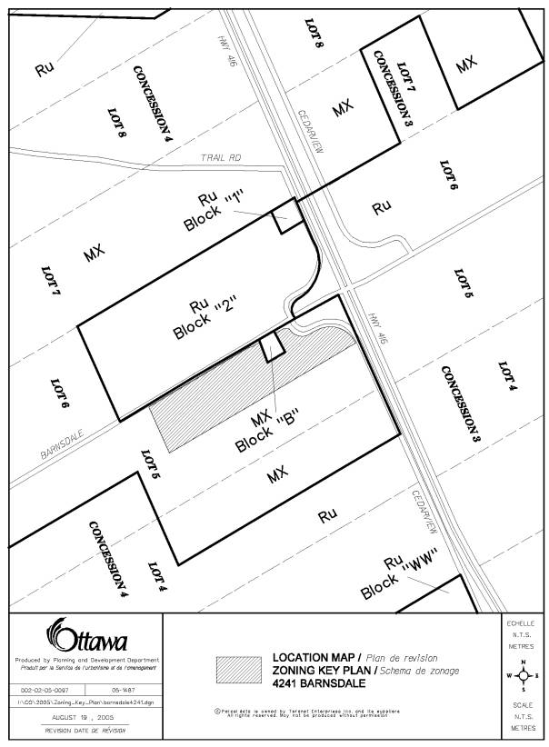
Road on an 8.45 hectare site located on the south side of Barnsdale Road, west
of Cedarview Road and Highway 416, and east of Moodie Drive. The site currently
is vacant and is characterized by dense young vegetation. The surrounding uses include: undeveloped
rural land to the south, hydro corridor to the west, municipal landfill to the
north, and agricultural uses across Highway 416 to the east. The applicant has requested a Zoning By-law
amendment to add a "Mini Warehouse and Public Storage" as an
additional permitted use to the Mx (Mineral Extraction) zone.
DISCUSSION
Official Plans
The site is designated as "General
Rural" in the City Council Approved Official Plan and the former Regional
Official Plan. This designation permits
a variety of land uses that are appropriate for a rural location. Specifically, it allows for non-agricultural
uses that due to their land requirements or nature of their operation, would
not be more appropriately located within urban or Village locations. The development must be in keeping with the
surrounding rural character and landscape.
The Official Plan policies require for the amelioration of potential
adverse impacts by separating the land uses, buffering or other measures as
part of the development. Furthermore,
any development must be evaluated in light of its impact on the protection of
tree cover and local wildlife movement, as a result of proposed site clearing and
grading, fencing, and other site plan matters.
Highway 416 is a "Scenic-Entry Route"
in the City Council Approved Official Plan and former Regional Official
Plan. This designation includes
guidelines that promote: attention to such matters as building orientation,
outside storage, access and egress, landscaping, fencing, lighting and signage
to create an aesthetically pleasing streetscape; the protection of views to
natural and cultural heritage features, mature trees, and roadside vegetation
along and beyond the right-of-way; coordination of landscaping, berming,
pathways, and other features within the rights-of-way with the creation of such
features on adjacent land, including the potential to locate these features on
adjacent property. As a result of these
policies, the proposed zoning includes the requirement for a 20 metre buffer
strip along the east side of the site adjacent to Cedarview Road/Highway
416. This buffer must retain the
original trees and be supplemented with additional native tree species. In addition, outside storage shall be
visually screened so as to prevent any negative visual impacts.
The subject site is adjacent to an existing
landfill operation, thereby requiring the applicant to provide well test
data. The results of testing an
existing well on an adjacent site indicated that although there are no health
concerns, the aesthetic quality (odour, appearance, and taste) of the water
does not meet all MOE guidelines. As a
result, it has yet to be demonstrated that the site will have access to well
water of sufficient quality to allow for its potable and/or non-potable use in
the development of this site. Prior to
site plan approval, water quality will need to be confirmed by means of a test
well placed on-site. The results of
this testing will determine whether on-site well water can be used for the
proposed site operations, or whether water will need to be supplied by the
proponent to the site from an off-site location.
Existing Zoning
The existing MX (Mineral Extraction) zone
permits a range of uses specific to the extraction of minerals and associated
uses. The proposed zoning will permit a
"Mini Warehouse and Public Storage" as an additional use. This additional use is compatible with the
uses permitted in the existing MX (Mineral Extraction) zone.
Summary
Staff support this Zoning By-law amendment and
believe it is appropriate because it conforms to the policies in the relevant
Official Plans, is in keeping with the surrounding rural character, and
provides adequate measures for buffering and visual aesthetics along the scenic
entryway.
RURAL IMPLICATIONS
A mini-storage facility will be permitted in the rural area.
CONSULTATION
Notice of this application was carried out in accordance with the City’s Public Notification and Consultation Policy. The Ward Councillor is aware of this application and the staff recommendation. The City did not receive any negative comments or opposition to this application.
FINANCIAL IMPLICATIONS
APPLICATION PROCESS
TIMELINE STATUS
The application was not processed by the "On
Time Decision Date" established for the processing of Zoning By-Law
amendments due to the complexity of issues associated with groundwater quality.
SUPPORTING DOCUMENTATION
Document 1 Location
Map
Document 2 Details
of Recommended Zoning
DISPOSITION
Corporate Services Department, City Clerk's Branch to notify the owner
Stephen Polowin, 1100‑141 Laurier Avenue, Ottawa, ON K1P 5J3, applicant
McIntosh Perry Consulting Engineers Ltd, 115 Walgreen Road, Carp, ON K0A 1L0,
Signs.ca, 866 Campbell Avenue, Ottawa, ON, K2A 2C5 and Ghislain
Lamarche, Program Manager, Assessment, Financial Services Branch (Mail Code: 26-76) of City Council’s decision.
Planning
and Growth Management Department to prepare the implementing by-law, forward to
Legal Services Branch and undertake the statutory notification.
Corporate
Services Department, Legal Services Branch to forward the implementing by-law
to City Council.
Document 1
LOCATION MAP
Document 2
DETAILS OF RECOMMENDED ZONING
In
addition to the permitted uses specified in Subsection 13:1 and notwithstanding
the requirements specified in Subsection 13:2, a "Mini Warehouse and
Public Storage" shall be permitted as an additional use on the lands known
as 4241 Barnsdale and subject to the following additional zoning provisions:
LOT COVERAGE (Maximum) 50%
YARD FRONT (Minimum) 15.2 m (49.87 ft.)
YARD REAR (Minimum) 13.7m (44.95 ft.)
YARD SIDE (Minimum) 9.0m (29.53 ft.)
YARD FRONT abutting Cedarview Road and Highway 416
(Minimum) 20m (65.62 ft.)
Special screening requirements adjacent to
Cedarview Road/Highway 416:
Prior to any LOT located adjacent to Cedarview Road
and/or Highway 416 being developed for uses permitted by this By-law, a minimum
20 metre wide natural open space landscaped strip including a combination of
existing vegetation and additional native plantings shall be provided along the
Highway 416 in order to affect visual screening of such uses to the
satisfaction of the Corporation.
All outside storage areas shall be visually screened with adequate landscape materials and shall be maintained in a clean and orderly manner pursuant to Subsection 5:8 of the By-law. Any further expansion or development of the outside storage area shall be subject to approval pursuant to Subsection 5:8 of this By-law and shall also be in accordance with the Zone Requirements for Yards as specified above.