Report
to/Rapport au :
Planning and Environment Committee
Comité de l'urbanisme et de
l'environnement
and Council / et au Conseil
7 April
2006 / le 7 avril 2006
Submitted by/Soumis par : Ned Lathrop, Deputy City Manager/
Directeur municipal adjoint,
Planning and Growth Management / Service de l'urbanisme et de la gestion de
la croissance
Contact Person/Personne ressource : Grant Lindsay,
Manager / Gestionnaire
Development Approvals / Approbation des
demandes d'aménagement
(613) 580-2424 x13242, Grant.Lindsay@ottawa.ca
|
SUBJECT: |
ZONING - Part of 4844 Mohrs Road and
100 huxley street (FILE
NO. D02-02-05-0150) |
|
|
|
|
OBJET : |
REPORT RECOMMENDATION
That the Planning and Environment Committee recommend Council approve
an amendment to the former Township of West Carleton Zoning By-law to change
the zoning of part of 4844 Mohrs Road from Holding Zone (H), Rural (RU) and
Rural with Flood Plain Regulations (RU-FP) to a Special Low Density Residential
Zone (RL-1) and (RL-1-FP), to remove the Holding Zone provisions, and to change
the zoning of 100 Huxley Street from Special Low Density Residential (RL-1(x5))
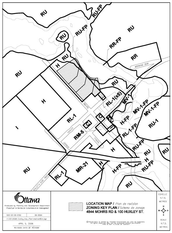
to Special Low Density Residential Zone (RL-1), as shown on Document 1 and as
detailed in Document 2.
RECOMMANDATION DU RAPPORT
Que le Comité de
l’urbanisme et de l’environnement recommande au Conseil d’approuver une
modification au Règlement de zonage de l’ancien Canton de West Carleton en vue
de changer le zonage d’une partie du 4844, chemin Mohrs. Les désignations
Aménagement différé (H), Rural (RU) et Rural avec des restrictions relatives à
la plaine inondable (RU-FP) seront remplacées par une Zone résidentielle
spéciale de faible densité (RL-1) et (RL-1-FP), et les dispositions relatives à
la Zone d’aménagement différé seront supprimées. Le zonage du 100, rue Huxley
qui désigne une Zone résidentielle spéciale de faible densité (RL-1(x5)) sera
remplacé par une Zone résidentielle spéciale de faible densité (RL-1), comme il
est illustré au Document 1 et précisé au Document 2.
BACKGROUND
The
Committee of Adjustment approved the subject area for three severances and a
lot line adjustment on March 23, 2006. The assigned municipal addresses of the
proposed parcels to be created are 4844, 4856, and 4868 Mohrs Road with the lot
line adjustment to the benefit of 100 Huxley Street.
The site is
located on the east side of Mohrs Road and to the north of Galetta Side Road in
the Village of Galetta. The
entire site is approximately 2.7 hectares in area with 202 metres of frontage
along Mohrs Road. The subject lands are vacant and undeveloped with trees and
bushes scattered throughout the site, with the exception of the former St.
Augustine’s Church, which has been converted to a single detached residential
home, located at 100 Huxley Street. The lot frontages of the four parcels range
from 44 to 95 metres and from 0.42 to 0.99 hectares in area.
In the surrounding area are single-detached homes to the west and south. The Mississippi River is located behind the properties.
DISCUSSION
City Council Approved Official Plan
In the City Council Approved Official Plan, the
site is designated as Village on
Schedule A, Rural Policy Plan. Development of villages traditionally occurred
on smaller lots serviced by private wells and septic system. Smaller villages
are intended to grow at modest levels while ensuring they remain distinctly
rural in character and scale. On Schedule K, Environmental Constraints, the rear of the site is
designated Flood Plain with unstable slopes. The site is designated as Residential in the Village Plan of Galetta on
Schedule F in Volume 2C of the City Council Approved Official Plan.
Former Regional Official Plan
In the former Regional Official Plan, the site
is designated as Village and River Corridor. The intent of the Village
designation is to provide housing for rural families and retired farmers who
wish to remain in the area as well as for others who desire an opportunity to
live in a community of a size and character which is distinctly different from
an urban or suburban neighbourhood. For properties that are within the Marginal
Resource River Corridor, limited non-farm residential development is intended.
Former Township of West Carleton Official Plan
In the former Township of West Carleton
Official Plan, the site is designated as Village - Residential and Hazard Lands
(unstable slopes). The predominant use of land within Villages is
single-family, duplex, or semi-detached residential dwellings. Owners and
developers are to provide plans for new developments to ensure soil conditions
are suitable for the proposed development. Construction on existing lots should
only occur on portions outside of the Hazard Land designation or on land which
further study proves is not actually subject to the hazardous conditions.
Proposed Zoning By-law Amendment
The majority of the site is designated as Holding
Zone (H). A small portion to the rear
of the properties are zoned Rural (RU) and the rear edge of the site which runs
along the Mississippi River is zoned Rural – Flood Plain (RU-FP). 100 Huxley
Street is zoned as a Special Low Density Residential Zone (RL-1(x5)). The
applicant proposes to rezone the property currently zoned H, RU, and RL-1(x5)
to RL-1, which is the same zoning of the immediate residential areas to the
west and south. The RU-FP area is proposed to be rezoned to RL-1-FP. The
Holding Zone provisions are to be removed.
100 Huxley Street is zoned as RL-1(x5) which
limits the lot area and frontage to the existing conditions and the number of
bedrooms to two. As the property at 100 Huxley Street has been expanded from
the lot line adjustment, a rezoning is necessary to reflect the increased lot
size and frontage, as well as, to regularize the zoning of the entire lot. An
increase in total bedrooms is only required to have a modified Certificate of
Approval from the Ottawa Septic Approvals Office (RVCA) and does not require subsequent
modification to the Zoning By-law.
The proposed zoning to RL-1 is in keeping of
the zoning in the immediate area. Each parcel meets the minimum lot frontage
and area zoning provisions in the RL-1 Zone. The flood plain area will remain
to be in a flood plain zone, except within RL-1-FP, in order to regularize the
zoning of the lots to low-density residential.
The Mississippi Conservation Authority
initially requested a geotechnical study due to the steep slopes and old pit
located within the proposed lot, which will be known as 4868 Mohrs Road. After
a site visit with the applicant on January 13th, the Conservation
Authority was satisfied that there is an adequate building envelope and no
longer required the geotechnical study at this time. Staff noted that due to
the proximity of the Mississippi River, the applicant should be aware of
possible slope stability and flood plain problems, which may need to be
addressed before a building permit is issued. Accesses, grading, and culverts
for the new lots will be dealt with through the appropriate permits when a
building permit application is submitted.
The Zoning By-law amendment
satisfies the intent of the current H - Holding Zone provisions as implemented
by the former Township of West Carleton to protect for residential uses subject
to specific information being provided as to how these lots are to be
developed. The Holding Zone provisions have now been satisfied and can now be
removed. These lands are designated in the City Council Approved Official Plan
and the former Township of West Carleton Official Plan to permit residential
development. The proposal also conforms to the Village policies in the City
Council Approved Official Plan and former Regional Official Plan as the
proposed rezoning is consistent with the surrounding area and existing rural
character.
Heritage Considerations
The building located at 100 Huxley
Street, the former St. Augustine Church that was converted to a single detached
home, is designated under Part 4 of the Heritage Act. Any future additions
proposed to the structure will require approvals under the Heritage Act and
would be reviewed by the City's LACAC Committee.
Servicing Issues
The Ottawa Septic System Office does
not have concerns regarding the lot sizes. The Committee of Adjustment have
imposed a condition such that each lot have sufficient drinking water meeting
the Ministry of Environment's "Ontario Drinking Water Objective"
prior to final consent of the severances.
ENVIRONMENTAL
IMPLICATIONS
The Mississippi Conservation Authority have classified the back cliffs next to the Mississippi River as an eroded channel. Building setbacks of a minimum of 30 metres will be required from the edge. The rear of the properties is within the 100-year flood plain and only an accessory use to a main residential use, which is located outside of the flood plain, is permitted.
RURAL IMPLICATIONS
The rezoning from H, RU, RU-FP, and RL-1(x5) to RL-1 and RL-1-FP conforms to the Village policies for residential development and is consistent with the zoning in the surrounding area.
CONSULTATION
Notice of this application was
carried out in accordance with the City’s Public Notification and Consultation
Policy. The Ward Councillor is aware of
this application and the staff recommendation.
The City did not receive any negative comments or opposition to this
application.
FINANCIAL IMPLICATIONS
APPLICATION PROCESS
TIMELINE STATUS
The application was not processed by the
"On-Time Decision Date" established for the processing of Zoning
By-Law amendments due to the post-ponement of the Committee of Adjustment
meeting regarding the severances from January 10 to March 13.
SUPPORTING DOCUMENTATION
Document 1 Location Map
Document 2 Details
of Recommended Zoning
DISPOSITION
Corporate Services Department, City
Clerk's Branch to notify the owner (Margaret Pocket, 100 Huxley Street, RR
#1, Arnprior, ON K7S 3G7), applicant (James Jack, 158 John Street North,
Arnprior, ON K7S 2N7), Signs.ca, 866 Campbell Avenue, Ottawa, ON K2A 2C5, and Ghislain Lamarche, Program
Manager, Assessment, Financial Services Branch (Mail Code: 26-76) of
City Council's decision.
Planning and Growth Management Department to
prepare the implementing by-law, forward to Legal Services Branch and undertake
the statutory notification.
Corporate Services Department, Legal Services
Branch to forward the implementing by-law to City Council.
DOCUMENT 1
LOCATION MAP
DOCUMENT 2
DETAILS OF RECOMMENDED ZONING
That
Schedule A, Map 4 of By-law No. 42-93 be amended to change the existing zoning
of part of 4844 Mohrs Road as follows:
(a) from Holding Zone (H) and Rural (RU) to a Special Low Density Residential Zone (RL-1);
(b) from Rural with Flood Plain Regulations (RU-FP) to a Special Low Density Residential Zone with Flood Plain Regulations (RL-1-FP).
That Schedule A, Map 4 of By-law 42-93 be amended to change the existing zoning of 100 Huxley Street from Special Low Density Residential (RL-1(x5)) to Special Low Density Residential Zone (RL-1).