2. DEFERRAL OF COMMUNITY DESIGN PLAN FOR DUNROBIN
VILLAGE
REPORT DU PLAN DE
CONCEPTION COMMUNAUTAIRE DU VILLAGE DE DUNROBIN
|
COMMITTEE
RECOMMENDATION
That Council set aside the requirement for the Planning
and Growth Management Department to complete a Community Design Plan (CDP) for
the Village of Dunrobin and reconsider the need for a CDP at a future date.
Recommandation du comitÉ
Que le Conseil
municipale mettent de côté la demande faite à Urbanisme et Gestion de la
croissance d’élaborer un Plan de conception communautaire (PCC) pour le Village
de Dunrobin et d’examiner à nouveau la nécessité d’un PCC à une date
ultérieure.
Documentation
1.
Deputy
City Manager, Planning and Growth
Management report dated 11 April 2006 (ACS2006-PGM-POL-0039).
2. Extract of Draft Minutes 26,
Agriculture and Rural Affairs Committee meeting of May 11, 2006.
Report to/Rapport au :
Agriculture and Rural
Affairs Committee
Comité de l'agriculture et des questions rurales
and Council / et au Conseil
11 April 2006 / le 11 avril 2006
Submitted by/Soumis par : Ned Lathrop,
Deputy City Manager/Directeur municipal adjoint,
Planning and Growth Management/Urbanisme et Gestion de la croissance
Contact
Person/Personne ressource : Richard Kilstrom, Manager / Gestionnaire
Planning, Environment and Infrastructure
Policy/
Politiques d’urbanisme, d’environnement et
d’infrastructure
(613) 580-2424 x22635,
Richard.Kilstrom@ottawa.ca
|
|
Ref
N°:
ACS2006-PGM-POL-0039
|
|
SUBJECT:
|
DEFERRAL OF COMMUNITY DESIGN PLAN FOR DUNROBIN VILLAGE
|
|
|
|
|
OBJET :
|
REPORT DU PLAN DE CONCEPTION COMMUNAUTAIRE DU VILLAGE DE DUNROBIN
|
REPORT RECOMMENDATION
That the Agriculture and Rural
Affairs Committee recommend City Council set aside the requirement for the
Planning and Growth Management Department to complete a Community Design Plan
(CDP) for the Village of Dunrobin and reconsider the need for a CDP at a future
date.
RECOMMANDATION DU RAPPORT
Que le Comité de l'agriculture et
des questions rurales recommande au Conseil de mettre de côté la
demande faite à Urbanisme et Gestion de la croissance d’élaborer un Plan de
conception communautaire (PCC) pour le Village de Dunrobin et d’examiner à
nouveau la nécessité d’un PCC à une date ultérieure.
BACKGROUND
The Village of Dunrobin
is located on the north side of the Thomas Dolan Parkway at the intersection
with Dunrobin Road. The village is
within the former Township of West Carleton, at the boundary of the former City
of Kanata.
Expansion of the village to the
south, into the former City of Kanata, has been at issue periodically. The City of Kanata had designated an area in
the southwest quadrant of the intersection as Village, but later asked the
former Region of Ottawa-Carleton to not designate any land within the municipality
for Village development in the 1997 Regional Official Plan. The 2003 Official Plan continued with this
designation, with the Village only occupying lands north of Thomas Dolan
Parkway in the former Township of West Carleton.
At amalgamation in 2001 and later
during the public meetings on the 2003 Official Plan, the City received several
representations regarding the location of the Village boundary. Council refused an application by FKZ
Investments to expand the village to the north and considered representations
from a landowner to the south. During
the public meetings on the Official Plan, Council directed staff to undertake a
community design plan for the Village of Dunrobin, on the advice of staff that
this was the best approach to consider any change in the village boundary.
Following Council’s adoption of
the Official Plan, appeals of the Village boundary were filed on behalf of
Charles Delahunt and Milford Holdings/Blue Heron Storage, both landowners in
the southeast quadrant of Thomas Dolan Parkway and Dunrobin Road.
The purpose of this report is to
update Council on work undertaken within the area and request that completion
of a community design plan for the village be deferred.
DISCUSSION
Water quality has been a
long-standing issue in the Dunrobin area.
Within the village, housing is developed on private wells and septic
systems and hydrogeological studies are used to determine the size of lot that
can be developed. Over the years,
several hydrogeological studies and surveys have been completed for specific
subdivisions and as well as overviews for the larger area, including the
Dunrobin Private Services by Geo-analysis Inc., for the City of Kanata.
Staff contracted with Golder
Associates Ltd. to review and synthesize previous studies related to ground and
surface water conditions in the village and surrounding area. Such a review would be the initial step in a
community design plan, since any expansion of the village would be based on private
services. Golder Associates found in general that hard groundwater with
elevated iron and manganese concentrations is common. Colour, total dissolved solids, and sodium concentrations are
also commonly elevated. On-site
treatment is common, although in some cases the treatment process has led to
red iron precipitate in drainage ditches and ponded water adjacent to
residential areas. On the whole, the
study concluded that the area was not suitable for further expansion of village
size lots.
The parties who had appealed the
village boundary were also consulted during this process. After the initial overview was complete, the
City contracted Golders to prepare a terms of reference for a hydrogeological
assessment for the subject sites, which was completed by one of the landowners
in January 2006. Golders reviewed the
study for the City, and concluded it did not fulfil the terms of reference set
for the work and did not provide sufficient support for development on private
servicing on the subject lands. A
hearing on the appeals on behalf of Delahunt and Milford Holdings/Blue Heron is
scheduled for July 4, 2006.
CONCLUSION
Staff propose that on the basis
of the work completed to date, that the community design plan for Dunrobin be
deferred and later consider such matters as village character and development
of the remaining vacant lands within the boundary. There is no need for additional lots in the western, rural area
of the city now. Villages such as Carp
(400 lot potential), Constance Bay (60 lot potential) and Fitzroy Harbour (50 lot
potential) together have potential for about 500 additional village lots, while
400 lots are in draft- approved country lot subdivisions and another 400 lots
are in proposed subdivisions in the former Kanata and West Carleton, according
to the City’s Rural Residential Vacant Land Survey, May 2005.
CONSULTATION
The Planning and Growth Management Department has
notified the appellants to the 2003 Official Plan Village of Dunrobin Boundary
of this report and the Committee and Council dates that it will be considered.
FINANCIAL IMPLICATIONS
The report has no financial
implications.
SUPPORTING DOCUMENTATION
Document 1 Location Plan
DISPOSITION
Planning and Growth
Management Department to notify appellants of Council Decision.
LOCATION PLAN DOCUMENT
1

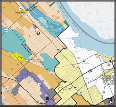
Extract From Official Plan –
Schedule A, Rural Policy Plan
DEFERRAL
OF COMMUNITY DESIGN PLAN FOR DUNROBIN VILLAGE
REPORT DU PLAN DE
CONCEPTION COMMUNAUTAIRE DU VILLAGE DE DUNROBIN
ACS2006-PGM-POL-0039
Mr. S. Sayah,
Planner, Planning & Growth Management, provided a presentation in which: he
discussed the background of this matter; he talked about water quality issues
in the Dunrobin area; and he outlined staff’s recommendation with respect to
the preparation of a community design plan for Dunrobin Village. A copy of his presentation is held on file.
Dr. B.
Firestone indicated he would be discussing 2 issues: the community design plan, which had been
promised for Dunrobin Village for some years; and the village boundary. He noted that the two issues were no longer
connected and that the Committee could expand the village boundary if it chose
to do so. He stated the purpose of his
presentation was to ask for the re-instatement of the village boundary, which would
allow him and Mr. T. Savasta to create 14 new 1-acre lots on their
properties. Dr. Firestone then provided
a presentation in which he talked about the history and character of Dunrobin
Village. A copy of his presentation is
held on file.
Following his
presentation, Dr. Firestone provided the following documents, which are held on
file with the City Clerk:
•
Letter from Councillor Eli El-Chantiry to the Ontario
Municipal Board dated September 20, 2004
•
Letter from Dwight Eastman to the Ontario Municipal Board and
Board of Negotiation dated September 2, 2004
•
“Dunrobin Village, History and Development – A Rationale for
Inclusion as a Designated Village in the City of Ottawa’s New Official Plan”,
Copyright June, 2001, Dr. Bruce M. Firestone and Mr. Tim Chadder
•
Letter from Joshua Moon to the Ministry of Municipal Affairs
and Housing dated December 8, 2003
•
Facsimile transmittal from Dr. Bruce M. Firestone to Mr. Tim
Marc dated October 28, 2004
•
Memo from Mr. Tony Savasta to Mr. Tim Marc, Ms. Lesley
Paterson and Mr. Roddy Bolivar dated January 13, 2005
•
Letter from Mr. Tony Savasta to Mr. Tim Marc dated October 28,
2004
•
Letter from Dr. Andrzej Olender to the Ontario Municipal Board
and Board of Negotiation dated April 25, 2006
•
Letter from Mr. Peter J.A. Stanton of Stanton Drilling Inc. to
Mr. Jeff Ostafichuk dated July 29, 1999
•
Letter from Peter J.A. Stanton to Mr. Tony Savasta dated May
9, 2006
•
Letter from C.R. Morey to Mr. T. Savasta and Mr. B. Firestone
dated May 10, 2006
Councillor
El-Chantiry felt there was an issue with respect to the water in Dunrobin. He referenced the speaker’s comments and
staff’s position and he noted that Committee was receiving conflicting
information. Therefore, he requested
clarification. Dr. Firestone indicated
he knew more than half the residents in Dunrobin and he believed there was
tremendous support for continuing to build on to the community. He submitted that there had been some
over-depth wells dug by one unscrupulous well driller in the area but that
where his company had drilled the well, all had met the standards set by the
Ministry of the Environment (MOE). He
reported that when the Dunrobin Lakes subdivision was developed, the MOE
approved each well record and acutest well results and the Mayor of the former
Township of West Carleton signed-off on the one-foot reserve before any lots
were conveyed to purchasers. He
maintained that this protected the purchaser and it put the onus on the
developer to produce good water.
When asked to
comment from staff’s perspective, Mr. Sayah provided background information
dating back to 1990 with respect to water quality issues in Dunrobin. He advised that at that time, the Mayor of
West Carleton wrote a letter to the MOE asking them to not approve a
subdivision in Dunrobin because of water quality concerns and he referenced
documentation that suggested the Township had reluctantly accepted water
quality conditions for plans of subdivisions.
He noted that in 1992, the former City of Kanata commissioned a study
with respect to ground water quality to specifically look at a Dunrobin village
expansion towards the Kanata boundary.
That study concluded more work had to be done and the former City of
Kanata asked the former Region to change its boundary in the 1997 Regional
Official Plan.
Mr. Sayah
maintained that, based on evidence with respect to water quality in Dunrobin
and based on other development priorities, staff did not see any pressing need
to expand the boundary or to consider a CDP at this time. With respect to the water quality
objectives, he reported that staff had asked Dr. Firestone and Mr. Savasta to
conduct a hydro-geological investigation of the lands. The department commissioned Golders and
Associates to create a terms of reference and based on these terms of reference,
the land owners were asked to dig 3 test wells across the site (Mr. Savasta’s
and Dr. Firestone’s properties, which they proposed to develop). The land owners dug one test well on the
site and provided water samples from other wells in the vicinity of the subject
property. Mr. Sayah indicated one of
the wells, for which samples were provided, had levels of iron well over the
MOE treatability limits. He also noted
that sodium concentrations were relatively high. Although there could be some test results within the MOE
treatability limits, based on the results that were above the treatability
limits, staff did not feel it would be responsible to expand the boundary. He submitted that the City should focus its
growth in areas where there are lots available and the water quality is
better.
Responding to
further questions from Chair Jellett and Councillor El-Chantiry, Mr. D. Jacobs,
Director of Planning, Environment & Infrastructure Policy, acknowledged
that the condition being proposed by Dr. Firestone would, to some extent, deal
with the water quality concern.
However, he maintained that the City had to look beyond the water
issue. He submitted that if, some time in
the future, several lots in a row were found to not meet the standard and therefore
could not be developed, the City would have be in a position of having to
provide services into an area that could not be fully developed. Therefore, although Dr. Firestone’s caveat
may protect potential purchasers, it would not protect the City with respect to
providing services or extending services into the area. He indicated the experience has been that,
in areas requiring on-site treatment, the level of complaints tended to be
significant and, the more people complained, the more pressure there was to
provide other municipal services.
Therefore, he did not feel he could recommend developing into an area
that had questionable water quality.
Chair
Jellett inquired as to the costs and implications of on-site treatment. Dr. Firestone indicated this referred to
water softeners, which cost between $700 to $2,000.
Chair
Jellett wondered if, as a developer, Dr. Firestone would be opposed to adding a
second condition; in addition to having an MOE-approved well, that each lot
contain the proper filter. Dr.
Firestone responded affirmatively and noted that, in a letter dated September
2, 2004, the former Mayor of West Carleton, Mr. D. Eastman, had expressed his
support for the village expansion.
Responding to earlier comments with respect to test wells, he advised
that he and Mr. Savasta had provided almost 38 different well records and tests
and that the City and its consultant focused on the few that were
sub-standard.
Mr.
T. Savasta talked about the health and vibrancy of the subdivisions already
in existence in Dunrobin, noting he had resided in the area for the past 30
years. He indicated the well that had
tested high in iron and sodium was actually located in the old subdivision, on
the property of a family he knew well; a family that had lived there for 8
years and had 3 fine young kids. He
referenced the water conditioning systems available to treat ground water and
he submitted that water was not an issue.
He re-iterated Dr. Firestone’s last comment with respect to the City
focusing on one or two instances where water tests had not met the
standards. He maintained that the wells
on the subject property were well within MOE guidelines.
Councillor
El-Chantiry requested clarification on Dr. Firestone’s position with respect to
deferral of the Community Design Plan for Dunrobin. Dr. Firestone indicated he hoped Committee and Council would
assist the village by expanding the boundary.
He believed that would give the village breathing room and time for the
City to organize itself to do a community design plan. Although he felt a community design plan
would be important, he was not opposed to deferring it for 2 or 3 years.
Councillor
Brooks maintained that water was always an issue; whether quantity or
quality. He noted that the property owners
had been asked to drill 3 test wells on the subject property and he wondered,
other than costs, why they had not done so.
Mr. Savasta indicated they had drilled one test well on the subject
property, they had taken a sample from an existing well on an adjacent property
(at the Blue Heron warehouse site) and they used sample wells on the North
side. He submitted they felt that would
give a broad perspective.
Mr.
Jacobs responded to a series of questions from Committee members with respect
to the department’s current CPD workload, whether the deferral of the Dunrobin
CDP would free up resources for other projects and the cost of conducting a
CDP. He advised that with the current
CDP workload, the department was working with less staff than was required. He could not provide a specific dollar value
for conducting a CDP because each one was different, depending on its scope and
depending on whether or not it could be done entirely with internal resources.
Responding
to questions with respect to the deferral, Mr. Jacobs indicated there was no
timetable attached to the project. He
submitted that Committee could provide direction, which staff would use to
produce the department’s work program for subsequent years.
Chair Jellett
directed staff to bring the matter back to Committee for further discussion in
2 years.
That the Agriculture and Rural Affairs
Committee recommend City Council set aside the requirement for the Planning and
Growth Management Department to complete a Community Design Plan (CDP) for the
Village of Dunrobin and reconsider the need for a CDP at a future date.
CARRIED