Report
to/Rapport au :
Planning and Environment Committee
Comité de l'urbanisme et de
l'environnement
and Council / et au Conseil
Submitted by/Soumis par : Ned Lathrop, Deputy City Manager/
Directeur municipal adjointe,
Planning and Growth Management / Urbansime et Gestion de la croissance
Contact Person/Personne ressource : Karen Currie,
Manager / Gestionnaire
Development Approvals / Approbation des
demandes d'aménagement
(613) 580-2424 x28310,
Karen.Currie@ottawa.ca
|
SUBJECT: |
|
|
|
|
|
OBJET : |
Plan de
conception communautaire Mer bleue |
REPORT RECOMMENDATION
That the Planning and Environment Committee recommend that Council approve the Mer Bleue Community Design Plan as detailed in Document 7 (under separate cover).
RECOMMANDATION DU RAPPORT
Que le
Comité de l'urbanisme et de l'environnement recommande que le Conseil approuve
le Plan de conception communautaire Mer Bleue, tel que détaillé dans le
document 7 (disponible séparément).
EXECUTIVE SUMMARY
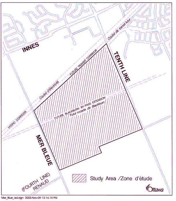
On September 14, 2005, Council adopted Official Plan Amendment 35, which redesignated lands in the south-east portion of Orléans from Employment Area to General Urban Area and Mixed Use Centre. As a condition of approval, Council required City staff to work with the landowners to prepare a Community Design Plan (CDP) for the area east of Mer Bleue Road, west of Tenth Line Road, south of the Hydro corridor and north of urban boundary in order to establish a land use framework that reflects the principles, objectives and policies of the Official Plan and guide development applications within these lands. This future development area is approximately 160 hectares in size.
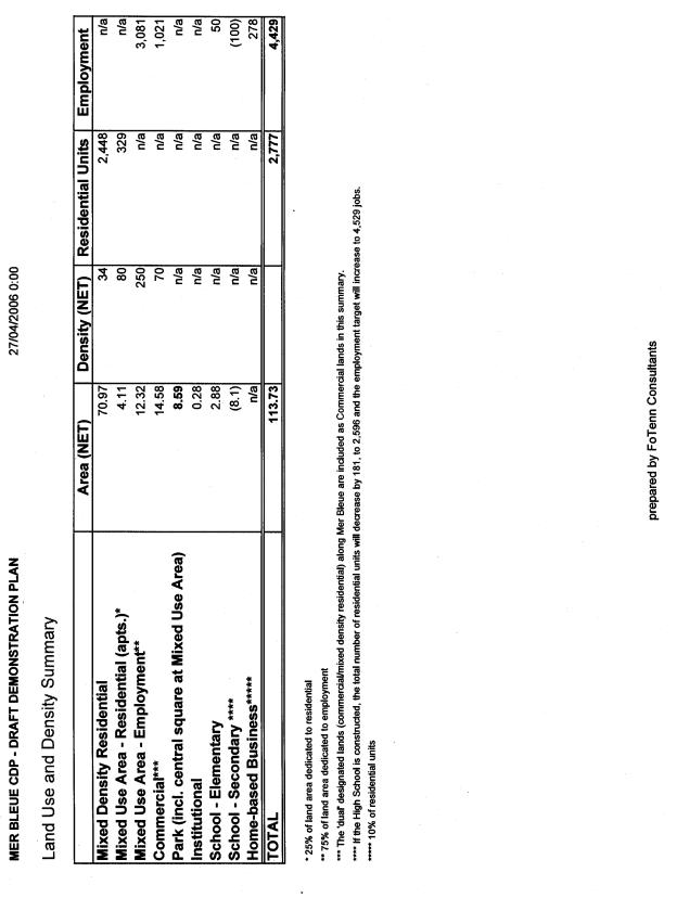
The CDP establishes the arrangement of the public road network, the location of residential, commercial and institutional uses, as well as the location of parks and open spaces for the study area. It also serves as a community development guideline document for the preparation and review of development applications within these lands. The CDP proposes an estimated 3000 residential units and a range of 4000-5000 jobs.
The second public open house meeting was held in the community on March 22, 2006. The purpose of this meeting was to display for public review and comment a draft of the preferred CDP alternative, a demonstration plan showing how the community could be developed as well as the various background studies updated and prepared in support of the CDP.
In addition to the above-noted meetings, various meetings were held throughout the process with the Conservation Authority, other City Departments, landowners and adjacent residents.
RÉSUMÉ
Hypothèses et analyse :
Le 14 septembre 2005, le Conseil a adopté la
modification n° 35 du Plan officiel qui a permis de modifier la désignation de
terrains situés dans la partie sud-est d'Orléans, les faisant passer de secteur
d'emploi à zone urbaine générale et centre polyvalent. Comme condition
nécessaire à l'approbation, le Conseil a demandé à ce que le personnel de la
Ville travaille avec les propriétaires fonciers à la préparation d'un Plan de
conception communautaire (PCC) pour le secteur situé à l'est du chemin Mer
Bleue, à l'ouest du chemin Tenth Line, au sud du couloir de transport de
l'électricité et au nord de la limite urbaine afin d'établir un cadre
d'utilisation des terrains qui tient compte des principes, des objectifs et des
politiques du Plan officiel et qui guide les demandes d'aménagement sur ces
terrains. Cette future zone d’aménagement représente une superficie d'environ 160
hectares.
Le PCC établit la configuration du réseau
public routier, l'emplacement des utilisations résidentielles, commerciales et
institutionnelles ainsi que l'emplacement des parcs et des aires ouvertes pour
le secteur à l'étude. Il sert aussi de lignes directrices en matière
d'aménagement communautaire pour la préparation et l'examen des demandes
d'aménagement pour ces terrains. Le PCC prévoit environ 3 000 unités
d'habitation et entre 4 000 et 5 000 emplois.
Répercussions financières :
Consultation publique :
La deuxième séance portes ouvertes a eu lieu
dans la communauté le 22 mars 2006. Cette séance avait pour but de présenter à
la population une version préliminaire de l'alternative du PCC préférée afin
qu'elle puisse l’étudier et la commenter, un plan de démonstration présentant
les façons dont la communauté pourrait être développée ainsi que les diverses
études préliminaires mises à jour et préparées pour appuyer le PCC.
En plus
des séances précitées, différentes réunions ont été tenues tout au long du
processus avec l'office de protection de la nature, d'autres services de la
Ville, des propriétaires et des résidents adjacents.
BACKGROUND
On September 14, 2005, Council adopted Official Plan Amendment 35, which redesignated 160 hectares of land in the south part of Orléans. The lands in question are located south of the Hydro Corridor, east of Mer Bleue Road, west of Tenth Line Road and north of the urban boundary (see Document 1). The Amendment redesignated the lands from Employment Area to General Urban Area and Mixed Use Centre. As a condition of approval, Council required City staff to work with the landowners to prepare a Community Design Plan (CDP) to establish a land use framework to guide the future development within this new community. The purpose of the CDP is to provide a comprehensive vision and a conceptual framework which reflects the principles, objectives and policies of the Official Plan that will guide the preparation and review of development applications within these lands.
The study area known to this point as Neighbourhood 5, is bisected by the future extension of the Blackburn Hamlet Bypass and includes stations for the transit line just south of the Hydro corridor at Mer Bleue Road and Tenth Line Road. To the north of the study area is the eastern portion of the Orléans Industrial Park for which a Land Use and Design Study was recently completed. The area west of Mer Bleue Road is also subject to a Community Design Plan for a residential neighbourhood. Phase 1 of this plan was completed in June, 2005 and Phase 2 is currently under review. A municipal snow disposal facility is planned north-west of the site along Mer Bleue Road just north of the Hydro Corridor.
The Mer Bleue Community Design Plan was initiated by the City and was developed with the support of consultants retained by the landowners. The CDP was guided by a project team consisting of landowners, engineering and planning consultants led by City staff and involving input from the public, surrounding landowners, internal City departments, school boards and outside technical agencies. The study process included detailed geotechnical, servicing and traffic analysis.
The plan envisions the development of a mixed-use community with approximately 3000 residential units and a range of 4000-5000 jobs. The density targets associated with the "Developing Community" Official Plan land use designation apply to the lands designated "General Urban". A range of housing types is provided including a maximum of 60% single detached and semi-detached, at least 10% apartment dwellings and the remainder multiple dwellings other than apartments.
DISCUSSION
The Mer Bleue CDP indicates how the housing mix, residential density, parks and green space objectives in the new Official Plan (OP) can be met and illustrates the arrangement of all types of land uses, including commercial, open spaces and transportation corridors. The CDP will serve as a community development guideline document, which incorporates and provides detail on the policy direction for design in the new Official Plan. The Mixed Use Centre will be subject to an Official Plan Amendment and a more detailed analysis to determine how the plan will be implemented in this area.
In addition, the CDP considers the proposed and existing development areas adjacent to the study area, establishes the collector road network and identifies key land use, density and infrastructure assumptions for the lands within the study area.
An Existing Conditions Report dated January 18, 2006 was prepared to give general information on the study area. A summary of its findings form Document 2.
COMMUNITY DESIGN PLAN
The Mer Bleue CDP has been guided by the direction and policies in the Official Plan, including Section 2.5.7 "Collaborative Community Building and Community Design Plans" and Section 3.6.4. "Developing Community". In addition, the proposed plan was influenced by existing and proposed road and transit networks, the future Mixed Use Centre (MUC), the natural environment features, the proposed snow disposal facility and the servicing studies for the area.
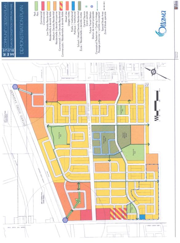
Neighbourhood 5 is structured with a modified grid road network, proposed commercial blocks, a mixed use centre and new parks. The homes in the neighbourhood are within a 400 metre radius of neighbourhood and community parks. On and off-street pedestrian and cycling networks will be provided throughout the development which will create a link to adjacent communities and transit.
A minimum employment target of 4000-5000 jobs formed part of the Official Plan Amendment for these lands. To ensure this target is met, sufficient land will have to be set aside for employment. It is anticipated that the Mixed Use areas near the transit stations will generate over 2500 jobs, the commercial designations will generate 1200 jobs and the balance is expected in institutional uses, schools and home based businesses throughout the study area.
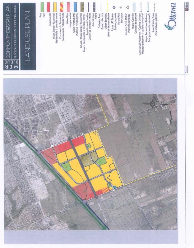
Six land use designations will apply to the lands within the Mer Bleue Community Design Plan: Mixed Density Residential, Mixed Use Areas, Commercial, Schools, Other Institutional Uses and Parks. Document 3 illustrates the distribution of land uses.
Mixed Density Residential
This community will provide a variety of housing forms, mixed throughout the community. The overall residential density will be at least 29 units per net hectare, with higher density residential uses located close to the Mixed Use areas and in areas of constrained soils. Mixed Density Residential can include singles, semi-detached, townhomes, stacked townhomes and low-rise apartments (maximum of 6 storeys). In accordance with OP policies for developing communities, the plan will provide a maximum of 60% single detached and semi-detached, at least 10% apartment dwellings and the remainder multiple dwellings other than apartments.
Mixed Use Areas
The Mixed Use areas located at the north-west and north-east corners of the lands in proximity to the transit stations, will accommodate a wide range of office, institutional, and convenience retail uses, with the objective of becoming high-density employment-generating nodes for the area. The Official Plan policies state that lands within 400 metres of Transit Stations are intended to develop as compact, mixed-use, pedestrian friendly cores. The plan will direct built form to the proposed transit stations at Mer Bleue Road and Tenth Line Road and encourage pedestrian access to transit. High density residential uses will be integrated with non-residential uses in the same building. Approximately 300 high density residential units will be provided. Non-residential uses can include institutional, commercial and service uses such as professional and medical offices, retail stores, restaurants, service commercial, financial institutions, hotels, entertainment and recreational uses. These uses should support job creation at a rate of one employee for every 30 square metres of floor area in order to achieve the employment targets of the plan. The two mixed-use areas are expected to generate over 2500 jobs.
Commercial
Commercial nodes are located along Mer Bleue Road and Tenth Line Road at the intersections with the Blackburn Hamlet Bypass Extension. The intent of this designation is to provide commercial uses such as food services, neighbourhood serving retail, financial services, gymnasiums and child care.
Institutional Uses
A Public / Institutional block has been reserved along Mer Bleue Road at the intersection of the east-west collector road south of the Blackburn Hamlet Bypass Extension. Public land uses such as libraries, schools, fire stations or municipal servicing facilities are appropriate for this designation. Institutions such as churches and private schools are also suitable for this area. It is recognized that this block may be re-located in the future, as its specific use is determined. Inclusion in the plan at this time is important to recognize the possibility of such a use.
Parks
Two large Community Parks, approximately 3.25 hectares in size, are centrally located along collector roads and are focal points for the north and south sectors of the plan. They will accommodate sports fields such as soccer as well as a variety of other recreational activities, active and passive. The two 0.8 hectare Neighbourhood Parks are both located in the south half of the plan and will provide small-scale recreational uses and passive recreation.
The Hydro corridor which is designated in the OP as a Major Recreational Pathway and Cycling Route, will connect the area to the City's pathway and cycling network.
The total parkland required based on 2700 residential units provided on the land use plan is approximately 9.0 hectares. The demonstration plan indicates a total of 8.1 hectares of parkland, plus the public square located in the Mixed Use Centre. Cash-in-lieu of parkland will also be collected in accordance with Planning Act requirements for commercial uses.
Schools
Two school sites have been provided on the plan and are centrally located in the southern sector. The Ottawa-Carleton District School Board have requested that a 2.8 hectare site be reserved for a future Elementary School. A 8.0 hectare site has been shown at the request of The Ottawa-Carleton Catholic School Board for a future Secondary School.
The Elementary School site is located adjacent to a Community Park which provides the opportunity for shared parking and facilities between the City and the school board.
These sites will have dual zoning to permit medium density residential uses as an alternative use in the event that the sites are not acquired by the school boards within the prescribed time limit.
Special Study Area
The CDP identifies a Special Study Area which corresponds to the limit of the fill and floodplain mapping for McKinnons Creek regulated by the South Nation Conservation Authority at the south-western corner of the lands. The Provincial Policy Statement allows development and site alteration in hazardous zones other than floodways, provided the hazard can be safely addressed. Because the construction of buildings and placing of fill in the floodplains may reduce the natural storage area of a stream, a process to amend the floodplain mapping has been undertaken to allow development. This modification is currently in progress and must be completed to the satisfaction of the South Nation Conservation Authority prior to the approval of any planning applications in this area. In the interim, the lands will be zoned with a holding provision prohibiting development.
Pedestrian Network
Sidewalks and pathway connections make up the pedestrian network throughout Neighbourhood 5. Some of the local roads will have a sidewalk on one side, whereas the collectors and arterials will provide a sidewalk on both sides of the road. Pathway connections will provide additional links between roads, community facilities, schools, parks and commercial uses.
Transportation Plan
A Transportation Impact Study has been prepared in support of the Community Design Plan. The transportation network is composed of a system of interconnected collectors and local roads organized in a modified grid system to permit accessibility and flexibility of movement. The network provides connectivity to the future transit stations at Mer Bleue and Tenth Line Roads, while concentrating larger volumes of traffic to key intersections, avoiding traffic through the local residential portions of the neighbourhood.
The Transportation Impact Study anticipated the generation of more than 4000 jobs and 2700 residential units of varying densities and examined traffic growth, traffic generated by the community, traffic distribution and traffic impact. Based on the findings of the study, there is sufficient capacity provided on the road network to accommodate projected internal and external traffic volumes.
Transit Service
All major collectors within the development area will be designed to accommodate buses. The internal road system will be connected to the major arterials Mer Bleue Road, Tenth Line Road and the Blackburn Hamlet Bypass in order to facilitate routing of buses throughout the community and connections to the future transit stations which will be located on Mer Bleue Road and Tenth Line Road. Separation distance between local bus stops along collector roads should be no more than 200 to 250 metres and walking distance to bus stops is not to exceed 400 metres.
Servicing Plan
The Municipal Servicing Plan for the Mer Bleue CDP has been developed respecting the location of major existing and proposed new infrastructure within and around this community. The plan protects major servicing corridors for trunk water, wastewater and stormwater infrastructure to allow for a cost effective phased development of the entire neighbourhood.
The water distribution system for the CDP area has been studied to include watermain connections in Neighbourhood 5 with internal looping providing a strong overall system which will facilitate staged development over several years.
The runoff from Neighbourhood 5 will be controlled in an off-line water quality/quantity stormwater management facility designed as an extended detention hybrid wet pond providing an enhanced level of protection. The pond will be located south of the study area and east of McKinnons’ Creek.
The proposed storm sewer system consists of an east west trunk sewer which runs along the southern boundary of Neighbourhood 5 and intercepts two north south storm trunk sewers which service the entire neighbourhood and conveys the flow to the stormwater management pond just south of the development area.
The sanitary sewer system which will service the area is designed in conjunction with the development of the proposed storm sewer system for Neighbourhood 5 but will outlet into the Tenth Line Road Pump Station.
Affordable Housing
Affordable Housing will be required in accordance with Section 2.5.2 of the Official Plan. The Official Plan directs that 25% of all new housing development and redevelopment is to be affordable to households at or below the 30th income percentile for rental and at or below the 40th income percentile for ownership. Within the CDP area, approximately 675 homes will be within the affordability range as determined at the time of subdivision development approval. In Neighbourhood 5 approximately 40% of the estimated 2700 housing units will be comprised of multiple-unit structures (10% apartments and 30% townhomes).
The development of "social housing" for low and moderate income households by social housing providers, with or without City funding or incentives, will be included within the total 25% of affordable housing in the community. No specific sites have been identified for this use at this time.
Design Guidelines
A set of Design Guidelines has been established which will apply to all development within the Mer Bleue CDP area. The CDP examines how open space, public infrastructure and built form can work together to structure neighbourhoods and contribute to community development. The community identity will rely solely on the location, architecture and design of new construction as well as landscaping. Guidelines have been created for gateways and prominent corners, noise attenuation, residential neighbourhoods, parks, schools, transit, commercial uses, institutional uses, mixed-use areas and streets.
Gateways and Prominent Corners
Gateways and Prominent street corners will be highlighted by special streetscape treatment such as low decorative masonry walls, distinct lighting and planting as well as building architecture. On corner lots, buildings will be oriented to face both street fronts. Such buildings are to be designed with a consistent architectural character to address both streets. Parking areas will be located away from gateway intersections. Treed entry boulevards and medians will be created to define the entrances into the neighbourhood.
Streets
In accordance with the Official Plan, streets within this community have been designed using a modified grid pattern to maximize the number of access and egress points, increase permeability of the network, increase pedestrian and transit accessibility and enhance personal navigation.
Arterial roads are designed to carry large volumes of traffic and should provide a high degree of connectivity between land uses and places along the route. Some intersections along the arterials have full movement and are signalized, others will be limited to right-in/right-out movements only. Sidewalks and pedestrian-scale lighting is to be provided at all intersections along arterials and pedestrian crossings must be clearly marked. On-street cycling lanes will be provided along the arterials in the CDP area. Street trees will be planted at regular intervals to form a canopy along roadways.
Collector roads establish routes in and around the various neighbourhoods and provide connections to transit within the community. Deciduous trees should be planted in the public right of way, along with a sidewalk inside the boulevard on both sides of the street. Lighting will be provided to meet pedestrian requirements.
Local roads are designed to distribute traffic from arterial and collector roads to individual properties within the neighbourhood. If appropriate, the local roads will have a sidewalk on one side. Single loaded streets will be used in areas adjacent to arterials roads to minimize the use of noise attenuation barriers. Rear laneways can also be used in cases where garages and front driveways are problematic.
Noise Attenuation
The placement and orientation of the buildings will be done to avoid the need for noise attenuation walls. Residential dwellings along arterials and collectors will be oriented to face the street. To avoid the need for noise barriers, single-loaded streets, side-lotting and front-lotting will be used. When required, noise attenuation walls will be designed with a variety of materials and generous landscaping to be visually pleasing.
Residential
Neighbourhoods
Residential areas will be developed with an integrated mix of housing choices and built form. Variety of housing form will improve densities and provide more interesting streetscapes. Buildings will be designed with architectural details such as different façade articulations for each unit, porches, windows, balconies and corner treatments to add interest throughout the neighbourhood. Housing design will have a strong street presence with consistent, reduced front yards, without dominating garages and paved areas. Parking areas and common driveways can be located beside or behind the residential units to achieve a strong street edge.
Townhouse blocks will be designed with an architectural style to complement the design of single and semi-detached dwellings. Low to mid-rise apartments will be oriented to the public street with entries facing the sidewalk. Common parking areas and service areas will be located on the side or at the rear of the buildings away from the front of the building.
Parks
Parks will have frontage on at least two public streets with pedestrian linkages clearly identified with landscape features. A Community Park is planned adjacent to the Elementary School Site. Tree planting will be designed to provide shading without restricting visibility into the park. The Crime Prevention through Environmental Design principles will be applied throughout the site including lighting and plant selection, pedestrian access, location of passive and active areas. Where necessary, parking areas and buildings will be located on site to minimize the impact created by lights and noise on adjacent residential developments.
Schools
Schools should be designed with special architectural features to reflect their public and educational vocation. The buildings will be located on corners close to the street edges and designed with quality architecture and materials and landscaped to create an interesting streetscape. Parking areas and play areas should be located on the side or at the rear of the school away from residential neighbourhoods where possible. Fencing and landscaping will be provided in these areas in proximity to residential developments. Drop-off areas for buses or cars should be provided at the side or front of the building. Street lay-bys will be avoided along arterial and collector roads. The school’s main entrance will be connected to the public sidewalks to facilitate pedestrian access.
Transit
Bus stops will be located close to intersections and in proximity to pathway connections and building entrances. All transit stops should have concrete pads and shelters when and where required. These shelters will be constructed with transparent sides to allow visibility inside and out. For additional safety, lighting should be coordinated with bus stop locations.
Commercial Uses
Safe and easy pedestrian access should be provided from commercial areas to the residential neighbourhood. Building fronts are to be located close to the public street and oriented towards the street as well with parking behind or beside the building. The building elevations along the street will be approved with a functional façade and the presence of windows and doors.
Service areas for loading and garbage pick-up should be screened with a masonry wall designed to be complimentary with the main building architecture and materials.
Mixed Use Areas
The Mixed Use Areas are located adjacent to a major transit route and stations and will be areas where the community will gather for commercial activities and services. They will provide a diversified location for jobs, high density residential and service commercial oriented to the future transit infrastructure. Built form and site planning within the Mixed Use Areas must reinforce a high quality urban identity through enhanced architecture and landscape design. Buildings will have articulated façades, lots of glazing, complimentary architectural treatment and building heights of at least two storeys. A mix of residential and non-residential uses are encouraged within the same building. Building entrances will be prominent to the street, ground floors will be animated by shops and restaurants and pedestrian friendly outdoor amenities such as seating areas and patios will be provided in the front and at the sides of buildings.
An urban courtyard and public space will be the focal point of the Mixed Use Centre at Mer Bleue Road where pedestrian links to the transit station and the rest of the community will be provided.
Implementation
The Official Plan requires that Community Design Plans indicate how policies and guidelines will be implemented at the community level. The CDP describes how the Plan is to be interpreted, provides a sector plan to track development densities, provides guidelines for reviewing development applications, shows how affordable housing targets will be met and explains the process for making changes to the Plan in the future. Zoning By-law amendments will be undertaken at the time of development approval and will implement the land use and community design directions set out in the CDP. The design guidelines will be applied through the implementing zoning, site plan and subdivision review process.
CONSULTATION
Two advertised public open house meetings were held in the community at key stages in the study. The first open house was held on November 30th, 2005. The purpose of this meeting was to obtain public comment on the proposed study components, timeframes and background materials. The public viewed display materials including base information on the existing conditions for the study area, different land use alternatives, servicing and transportation options and the policies that guided the completion of the plans for the area. Approximately 80 people attended the open house meeting. The proposed CDP study was generally well accepted by the public.
The second public open house meeting was held in the community on March 22, 2006. Approximately 50 people attended the open house meeting. The purpose of this meeting was to display for public review and comment a draft of the preferred CDP alternative, a demonstration plan showing how the community could be developed as well as the various background studies updated and prepared in support of the CDP. The public response to the proposed CDP was generally positive. A general concern for increased traffic and vehicular movements were expressed as well as the timing for the transit corridor to be operational. Although it is recognized that a separate Environmental Assessment is being conducted for the widening of Mer Bleue Road and Tenth Line Road, the public is concerned with the potential congestion which will occur at key intersections at both north/south arterial roads as well as the Blackburn Hamlet Bypass Extension. A summary of comments received from the public is set out in Document 5.
Corporate Services Department, City Clerk's
Branch to notify the owners (Minto Developments Inc., 300-427 Laurier Avenue
West, Ottawa, ON K1R 7Y2 and Taggart/Tamarack, 225 Metcalfe Street, Ottawa,
ON K2P 1P9), and Ghislain Lamarche,
Program Manager, Assessment, Financial Services Branch
(Mail Code: 26-76) of City Council's decision.
DOCUMENT 2
The Existing Conditions Report dated January 18, 2006 identified existing and planned infrastructure throughout the surrounding area as well as natural features. Although the study area itself does not have parks or recreational facilities, there are significant natural features and major recreational facilities in the existing surrounding communities.
The study area is bound by major transportation features. Mer Bleue Road to the west of the lands and Tenth Line Road to the east are two-lane urban arterials with rural cross-sections which are currently subject to a road widening Environmental Assessment. Innes Road north of the subject properties has recently been widened to a four-lane arterial and provides an east-west connection between Mer Bleue Road and Tenth Line Road. The transit corridor immediately north of the study area is not yet operational, however transit services are currently provided on Tenth Line Road and on Innes Road to service the existing Avalon Community east of this future neighbourhood.
Water service to Neighbourhood 5 will initially be provided by existing 406 and 152 mm watermains along Tenth Line Road on the east side. The water distribution system provides large fire flows and maintains water pressure to these lands.
The wastewater outlet for this development is the future Tenth Line Road Pump Station located in the south-east corner of the CDP lands and the proposed gravity sewer, which will be installed in Tenth Line Road from the Bilberry Creek Industrial Park to the proposed pumping station. This pump station is under construction at this time.
The study area generally slopes from north to south. Stormwater runoff from the CDP area flows south through agricultural drains into McKinnons Creek, which flows along the south-west corner of the site. The Master Drainage Plan requires a storm water management pond to treat post development runoff from Neighbourhood 5 which will outlet to McKinnons Creek.
A preliminary Geotechnical Investigation (January 18, 2006) was prepared for the CDP area. It revealed that the soil profile in the area consists of a layer of topsoil overlying a layer of silty clay varying in thickness from 9 m to 26 m. Below the silty clay is the limestone and shale bedrock. The subject land will be subjected to grade raise restrictions if standard shallow footing foundations are used. The most constrained areas are located in the southern central portion of the study area. If higher grade raises are required, pile foundations, preloading, light weight fill and/or other measures should be investigated to reduce the risks of unacceptable long term post construction settlements.
There are no significant natural heritage designations within the CDP area including provincially significant wetlands, Areas of Natural and Scientific Interest and significant wildlife habitat. No woodlands or other features have been identified through the recent Urban Natural Area study completed by the City in 2005.
DOCUMENT 4
Response – The impact of Tenth Line Road, Mer Bleue Road and transit infrastructure
has been assessed within the transportation modelling component of the City's Official Plan and Transportation Master Plan (TMP). Based on this process, traffic projections for the above arterial roads have been prepared for the study horizon year of 2020 and assessments of the
required road configurations (i.e. number of lanes and intersection configurations ) determined. The TMP process is the recognized transportation industry practice for assessment of future road needs and combined with appropriate periodic updates recognizing land use updates is considered to be the most reliable method of planning road and transit needs.
The City of Ottawa has identified major transportation screenlines for the purpose of monitoring and determining future transportation needs, including future east-west needs. Of relevance to the Mer Bleue development, the Bilberry Creek Screenline is located on a north-south
axis within the proposed development and east of Mer Bleue Road. Based on the information in the CCL Transportation Overview (2004) and the Delcan report for Eden Park (2003), the modal split to transit at the Bilberry Creek Screenline is 27% in the morning peak hour and 22% in
the afternoon peak hour. This compares favourably to the City-wide average of 17% in the afternoon peak hour. The estimates of future roadway needs at the Bilberry Creek Screenline
can be accommodated adequately by constructing the following facilities by 2021:
• Blackburn Hamlet by-pass Extension; two-lanes initially, four lanes ultimately, to Trim Road
• Innes Road/Walkley Road link, two lane road initially, four lanes ultimately
• Innes Road; widening to four lanes between Orleans Boulevard and Tenth Line Road (construction reaching finalization)
• Highway 174; widening to six lanes from Highway 417 to Place D’Orleans
• Widening of Mer Bleue Road and Tenth Line Road (Environmental Assessments currently underway)
As well, the following roads will be constructed by 2021, which, although not directly providing increased capacity for east – west across the Bilberry Creek screenline, will significantly improve the road network east of the study area:
• Trim Road Widening, Innes Road to Highway 174
• Frank Kenny Extension, north of Innes Road to highway 174
• Portobello Boulevard, Trim Road north of Innes Road to Blackburn Hamlet By-pass Extension.
The City’s analysis also indicates that the projected 2021 transit share at the Bilberry Creek Screenline is 35%. These projected transit shares will be attained by the construction of the following transit facilities:
• Highway 174 bus lanes to Place D’ Orleans (completed)
• Highway 174 Transitway to Trim Road
• Cumberland Transitway to Trim Road
• Navan Road Park-and-Ride lot
• Trim Road Park-and-Ride lot
• Highway 417/Innes Road Park-and-Ride lot
The Rapid Transit Extension Study (RTES) has endorsed the extension of the existing east transitway in the Highway 174 corridor to Trim Road as a bus way and recommended implementation of the Cumberland Transitway, south of Innes Road, as a future corridor for light rail rapid transit or bus transit.
We note that the groundwater issues associated with the
storm water management pond were discussed in our preliminary geotechnical
investigation report and are as follows:
"It is our understanding that
the proposed storm water management pond (SWMP) will be located in an area of
silty clay soils extending beyond the full depth of the pond. The surface
elevation of the proposed SWMP will range from 86.6 to 86.8 m and will be
excavated to an elevation of approximately 81.4 m. The permanent water level
within the proposed SWMP will be at an elevation of 83.3 m.
From a geotechnical perspective,
the long term groundwater level was evaluated at a depth of 2 m below the
existing grade. A further 0.5 m of groundwater lowering was added to the long
term water level to account for the development of the subject site. The
construction of the proposed SWMP will lower the long term groundwater table at
the pond location to depths of approximately 3.3 to 3.5 m below the existing
grade. This localized groundwater lowering will be approximately 0.8 to 1 m
below the groundwater lowering accounted for the developed areas. Since the
underlying soils are all relatively impervious (silty clay), the groundwater
drawdown zone of influence along the perimeter of the SWMP from the edge of the
permanent water level will be less than 10H:1V. Therefore, a no construction
zone buffer between 8 to 10 m from the edge of the permanent water level within
the pond should be implemented for this site."
Consideration has been given to existing environmental conditions in that Niblett Environmental Associates Inc. has completed a natural heritage evaluation of fish, fish habitat, vegetation and wildlife. The only concern identified was the potential to adversely affect fish habitat in the drain that forms the headwater of McKinnon’s Creek. The landowners are in negotiations with the South Nation Conservation Authority and the Department of Fisheries and Oceans to address this matter. It is our present understanding that the proposal to dredge this portion of the creek is acceptable in principle to these agencies, however, they will require both mitigation and compensation prior to authorizing any works in this watercourse.
It should also be noted that an
Existing Conditions Report was prepared in support of the Mer Bleue CDP and
made final on January 18, 2006 following internal City review and review by the
SNRCA. The report includes a summary of findings from a bio-physical
inventory completed by Niblett Environmental Associates and a Preliminary Soils
Investigation prepared by the Paterson Group. The findings from these
reports were used as a basis for the concept planning stage of the CDP.
Response - Most of the water levels are due to a perched groundwater condition. The long term water level for design purposes was taken at approximately 2.0 m. A further 0.5 m of groundwater drawdown was used when determining preliminary grade raise restrictions. The water levels have remained close to the same between October of 2005 and March of 2006 (when not frozen). With the proposed clay dykes and depth of servicing, it is not expected that groundwater lowering below the assumed 2.5 m will take place at this site especially with the uniform silty clay subsoil conditions.
Comment – The Ottawa Roads and Cycling Advisory Committee had the following comments:
Bike lanes along Tenth Line, Mer Bleue, Innes, and the Blackburn Bypass are important features to aid commuters and other cyclists going places. However there is only one illustration with bicycles inside the report, on p. 44. One other photograph on p.56 shows a bike lane with a big "No Parking" sign, which should be "No Stopping" in Ottawa and a car parked in the bike lane.... Please show some photographs and designs which encourage cycling.
There should be mention of the multi-use pathway along the LRT which would help commuters
going to a station or along the LRT, though the off-road path along the Hydro right of
way would be nearby. The 2003 Transportation Master Plan specifies that there should
be a pathway alongside the LRT. It should ease access by local residents to
LRT stations by being accessible to nearby residents.
Section 5.16 specifies a pedestrian network "connecting schools and parks", almost all
on sidewalks. While sidewalks are good, it would make sense to provide easy ways to reach the LRT stations by foot or bike? EG, a pathway alongside the LRT with connections to the internal streets? There seems to be a couple of paths indicated in the demonstration plan on p. 50 providing shorter ped/bike paths to the LRT stations, but no path is shown along the LRT, nor connections to it.
Also, two main E/W roads are shown crossing the area. Around them is a warren of
streets with offset meetings. Consider having them meet directly so that cyclists can choose them for more traffic-free cycling and so that cars and pedestrians and cyclists have safer sight lines. Perhaps they should be oriented to provide alternate ways to reach the LRT stations by foot or bike.
There are no sections on bicycle parking. This must be considered for apartment and
commercial buildings. Ideally, apartments should have accessible single-bike opaque
lockers to deter theft and encourage cycling. Shopping areas and institutions like
schools need visible bicycle stands. Offices need showers and supervised parking.
These should be specified in the CDP.
How can we encourage cycling and walking by mostly ignoring these healthy activities?
They are both recreational and utilitarian activities. Please build them into the CDP.
Response – The photo on page 56 has been changed to one which is more appropriate.
There is a pathway/connection shown from the centre of each mixed use areas to the proposed stations and a collector linking both which will have sidewalks and cycle lanes. In addition, the hydro corridor, north of the LRT, is designated as a major recreational pathway in the OP and will provide connectivity as well.
The demonstration plan illustrates one way to develop the CDP area in keeping with the proposed policies which shows the road network as a modified grid. Modifications during the subdivision approval process will be possible.
The collector road system has 4-way intersections. However, it is common practice and proven safer to avoid 4-way intersections between local streets and collectors.
Design guidelines with regards to bicycle parking have been added to sections 6.2.7, 6.2.9 and 6.2.10.
Policies encouraging cycling and walking and promoting healthy activities have been built in to the CDP document.
Comment – OCTranspo had the following comments:
While this CDP emphasizes the
importance of transit in community development, the focus seems to be primarily
placed on the mixed use centres. The
absence of specific transit related guidelines for local routes will require
that we fall back to City Policies, in other documents, as mentioned on page
42. More discussion would have helped
demonstrate how other transit issues could maintain and strengthen the high
modal share in Orleans.
Given that the EA is not complete
for the East-West Corridor, we suggest that a similar statement that was made
on page 59 regarding possible required changes, which may result due to the
recommendations of the study, be introduced earlier in the document. We suggest on page 26, 4.2 Concept Plan Assumptions in the
discussion on the East-West Corridor Light Rail Project and/or on page 42,
5.2.1 Transit, in the discussion of Rapid Transit.
In addition there are four technical
changes:
1. Pg 13 - Starting September 2006,
a new Route 94 will be implemented, which will provide direct-to-downtown
service along Innes Road. Service will
no longer be provided on Innes Road on Routes 21 and 33. Route 94 will be a prelude to service which
will operate in the future Rapid Transit corridor.
2.
Pg 29 - the label on the Figure of the three concept plans should be
renamed from Future Light Rail Transitline/Transitway to Rapid Transit
Corridor.
3. Pg 41 - The Transportation Plan
is mis-numbered. I believe it should be
Figure 12 or the text on page 40 is incorrect.
4. Pg 76 - The phasing plan is not
consistent with the phasing plan on the subdivision proposal we just received
for the same area.
Response – The suggested wording and changes
recommended by OCTranspo have been incorporated in the CDP document.
Comment - The Ottawa-Carleton Catholic School Board (OCCSB) have commented that they are pleased that a site to serve their intermediate/secondary school population has now been incorporated into the design plan for the Mer Bleue area. The development of the Mer Bleue lands will provide the Board a unique opportunity to provide a high school facility in the heart of the East Urban Community.
The OCCSB is satisfied with the size (8.1 ha) and configuration of the high school site. They have no objection to frontage on three streets as shown in the demonstration plan, however, they would like to discuss any possible implications regarding the school’s location on a designated gateway/prominent corner as well as possible restrictions accessing the site from the Blackburn By-Pass Extension (e.g. right-in/right out movements only).
Regarding the Design Guidelines for Schools outlined in Section 6, the following should be noted:
·The Board’s site is not currently abutting any parkland and therefore Section 6.2.6.3 regarding the coordinated design of school and park blocks does not apply.
·The Board has encountered design concerns, traffic problems and pedestrian safety issues with school sites that are located with limited setbacks from area streets. Design guidelines and site plan approval conditions must respect the challenges associated with the design and construction of school sites and the reality of transporting over 1000 students on a daily basis.
·They support the concept of a street lay-by for busses and cars.
·The Board also accepts the concept of dual-zoning to permit flexibility should our school site requirements change.
As noted in the Community Design Plan, the preliminary geotechnical assessment of the area has revealed challenges for the development of certain areas and as such they would like to receive a copy of the Existing Conditions Report, dated January 18, 2006 (Paterson Group, Preliminary Geotechnical Investigation, dated January 18, 2006).
Response – As requested by the OCCDSB, Section 6.2.6.3 is revised to state that the coordinated design of school and park blocks applies to the elementary school. Sufficient flexibility will be built in the Implementation section of the plan to allow the possibility for the school block to move. This will be addressed during the subdivision process.
Comment
- The Ottawa Carleton District School Board's
concerns with the draft is the proximity of the elementary site to the optional
OCCSB secondary school site and more specifically in terms of transportation
issues with both schools having access from the same streets.
As a result, they would like to switch the elementary site with the adjacent
Block currently shown as "Multiples". Another possibility is
moving the elementary site to the north side of the bypass adjacent to the park
block "L".
Response – Sufficient flexibility will be built in the Implementation section of the plan to allow the possibility for the school block to move based on whether or not the secondary school is constructed in its designated location.
Comment – The Ottawa Forests and Greenspace
Advisory Committee had the
following comments:
Natural Significance of the site.
The site consists of
hayfields, meadows and some young poplar thickets. It is an old field ecosystem and its development, while
representing a loss of more rural meadows in the Orleans area, is less harmful
than development on more naturally diverse lands such as a forest.
According to page 21
of the report the most direct effect upon wildlife from the development of this
site will be the reduction of habitat for the short-eared owl whose population
is in decline in the Ottawa area and this is regrettable. The CDP notes that it may be possible for
this owl to find habitat to the south in rural lands, but no specific areas of
habitat are mentioned or if this habitat will be protected from development.
Indirectly,
stormwater outflows from this new neighbourhood as well as neighbourhood 4 to
the east will affect McKinnons creek and its fish habitat. The site is near the internationally
recognized Mer Bleue wetland and the use of exotic species in landscaping in
the development may threaten the native species growing in Mer Bleue.
Stormwater Management: plans are required for the proposed pond.
In general, it is
the area of stormwater management that is the largest area of concern with this
CDP. We have not been able to evaluate
the plans for the proposed stormwater management ponds or see what steps will
be taken to mitigate the effects of stormwater flows on McKinnons creek. We recommend that stormwater management
ponds and ditches be constructed in a manner to guard against soil erosion and
take into account the nature of the silty clay soil of the area. This type of soil is observed to be
susceptible to erosion as well as developing deep crevices if allowed to dry
out when it forms part of an inadequately vegetated embankment. We recommend that the design of the
stormwater management ponds and ditches incorporate the use of native riparian
species in order to reduce erosion, anchor soil, create potential wildlife
habitat and make the ponds an attractive naturalized feature of the
landscape. The use of extensive green
roofs on the flat surfaces of buildings in the commercial and mixed use areas
offers the ability to reduce peak stormwater flows. Green roofed buildings could be an attractive and an
environmentally friendly aspect of this new community.
Development on the floodplain in the southern part of the community.
We note with the
statement on page 27 "the development of lands
within the floodplain will require further investigation and discussions with
the South Nation Conservation Authority."
Changes in the grade level of the present floodplain will obviously have
effects on nearby lands and potentially cause adverse changes in flooding
patterns. The CDP should not be
forwarded for approval until the South Nation Conservation Authority has
completed its review and approved the plans to develop on the floodplain.
Use of
native plants in the community's landscape.
The community could positively
exhibit its relationship to the Mer Bleue wetland through the promotion of the
use of native plant and tree species for landscaping. The nearby Mer Bleue wetland also must be protected from the
introduction of exotic species due to landscaping in the community. The use of attractive native species will
help protect the Mer Bleue wetland from competition from exotic species as well
as create a community landscape that is in harmony with its surroundings.
Greenspace
plans for the hydro Corridor (page 35)
In this CDP part of the width of
the present hydro corridor will be used for the future LRT and extension of the
Blackburn Hamlet Bypass. Although the
corridor itself is outside of the CDP area, could part of the corridor be used
as community gardening space for Mer Bleue residents? There will be a number of residents in the Mer Bleue community
living in high or medium density housing as well as others who will be living
in residences with small yards. Making
land such as that which is under the present hydro towers available as plots
for community gardening would create personalized green areas accessible to
residents who would otherwise have limited or no access to gardening. Community gardens add greatly to the fabric
of the community and an excellent example of this is just a few kilometers west
at the Gloucester Allotment gardens (just to the north of the Blackburn hamlet
bypass.) Community garden plots would
be a strong attraction for some potential residents.
- The CDP should not be put forward for approval by
the PEC until the South Nation Conservation Authority has completed its
review and approved the plans to develop on the floodplain in the southern
part of the site.
- The approval of the CDP should not be made until
the plans for the stormwater management ponds are complete.
- Make the use of native tree and plant species a
core aspect of the landscaping of the community. The community is near the Mer Bleue wetland and the use of
exotic species in the community’s landscape could threaten Mer Bleue’s
natural species if exotics invade and compete.
- Stormwater management ponds and ditches
should be constructed in a manner to guard against soil erosion and take
into account the nature of the silty clay soil of the area. This would include the use of native
riparian plant species to anchor the banks around stormwater ponds and
ditches as well as the use of rocks to protect ditch bottoms and
embankments.
- The CDP should be able to list a permanent nearby
future habitat for the short eared owl to replace the habitat lost due to
this development.
- Encourage the use of extensive green roofed
commercial buildings in order to mitigate stormwater flows. Green roofs have further benefits
including longer roof life and building energy efficiency.
- Note community gardens as a potential use for some
of the greenspace in the hydro corridor.
Response – The proposed Stormwater
Management Pond is located outside the boundary of the CDP area however general
statements will be added to the Servicing Section of the plan document to
ensure the pond is designed to the satisfaction of the City.
Servicing Studies are being
completed to address the floodplain issue.
The City is satisfied that in the event that SNRCA do not allow the fill
and floodplain mapping to be amended that the lands identified as a Special
Study Area will simply not be developed.
Servicing Studies are being
completed to address stormwater management.
There is an approved Master Drainage Plan for the area and the City is
satisfied that development can “conform” to its recommendations.
A guideline has been added to
Section 6 that use of native trees and species will be encouraged.
There is a pathway connection shown
from the centre of each mixed use areas to the proposed transit stations and a
collector road linking both which will have sidewalks and cycle lanes. In addition, the hydro corridor north of the
transit corridor is designated as a major recreational pathway in the Official
Plan and will provide connectivity as well.
Comment – The South Nation Conservation Authority had the
following comments:
The
issues regarding the Development of the Floodplain, HEC-2 Model
calculations, DFO Authorization/ Fisheries Compensation, along with the
chosen Alternative for SWM are still outstanding and under review at this time.
However, we have agreed "In Principle" to the Alternative of dredging
McKinnons Creek.
Please note - that if the MB CDP is approved with these outstanding issues and not approved by the Conservation Authority, the potential for development within the Floodplain area (Special Study Area) is at risk. Therefore, in terms of Section 4.2 "Concept Plan Alternatives", which does not show the Special Study Area, development in the South-West Quadrant may not occur on any of the Alternatives.
Once the submissions meet the satisfaction of the Conservation Authority, the final proposal and revised mapping with geodetic elevations must be presented to our Board of Directors, and the Floodplain Designation removed.
The South Nation Conservation Authority feels that the Infrastructure Servicing Study and Stormwater Management issues should be resolved first before approving the Community Design Plan.
Response – It is understood that the Servicing Studies are being completed to address the floodplain issue. The City is satisfied that in the event that SNRCA do not allow the fill and floodplain mapping to be amended that the lands identified as a Special Study Area will simply not be developed. The Fisheries Compensation will be addressed as part of the Subdivision approval process.
- Mer Bleue
Community Design Plan Infrastructure Servicing Study, March 27, 2006 (Draft),
IBI Group.
- Mer Bleue Community Design
Plan Transportation Impact Study, March 27, 2006 (Draft), IBI Group
- Preliminary
Geotechnical Investigation Cumberland East Urban Community - Neighbourhood
5 Tenth Line Road and Mer Bleue Road, revised March 20, 2006 (Draft),
Patersongroup.