Report
to/Rapport au :
Agriculture and Rural Affairs Committee
Comité d'agriculture et des questions rurales
and Council / et au conseil
13 June 2006 / le 13 juin 2006
Submitted by/Soumis par John L. Moser,
Acting Deputy City Manager/Directeur municipal adjoint par intérim,
Planning
and Growth Management / Urbanisme et Gestion de la croissance
Contact
Person/Personne Ressource : Grant Lindsay, Manager / Gestionnaire,
Development Approvals / Approbation des demandes d'aménagement
(613) 580 2424, 13242 Grant.Lindsay@ottawa.ca
REPORT
RECOMMENDATION
That the recommend Council approve the Concept Development Plan for the Special Design Area in the Village
of Manotick as
detailed in Document 3 and the Village of Manotick Environmental Management
Plan Special Design Area Component, Final Report (prepared by Marshall
Macklin Monaghan, 2006) as detailed Document 5 (to be distributed under
separate cover).
RECOMMANDATION DU RAPPORT
Que le Comité de l'agriculture et des questions
rurales recommande au Conseil d'approuver le Plan conceptuel du secteur de
désignation spéciale du village de Manotick, énoncé au document 3, ainsi que le
rapport final sur le volet « secteur de désignation spéciale » du
Plan de gestion environnementale du village de Manotick (produit par Marshall
Macklin Monaghan, en 2006), qui est présenté au document 5 (devant être
distribué séparément).
BACKGROUND
Concept Plan
In September of 2001, the City of Ottawa adopted an Official Plan Amendment to guide the future development and growth in the Village of Manotick. The Plan detailed the residential developments that would be permitted and indicated a preferred housing mix. In addition, a number of associated development policies and guidelines were articulated in this document.
One of the largest tracks of land identified in the Village of Manotick Plan is the area bounded by Bankfield Road, First Line Road and Mud Creek. The plan calls for residential development in this area based on private servicing. These lands are the subject of this Report and are known as the Manotick Special Design Area, or SDA.
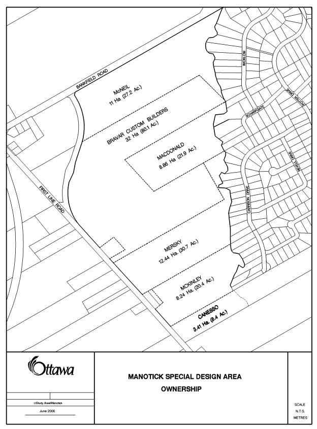
These lands are 76.3 hectares in area and are currently in multiple ownership (see Document 2). The land is largely undeveloped at this time with the bulk being forested or scrub area. There is additionally limited agricultural use of the land and some scattered residential uses.
The Village of Manotick Plan (2001) permitted residential development of these lands without further amendment provided that the following conditions are met:
· A comprehensive development plan has been prepared for the entire area, to the satisfaction of the City of Ottawa, that will facilitate the logical phasing of development in the area (integration of transportation links, parks and open space, pedestrian links, servicing and stormwater) and that will form the basis for various, subsequent plans of subdivision;
· The residential component of the concept plan is comprised exclusively of single detached (Estate) lots;
·
The development concept plan shall ensure that
development in the “SDA Estate Residential and Open Space” is distinct from the
development in the serviced part of the village (larger lot sizes, lower
density, more open space). The plan
shall recognize that parts of the area designated are important groundwater
recharge areas or have soils unsuitable for tile field construction and are
more suited to uses such as passive recreation and/or open space (e.g., nature
trails, active and passive parks, natural areas, etc.);
·
The location and ownership of the recreation and/or
open space areas will be to the satisfaction of Council, and determined in
consultation with the affected land owners and the Manotick community;
·
All development shall be on the basis of private
services. All residential plans of
subdivision must have a density of development that conforms to the Township of
Rideau approved hydrogeological report, “Hydrogeolical Suitability Extension of
Manotick Development Area” by GeoAnalysis dated 4 April, 1989 “(i.e. average
minimum lot size: 0.4 to 0.6 hectares), or as determined by more current
investigations.
Shortly after the approval of the Village of Manotick Plan, interest was expressed by one of the owners within the SDA to proceed with development. The owner was advised regarding the requirement for a comprehensive development plan and what that plan would detail. Staff cautioned the owner that the technical studies upon which the original Manotick Village Plan was based were dated and would require fresh examination in the approval of any SDA concept.
Environmental Management Plan
The Manotick Master Drainage Plan (MDP)
(Robinson Consultants, 1996) was prepared to address water quality requirements
for future development; however, it was not approved by the regulatory
agencies. The MDP recommended that a
subwatershed plan for the Mud Creek/Wilson-Cowan Drain basin should be
completed prior to implementation of any stormwater management plans. The objective of a subwatershed study
is to develop long-term environmental management strategies to protect, enhance
or restore environmental features and functions in light of current and future
demands on the natural resources.
The Mud Creek
Subwatershed Study is currently underway.
Existing environmental information along with the data gathered
in the field in the summers of 2003 and 2004 was used to develop an
understanding of the current environmental health and condition of the Mud
Creek subwatershed in the draft “Existing Conditions Report” (May 2005). The draft Report was presented to the
public at an open house in June 2005.
Subsequently, work on the Subwatershed Study was put on hold pending the
outcome of the Rural Summit that was held in November 2005. A Report on the Subwatershed Study will be
presented to Agriculture and Rural Affairs Committee in Summer 2006
(ACS2006-PGM-POL-0051).
An Environmental Management Plan
(EMP) was prepared and outlines that implementation of a subwatershed plan will
require further detail or coordination of environmental planning and stormwater
management on several sites at the Draft Plan of Subdivision or Site Plan
stage. To support active development
within the Village of Manotick, an Environmental Management Plan (EMP) will be
completed to develop a natural
environment plan and stormwater management solution for the Village. This study will be completed in tandem with
the Mud Creek Subwatershed Study, and is expected to be complete in early
2007.
To support the Concept Plan for the Village of Manotick Special Design Area (SDA), the Environmental Management Plan for this sub-component was initiated in January 2005. The SDA sub-component of the EMP was advanced due to development pressure, and stakeholders have been involved throughout the study. The recommendations from the SDA EMP have been incorporated into the Concept Plan, and will be implemented through development conditions and stormwater site management plans. The SDA EMP sub-component will be integrated into the Village of Manotick EMP, which will follow at a later date for City Council approval and subsequent filing of the document for public review.
DISCUSSION
The purpose of this Report is to gain approval for the Village of Manotick Special Design Area Concept Plan and supporting Environmental Management Plan.
Concept Plan
In September of 2004 a Development Concept Plan for the SDA was submitted by David McManus Engineering on behalf of one of the property owners. The submission included a hydrogeological investigation and a terrain analysis, a conceptual stormwater brief, and a transportation impact study.
Shortly after the submission of the Concept Plan, the Department detailed its plans regarding the ongoing Jock River Reach 2 and Mud Creek Subwatershed Study. This study was anticipated to offer good insight into and offer specific development recommendations and guidelines regarding the SDA lands.
The Jock Reach 2 and Mud Creek Subwatershed Study was intended to balance environmental protection, conservation and rehabilitation with development and land use practices to ensure long term health of the watershed. Staff advised that the draft data (including water quality, groundwater, terrestrial, fisheries and fluvial geomorphology) would be available. With this data in hand, the Subwatershed study could be used for the basis of a detailed Environmental Management Plan (EMP) specific to the SDA. The benefit of waiting for such a study to be completed was the determination of the most efficient criteria for stormwater and environmental management for the SDA as a whole and would eliminate the need for the developers to undertake a study to support the approval of the Concept Plan or future plans of subdivision.
Environmental Management Plan
The SDA Environmental Management Plan (EMP) provides a
natural environment plan and stormwater management solution for the SDA lands
within the Village of Manotick. The EMP
incorporates the findings of the Mud Creek Subwatershed Study that is currently
underway. The EMP includes recommendations
pertaining to natural environment protection, stormwater management design
criteria and conceptual solutions. The recommendations from the EMP have been
incorporated into the Concept Plan.
Environmental Features
The environmental features of the SDA lands include the Mud Creek
corridor, the Kars Esker (groundwater recharge feature), and a woodlot. The recommended measures to protect the
SDA’s environmental features and functions are summarized below:
1. Protect,
where possible, the features and functions of the woodlot through “design with
nature” principles and implementation of relevant Official Plan policies
through the development approval process.
2.
Lands which lie within
the area where development is not permitted should be eventually placed in
public ownership.
3.
The City should
implement a program of public and private environmental stewardship to enhance
the environmental value of the protected lands.
4.
The hydrogeological
constraint area should be excluded from development as a key component in
maintaining the water balance, cool water flows to Mud Creek, and protection of
water quality in the esker and underlying bedrock aquifer. On the remaining lands, measures such as
discharge of roof leaders to pervious and vegetated surfaces should be
implemented to minimize changes to the water balance. Development will be permitted within the esker buffer lands,
provided that restrictions to minimize the risk of contamination is reduced
through conditions of development.
5.
Vegetative cover using
native species should be established and enhanced in the setback/buffer area
through conditions of development approval and encouraged through stewardship
programs in existing developed areas.
Stormwater
Management
Development of the approximately 76.3 hectares
of vacant lands within the SDA will generate increased runoff with resulting
impacts on Mud Creek, its tributaries, and the Kars esker, unless mitigative
measures are implemented.
To address future growth, the recommended stormwater management solution would meet the following recommendations:
1.
The preferred approach
to stormwater within the SDA is a centrally-located end of pipe wet pond
designed according to the criteria in the Ministry of Environment Stormwater
Management Plan Manual (2003).
2.
Stormwater management
for quantity control of major storm events is not recommended since it may
result in increased downstream flows rather than reductions.
3.
Stormwater management
for quality control should be implemented to achieve the enhanced level with
special measures to mitigate increases in water temperature and provide
enhanced phosphorus removal.
4.
Erosion control
storage should not be implemented since it is not effective in reducing the
downstream erosive potential. Measures
should be implemented to minimize the post-development runoff volume with a
target effective imperviousness of 10%.
Subsequent to the completion of the EMP and following review of the applicant-submitted study and public comment, a concept development plan has been developed.
Concept Development
Plan for the Special Design Area
This report summarizes the process and development of the Concept Development Plan for the SDA. In addition, a summary of the two Public Meetings regarding this plan is included herewith.
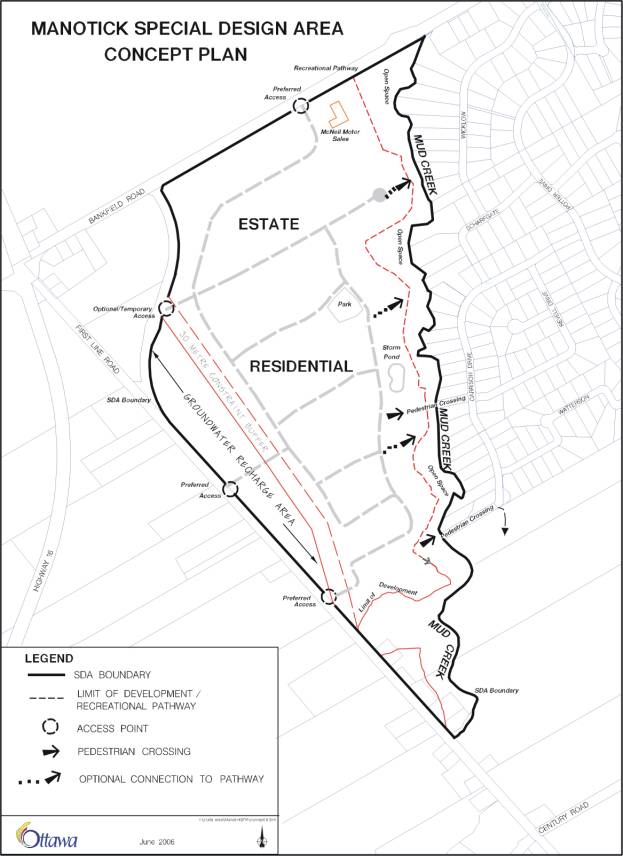
The Concept Plan examines the SDA in greater detail than did the overall Manotick Village Plan; however, definitive development requirements for this area will still be determined by individual plans of subdivision. The Concept Plan sets out overall development principles to be upheld in this area and ensures that, despite fragmented ownership, the area develops in a logical and consistent fashion.
The document is based upon the completion of the Subwatershed/EMP. It is supported by the studies submitted by the developer. The comments made by the public through our consultation have been taken into account.
The Concept Plan confirms and/or establishes the following development requirements:
· Development in the SDA will be single detached residential development based on private servicing.
· Lot sizes of between 0.4 ha and 0.6 will be permitted, or as determined by more current investigations. Precise lot sizes in individual developments will be based upon findings detailed in hydrogeological studies that will be required for approval for each plan of subdivision proposed.
· The concept for the SDA establishes that two access points and one (optional-temporary) access point (vehicular) will be required from First Line Road and one access from Bankfield Road. The location and design of these accesses will be confirmed by future traffic studies required to support individual plans of subdivision.
· The Concept Plan identifies environmentally sensitive lands along the Mud Creek corridor. The Concept Plan requires that no development occur in these lands and that they rest in public ownership. The City plans to develop pathway linkages, where possible, within these lands, along Mud Creek and two pedestrian crossings of the creek are proposed.
· A requirement for a 0.4 – 0.8 hectare neighbourhood park to be centrally located within the SDA lands
· Woodlots within the SDA have been assessed. While not significant enough to warrant City acquisition of the woodlots, they should, as much as possible, be preserved in subsequent plans of subdivision using the Design with Nature/Protection of Vegetation Cover principles.
· The Concept Plan established that there is a significant groundwater recharge area within the SDA. There is to be no development permitted within this area, though the exact boundary of these lands may be revised in the future at plan of subdivision stage if supported by more detailed, City-supported study.
The property owners who will be developing their respective properties through the subdivision approval process will be required to adhere to the above development principles. This represents a positive collaboration between the private landowners and the community stakeholders to ensure that the overall features of the Manotick Special Design Area Concept Plan are protected for the benefit of existing and future residents. The specific details of these principles will be articulated in the final conditions for approval for each respective subdivision application and will form part of the Subdivision Agreements with each owner and the City of Ottawa.
ENVIRONMENTAL IMPLICATIONS
An Environmental Management Plan (EMP) is
prepared where implementation of a subwatershed plan requires further detail or
coordination of environmental planning and stormwater management among several
sites at the Draft or Site Plan stage.
Recommendations from the EMP will be implemented largely through
development conditions and stormwater site management plans. Implementation of the EMP will mitigate the
impacts of future development within the SDA, and its recommendations have been
incorporated into the SDA Concept Plan.
The EMP has been prepared in support of the Concept Plan for the SDA lands. The EMP provides recommendations to address the drainage and stormwater management requirements of anticipated growth and to mitigate the environmental impacts of this development.
CONSULTATION
Two information meetings were held
in the Community to present the Manotick Concept Development Plan. On January 10, 2005 an information session
was held at the Manotick Legion Hall to discuss a Concept Plan submitted to the
City by one of the land owners. The
second information session was held on April 18, 2006 at the Manotick Community
Centre. A summary of comments is
provided in Document 3.
The EMP is following the Master Plan approach of the Class Environmental Assessment process whereby Phases 1and 2 are being satisfied. A summary of public and agency consultation activities is provided below and detailed documentation is provided in the EMP (Document 1).
1. The draft EMP document was circulated to all stakeholders in April 2005. Numerous meetings were held to discuss the details of the document.
2. The draft EMP was circulated to the following agencies for comment: Ministry of Environment, Ministry of Natural Resources, Ministry of Agriculture Food and Rural Affairs, Department of Fisheries and Oceans, and Rideau Valley Conservation Authority.
3.
The Village of
Manotick Special Design Area Concept Plan and supporting Environmental
Management Plan were presented at a joint public open house in April,
2006. The Open House presented
information regarding the project need and justification, existing conditions,
the Class EA Planning process, and the recommended solutions. Approximately 60
people attended the Open House. The Open House was advertised in the local
community newspaper and through direct mailings to the study’s contact list
(agencies, stakeholders, and public).
4.
A Steering Committee guides the development of the Manotick
EMP and the Mud Creek Subwatershed Study.
The Committee includes representatives from various City Departments and
Branches, Rideau Valley Conservation Authority, Federation of Agriculture, the
Ontario Ministries of Natural Resources, Environment, Agriculture Food and Rural
Affairs, and the Federal Department of Fisheries and Oceans. The consultant team of Marshall, Macklin,
Monaghan and Water Earth Sciences Associates are preparing the studies. Local members of the community participate
as Community Advisors and work with the Steering Committee to ensure the Study
reflects local community values.
5. The Environmental Advisory Committee and the Ottawa Forest and Greenspace Advisory Committee were invited to review and provide comments on the Concept Plan and EMP.
6. The Ward Councillor has been briefed on the report recommendations.
FINANCIAL
IMPLICATIONS
The endorsement of the EMP and the Concept Plan
does not have specific financial implications for the City at this time. The
final design and construction of the recommended stormwater management
facilities will be paid for by the development proponent(s). These facilities
will ultimately be assumed by the City, resulting in future operational and
maintenance costs. These costs, and any additional funding requirements to
implement the EMP recommendations, will be brought forward through the City’s
annual budgeting process.
SUPPORTING
DOCUMENTATION
Document 3 Consultation Details
Document 4 Concept
Development Plan
Document 5 Village
of Manotick EMP (Distributed separately and on file with the City Clerk)
DISPOSITION
1. Planning and Growth Management will ensure that the recommendations of the Village of Manotick Environmental Management Plan, Special Design Area Component are properly implemented through the development approvals process.
2. The Village of Manotick Environmental Management Plan, Special Design Area Component will be integrated into the Village of Manotick Environmental Management Plan scheduled for completion in early 2007. The Village EMP will follow at a later date for City Council approval and subsequent filing of the document for public review.
LOCATION MAP DOCUMENT
1

PROPERTY OWNERSHIP DOCUMENT 2
CONSULTATION DETAILS DOCUMENT
3
Two information meetings were held in the
Community. Overall there appears to be
a general public support for the Concept Development Plan with the caveat that
development is done responsibly and that certain conditions are met such as:
a)
Detailed
hydrogeological studies for each development supporting lot sizes.
b)
A
review of traffic volumes and location of access points for each development
submission.
c)
Maintain
residential character of neighborhood.
d)
Protect
environmentally sensitive land.
e)
Encourage
larger lot areas.
f)
Provide
parkland and pathways.
g)
Preservation
of greenspaces
h)
No
development on the groundwater recharge area.
Aside from the comments made at the information
meetings a total of 94 responses were received by the City of Ottawa. Approximately 90% of the comments offered
support of the Concept Plan proposal.
Below is a summary of comments heard at the
information meetings.
PUBLIC COMMENTS
Meeting of January 10, 2005 ( In attendance: 30)
Comment:
What type of sewage and water services are being proposed?
Response:
The Special Design Area will be privately serviced.
Comment:
What
effect will the proposed development have on the present water levels,
particularly on Mud Creek and downstream?
Response:
The
Hydrogeological and Terrain analysis will review the impact on current water
levels. As for water levels in Mud
Creek, there are restricitions in place to control stormwater. A more detailed stormwater study will be
filed with the plans of subdivision to address this issue.
Comment:
What
impact will this development have on the volume of traffic on First Line Road
particularly between Bankfield Road and the Village of Kars? Will First Line Road be widened to
accommodate this?
Response:
Aside
from the two access points on First Line, an additional access will be provided
on Bankfield Road. Most cars will
access directly onto Bankfield or from First Line. Traffic Impact studies will be requested as each plan of
subdivision is reviewed.
Comment:
We
would like to see traffic lights and turning lanes at First Line and Bankfield
Roads to allow proper flow of traffic.
Bankfield Road should be widened and sidewalks should be provided along
First Line Road and the interior of the site.
Response:
Depending
on the results of the traffic studies, some road modifications may be required.
Comment:
Will
there be a bridge across Mud Creek to connect to the old estates to elevate
traffic flow and allow OC Transpo and bike path use?
Response:
The
Concept Plan proposes pedestrian bridge crossings only.
Comment:
As a resident of First Line I am concerned with the number of cars that will be added to First Line Road which is narrow and fast moving. There are a number of farmers who drive wide and slow moving tractors on First Line Road. The development will be adding more and fast moving cars.
Response:
A
Traffic Impact study was submitted with the Concept Development Plan. The study
takes into account such things as grade elevations, site lines etc. The study is currently under review.
Comment:
The new development should not have a vehicular connection (across Mud Creek) to the existing Manotick Estates. The roads in the existing estates could not handle new traffic from the new development.
Response:
The City is currently looking at a pedestrian crossing only.
Comment:
Pedestrian and bike paths should be required.
Response:
A system of pathways is proposed.
Comment:
A ban on pesticide use in this area to protect Mud Creek and Kars Esker habitat.
Comment:
Are there any plans to protect the green space and the environmental features of the site?
Response:
Yes. City staff are currently looking at an environmental management plan for this site.
Comment:
Stormwater ponds should be required to ensure water entering the Mud Creek and Rideau water systems is safe to support aquatic life.
Response:
The Conceptual Stormwater report submitted with the Concept Development Plan currently proposes stormwater ponds to address water quality requirements.
Comment:
Is the City aware of the esker that runs along First Line Road? What type of development is the City going to permit in this area?
Response:
The City is aware of the esker; however, the exact location is still under review. Staff recommend that no development will be permitted on the esker land.
Comment:
What type of housing is being proposed?
Response:
Single detached housing is proposed.
Comment:
Will any of the existing homes along First Line be removed?
Response:
We are not aware that the existing homes will be removed.
Meeting of April 18, 2006. (In attendance 65)
Comment:
Will the pathway be located near the bottom of the Creek?
Response:
The pathway will, for the most part, be located on the table lands outside the valley of the creek.
Comment:
What does the “Open Space” category on the plan mean? Will all the trees and vegetation be removed?
Response: The area identified as open space will remain in its current state. With the exception of a pathway, no vegetation will be removed.
Comment:
Will the groundwater area as identified on the plan be protected? Who will own the protected area.
Response:
No development (i.e. buildings, septic systems etc.) will be permitted in the groundwater protection area. As for ownership, there are a number of options available. This area could be acquired by the City. This is currently under discussion. Another option would be to permit private ownership and restrict the type of development via a zoning by-law.
Comment:
The Manotick Community Association support this plan. Is there a chance that this will change before it is approved?
Response:
As a result of this meeting and or new technical information, this plan could change. The Community will be notified if there are any major revisions to this plan.
Comment:
What will the lot sizes be?
Response:
The current policies permit an average minimum lot size of
0.4 to 0.6 hectares. The policy also
permits further investigation. The
studies currently before the City propose a minimum lot area of 1950 m2 (0.2
hectares).
Comment:
Does the Rideau Valley Conservation Authority have control over what can be developed in the flood plain?
Response:
The Conservation Authority controls all development aspects of the floodplain.
Comment:
Who owns the creek?
Response:
Currently Mud Creek is in private ownership
Comment:
What dictates the approval of lot sizes?
Response:
The Hydrogeological and Terrain analysis and any accompanying environmental studies are generally the documents used in reviewing lot areas.
Comment:
Will the City be taking ownership of the lands on the esker to ensure nothing is developed?
Response:
The City is currently looking at all options for protection of the esker lands.
Comments
For the record, we own land in the northern portion of the Special Design Area and we do not agree to having the creek lands transferred to the City without compensation.
I cannot see how the City can approve more development in the Manotick area given the volume of traffic on Bankfield Road.
COUNCILLOR’S COMMENTS
The Councillor attended all the information meetings for the Concept Development and Environmental Management Plans and is aware of City staff’s recommendations.
COMMUNITY ORGANIZATION COMMENTS
First Line
Neighbourhood Association (FLNA)
The First Line Neighbourhood Association (FLNA), current membership available upon request, is not opposed to development of the Manotick Special Design Area (SDA). However, the FLNA continues to have serious concerns that development be done responsibly in order to prevent adverse conditions on the existing neighbourhood. The FLNA also desires to maintain the residential character of First Line Road according to the ideology outlined in the Manotick SDA Development Concept Plan. Thus, we provide comments below.
Comment:
Request to maintain minimum lot sizes of .89 acres – or greater, as contained in the Manotick Special Design Area (SDA) Concept Plan. Developers are proposing rezoning as follows;
Bravar (Maple Creek Estates) .483 acres (0.19 ha)
McKinley (Waterson) .500 acres (0.2 ha)
Leimerk .700 acres (0.28 ha)
Response:
The SDA concept does illustrate larger lots; however, does permit for smaller lot sizes if supported by detailed hydrogeological study.
Comment:
Request to study effect of Kars Esker on development.
Response:
No development will be permitted in the esker.
Comment:
Request to study the safety of access roads onto First Line Road, especially the southern-most proposed access with poor visibility.
Response:
Traffic studies have been undertaken for the concept development plan. As a result both accesses to First Line Road have been altered on the recommended Concept Plan for more optimum site lines.
Comment:
Request to study additional traffic impact on First Line Road if reduced lot size is approved.
Request to maintain residential character of First Line Road with the following recommendations;
- Include several residential lots with frontage on First Line Road.
- Incorporate internal “frontage” road with lots facing First Line Road as is being done in the Chapman Mills development on Prince of Wales.
- Mandate landscaping solutions rather than fences for any lots backing onto First Line Road.
Response:
Staff can certainly encourage lots fronting on First Line Road with access from an internal roadway. However development is not at that stage yet.
Comment:
Status of request to incorporate mature trees into subdivision, where feasible.
Response:
The requirement to review tree preservation and planting will be implemented through the conditions of final approval of the subdivision.
Comment:
Status of request to utilize passive street lighting (as in the older Manotick Estates) rather than extensive “cobra” lighting in the new Manotick Estates.
Response:
In most cases marker lighting will be provided (one per intersection). Aside from “cobra” design, there is a variety of decorative lighting standards available to the developer.
Comment:
Status of request to study George Potter home for possible historical preservation.
Response:
The Potter home is not included on the City of Ottawa Heritage Reference list. Staff of the Heritage Services Unit have examined the building and it appears that a number of the architectural elements have been replaced. There are no plans to reassess this matter.
Comment:
Status of MDS study as well as proposed impact upon neighbouring farms.
Response:
Issues regarding impact on existing farm operations within and/or adjacent to the Village boundary would have been addressed when the new boundaries were approved in the early 90’s (Official Plan Amendment Rideau Official Plan).
Rural Pathways and
Manotick Community Association
Comments/Observations
Congratulations to City Planners and Staff for the fine work that has gone into the Environmental Management Plan for the SDA. The report is one of the best of its kind that I have seen. I have also studied the plan for the Jock River Watershed and it is of the same quality and very meaningful for the future of our area. And special congratulations for the Concept Plan for the SDA, for incorporating the environmental recommendations and supporting the spirit of the Manotick Secondary Plan, Ottawa’s Official Plan and CAUSE study. I am sure that you have heard the clear voice of the Manotick Community with regard to the desire for recreational space that is connected by usable recreational corridors, features that are lacking in the community. I have lived in Manotick for 35 years and have walked and skied the creek beds, farm lanes and forest trails over the area. In the last decade, many of these features have rapidly disappeared to large lot development.. I have also cycled around the area all my time here, but in Manotick, it has always been on a street – we have never had a dedicated bicycle path anywhere. The path along Mud Creek will be a good start and may lead to further such corridors. A connection to Beryl Gaffney and the Jock River trail system is still an objective.
Over my years in Manotick, I have worked on projects that
have led to community development, in the sense of big “C”. I founded a
performing arts group that filled a void in the cultural life of the village; I
have worked on the development of Dickinson Square (the future of which is
currently of great concern); I have led groups of skiers into areas of superb
cross-country skiing. We have a strong community spirit and regret the
effectively gated-community and sense of entitlement that has arisen with the
development of estate-size lots. In the spirit of the late Jane Jacobson, we
need to renew the village community as such in Manotick. To this end, we hope
that you will stand by the provisions of the SDA concept plan, for which the
greater community will be grateful.
ADVISORY COMMITTEE COMMENTS
The Manotick Secondary Plan: Special Design Area (SDA):
The SDA takes into account the following conditions as set by the City for approval of development on this site
The Concept Plan shall take into account:
· Servicing/Stormwater management
· Transportation linkages
· Integration of transportation
· Provision for parks and open space
· Pedestrian links
Protection of groundwater recharge areas:
The present forest on the South–west portion of this parcel is a large groundwater recharge area. A large portion of this forest is going to be lost and only certain trees are proposed to be preserved with certain individual lots. Only a small portion of the most southwestern portion of the woodlot is being kept as a groundwater recharge area. OFGAC does not feel this is enough. We are concerned that not enough information has been presented on this recharge area and the effect of cutting it back to such a small area. We would like to see a more comprehensive study done on how much this woodlot actually functions as a water recharge source.
OFGAC has concerns that so much of the woodlot is going to be lost. This is not in keeping in with the Official Plan policy, the Manotick Secondary Plan and the SDA which state:
“In support of the Official Plan objective for 30% tree cover, all applications for subdivision approval will be supported by a tree preservation and protection plan and a landscaping planting plan. In addition, applicants will be required to “design with nature” in accordance with Official Plan policies”
The removal of the majority of this forest is not in keeping with the Official Plan policy of maintaining a 30% tree cover. We would like to know the percentage of the woodlot that will be lost in the present proposal.
The Manotick Secondary Plan states:
“In keeping with the policies of the Secondary Plan a linear pathway corridor will be established in conjunction with the Mud Creek lands. The specific location of the pathway will depend on the stability of the lands within the development setbacks.”
OFGAC would like to see a permeable path created and would also like to be assured that the pathway will be far enough away from the slope of the creek. This will prevent a situation, which has occurred along the Jock River where the slope was unstable near the path and the soil is eroding into the river.
The SDA also states that transportation linkages and integration will be part of the concept plan. Based on information provided at the public meeting in Manotick on May 16th it does not appear that any transportation plans exists. There are already serious problems with traffic and safety in this area and adding 200 homes will simply add to the problems unless a concrete proposal is provided for handling the extra cars from this development.
OFGAC Recommendations:
- Increase the lot sizes from the present proposed 1950 square meters (< ½ acre) to 1-2 acres (0.4 ha – 0.8 ha)
- Maintain more of the forested area for water recharge and for canopy cover.
- Inform the new homeowners about the future expense they will have to bear when City water and sewage services come on line to their subdivision.
CONCEPT DEVELOPMENT PLAN DOCUMENT
4
Concept
Plan
Special Design Area
Village of Manotick
June 2006
Concept Plan for the Village of Manotick
Special Design Area
Preamble
This document has been developed by the City of Ottawa with the support and input of the development community, property owners and through public consultation.
A number of technical documents have been used as a basis for the development standards contained herein. These documents should be read in conjunction with this Concept Plan as they offer greater detail and technical support for the principles expressed. These studies are as follows:
- Jock Reach 2 and Mud Creek Subwatershed Study (City of Ottawa 2005)
- Environmental Management Plan for the Village of Manotick Special Design Area
- Transportation Impact Analysis
Further, the Concept Plan attached hereto as Appendix A forms part of this document.
The Special Design Area
The Special Design Area, or SDA in the Village of Manotick is a triangular track of land approximately 76.3 hectares in size and is bounded by Bankfield Road to the north, First Line Road to the west and Mud Creek to the southeast. The lands are in parceled into six (6) different ownerships. The property is largely undeveloped at this time with the bulk being forested or scrub area. There is additionally limited agricultural use of the land and some scattered residential uses.
Current Designation and Zoning
The land is currently designated Special Design Area (SDA) Estate Residential and Open Space, by the City of Ottawa Official Plan. The property is zoned D- Development and A1 Restricted Rural.
The original Village of Manotick Plan (2001) permitted residential development of these lands without further amendment provided that the following conditions are met:
· A comprehensive development plan has been prepared for the entire area, to the satisfaction of the City of Ottawa, that will facilitate logical phasing of the development in the area (the integration of transportation links, parks and open space, pedestrian links, servicing and stormwater) and that it will form the basis for various and subsequent plans of subdivision;
· The residential component of these lands is comprised exclusively of Single Detached (Estate) lots.
·
The development concept plan shall ensure that
development in the “SDA Estate Residential and Open Space” is distinct from the
development in the serviced part of the village (larger lot sizes, lower
density, more open space). The plan
shall recognize that parts of the area designated are important groundwater
recharge areas or have soils unsuitable for tile field construction that are
more suited to uses such as recreation and/or open space (e.g., nature trails,
active and passive parks, natural areas, etc.);
·
The location and ownership of the recreation and/or
open space areas will be to the satisfaction of Council, and determined in
consultation with the affected land owners and the Manotick community;
· All development shall be on the basis of private services. All residential plans of subdivision must have a density of development that conforms to the Township of Rideau approved hydrogeological report, “Hydrogeolical Suitability Extension of Manotick Development Area” by GeoAnalysis dated 4 April, 1989 “(i.e. average minimum lot size: 0.4 to 0.6 hectares), or as determined by more current investigations
Development Permitted
Development in the SDA will be single detached residential development based on private servicing (estate development). This was the form of development permitted by means of the original Manotick Village Plan and the development of this concept has upheld this development form.
Lot sizes permitted in the Special Design Area will range, generally, from a minimum of .4 ha to a maximum of .6 ha. or as determined by more current investigations. Lot sizing will be confirmed at individual plan of subdivision stage upon submission of detailed development plans and supporting technical studies and shall be subject to the approval of the City of Ottawa.
Transportation Requirements
Based upon the number of units projected, it has been determined that two (2) vehicular accesses will be required from First Line Road. One (1) access will be required from Bankfield Road. One optional access (temporary) has also been identified off of First Line Road.
Subsequent and more detailed transportation analysis will support the precise location of these accesses. This will occur with the development of individual plans of subdivision.
Environmental Management Plan (EMP) Findings
Mud Creek
The EMP examined Mud Creek in detail and determined flood plain, areas with slope stability issues, and a limit of development along Mud Creek. This setback is illustrated on the attached Concept Plan.
These lands will be held in public ownership and will be required to be dedicated to the City of Ottawa as a condition of future development approvals. The City intends to develop a pathway system along the Mud Creek corridor.
Woodlot Analysis
A good portion of the SDA lands are currently forested, or at least, left to scrub as agricultural uses ceased. There is one woodlot on the lands which is fairly substantial and mature located in the northeast area of the property. This woodlot was not assessed as being regionally significant and is therefore not set aside for acquisition (and preserved from development) by the City of Ottawa.
That being said, good planning practices should be upheld in the development of this property. Individual plans of subdivision in this area will be required to preserve as much of the woodlot as reasonably possible by following the “Design with Nature/Protection of Vegetation Cover” principals.
Groundwater Recharge
Area
One of the more significant findings of the Environmental Management Plan examined the private servicing need of development and the hydrogeological capabilities of the Special Design Area. It was determined through significant examination and study that a portion of lands that run along First Line Road on the westerly boundary of the SDA should be set aside as a groundwater recharge area.
No development will be permitted in the recharge area other than one of the vehicular accesses required from First Line Road. The westerly boundary of these lands has been set by First Line Road. The easterly boundary, while illustrated on the attached concept plan, may be further refined in the future by means of submission of technical studies required to support the approval of individual plans of subdivision.
Stormwater Management
The SDA will generate increased runoff with
resulting impacts on Mud Creek, its tributaries, and the Kars esker, unless
mitigative measures are implemented.
To address future growth, the recommended stormwater management solution must consider the recommendations of the EMP.
Parkland/Pathways
The policies of the Village of Manotick Official Plan encouraged a pedestrian oriented Village by connecting the Core to the surrounding neighbourhoods through a limited system of pathways. In keeping with the policies, a linear pathway corridor will be established in conjunction with the Mud Creek lands, with development of this access to occur largely within the dedicated lands. However, it should be noted that there are certain areas where slope stability or other environmental issues may not allow for the development of the pathway within the dedicated lands. In these instances the City will examine the most suitable means of ensuring a continuous pathway corridor including the acquisition of table land through the subdivision approval process.
It has been determined that two pedestrian crossings of Mud Creek will link into the proposed pathway system. In the future the most southerly pedestrian crossing will connect to the east towards the Rideau River through the southern expansion lands.
There will also be a requirement for a 0.4 –0.8 hectare (1-2 acre) neighbourhood park to be centrally located within the SDA lands. The neighbourhood park will address the immediate recreational needs of the new residents.