|
9. ZONING - 870 March Road AND parts of 1001 and 1045 Klondike Road |
Committee recommendation
That Council approve amendments to the
former City of Kanata Zoning By-laws 74-79 and 164-93 to change the zoning of
870 March Road and parts of 1001 and 1045 Klondike Road from Estate Residential
(ER) to Residential Type 3A - Exception x (R3A-x), Residential Type 5A -
Exception x (R5A-x), Open Space Type 1 (OS1), Open Space Type 1 - Exception x
(OS1-x), and General Commercial Special Zone (CG-x) as shown on Document 1 and
as detailed in Document 2.
Recommandation du Comité
Que le Conseil approuve des modifications des Règlements de zonage 74-79 et
164-93 de l'ancienne Ville de Kanata qui auraient pour effet de rezoner le 870,
chemin March et des parties du 1001 et du 1045, chemin Klondike de Zone de
domaines résidentiels (ER) à Zone résidentielle de type 3A avec exception x
(R3A-x), à Zone résidentielle de type 5A avec exception x (R5A-x), à Aire
ouverte de type 1 (OS1), à Aire ouverte de type 1 avec exception x (OS1-x) et à
Zone commerciale générale spéciale (CG-x), tel que l'indique le document 1 et
que le montre en détail le document 2.
Documentation
1. A/Deputy City Manager's report
(Planning and Growth Management) dated
12 June 2006 (ACS2006-PGM-APR-0100).
2. E-mail Correspondence from Mr. Robert
Gregory, President, March Rural Community Association dated June 25, 2006,
expressing concerns related to Stormwater Ponds, Shirley’s Brook set-backs and
Traffic at the Klondike/March Road intersection, is held on file with the City
Clerk.
Report
to/Rapport au :
Planning and Environment Committee
Comité de l'urbanisme et de
l'environnement
and Council / et au Conseil
12 June 2006 / le 12 juin 2006
Submitted by/Soumis par : John L. Moser, A/Deputy City Manager/
Directeur municipal adjoint par intérim,
Planning and Growth Management / Urbanisme
et Gestion de la croissance
Contact Person/Personne ressource : Grant Lindsay,
Manager / Gestionnaire
Development Approvals / Approbation des demandes d'aménagement
(613) 580-2424 x13242, Grant.Lindsay@ottawa.ca
|
SUBJECT: |
ZONING - 870 MARCH ROAD AND PARTS OF 1001
AND 1045 KLONDIKE ROAD (FILE NO. D02-02-04-0077) |
|
|
|
|
OBJET : |
ZONAGE - 870, CHEMIN
MARCH ET PARTIES DES 1001 ET 1045, CHEMIN KLONDIKE |
REPORT RECOMMENDATION
That the Planning and Environment Committee recommend Council approve amendments to the former City of Kanata Zoning By-laws 74-79 and 164-93 to change the zoning of 870 March Road and parts of 1001 and 1045 Klondike Road from Estate Residential (ER) to Residential Type 3A - Exception x (R3A-x), Residential Type 5A - Exception x (R5A-x), Open Space Type 1 (OS1), Open Space Type 1 - Exception x (OS1-x), and General Commercial Special Zone (CG-x) as shown on Document 1 and as detailed in Document 2.
RECOMMANDATION DU RAPPORT
Que le Comité de l'urbanisme et de l'environnement recommande au Conseil
d'approuver des modifications des Règlements de zonage 74-79 et 164-93 de
l'ancienne Ville de Kanata qui auraient pour effet de rezoner le 870, chemin
March et des parties du 1001 et du 1045, chemin Klondike de Zone de domaines
résidentiels (ER) à Zone résidentielle de type 3A avec exception x (R3A-x), à
Zone résidentielle de type 5A avec exception x (R5A-x), à Aire ouverte de type
1 (OS1), à Aire ouverte de type 1 avec exception x (OS1-x) et à Zone
commerciale générale spéciale (CG-x), tel que l'indique le document 1 et que le
montre en détail le document 2.
BACKGROUND
The subject lands are 39.4 hectares
in area and are bounded by Klondike Road to the south, the Ottawa Central
Railway to the east, March Road and Shirley’s Brook to the west, and the urban
boundary to the north. These lands are
commonly known as the ‘Kanata North Lands’.
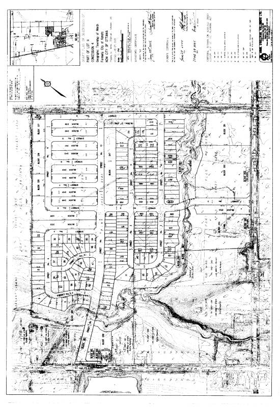
The draft plan of subdivision
includes a mixture of single detached residential units, semi-detached and
townhouse units, two six-storey apartment buildings, a 1.6-hectare park block,
a commercial block and floodplain protection corridor along the Shirley’s
Brook. Draft Plan approval was granted
on September 13, 2005. As required by a
condition of draft plan approval, the applicant has filed this subject Zoning
By-law Amendment for consideration and approval.
DISCUSSION
City Council Approved Official Plan
The subject lands are currently designated
Enterprise Area within the City Council Approved Official Plan. The Enterprise Area policies identify areas
where office, industry and commercial are to be the primary land uses. The Enterprise policies also afford the
opportunity for residential development.
A special exception has been provided to the
subject lands to permit residential development at a minimum 35 units per
hectare. The draft plan of subdivision,
as shown in Document 3 meets the minimum density requirement. The 1.48 hectares
block dedicated for the two apartment buildings will provide 132 units, which
is a net residential density of 89.19 units per hectare. The residential
density for the subdivision without the apartment block is 31.8 units per
hectare. The overall net residential density of the subdivision (including the
apartment block) is 35.6 units per hectare, thereby, meeting the City Council
Approved Official Plan's requirement of a minimum density of 35 units per
hectare.
Former Regional Official Plan / Former City of
Kanata Official Plan
The proposed development lands were part of an
area that was subject to a series of Planning studies starting in the early
1990s and generally referred to as the "Kanata North Urban Expansion
Area". The original Kanata North
Urban Expansion Study completed in 1991 recommended that the subject lands be
developed for residential purposes.
The Kanata North Expansion Area (KNUEA) was
further added as a special designation to the 1997 Official Plan of the former
Region of Ottawa-Carleton.
Subsequently, a study titled Kanata North Urban Expansion Study and the
Kanata North Urban Expansion Area Study Concept Plan was provided to support
the amendments to the Official Plan of both the former City of Kanata (OPA No.
58) and Region (ROPA No. 8) changing the designations to General Urban Area and
Business Park.
In 2002, the owners of the subject 'Kanata
North Lands' obtained approval for amendments to the Official Plans of both the
former City of Kanata (OPA No. 66) and former Region (ROPA No. 25) to permit
residential uses to the Business Park.
OPA No. 66 amended the designation of the subject lands north of
Klondike Road to restricted Industrial - Special Policy Area (MR-4). The MR-4 policies require the development of
an overall concept plan for the lands, which must meet and achieve specific
policies so that the lands can develop as a planned community. Specific to the policies implemented for OPA
No. 66 is the requirement that a minimum density of 35 units per net hectare is
to be achieved for all residential development within the MR-4 lands.
Proposed Zoning By-Law Amendment
The subject lands, also known as the Brookside
Subdivision, received draft approval (D07-16-04-0014) September 13, 2005. The
subdivision is currently zoned Estate Residential (ER) and as a condition of
draft approval, the applicant must rezone the property to facilitate the draft
plan of subdivision. This application
for a Zoning By-law Amendment reflects the residential, commercial, and open
space components of the draft plan of subdivision, as shown in Document 3.
As identified in Document 2, Details of
Recommended Zoning, the lands are to be removed from the March Rural Zoning
By-law 74-79 and added to Zoning By-law 164-93, Riddell Village (Briar
Ridge). The proposed rezoning includes
lands to be zoned: Residential Type 3A - exception x (R3A-x), Residential Type
5A - exception x, General Commercial Special Zone (CG-x), Open Space Type 1
(OS1), and Open Space Type 1 - exception x (OS1-x).
The proposed Residential Type 3A - exception x
(R3A-x) Zone will include modifications to the standard R3A Zone by increasing
the lot coverage to 50% from 40% and removing the maximum density requirement.
The proposed Residential Type 5A - exception x
(R5A-x) will include modifications to the standard R5A Zone by replacing the
maximum density zoning provision of 35 units per hectare to a minimum density
of 90 units per hectare in order to meet the City Council Approved Official
Plan minimum density requirement of 35 units per hectare for the overall
subdivision.
The proposed General Commercial Special Zone
(CG-x) will modify the standard CG Zone by decreasing the minimum front,
exterior, interior, and rear yard depths to increase the developable area
within the commercial block as it is L-shaped with multiple yard setback
requirements.
The proposed Open Space Type 1 - exception 1
(OS1-x) will include modifications to the standard Open Space Type 1 Zone by
limiting any development within the Shirley's Brook creek corridor without
specific approval from the City, Conservation Authority, and any other
applicable Federal or Provincial authority.
The rezoning is appropriate because it meets
the policy objectives with the Council Approved Official Plan, and the specific
density minimum of 35 units per hectare has been satisfied within the draft
plan of subdivision.
ENVIRONMENTAL IMPLICATIONS
Specific regard to the Flood Plain constraints
along the Shirley’s Brook corridor as part of any development application have
been identified within the Council approved Kanata North
Environmental/Stormwater Management Plan (KNEMP). In accordance with the
recommendations and requirements of the KNEMP, a detailed Floodway/Flood Fringe
Analysis was prepared to support the submission of draft plan approval and
accompanying Zoning By-law amendment application. Accordingly, special conditions have been included in the draft
conditions of approval, which included a special or specific zoning to identify
and protect the Shirley’s Brook corridor.
The environmental integrity of the Shirley’s Brook corridor is to be
protected as part of this Zoning By-law amendment by implementing a special
exception open space zoning that will not permit alterations to the corridor
lands without approval from the City, Conservation Authority, and any other applicable
Federal or Provincial authority.
The City initiative to facilitate the
protection of the corridor lands not only includes the subdivision lands, it
will also incorporate the lands along the extent of Shirley’s Brook, from March
Road to March Valley Drive.
Accordingly, the storm water management facilities to be constructed to
support the draft plan of subdivision will be rezoned appropriately at such
time as those lands between the Ottawa Central Railway and March Valley Drive
are rezoned. It is anticipated that
application will be made to the City in the fall of 2006.
RURAL IMPLICATIONS
The Zoning By-law amendment will remove the subject lands from the March Rural Zoning By‑law 74-79 and incorporate said lands into the urban Zoning By-law 164-93, Riddell Village (Briar Ridge). The subject lands are within the urban boundary; therefore bring the lands into conformity with the City Council Approved Official Plan.
CONSULTATION
Notice of this application was carried out in
accordance with the City's Public Notification and Consultation Policy. The
Ward Councillor is aware of this application and the staff recommendation. The
City did not receive any negative comments or opposition to this
application. Comments from the public
are summarized in Document 4.
FINANCIAL IMPLICATIONS
N/A
APPLICATION PROCESS
TIMELINE STATUS
The application was not processed by the
"On-Time Decision Date" established for the processing of Zoning
By-Law amendments due to the completion of the Shirley's Brook floodplain
/floodway analysis.
SUPPORTING DOCUMENTATION
Document 1 Location
Map
Document 2 Details
of Recommended Zoning
Document 3 Draft
Plan of Subdivision
Document 4 Public
Consultation
DISPOSITION
Corporate Services Department, City Clerk's Branch to notify the owner (Klondike Development Inc., c/o Cavanaugh Construction, 9094 Highway #7, RR #2, Ashton, ON K0A 1B0), applicant (Greg Winters, Novatech Engineering Consulting Ltd., Suite 200 - 240 Michael Cowpland, Ottawa, ON K2M 1P6), Signs.ca, 866 Campbell Avenue, Ottawa, ON K2A 2C5, and Ghislain Lamarche, Program Manager, Assessment, Financial Services Branch (Mail Code: 26-76) of City Council's decision.
Planning and Growth Management Department to prepare the implementing by-law, forward to Legal Services Branch and undertake the statutory notification.
Corporate Services Department, Legal Services Branch to forward the implementing by-law to City Council.
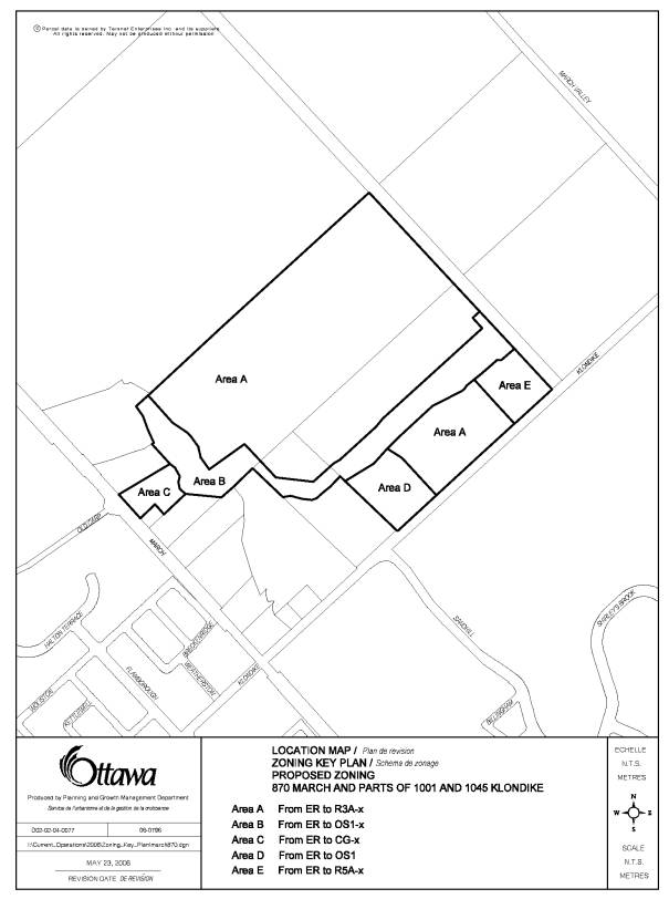
DOCUMENT 1
LOCATION MAP
DOCUMENT 2
DETAILS OF RECOMMENDED ZONING
(1) Schedule ‘A’ of By-law 74-79 will be changed by deleting the subject lands.
(2) Schedule ‘A’ of By-law 164-93 will be changed by adding the subject lands.
(3) The subject lands will be rezoned as follows:
(i) Area A on Document 1 be changed from Estate residential (ER), By-law 74-79, to Residential Type 3A – exception x (R3A-x) Zone, By-law 164-93
(ii) Area B on Document 1 be changed from Estate residential (ER), By-law 74-79 to Open Space Type 1 – exception x (OS1-x) Zone, By-law 164-93
(iii) Area C on Document 1 be changed from Estate residential (ER), By-law 74-79, to General Commercial Special Zone (CG-x), Zoning By-law 164-93.
(iv) Area D on Document 1 be changed from Estate residential (ER), By-law 74-79 to Open Space Type 1 (OS1) Zone, By-law 164-93
(v) Area E on Document 1 be changed from Estate residential (ER), By-law 74-79 to Residential Type 5A – exception x (R5A-x) Zone, By-law 164-93
(4) A new R3A special zone will be added to By-law 164-93 including the following provisions:
(a) the minimum front yard depth will be 4.5 metres
(b) the minimum exterior side yard width will be 4.5 metres
(c) the maximum main building coverage will be 50%
(d) no maximum or minimum density
(e) no minimum amenity requirement
(f) two parking spaces will be required for a multiple-attached dwelling
(g) one parking space will be permitted in a driveway within the boulevard or a public street provided the vehicle is not parked within 1.0 m of the curb or the travelled portion of the roadway. Commercial or recreational vehicles will not be permitted in a driveway within the boulevard.
(h) where a driveway crosses or will cross a sidewalk, then the minimum distance from the lot line the driveway crosses to a garage will be 5.0 metres
(i) the lot line that is the hypotenuse or the longest line of a sight triangle is deemed not to be a lot line for yard depth requirements.
(5) A new CG1 special zone will be added to By-law 164-93 including the following provisions:
(a) the minimum front yard depth will be 6.0 metres
(b) the minimum exterior side yard width will be 6.0 metres.
(c) the minimum interior side yard width will be 4.5 metres
(d) the minimum rear yard depth will be 4.5 metres
(6) A new R5A special zone will be added to By-law 164-93 including the following provisions:
(a) the minimum
density for apartment buildings will be 89 units per hectare
(7) A new OS1 special zone will be added to By-law 164-93 including the following provision:
any permitted use in the OS1-x special zone shall be required to be in accordance with the approved “Floodway/Floodfringe Analysis” and “Shirley’s Brook Pathway and Riparian Planting Plan”, as required by, and in accordance with the Kanata North Environmental/Stormwater Management Plan (KNEMP), and no buildings or structures shall be permitted, and no fill or vegetation shall be placed or removed except where such buildings, structures and fill or vegetation are intended for flood or erosion control or for storm water management purposes, and approved by the City, Mississippi Valley Conservation Authority and other applicable Provincial or Federal authorities.
DOCUMENT 3
DRAFT PLAN OF SUBDIVISION
DOCUMENT 4
CONSULTATION DETAILS
NOTIFICATION AND CONSULTATION PROCESS
Notification and public consultation was
undertaken in accordance with the Public Notification and Public Consultation
Policy approved by Council for Zoning By-law amendments.
The Ward Councillor is aware of this
application and the staff recommendation.
The City did not receive any negative comments or opposition to this
application. The following comments
were provided in accordance with the public notification for the associated
draft approved Plan of Subdivision, and remain relevant with regards to the
subject Zoning By-law Amendment application.
SUMMARY OF PUBLIC COMMENTS
Councillor Peggy Feltmate provided support for
the Draft Plan of Subdivision, contingent on the coordination of construction
for the subdivision with the construction of the March Road expansion. Specific conditions have been incorporated
into the draft plan approval of the subdivision that specifically speaks to the
requirement for coordination of the construction schedule for the March Road
expansion.
A public meeting, in accordance with Section 51
of the Planning Act, was held on September 15, 2004 for the Draft Plan of
Subdivision application. Comments were
provided from the public that generally included inquiry or concern over
traffic on March Road, preservation of the natural or environmental features,
and the location and programming to be provided in the future park block.
STAFF RESPONSE
The comments were duly noted and have been
incorporated into the conditions of draft approval for the Plan of
Subdivision.
Staff noted to those that have made public
comment and to Councillor Feltmate that a construction schedule, as approved by
the City, will be in place prior to occupancy of the units within the
subdivision. The only alternative is that
the developer will be required, as conditioned through draft approval of the
Plan of Subdivision, to undertake interim construction measures for March Road
and Klondike Road prior to the occupancy of the units within the subdivision.
In conjunction with the draft plan conditions,
the proposed zoning for the subdivision has recognized the sensitivity of the
Shirley's Brook corridor by implementing an Open Space - exception zone (OS1-x)
for this area. Within the OS1-x Zone, development will be limited within the
Shirley’s Brook creek corridor and be in accordance with the approved
“Floodway/Floodfringe Analysis” and “Shirley’s Brook Pathway and Riparian
Planting Plan”, as required by, and in accordance with the Kanata North
Environmental/Stormwater Management Plan (KNEMP).
No buildings or structures shall be permitted and no fill or vegetation shall be placed or removed except where such buildings, structures, and fill or vegetation are intended for flood or erosion control or for stormwater management purposes and approved by the City, Mississippi Valley Conservation Authority and other applicable Provincial or Federal authorities.
The park block location was decided based on certain criteria, including the centralization of the park block with respect to road infrastructure and connectivity to the future residents within the subdivision and the surrounding community. Although park programming cannot be assessed until a park design plan has been prepared and approved by the City, the size, orientation, location and standard conditions for services (water, sewer and hydro) included in the draft plan of subdivision approval, provide for a basis to accommodate both immediate and future park programming needs for the local community.