|
2. ZONING - 880 gREENBRIAR
aVENUE - (FILE NO. d02-02-06-0059) Zonage - 880, avenue greenbriar |
Committee recommendation as amended
That Council refuse an amendment to the former City of Ottawa Zoning By-Law Number 1998, to change the zoning of 880 Greenbriar Avenue from R1A - Detached House Zone to R3A - Converted House/Townhouse Zone as shown in Document 1 and with Exceptions as detailed in Document 2.
Recommandation modifiÉe du Comité
Que le Conseil refuse une modification au Règlement de
zonage numéro 1998 de l’ancienne Ville d’Ottawa afin de changer la désignation
de zonage du 880, avenue Greenbriar de R1A – Zone de maisons unifamiliales à
R3A – Zone de maisons transformées et en rangée, tel qu’il est indiqué dans le document
1, et avec les exceptions, tel qu’il expliqué en détail dans le document 2.
Documentation
1.
Deputy
City Manager's report, Planning,
Transit and the Environment dated
13 December 2006 (ACS2007-PTE-APR-0010).
2. Extract of Draft Minutes, 9 January
2007.
Report
to/Rapport au :
Planning and Environment Committee
Comité de l'urbanisme et de l'environnement
and Council / et au Conseil
13 December 2006 / le 13 decembre 2006
Submitted by/Soumis par Nancy Schepers, Deputy City Manager/
Directrice municipale adjoint,
Planning, Transit and the Environment /
Urbanisme, Transport en commun et Environnement
Contact
Person/Personne Ressource : Grant Lindsay, Manager / Gestionnaire,
Development Approvals / Approbation des demandes d'aménagement
(613) 580 2424, 13242 Grant.Lindsay@ottawa.ca
|
SUBJECT: |
|
|
|
|
|
OBJET : |
REPORT
RECOMMENDATIONS
That the Planning and Environment
Committee recommend Council approve an amendment to the former City of Ottawa
Zoning By-Law Number 1998, to change the zoning of 880 Greenbriar Avenue from
R1A - Detached House Zone to R3A - Converted House/Townhouse Zone as shown in
Document 1 and with Exceptions as detailed in Document 2.
RECOMMANDATION DU RAPPORT
Que le Comité de l’urbanisme et de l’environnement
recommande au Conseil d’approuver une modification au Règlement de zonage
numéro 1998 de l’ancienne Ville d’Ottawa afin de changer la désignation de
zonage du 880, avenue Greenbriar de R1A – Zone de maisons unifamiliales à R3A –
Zone de maisons transformées et en rangée, tel qu’il est indiqué dans le
document 1, et avec les exceptions, tel qu’il expliqué en détail dans le
document 2.
BACKGROUND
The site, 880 Greenbriar Avenue, is located where
the street terminates in a cul-de-sac, east of Skeena Avenue within the
Carleton Heights neighbourhood. The
closest major intersection, Prince of Wales Drive and Meadowlands Drive is
located northeast of the property.
The subject site has a total lot area of 2434 square metres with 15.75
metres of frontage along Greenbriar Avenue. A one-storey detached dwelling
currently occupies the site. The site
is surrounded to the east, south and west with detached dwellings on large
lots. To the immediate north is a
community shopping centre (Hogs Back Plaza) and townhouses fronting onto
Greenbriar Avenue and Meadowlands Drive.
Original Proposal
The applicant initially
proposed a townhouse development of 11 units for the subject property. To accommodate this proposal, the applicant
submitted a rezoning application and an application to amend the Carleton
Heights Secondary Policy Plan to allow for an increase in density over that
contemplated for areas designated Low Density Residential. To address concerns related to neighbourhood
compatibility, the applicant modified the development proposal to provide for
nine units consistent with the maximum density contemplated under the Carleton
Heights Secondary Plan and withdrew the Official Plan Amendment application. The rezoning application submitted was also
revised to now reflect the modified proposal for a nine-unit townhouse project.
Current
Proposal
The applicant proposes to demolish
the existing house and construct a nine-unit
townhouse development consisting of one block of five units and another block
of four units. Access to the units will
be from a private roadway connecting to Greenbriar Avenue at the end of the cul‑de‑sac. Each unit is to be a maximum of two storeys
in height and is to have a garage and a driveway, therefore accommodating two
parking spaces per unit. Two visitor
parking spaces are also proposed at the entrance of the private roadway.
Rezoning
Application
In
order to develop the site as proposed, the applicant has requested to change
the zoning of the property from R1A – Detached House Zone to R3A – Converted
House/Townhouse Zone. The purpose for the submission of the Zoning By-law amendment application is to establish
a higher density residential zoning that would permit the development of nine
townhouses. The current R1A zoning
allows only single-detached dwellings.
DISCUSSION
Official
Plan Considerations
The Strategic Directions
Section of the Official Plan advocates creating liveable communities by
providing a full range and choice of housing types. The Strategic Directions also call for intensifying within
existing development areas to accommodate the City’s projected population
growth. The Zoning By-law is to regulate the location, scale and type of land
use in accordance with the provisions of the Official Plan.
The Official Plan designates
the subject property as General Urban Area.
Lands with this designation are to contain a full range of housing types
and tenures to meet the needs of the population, along with conveniently
located commercial uses.
The policies in the General
Urban Area indicate that when considering a proposal for residential
intensification, it is important to recognize the new development in relation
to the existing built form and planned function for areas and to assess ground-oriented
multiple housing forms as a means of intensifying within established low-rise
residential communities.
Section
2.5.1 of the Official Plan recognizes that introducing new development in
existing areas requires a sensitive approach to differences between the new
development and the established area and that allowing for some flexibility and
variation that complements the character of existing communities is central to
successful intensification. Section 2.5.1 further recognizes that compatible
development does not necessarily mean the same or similar to existing
development, but that compatible development can be achieved that enhances an
established community and co-exists without causing undue adverse impact. The design objectives and criteria set out
in Section 2.5.1 make reference to Annex 3, which while not part of the Plan,
sets out a number of design considerations that support providing for
development that fits and works well.
The
requested Zoning By-law amendment is for the creation of ground-oriented
dwellings (nine townhouses) on a private roadway with exceptions to yard
setbacks. The established area comprises an established residential community
of single-detached homes on large lots focused south of the subject property
and a commercial plaza and townhouses focused to the north. The site is at the edge of the
single-detached area. Since the subject
site abuts a shopping centre and is in proximity to a large townhouse
development across the street (Greenbriar Avenue) to the north, there is an
opportunity to meet the intensification policies by allowing this development
in a way that is consistent with the design objectives and principles of
Section 2.5.1. In this regard, staff
have reviewed the proposal in the context of the design objectives and
principles set out in Section 2.5.1 and are satisfied that the proposal does
fit and work well in its urban context.
It will provide for achieving a compatible intensified form of
development on the edge of an existing residential neighbourhood and abutting a
large community shopping centre (Hogs Back Plaza) without any appreciable
adverse impacts to the existing community.
Section
4.11, in setting out the more traditional planning considerations to be
assessed in reviewing development proposals, provides a context for the
policies that are to be considered. Of
particular note is the recognition that infill can occur virtually anywhere and
achieve the Plan’s strategic directions.
Zoning for areas adjacent to major roads, at the periphery of neighbourhoods
or around transit stations, may allow for more intense development that is
permitted by the current zoning, subject to the compatibility of the proposed
development being considered as set out under section 4.11.
Section
4.11 further notes that the measures of compatibility will vary depending on
the use and planning context for a proposed development and that in any given
situation, certain criteria may not apply and/or may be weighted differently on
the basis of site circumstances.
The proposed development is introducing a form with an orientation that differs from the established pattern of development in the area. The criteria under Section 4.11 considered to be of greatest relevance in the context of this development proposal are those dealing with height, orientation of development and impact on adjacent private amenity areas. In reviewing the development that would be permitted by the proposed zoning in the context of these criteria, staff are satisfied that they are being met. This was not the case with the original proposal, which proposed an 11-unit townhouse development comprised of two blocks of six and five units.
The positioning of one of the townhouse blocks located at the rear of the site was not considered to be sensitive to the existing context. The rear yard privacy of the immediate neighbours to this block of townhouses would have been impacted as the rear yards and windows of the new units would have been overlooking onto the neighbours private outdoor amenity space. To remedy the situation, the applicant revised the plan in a manner that is more respectful of the existing context reducing the total number of units.
Under the current proposal,
having a block of four townhouses now facing away from the neighbours rear yards,
provides an opportunity to plant more vegetation in the 4.3 metre wide area
(south-east area of site) thus creating improved privacy that was previously
provided with the initial proposal. The
1.2 metre minimum set-back proposed in the rear 25.0 metre south-west area of
the site between the new building and property line, is considered appropriate
in the context of the applicant’s proposal.
The existing building and private rear yard amenity space on the neighbouring
property is approximately 30.0 metres away to the closest point of the new
proposed townhouse unit, and therefore should not impact on the neighbours
privacy. Also, while the zoning in the
area permits buildings with a height of 10.7 metre,
the recommended zoning will establish an 8 metre height limit to ensure that
development will be limited to a two storey built form profile, further
minimizing any potential impacts that could result form having reduced yards on
the privacy of outdoor amenity areas for existing adjacent developments.
In
summary, the recommended Zoning By-law amendment is considered to be consistent
with the intent of the Strategic Directions Section of the Official Plan, the
policy directives provided related to residential intensification in areas
designated as General Urban Area, and the policies set out in Section 2.5.1 and
4.11 dealing with compatibility and ensuring a compatible fit of new
development within existing areas.
The
transportation policies of the Official Plan require the provision of good
pedestrian access to sidewalks and transit stops. The transportation policies recognize the benefit of
transportation impact studies to determine roadway capacity and impacts of
potential developments on the neighbourhood.
Transit stops are located within easy pedestrian access just one block
to the north of the property where regular bus service is provided along
Meadowlands Drive and Prince of Wales Drive.
A transportation impact study has been submitted and demonstrates that
the traffic generated by the requested increase in development potential will
have minimal impact on roadway capacity and the surrounding neighbourhood. The study has been reviewed by staff and
staff concur with the study findings and conclusions.
With
respect to parking, it is noted that parking will be provided in excess of the
minimum parking requirements set out in the Zoning By-law with two parking
spaces provided for each unit and an additional two off-street visitor parking
spaces provided to serve the project.
Staff therefore is also satisfied that no adverse parking impacts will
result from the proposed development.
The policies for water
and wastewater servicing require that there is a reliable water supply and safe
wastewater disposal available to all development. There is adequate piped water and sewer services available to
accommodate redevelopment at the subject location as proposed.
Secondary Plan for
Carleton Heights (Volume 2A)
The subject property is
located in the Carleton Heights neighbourhood and is subject to policies set
out in the Carleton Heights Secondary Plan included in Volume 2A of the
Official Plan. The Carleton
Heights Secondary Plan was completed in the early 1970s and established the
intended development pattern for that neighbourhood. It consisted of open space and park areas, predominantly close to
the Rideau River, with large areas of low density residential development
occurring outside the centre of the neighbourhood. The Secondary Plan also recognized the location of Commercial
Centres and Institutional Areas, all to meet the needs of the community. The Carleton Heights Secondary Plan intended
that for the community to be viable, the neighbourhood would need to intensify
so as to have 16 000 residents.
The Carleton Heights
Secondary Plan designates the site Residential Area – Low Density. The Low Density category is intended to
include single-detached dwelling units at a density range of between 25 to 75
persons per hectare. The building
heights and density restriction factors are subject to criteria including
visual impact; width of open-space buffer zone; and transitional density
use. Areas within the Residential – Low
Density designation are currently zoned R1A, R1D, R1G, R2A, R3A, R3B & R3D.
The R1 zone permits single detached dwellings; the R2 zone permits singles,
semis and duplexes; and the R3 zone permits townhouses and planned unit
developments in addition to the R2 zone uses.
Townhouses and planned unit developments therefore conform to the
housing type and development pattern permitted with the Residential – Low
Density designation.
There have been some changes to the Secondary Plan, most notably the development of Moffat Farm, but over 30 years later, the existing land use pattern found in the neighbourhood closely resembles the land use concept established in the Carleton Heights Secondary Plan of the 1970s and continues to be an appropriate document for guiding development in the area. Nevertheless, the projected neighbourhood population of as high as 16 000 residents has never been realized. The latest data indicates that the current population of Carleton Heights is approximately 8 500. The proposed amendment to the zoning from R1A – Detached House Zone to R3A – Converted House/Townhouse Zone, while applying only to one property, will allow an increase in overall neighbourhood density to bring the population closer to the intended goal.
In order to determine the number of units permitted on the
subject site, in conformity with the density range allowed, some calculations
are required. Current density
limitations are typically expressed in terms of units per hectare. The Carleton Heights Secondary Plan adopted
in 1973, uses persons per acre to establish limitations.
In assessing other
comparable developments in Carleton Heights within areas designated Low Density
Residential, it has been determined that the persons per unit allowable under
the Residential - Low Density designation is 1.91 persons per household. The subject site is 0.24 hectares and
therefore nine units would be permitted in conformity with the Residential -
Low Density designation. Based on this,
the Department determined that the site can be developed within the context of
the existing Low Density designation in the Carleton Heights Secondary Plan.
Details of Requested
Zoning
The
rezoning application proposes to change the zoning from R1A to R3A therefore
matching the zoning on the north side of Greenbriar Avenue where townhouses
exist. Some exceptions to the standard
residential regulations have been requested to permit the proposed nine
townhouses. The exceptions pertain to
the rear yard setback (south lot line) where 7.5 metres is required and 6.0
metres is proposed; the interior side yard setback (east lot line) where 7.5
metres is required and 6.0 metres is proposed, and where 4.30 metres is
proposed for the rear portion of the lot measuring 25 metres deep; the interior side yard setback (west lot line) where 7.5
metres is required and 1.2 metres is proposed; and to limit the maximum
building height to 8.0 metres whereas 10.7 metres is permitted.
Although
buildings in this area can be up to 10.7 metres in height, the applicant has
proposed a maximum building height of 8.0 metres (two storeys) to match the
surrounding typical one to two storey buildings existing in the immediate
neighbourhood. This built form would
create more sunlight for the private yards.
As for the yard setbacks proposed at the rear of each new unit, the 6.0 metres
is a typical standard for this form of development for intensification.
ENVIRONMENTAL IMPLICATIONS
A Phase
I Environmental Site Analysis and a Noise Assessment and Control report have
been submitted in conjunction with the related Site Plan Control
application. The conclusions of both
reports indicate that there are no issues with the proposed development.
CONSULTATION
Notice of this application was carried out in
accordance with the City's Public Notification and Consultation Policy. The Ward Councillor is aware of this application and
the staff recommendation.
There
were 36 written responses (including a petition with 79 names) from the public
to the notification regarding the initial proposal to develop 11 townhouses
that required both a Zoning and Official Plan Amendment. The comments are also in response to the
public meeting held on 9 June 2006.
The issues can be summarized as follows: increase in
density would have a negative impact on the established pattern of the
neighbourhood; precedent setting; loss of mature trees and open space; backyard
development equals loss of privacy; loss of property value; increase in traffic
and noise; proposal violates the intent of the Carleton Heights Secondary Plan.
Detailed responses to the notification/circulation
are provided in Document 4.
FINANCIAL
IMPLICATIONS
N/A
APPLICATION PROCESS TIMELINE
STATUS
This
application was not processed by the "On Time Decision Date"
established for the processing of Zoning By-law amendments due to the public
interest created by the initial proposal and the applicant's decision to revise
their proposal and the associated applications which included withdrawing their
Official Plan Amendment application that was originally submitted with the
rezoning application.
SUPPORTING DOCUMENTATION
Document 2 Details of
Recommended Zoning
Document 3 Proposed Site Plan
Document 4 Consultation Details
DISPOSITION
Corporate
Services Department, City Clerk’s Branch, Secretariat Services to notify the
owner, 1663297 Ontario Inc., c/o Rolf Baumann, 1509-B Skeena Avenue, Ottawa,
Ontario, K2C 1T5, applicant, Jane E. Ironside, 2055 Prince of Wales Drive,
Nepean, Ontario, K2E 7A4, Signs.ca, 866 Campbell Avenue, Ottawa, ON, K2A 2C5,
Ghislain Lamarche, Program Manager, Assessment, Financial Services Branch (Mail
Code: 26-76) of City Council’s
decision.
Planning and Growth Management Department to prepare the implementing zoning by-law.
Corporate Services Department, Legal Services Branch to forward the
implementing by-law to City Council.
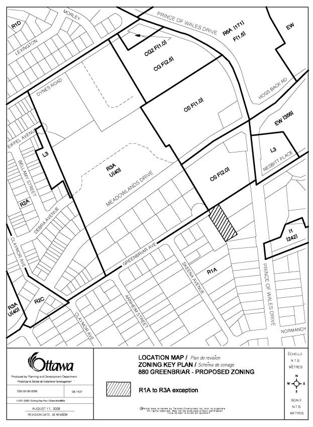
LOCATION MAP Document
1
DETAILS OF RECOMMENDED
ZONING Document
2
The property as shown on Document 1 will be rezoned from R1A to
R3A-exception including the following zone requirement exceptions:
1. despite
subsection 166 (2)(c)ix, the maximum building height is 8.0 metres.
2. despite subsection 177 xvi, a minimum rear yard of 6.0 metres is permitted.
3. despite subsection 177 xx, a minimum interior side yard of 6.0 metres is permitted, except for the rear portion of the lot measuring 25.0 metres deep where a minimum interior side yard of 4.30 metres is permitted.
4.
despite
subsection 177 xix, a minimum interior side yard of 1.20 metres is
permitted.
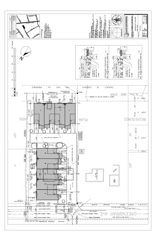
PROPOSED SITE PLAN Document
3
CONSULTATION DETAILS Document
4
Notification and
public consultation was undertaken in accordance with the Public Notification
and Public Consultation Policy approved by City Council for Zoning By-law
amendments.
PUBLIC COMMENTS
There were 36 written responses (including a petition with 79 names) from the public to the notification regarding the initial proposal to develop 11 townhouses that required both a Zoning and Official Plan Amendment. The comments are also in response to the public meeting held on 9 June 2006. The respondent's concerns and staff responses are summarized below.
SUMMARY OF PUBLIC INPUT
1. Comment: We strongly object to the proposed change to the Carleton Heights Secondary Plan from “Residential Area – Low Density” to “Residential Area – Medium Density”. If approved, it would mean a significant change in the character of this part of Carleton Heights, which is at present a cohesive area of single-family homes on relatively large lots.
Response: The Official Plan amendment application submitted concurrently with the Zoning By-law amendment application has been withdrawn by the applicant due to the proposal now being nine-units which can be accommodated under the Residential Area – Low Density designation identified in the Carleton Heights Secondary Plan.
2. Comment: We
object to the proposed change in zoning from R1A –
Detached House Zone to R3A – Converted House/Townhouse Zone, and object
strongly to the requested exceptions to the standard residential regulations,
to pack the townhouses even more closely than normal.
Response: The location of the subject property is ideal for achieving a compatible intensified form of development given its physical context being on the edge of an existing residential neighbourhood and abutting a large community shopping centre (Hogs Back Plaza). The original proposal was for an 11-unit townhouse development comprising of two blocks of six and five units. The applicant has revised the site plan in a manner that is more respectful of the existing context. In this regard the block of five units originally proposed at the rear was reduced to four and oriented in an east/west direction. Having the side of the townhouse face the neighbours rear yards provides an opportunity to plant more vegetation in the six metre wide area surrounding the new buildings thus creating better privacy. The proposed amendment will allow for a built form that is more sensitive to the established area. The policies for more detailed development proposal review will be applied through the Site Plan Control application for the subject site.
3. Comment: Much of the greenspace on the proposed plan will be lost to parking and paving therefore we request that any appropriate measures be taken to minimize the impact of parking and paving of existing greenspace by keeping the existing R1A zoning and not permitting the rezoning. Maintaining the residential area as a low density category will all help preserve much of the existing mature tress presently being destroyed by the proposed plan.
Response: The applicant has been asked to provide a detailed inventory and assessment of the existing trees located on the subject property. It is through the Site Plan Control application process that we will require the retention and preservation of existing specific trees and other vegetation. The City will also require that new trees and fences be provided where needed. For any new developments, typically the building envelope is located in the central area of a property, therefore the periphery of properties is where there are possibilities to retain or enhance the vegetation.
4. Comment: All development proposals seem to require rezoning and then the changes become precedents.
Response: The majority of development proposals in the City do not require zoning changes and those that do are considered on their own merit in the context of the policies set out in the Official Plan.
5. Comment: There should be planning studies done addressing the cumulative impacts of proposals before any rezoning is approved in the area, including the transportation impact on the neighbourhood.
Response: The City’s Official Plan acknowledges and provides direction for secondary planning studies in a number of situations, including along the edge of residential neighbourhoods, and sets out policies to be considered when proposals for zoning amendments are submitted prior to said studies being completed. The subject application has been assessed in the context of the policy framework set out in the Official Plan. Also as noted, a traffic impact assessment for the proposed development has been submitted, and has been reviewed and accepted by staff.
6. Comment: There is presently a shortage of parking spaces on Greenbriar Avenue due to the existing townhouses located on the north side of Greenbriar Avenue. The proposed plan to rezone to R3A will only worsen the current situation.
Response: The proposed development at 880 Greenbriar Avenue will provide for two parking spaces per unit (garage and driveway). Also, although the Zoning By-law does not require visitor parking spaces for the proposed development, the developer will provide two designated visitor parking spaces on the site.
COUNCILLOR’S COMMENTS
Councillor Maria McRae is aware of this application.
COMMUNITY ORGANIZATION COMMENTS
The Carleton Heights and Area Residents
Association (CHARA) held another association meeting on November 15, 2006 regarding the latest
proposal of 9 units at 880 Greenbriar Avenue. They asked that the following motion
be included in the City’s report:
Moved by Roger Tucker, seconded by Michael Mack, that CHARA objects to the
proposed development at 880 Greenbriar Avenue. CARRIED UNANIMOUSLY.