Attachment
|
1. STATUS OF EAST-WEST LIGHT RAIL TRANSIT ENVIRONMENTAL ASSESSMENTS
AND BUS RAPID TRANSIT PRIORITY PROJECTS ÉTAT D’AVANCEMENT DES ÉVALUATIONS ENVIRONNEMENTALES CONCERNANT LE
TRAIN LÉGER SUR RAIL EST-OUEST ET LES PROJETS PRIORITAIRES CONCERNANT LES
SERVICES D’AUTOBUS DIRECTS |
Committee Recommendation as amended
That Council direct staff to include in the 2007 Draft
Capital Budget priority Bus Rapid Transit projects as identified in the Rapid
Transit Expansion Study using the residual North-South Light Rail Transit funds
as identified by the City Treasurer and available senior level government
funding, and that the design of the West Transitway Extension section from
the Southwest Transitway to Pinecrest Road be deferred until Council has
determined the status of converting the Transitway to light rail transit.
Recommandation modifiÉe du comité
Que le Conseil enjoindre le personnel d’inclure
dans les prévisions préliminaires du budget des immobilisations les projets de
transport en commun rapide prioritaires prévus dans l’Étude sur l’expansion du
réseau de transport en commun rapide, en utilisant les fonds non dépensés du
projet du couloir nord-sud du train léger sur rail établis par le trésorier de
la Ville ainsi que les crédits disponibles des paliers de gouvernement
supérieurs, et de reporter la conception de la partie du prolongement du
Transitway Ouest, du Transitway Sud-Ouest au chemin Pinecrest, jusqu’à ce que
le Conseil ait fait le point sur la conversion du Transitway en un réseau de
train léger sur rail.
The Committee tabled Recommendation 1 of the Report until the establishment of the Mayor’s Task Force on Transit and its terms of reference are approved by Council.
Le Comité a déposé la recommandation 1 du rapport
jusqu’à ce que l’établissement du Groupe de travail du maire sur le transport
en commun ainsi que son mandat soient approuvés par le Conseil.
1.
Deputy
City Manager, Planning, Transit and the Environment report dated
12 January 2007 (ACS2007-PTE-POL-0005).
2. Extract
of Draft Minutes, 17 January 2007 will be distributed prior
to Council.
Report to/Rapport au :
Comité des transports en commun
and Council / et au Conseil
12 January 2007 / le 12 janvier 2007
Submitted by/Soumis par : Nancy Schepers, Deputy City Manager /
Directrice municipale adjointe
Contact
Person/Personne ressource : Vivi Chi, Manager, Transportation Infrastructure
Planning
Planning, Environment and Infrastructure
Policy/Politiques d’urbanisme, d’environnement et d’infrastructure
(613) 580-2424 x21722, vivi.chi@ottawa.ca
REPORT RECOMMENDATION
That the Transit Committee recommend
Council:
1. Suspend
the work on the East-West (Orleans-Walkley-Kanata) LRT Environmental Assessment
and defer the initiation of the Carling LRT Environmental Assessment Study,
Rideau-Montreal LRT Environmental Assessment Study, and the Interprovincial
Transit Environmental Assessment Study pending the recommendations of the
Mayor’s Task Force on Transportation;
2. Direct staff to include in the 2007 Draft Capital Budget priority Bus Rapid Transit projects as identified in the Rapid Transit Expansion Study using the residual North-South Light Rail Transit funds as identified by the City Treasurer and available senior level government funding.
RECOMMANDATION DU RAPPORT
Que le Comité du transport en commun recommande au Conseil :
1.
De suspendre l’évaluation
environnementale concernant le couloir est-ouest du train léger sur rail et de
reporter l’étude d’évaluation environnementale des couloirs Carling et
Rideau-Montréal du train léger sur rail ainsi que l’étude d’évaluation
environnementale sur le transport en commun interprovincial, dans l’attente des
recommandations du Groupe de travail du maire sur les transports;
2.
D’enjoindre le personnel d’inclure
dans les prévisions préliminaires du budget des immobilisations les projets de
transport en commun rapide prioritaires prévus dans l’Étude sur l’expansion du
réseau de transport en commun rapide, en utilisant les fonds non dépensés du
projet du couloir nord-sud du train léger sur rail établis par le trésorier de
la Ville ainsi que les crédits disponibles des paliers de gouvernement
supérieurs.
EXECUTIVE SUMMARY
Assumptions and Analysis:
On 25 October 2006, Council put the East-West LRT Study on hold and directed staff to return to Committee in January 2007 with a comprehensive status report on the East-West LRT EA. The purpose of this report is to respond to the Council motion, but in the context of the subsequent decisions to cancel the North-South LRT and the announcement with respect to the formation of the Mayor’s Task Force on Transportation.
The East-West Corridor (Orléans-Walkley-Kanata)
is proposed to serve the greatest concentration of jobs outside the core and is
intended to complement the five existing rapid transit corridors that serve to
connect the suburbs to downtown. Work started on the Environmental Assessment
Study for the E-W corridor in April 2004 and has progressed to the point where
a preliminary preferred alignment was identified. Some concerns were raised by
the public and some Councillors regarding the Study findings. Therefore, it is
recommended that the work on this EA be suspended until the Task Force
completes its review.
It is also recommended that the initiation of other transit Environmental Assessment studies, as identified in the report, be deferred pending the recommendations of the Mayor’s Task Force on Transportation.
Given Council’s decision to cancel the North-South LRT project and in order to guide the 2007 budget deliberations, alternative transit related projects are proposed in this report that would address transportation demand in the short-term.
Financial
Implications:
Approximately $145 million will be required in 2007 to fund the proposed short-term transit projects. Funding details will be provided in the draft capital budget document to be tabled on 7 February 2007.
Public Consultation/Input:
No
consultation was undertaken in the preparation of this report. However,
consultation will be undertaken during the detailed design work for the transit
projects identified for short-term implementation.
RÉSUMÉ
Hypothèses et analyse :
Le 25
octobre 2006, le Conseil mettait de côté l’étude du couloir est-ouest du TLR et
demandait au personnel de présenter de nouveau au comité, en janvier 2007, un
rapport global sur la situation de l’évaluation environnementale de ce couloir.
L’objectif de ce rapport est de répondre à la motion du Conseil, mais dans le
contexte des décisions subséquentes d’annuler l’option du couloir nord-sud et
de l’annonce de la mise sur pied du groupe de travail du maire sur les
transports.
La vocation du couloir est-ouest
(Orléans-Walkley-Kanata) serait de desservir l’endroit réunissant le plus grand
nombre d’emplois en dehors du secteur central et de constituer un complément
aux cinq couloirs de transport en commun rapide actuels qui assurent la
connexion entre la banlieue et le centre‑ville. Les travaux d’évaluation
environnementale du couloir est‑ouest ont commencé en avril 2004 et sont
arrivés à un point où on pouvait proposer un tracé préférentiel préliminaire.
Le public et certains conseillers ont exprimé leurs préoccupations au sujet des
conclusions de l’étude. Par conséquent, on recommande de suspendre les travaux
relatifs à cette ÉE jusqu’à ce que le groupe de travail ait terminé son examen.
On recommande
également de reporter le lancement de toute autre évaluation environnementale
du transport en commun, identifiée dans ce rapport, jusqu’à ce que le groupe de
travail du maire ait déposé ses recommandations.
Compte tenu de la décision du Conseil d’annuler
le projet de développement du couloir nord-sud du TLR et afin d’orienter les
délibérations budgétaires pour l’année 2007, on propose comme solution de
rechange dans ce rapport des projets de transport en commun qui permettraient
de répondre aux besoins à court terme en matière de transport.
Répercussions financières :
Afin
d’assurer le financement des projets de transport à court terme proposés on
aura besoin d’environ 145 millions de dollars. L’ébauche du budget
d’immobilisations attendue pour le 7 février 2007 permettra de prendre
connaissance des détails concernant ce financement.
Consultation publique/Commentaires :
BACKGROUND
On 25 October 2006, Council received an information memo (attached as Document 1) that provided a brief update on the status of specific transportation environmental assessments (EAs) such as the East-West LRT, Rideau-Montreal LRT, Carling LRT and Interprovincial Crossings Study as well as other major transportation EAs currently underway or about to begin. At that time, Council put the East-West LRT Study on hold and directed staff to return to Committee in January 2007 with a comprehensive status report on the East-West LRT EA and the rationale for proceeding with certain corridors while excluding others.
On 14 December 2006, Council cancelled the North-South LRT project and on December 18th requested staff to prepare a memo summarizing the anticipated financial impacts of this decision and to identify the extent of funding available for supporting other transportation related priorities (staff response is attached as Document 3). In addition, staff were requested to provide an overview of the short and longer term transportation infrastructure planning implications of this decision to guide the 2007 budget deliberations (staff response is attached as Document 2). Finally, Mayor O’Brien announced on 11 January 2007 his intent to form a Task Force to study the City’s transportation priorities with final recommendations due by 1 June 2007.
The purpose of this report is to respond to the original motion of Council, passed in October 2006, but to do so in the context of the subsequent decisions on the North-South LRT and the formation of the Task Force. In support of 2007 capital budget deliberations, a number of transit-related capital projects are proposed as short-term opportunities to enhance customer service and serve growth pressures while the longer-term review by the Task Force takes place.
DISCUSSION
Environmental Assessment Status Update
EAST-WEST LRT (ORLÉANS-WALKLEY-KANATA) EA STUDY: STATUS UPDATE
After the downtown, the greatest concentration of jobs outside the core is a band across the southern end of the inner greenbelt area. The band is generally bounded by Hunt Club and Walkley/OCR Railway and includes a variety of industrial, business parks as well as residential communities. These areas are poorly served by transit today. The East-West Corridor (Orléans-Walkley-Kanata) is proposed to serve these areas by providing improved east-west transit connectivity which would help to improve the City’s transit mode split, relieve pressure on the downtown transit corridors and serve as a catalyst for intensification and revitalization of older industrial lands. The corridor also presents a unique opportunity to influence new development within the new growth areas of Kanata and Orléans. This by-pass corridor is intended to complement the five existing corridors that serve to connect the suburbs to the primary destination of downtown. It also connects communities to nodes of employment outside of the core. In other words, the East-West line complements the Transitway network, which is the backbone of the City’s rapid transit system.
Although the Rapid Transit Expansion Study (RTES) identified a later implementation date for this corridor, in 2003 Council deemed it prudent to undertake the Environmental Assessment (EA) for this corridor ahead of time and authorized the commencement of the Environmental Assessment Studies for the corridor in order to identify and protect it in advance of new residential and commercial developments.
In April 2004, Transportation Committee approved the Statement of Work for the Study and in June 2005 Council approved the Terms of Reference, which was subsequently approved by the Ministry of the Environment in September 2005. Up to October 2006, the EA study progressed to the point where a preliminary preferred alignment was identified after much consultation and detailed analyses of many different alignment options. Some of the major options that were examined, but not selected based on the evaluation criteria established through consultation, included the rail corridor, Hydro corridor, the Queensway, and conversion of the Transitway. A summary of these analyses was presented to the public and the information can be found on the City’s website.
Over the course of the public open houses and at Committee several issues have been raised by members of the public and Council regarding the study findings including the following:
· The
corridor runs south of the core area and therefore it does not connect
residents to downtown;
· The corridor is no longer rapid transit since it runs on arterial roads for many sections;
· It is better to convert the existing Transitway to LRT; and
· The corridor should be on the Queensway.
Given these concerns, and despite the risk of losing opportunities to protect properties within the corridor, it is recommended that the work on this EA be suspended until the Task Force on Transportation completes its review.
It should be noted that up to October 2006, $1.8 million has been spent on this EA study and a lot of valuable work has already been completed. The study included the corridor for the extension of the Cumberland Transitway from Navan Road to Innes-Blair intersection. If the Task Force deems it appropriate to use this identified corridor and extend the Transitway to Blair Station to provide a continuous link from Cumberland to downtown, then all that would be required is a scope change to this existing EA to address the short section between Innes-Blair intersection and Blair Station. This would be the most expedient and cost-effective way to complete the planning work for the western portion of Cumberland Transitway (Navan Road to Blair Station) as opposed to starting a completely new study, which would take at least two years to complete. For these reasons and in order to be able to respond to development applications, it is recommended that the EA be suspended and options left open until the Task Force work is complete, rather than prematurely terminating the study at this time.
CARLING LRT EA STUDY: STATUS UPDATE
Carling Avenue is another east-west corridor identified in RTES. It has a relatively wide right-of-way with some transit supportive land use (high rises, employment areas, shopping malls, Lincoln Fields, Carlingwood, Fairlawn plaza, Westgate), entertainment, schools (Woodroffe, Broadview, Nepean, Notre Dame), and connections to other rapid transit lines (O-Train, Southwest Transitway, future East-West LRT Corridor).
This study process was initiated at Council’s direction. A consultant firm has been selected, through a competitive process, however the contract has not been awarded.
Since the Transportation Master Plan (TMP) scheduled this project in the latter part of the planning horizon and since this Study could be affected by the Task Force’s recommendations, it is proposed that this study be deferred pending completion of the Task Force’s mandate.
RIDEAU-MONTREAL LRT EA STUDY: STATUS UPDATE
The original rapid transit network concept described in RTES envisaged the Rideau-Montreal Corridor as an extension to the North-South Corridor LRT line and to connect to the East-West LRT. It was thought of as a complementary project providing connectivity to the rest of the network. In the TMP, this project is also scheduled for the latter part of the planning period.
To respond to Council’s direction to initiate the EA work for this corridor, staff selected a consultant firm, through a competitive process, but the contract has not been awarded.
Since this EA is dependent on the findings of the downtown transit capacity study, discussed later in the report, and the Task Force’s recommendations for other projects (such as the North-South and East-West corridors) it is recommended that this EA be deferred until the work of the Task Force is complete.
It should be noted that since the original RTES concept, redevelopment plans for the 310-acre Rockcliffe Airbase Lands are underway. A draft Community Design Plan (CDP) for the Rockcliffe land development has been proposed by Canada Land Corporation that shows three alternative transit alignments to serve this area. Staff will continue to be involved in the work on the CDP to ensure that options are not precluded for a future extension of transit corridors from downtown.
INTERPROVINCIAL TRANSIT EA STUDY: STATUS UPDATE
The genesis of this study arose from a consideration of the following:
· the impact of existing bus services on the quality of life for residents along Rideau Street and King Edward Avenue;
· the current level of development in the core area; and
· the number of major urban and transportation planning studies already underway in the downtown by the City as well as the NCC and STO (such as LeBreton Flats redevelopment, Sparks Street Mall, Core Area Sector Plan including Chaudière and Victoria Islands, the Rapibus, and the Downtown Urban Design Strategy).
Direction to begin this work came from the National Capital Tripartite Planning Committee and was confirmed by Council.
The purpose of the study is to define a transit system that serves the downtown cores of Ottawa and Gatineau. This system would effectively integrate existing and planned transit services while enhancing the vitality of the two central areas of the Capital Region. The City of Ottawa, the STO, and the NCC are the joint proponents of this EA. The consultant selection process is nearing completion but the contract has not been awarded. The funding agreement with the NCC and STO has not been executed.
This study will be directly affected by longer-term directions that will be considered by the Task Force relating to transit through the core area. In view of this, it is recommended that the study be suspended pending the outcome of other studies.
FUTURE TRANSIT CAPACITY NEEDS AND OPTIONS THROUGH THE DOWNTOWN
The Rapid Transit Implementation Plan adopted in the mid 1970s, recognized the eventual need for a grade-separated Transitway through the downtown. The Plan identified the construction of the grade-separated Transitway corridors outside the Central Area to be the first priorities and recommended delaying the grade separation of the central portion until it became needed.
RTES also confirmed that public transit travel demands could be accommodated by a combination of BRT and LRT operating at street level in the downtown core for the foreseeable future, particularly if some of the demand for non-downtown travel is provided by other by-pass type corridors.
However, continuing ridership growth on the routes which operate through downtown has led to continuing increases in the number of buses using Albert and Slater Streets. Transit service changes and operation adjustments have been implemented to improve service operation. The introduction of Smart Card fare system in 2008 and the installation of improved real-time passenger information system will further improve transit operation by improving customer-boarding time.
As transit demand to and from the downtown continues to grow, it will become increasingly difficult to accommodate all of the transit vehicles in existing bus lanes on Albert and Slater Streets. It was proposed that an EA study be undertaken to address future transit capacity needs and options through the downtown-which may result in the construction of a facility to grade separate all transit vehicles from the general traffic as an ultimate solution. Since vehicle capacity and its implications on the urban environment in the downtown core will be considered by the Mayor’s Task Force, it is recommended that study initiation be deferred until the Task Force completes its review.
2007 DRAFT CAPITAL BUDGET PRIORITY BUS RAPID TRANSIT PROJECTS
Given Council’s decision on 25 October 2006 to put the East-West LRT EA Study on hold as well as its decision on the 14 December 2006 to cancel the North-South LRT project, it became necessary to identify and review current timing and priorities for short-term transit investments that would address pressing transit challenges in order to guide the 2007 budget deliberations.
In Ottawa, the rapid transit network had its genesis during the 1970s, when the former Region of Ottawa-Carleton began a program to implement a bus-based rapid transit (BRT) system. This original program led to the development of a very successful bus rapid transit network. The existing four Transitway corridors (West, Southwest, East, Southeast) carry passengers into and out of the core primarily as a grade-separated system – with the exception through the downtown area. The current Transitway carries about 240,000 trips per day. Ottawa is the city with the highest transit ridership per capita compared to any other North American city of similar size. However, the network as originally planned, was not completed as the funding subsidies from the Province were curtailed in the mid 1990s.
Additional priority bus rapid transit corridors have been identified through the work undertaken by RTES, based on the following key principles:
· A rapid transit service must be based on a network model;
· A network must connect communities to employment opportunities and other major destinations;
· The downtown core will continue its dominance as a major employment destination;
· Expanding network coverage will result in network connectivity and efficiency;
· A network leveraged on the existing bus-based Transitway and complemented by an LRT service in selected corridors will offer the greatest accessibility; and
· The primary service from the suburbs to the downtown must be supplemented by secondary service to connect neighbourhoods and other employment areas to achieve the 30% modal share.
The existing Transitway and future extensions have been designed to serve the primary travel demand from the suburbs to the downtown. While major portions of the Transitway system are already constructed, there are some missing links that could be implemented in the short term to improve transit service for existing riders, attract new riders, and assist in the prevention of increased auto congestion. The proposed projects recognize the Transitway as the backbone of the rapid transit system and recommend the strategic expansion of the Park and Ride system to meet the demand that is exceeding supply, most pressingly in the South and East.
The following is a list of these missing links, which are already identified in RTES and the TMP along with the timing of the authority for these projects as identified in the Long Range Financial Plan III (LRFP 3):
· Cumberland Transitway (Trim Road to Navan) (2008-2009)
· Southwest Transitway (Fallowfield to Chapman Mills) (2007-2009)
· West Transitway (Bayshore to Moodie) (2009-2014)
· West Transitway (Southwest Transitway to Pinecrest) (2014)
Since the planning work for these projects is
in place, it is recommended that the City proceed immediately with the detailed
designs and property purchases, followed by construction as funds become
available.
Other transit-related projects are also identified to support the ridership growth anticipated as a result of implementing the above projects:
· Construction of a new transit garage (2007)
· Construction of new Park-and-Ride lots (2008)
· Purchase of new buses (2007-2010)
· SmartCard Project (2008)
The City Treasurer has identified $100 million in transit-related development charges made available as a result of the cancellation of the North-South Light Rail Transit project, and an additional $12.4 million Infrastructure Grant funding available for other transportation priorities. Staff continue to discuss the eligibility of bus rapid transit and road projects for provincial and federal funding.
Cumberland Transitway (Trim Road to Navan):
Orleans is a rapidly growing urban area with a population of 99,000 today, and is projected to reach 131,000 by 2021. The East Urban Community is currently served by the very successful East Transitway (running along highway 174, served by Route 95 and other express services), and its Orleans Park-and-Ride Lot has been at capacity for years. The City recently opened another lot at Trim Road, with some service extension to Lot for commuters east of Trim Road). For the growing community south of Innes Road, the Cumberland Transitway was identified in the early 1990s. Since that time, corridor protection and planning studies have been completed.
Currently, transit carries 36% of peak hour trips across the Greens Creek Screenline – the highest in the City. This number is forecasted to reach 41% by 2021. To accommodate existing demand and continuing growth in transit ridership, the Cumberland Transitway was identified in the TMP as an interim BRT that could ultimately be converted into light rail as part of the East-West Corridor LRT (Orleans-Walkley-Kanata) project to provide high quality transit access to the southern sector of rapidly growing East Urban Community.
An approved EA already exists for the corridor that extends from Trim Road to Navan Road and design work can start soon. Therefore it is recommended that $10M be allocated in 2007 for design and property purchases with a possible construction start date of 2008.
The section from Navan Road to Innes/Blair Intersection is part of the East-West Corridor LRT EA Study, which will be subject to the Task Force considerations as discussed later in the report.
Southwest Transitway (Fallowfield to Chapman Mills):
The original 31-km Transitway program terminated at Baseline Station with a Park-and-Ride Lot. As south Nepean grew, an extension of the Transitway from Baseline Station to Strandherd Drive was planned in the late 1990s, with implementation dependent on funding availability. Since that time, the City built critical sections (Bus-only lane to Nepean Sportsplex and recently the construction of the Transitway from the Sportsplex to Fallowfield Park-and-Ride Lot, using funding provided by the Federal and Ontario governments through the Millennium Partnership Program).
South Nepean has been growing rapidly over the past few years (currently 55,000) and is expected to grow to over 105,000 in the future. Currently, transit carries about 10% of peak hour trips across Fallowfield Screenline (underestimated since it doesn’t account for riders accessing Fallowfield transit station through the 1000 space park and ride lot). Transit modal split is forecasted to reach 31% by 2021. To accommodate the continuing growth in transit ridership, as evident by the overspill of demand in the Fallowfield Park and Ride lot, transit service has recently opened the Strandherd Park and Ride Lot with interim transit service extension on the road system.
Therefore, it is proposed to extend the existing Southwest Transitway that currently terminates at Fallowfield Station and Park-and-Ride Lot. The corridor would extend on an exclusive right-of-way to the Barrhaven Town Centre to support existing and future growth in South Nepean.
An approved EA already exists to extend the Transitway south to Strandherd and design can start pending budget approval.
It is recommended that $6M be allocated in the 2007 budget for design and property purchases.
West Transitway Extension (Southwest Transitway to Pinecrest, and Bayshore to Moodie):
Kanata/Stittsville is another rapidly growing urban area with a population of 88,000 today, and is projected to reach 186,000 by 2021. Currently, transit carries 18% of peak hour trips across the Eagleson Road screenline. This number is forecasted to reach 38% by 2021. The West Transitway Extension is a key element of transit infrastructure that is required to support existing transit demand as well as projected growth without the need for massive road-building projects.
Transit passengers currently use the West Transitway that extends from Eagleson Road to downtown core. Transit services operate on bus-only shoulder lanes on Highway 417 between Eagleson Road Interchange and Park-and-Ride lot and Moodie Drive Interchange in both directions and between Moodie Drive and Holly Acres in the westbound direction. Buses continue to operate in mixed traffic on Highway 417 to the Queensway Station where it connects with the Southwest Transitway to Lincoln Fields and then beyond to the downtown.
Plans have been completed for a Transitway extension through to Kanata from the Southwest Transitway, with implementation subject to funding availability. Bayshore Station was constructed in 2000, and the section from Pinecrest to Bayshore is in the City’s 2007 work plan with funding coming from a Provincial grant. However, there are still two critical missing links of the West Transitway Extension that, when constructed, will improve reliability of transit service and reduce travel time for transit riders when compared with current bus operation in mixed traffic in the highly congested portion of on Highway 417.
An approved EA already exists for this corridor, which runs along the north edge of Highway 417. The design and construction of the additional two sections would complete the West Transitway Extension from the Southwest Transitway to Moodie.
Design work for these two sections could start soon with a possible construction start date of late 2008. Therefore, it is recommended that $20M be allocated in the 2007 budget for design and property purchases.
New Park & Ride
Lots:
Park and ride lots have been very successful in attracting commuters to transit from the suburbs and rural areas of the City and residents in the communities outside of the City limits. These lots, which are connected to downtown and other major destinations by fast and frequent Transitway service are in high demand and have been demonstrated to attract commuters who would otherwise not consider taking transit.
To support the proposed Cumberland Transitway, the following two lots are also proposed:
· Park-and-Ride lot at Orleans Blvd (in Chapel Hill South)
· Park-and-Ride lot near Trim Road (Millennium Park)
Also, as a result of cancelling the North/South LRT project, and as an interim solution to serve the existing transit demand from Riverside South Community, it is proposed that two new Park and Ride lots be constructed in the south, which would be served by a transit service extension on the road system from South Keys and Fallowfield Stations.
Therefore, it is proposed that $20M be allocated for Park and Ride lots in 2007 budget to start the planning and design works with a possible construction in 2008.
New Buses:
The need for additional buses in the next five years has been increased by the cancellation of the LRT project. The transit network plan that was developed to support the LRT is being revised and the results of this review will be available at the end of January. To support the 2007 budget deliberations, it is estimated that approximately 26 articulated buses will be required for growth in 2008. Since these buses will have to be ordered in 2007 for delivery in 2008, it is proposed that $20.9M be allocated for bus purchases in 2007 budget. Further information on fleet growth will be provided at the 31 January meeting of Transit Committee for Committee’s information.
New Transit Garage:
A new bus garage will be required by 2009 at the latest to accommodate existing and planned fleet acquisitions. Authority is needed in 2007 in order to have the new garage completed by 2009. Funding for this project ($53.3 million) is already included in the LRFP3 in 2007.
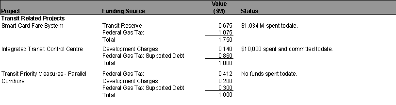
SmartCard Project
In the Fall 2006 Council approved the start of a procurement process for a smartcard fare system. The terms of reference of the system have been developed to the point that an RFP can be released and it is hoped that the system can be in operation by the end of 2008. Key benefits of the smartcard system are: increased transit ridership; reduced fare fraud; and reduce operating costs. The system is expected to cost in the order of $15 million and it is proposed to include this amount in the 2007 budget instead of 2008 as originally shown in the LRFPIII.
CONSULTATION
No consultation was undertaken in the preparation of this report. However, extensive consultation was undertaken during the preparation of RTES, TMP as well as during the EA studies for Cumberland Transitway, Southwest Transitway, West Transitway, as well as the East-West LRT EA. Further consultation will be undertaken during the detailed deign work for the Transitway links identified for short-term implementation.
FINANCIAL IMPLICATIONS
Recommendation 2 of this report will require a request for the following authorities in 2007 budget:
· $10M for the Cumberland Transitway between Trim and Navan (account # 904290) for design and property purchase in 2007;
· $12M for the West Transitway Extension between Southwest Transitway and Pinecrest (account # 903279) for design and property purchase;
· $8M for the West Transitway Extension between Bayshore and Moodie (account # 904294) for design and property purchase;
· $6M for the Southwest Transitway Extension from Fallowfield to Barrhaven Towncentre (account # 903275) for design and property purchase;
· $20M for Park & Ride lots (account # 903278);
· $20.9M for new buses (account # 900874);
· $53.3M for a new transit garage (account # 903780);
· $15M for the SmartCard project (account # 900300).
Funding details will be provided in the draft
capital budget document to be tabled on 7 February 2007.
SUPPORTING DOCUMENTATION
Document 1 Memo from Acting Deputy City Manager, Planning and Growth Management regarding status of major transportation Environmental Assessments (EAs) (11 October 2006)
Document 2 Memo from the Deputy City Manager, Planning Transit and the Environment regarding transportation planning impacts related to Council’s decision not to proceed with the North-South Light Rail Transit (22 December 2006)
Document 3 Memo from the City Treasurer regarding impact of cancellation of the North/South Light Rail project (21 December 2006)
DISPOSITION
Upon receipt of Council approval, staff will include the transit projects identified for short-term implementation in 2007 budget.
MEMO FROM DEPUTY
CITY MANAGER, PLANNING AND
GROWTH MANAGEMENT (11 OCTOBER 2006) DOCUMENT 1
|
To / Destinataire |
Chair and Members of Transportation Committee
/ Président et Membres du Comité des transports |
File/N° de
fichier: ACS2006-PGM-POL-0081 |
|
From
/ Expéditeur |
John L. Moser Acting Deputy City Manager Planning and Growth Management / Directeur
municipal adjoint par intérim Urbanisme et Gestion de la croissance |
|
|
Subject
/ Objet |
Status of Major Transportation Environmental
Assessments (EAs) / État des études environnementale importante en
matière de transport |
Date : 11 October
2006 le 11
octobre 2006 |
On 04 October 2006, several inquires were made at the Transportation Committee meeting regarding the status of specific EAs such as the East-West LRT, Rideau-Montréal LRT, Carling LRT and Interprovincial Bridges Study. Further to direction given by the Transportation Committee, this memo also provides a brief update on the status of other major transportation EAs currently underway or about to begin this year.
A more
comprehensive status report on the East-West LRT EA (detailing the technical
findings to date, public comments and study team responses etc.) will be
prepared and presented to Transportation Committee in early 2007. Pending feedback from Committee on the work
done to date by staff and the project consultants, and further consultation
with the public and other government agencies, the study’s final
recommendations could be ready for presentation to Committee by mid 2007.
East-West LRT EA
Council and Transportation
Committee Decisions To Date
Study Activities Undertaken
Carling Corridor LRT EA and Rideau-Montreal
Corridor LRT EA:
These independent
projects make up the two remaining east-west LRT links in the Council-approved
transportation network. They will
connect to other corridors (including the East-West LRT project) to provide
access options and flexibility for transit users. After all three east-west studies are completed, Council will
decide on the implementation priority for each project.
Committee
approved the Statements of Work for Carling and Rideau-Montréal studies in May
2006. Consultant teams have just been
selected. Terms of References will be
prepared for each, with presentations to Committee and Council approval by
Spring 2007.
North-South LRT EA
(University of Ottawa to Barrhaven Town Centre):
Federal and
Provincial EA approval has been received for the original EA (Rideau Centre to
Barrhaven Town Centre). An Addendum to
the EA has been completed for the extension to the University and to allow car
traffic back onto MacKenzie King Bridge.
A report on the Addendum will be presented to Transportation Committee
on 18 October 2006.
Interprovincial Transit
Integration (Core Area) EA:
Consultant proposals
are currently being evaluated and it is expected that the study can get
underway before year-end. The Terms of
Reference will be presented to Committee and Council for approval by mid
2007. A change in project management
(previously National Capital Commission were to lead) now has this study being
jointly chaired between the City of Ottawa and STO, with 1/3 funding contribution
from the NCC. Committee approved the
Statement of Work in October 2004.
Interprovincial Crossings
EA:
The NCC
is leading this study, with equal funding contributions from the MTO and
MTQ. The NCC presented the study’s
Statement of Work to Committee in November 2005. A consultant team has been selected and contract award is
awaiting Treasury Board approval. The
City has representation on the study’s Steering Committee as well as the Core
Study Team. Consultation and
communication of study progress will be a major effort for the NCC and its
provincial partners. The Terms of
Reference will be presented to Committee in 2007.
Innes-Walkley Link EA and Hunt Club Extension EA:
Several meetings and
open houses have been held with the general public and government
agencies. Refinements to the alignment
are taking place with on-going discussions with the NCC and the MTO. This work can wrap up in 2007. One final open house will be held before
presenting the study recommendations to Committee and Council.
A final open house is
scheduled for late 2006. Presentation
of the study recommendations to Committee and Council will be in March/April
2007.
A final open house is scheduled for late 2006. Presentation of the study recommendations to
Committee and Council will be in March/April 2007.
Jockvale Road Widening EA (Rideau River to Prince of Wales)
The
Statement of Work will be presented to Committee on 18 October 2006.
John L. Moser
MEMO
FROM DEPUTY CITY MANAGER, PLANNING,
TRANSIT AND THE ENVIRONMENT (22 DECEMBER 2006) DOCUMENT 2
|
To / Destinataire |
Mayor and Members of Council |
File/N° de
fichier: |
|
From
/ Expéditeur |
Nancy Schepers Deputy City Manager Planning, Transit and the Environment
Department |
|
|
Subject / Objet |
Transportation Planning
Impacts related to Council’s decision not to proceed with the North-South
Light Rail Transit project |
Date : December 22,
2006 |
At the Council meeting of Monday, December 18th, staff advised that they would report on the financial impacts to the Long Range Financial Plan III and the 2007 Operating and Capital Budget related to Council’s decision not to pursue the North-South Light Rail Transit project.
The City Treasurer’s companion memo provides details on the financial impacts and opportunities of Council’s decision. This memo will outline long-term transportation planning implications, medium-term infrastructure improvements as they relate to the 2007 Budget process, and recommended 2007 Operating and Capital transit projects.
The decision not to proceed with the North-South Light Rail Transit project requires Council to revisit and confirm the transportation vision as articulated in the Official Plan and Transportation Master Plan. This will require a reassessment of short and long-term transit priorities advanced in both the Rapid Transit Expansion Study (RTES) and Ottawa Rapid Transit Expansion Program (ORTEP). This direction will then be used to refresh the 2008 Official Plan, 2008 Transportation Master Plan, and amend any necessary Community Design Plans.
At this time, Staff have been advised that it is the Mayor’s intention to strike a Task Force who will review and make recommendations in May 2007 on the City’s overall transportation priorities. Considerations could include:
The decision not to proceed with the North-South Light Rail Transit project requires the introduction of alternative projects to address transportation demand, particularly in the southern part of the City. Priority Transportation Master Plan transit and road projects in the southern area of the City have been listed below along with priority East-West Bus Rapid Transit projects. The timing of the authority for these projects as identified Long Range Financial Plan III is as shown below. In addition, other infrastructure projects which were tied to the North-South Light Rail Transit project have been listed. Given the removal of North-South Light Rail Transit, staff intends to review the overall relative priorities of these projects and make recommendations as part of the 2007 Capital Budget submission using the fiscal capacity identified by the City Treasurer.
Transit projects:
(2008-2009)
Road projects:
Other Infrastructure projects:
The 2010 transit network plan was developed on the premise that buses and light rail vehicles would share the same lanes on Albert and Slater Streets. Now that this will not be the case in that time period, a detailed review of the hub and spoke network is underway to determine which changes to transit are required to create strategic networks that will improve service and increase ridership. Recommended changes will be brought forward through Budget 2007. In addition staff will be considering additional short-term North-South transit measures to address immediate needs, for example a Park and Ride facility in the Southeast.
Should you require further information on the above, please do not hesitate to contact me.
All the best for the holiday season,
Original signed by:
NS./ CC
cc: Kent
Kirkpatrick, City Manager
Members of Executive Management Committee
MEMO FROM CITY TREASURER (DECEMBER 21, 2006) DOCUMENT 3
|
To / Destinataire |
Mayor and Members of Council |
File/N° de
fichier: |
|
From / Expéditeur |
Marian Simulik Director, Financial Services |
|
|
Subject / Objet |
Impact of Cancellation of the North/South
Light Rail Project |
Date : December 21 2006 |
At the Council meeting of December 18, 2006, a request was made to identify the financial impact of the cancellation of the North//South Light Rail Project. Attached is a list of capital projects that were approved in 2006 that either formed part of the base LRT project or were being advanced in order to coordinate with the LRT work. The spending to date of each project has also been identified.
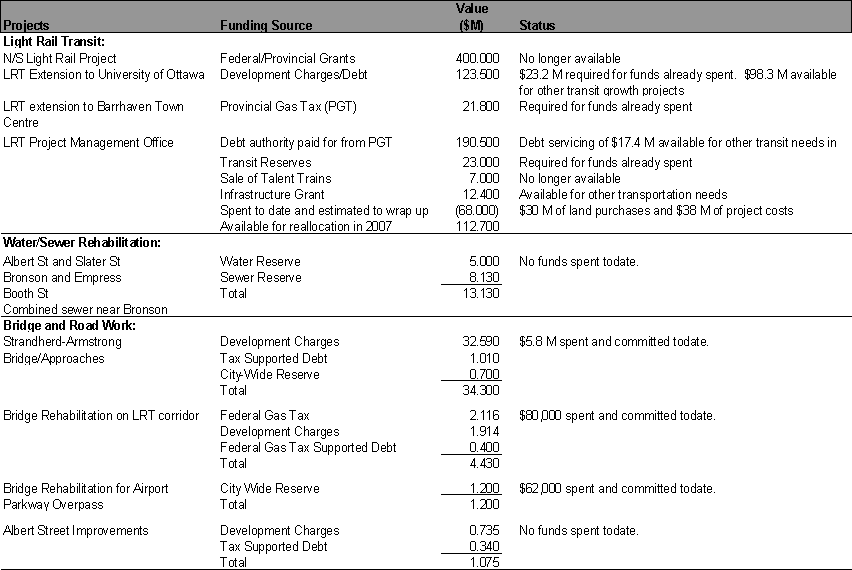
As you will see from the chart, the funds spent to date on the LRT project plus those estimated to project wrap-up are now projected to be $68 million. This leaves approximately $100 million of development charge funding available to be reallocated to other transit growth capital works and $12.4 million of Infrastructure Grant funding available for other transportation priorities. The $17.4 million in provincial gas tax that would have been used to service the authorized debt for the LRT project was already being used in the 2007 transit capital program as the debt servicing was not to start until 2008.
The future status of the water and sewer rehabilitation projects, bridge and road projects and transit related projects will be identified in a memo from the Deputy City Manager of Planning, Transit and Environment.
In terms of impacts on the 2007 operating budget, $2 million in additional costs related to the LRT were identified which included the savings associated with the discontinuance of the O-Train in April and the introduction of the hub and spoke model of bus service. The hub and spoke service model is under review. Based on continued O-Train service in 2007 and the implementation of the revised hub and spoke model, the additional funding pressure for 2007 has been reduced to $800,000. This reduces the 2007 corporate list of pressures by $1.2 million - from $95.4 million to $94.2 million.
If you have any further questions please contact either myself at 14159 or Tom Fedec at 21316.
Marian Simulik
Attach.
Attachment
Report to/Rapport au :
Transit Committee
Comité des transports en commun
and Council / et au Conseil
12 January 2007 / le 12 janvier 2007
Submitted by/Soumis par : Nancy Schepers, Deputy City Manager /
Directrice municipale adjointe
Contact Person/Personne ressource : Vivi Chi,
Manager, Transportation Infrastructure Planning
Planning, Environment and Infrastructure
Policy/Politiques d’urbanisme, d’environnement et d’infrastructure
(613) 580-2424 x21722, vivi.chi@ottawa.ca
|
Réf. N°:
ACS2007-PTE-POL-0005 |
|
OBJET : |
État d’avancement des évaluations
environnementales concernant le train léger sur rail est-ouest et les projets
de transport en commun rapide prioritaires |
|
|
|
|
SUBJECT: |
STATUS
OF EAST-WEST ENVIRONMENTAL ASSESSMENT AND BUS RAPID TRANSIT PRIORITY PROJECTS |
RECOMMANDATION DU RAPPORT
Que le Comité du transport en commun recommande au Conseil :
3.
De suspendre l’évaluation
environnementale concernant le couloir est-ouest du train léger sur rail et de
reporter l’étude d’évaluation environnementale des couloirs Carling et
Rideau-Montréal du train léger sur rail ainsi que l’étude d’évaluation
environnementale sur le transport en commun interprovincial, dans l’attente des
recommandations du Groupe de travail du maire sur les transports;
4.
D’enjoindre le personnel d’inclure
dans les prévisions préliminaires du budget des immobilisations les projets de
transport en commun rapide prioritaires prévus dans l’Étude sur l’expansion du
réseau de transport en commun rapide, en utilisant les fonds non dépensés du
projet du couloir nord-sud du train léger sur rail établis par le trésorier de
la Ville ainsi que les crédits disponibles des paliers de gouvernement
supérieurs.
REPORT RECOMMENDATION
That the Transit
Committee recommend Council:
1. Suspend
the work on the East-West (Orleans-Walkley-Kanata) LRT Environmental Assessment
and defer the initiation of the Carling LRT Environmental Assessment Study,
Rideau-Montreal LRT Environmental Assessment Study, and the Interprovincial
Transit Environmental Assessment Study pending the recommendations of the
Mayor’s Task Force on Transportation;
2. Direct staff to include in the 2007 Draft Capital Budget priority Bus Rapid Transit projects as identified in the Rapid Transit Expansion Study using the residual North-South Light Rail Transit funds as identified by the City Treasurer and available senior level government funding.
RÉSUMÉ
Hypothèses et analyse :
Le 25
octobre 2006, le Conseil mettait de côté l’étude du couloir est-ouest du TLR et
demandait au personnel de présenter de nouveau au comité, en janvier 2007, un
rapport global sur la situation de l’évaluation environnementale de ce couloir.
L’objectif de ce rapport est de répondre à la motion du Conseil, mais dans le
contexte des décisions subséquentes d’annuler l’option du couloir nord-sud et
de l’annonce de la mise sur pied du groupe de travail du maire sur les
transports.
La vocation du couloir est-ouest
(Orléans-Walkley-Kanata) serait de desservir l’endroit réunissant le plus grand
nombre d’emplois en dehors du secteur central et de constituer un complément
aux cinq couloirs de transport en commun rapide actuels qui assurent la
connexion entre la banlieue et le centre‑ville. Les travaux d’évaluation
environnementale du couloir est‑ouest ont commencé en avril 2004 et sont
arrivés à un point où on pouvait proposer un tracé préférentiel préliminaire.
Le public et certains conseillers ont exprimé leurs préoccupations au sujet des
conclusions de l’étude. Par conséquent, on recommande de suspendre les travaux
relatifs à cette ÉE jusqu’à ce que le groupe de travail ait terminé son examen.
On
recommande également de reporter le lancement de toute autre évaluation
environnementale du transport en commun, identifiée dans ce rapport, jusqu’à ce
que le groupe de travail du maire ait déposé ses recommandations.
Compte tenu de la décision du Conseil d’annuler
le projet de développement du couloir nord-sud du TLR et afin d’orienter les
délibérations budgétaires pour l’année 2007, on propose comme solution de
rechange dans ce rapport des projets de transport en commun qui permettraient
de répondre aux besoins à court terme en matière de transport.
Répercussions financières :
Afin
d’assurer le financement des projets de transport à court terme proposés on
aura besoin d’environ 145 millions de dollars. L’ébauche du budget
d’immobilisations attendue pour le 7 février 2007 permettra de prendre
connaissance des détails concernant ce financement.
Consultation publique/Commentaires :
EXECUTIVE SUMMARY
Assumptions and Analysis:
On 25 October 2006, Council put the East-West LRT Study on hold and directed staff to return to Committee in January 2007 with a comprehensive status report on the East-West LRT EA. The purpose of this report is to respond to the Council motion, but in the context of the subsequent decisions to cancel the North-South LRT and the announcement with respect to the formation of the Mayor’s Task Force on Transportation.
The East-West Corridor (Orléans-Walkley-Kanata)
is proposed to serve the greatest concentration of jobs outside the core and is
intended to complement the five existing rapid transit corridors that serve to
connect the suburbs to downtown. Work started on the Environmental Assessment
Study for the E-W corridor in April 2004 and has progressed to the point where
a preliminary preferred alignment was identified. Some concerns were raised by
the public and some Councillors regarding the Study findings. Therefore, it is
recommended that the work on this EA be suspended until the Task Force
completes its review.
It is also recommended that the initiation of other transit Environmental Assessment studies, as identified in the report, be deferred pending the recommendations of the Mayor’s Task Force on Transportation.
Given Council’s decision to cancel the North-South LRT project and in order to guide the 2007 budget deliberations, alternative transit related projects are proposed in this report that would address transportation demand in the short-term.
Financial
Implications:
Approximately $145 million will be required in 2007 to fund the proposed short-term transit projects. Funding details will be provided in the draft capital budget document to be tabled on 7 February 2007.
Public
Consultation/Input:
No consultation
was undertaken in the preparation of this report. However, consultation will be
undertaken during the detailed design work for the transit projects identified
for short-term implementation.
Le 25 octobre 2006, le Conseil était saisi d’un
note d’information (ci‑jointe comme Document 1) présentant une brève mise
à jour du statut d’avancement de certaines évaluations environnementales (ÉE)
de projets de transport comme le couloir est‑ouest du TLR, le couloir
Rideau‑Montréal, le couloir Carling et l’étude sur le transport en commun
interprovincial, ainsi que d’autres ÉE majeures de transport en cours ou sur le
point de commencer. C’est à ce moment‑là que le Conseil mettait de côté
l’étude du couloir est-ouest du TLR et demandait au personnel de présenter de
nouveau au comité, en janvier 2007, un rapport global sur la situation de
l’évaluation environnementale de ce couloir ainsi qu’une justification pour
poursuivre les travaux dans certains couloirs et en exclure d’autres.
Le 14 décembre 2006, le Conseil annulait le
projet de couloir nord-sud et demandait, le 18 décembre, au personnel de
préparer une note d’information sur les répercussions financières probables de
cette décision et de déterminer quel était le budget disponible pour soutenir
les autres priorités en matière de transport (la réponse du personnel est
jointe comme Document 3). On demandait
en outre au personnel de présenter un aperçu des répercussions à court et à
long terme de cette décision sur la planification de l’infrastructure des
transports afin d’orienter les délibérations budgétaires pour l’année 2007 (la
réponse du personnel est jointe comme Document 2). Enfin, le maire O’Brien
annonçait le 11 janvier 2007 son intention de créer un groupe de travail dont
le mandat serait d’étudier les priorités de la Ville en matière de transport et
de présenter des recommandations finales d’ici le 1er juin 2007.
L’objectif de ce rapport est de répondre à la
motion originale du Conseil d’octobre 2006, mais dans le contexte des décisions
subséquentes concernant le couloir nord-sud du TLR et la mise sur pied du
groupe de travail du maire. Dans le cadre des délibérations relatives au budget
des immobilisations de 2007, on propose un certain nombre de projets
d’immobilisations liés au transport en commun comme moyens d’améliorer à court
terme le service à la clientèle et de répondre aux pressions relatives à la
croissance pendant l’examen à plus long terme du groupe de travail.
DISCUSSION
Mise à jour sur l’évaluation environnementale
ÉE DU COULOIR EST‑OUEST DU TLR
(ORLÉANS-WALKLEY-KANATA) : MISE À JOUR
Après le centre‑ville,
la plus forte concentration d’emplois en dehors du secteur central se trouve
dans une bande du secteur sud à l’intérieur de la ceinture de verdure. De façon
générale, cette bande est délimitée par le chemin Hunt Club et le chemin
Walkley/CFCO et compte toute une variété de parcs industriels et commerciaux, ainsi
que des communautés résidentielles. Ces secteurs sont actuellement mal
desservis par le transport en commun. Le couloir est‑ouest proposé
(Orléans-Walkley-Kanata) permettrait de les desservir en améliorant la
connectivité est‑ouest du réseau de transport en commun, ce qui aurait
pour effet d’améliorer la répartition modale, d’alléger les pressions sur les
couloirs de transport du centre‑ville et d’agir comme catalyseur pour
intensifier l’activité et revitaliser les plus vieux terrains industriels. Ce
couloir constituerait également une occasion unique d’influencer la croissance
de nouveaux développements dans les secteurs en croissance de Kanata et
d’Orléans. La rocade aurait pour but de compléter les cinq couloirs actuels de
jonction entre la banlieue et la destination primaire du centre‑ville.
Elle permettrait également de relier les collectivités aux pôles d’emploi en
dehors du secteur central. Autrement dit, le couloir est‑ouest complète
le réseau du Transitway, épine dorsale du système de transport en commun rapide
de la ville.
Bien que l’étude sur l’expansion du réseau de
transport en commun rapide (ÉERTCR) reporte à une date ultérieure la
construction de ce couloir, le Conseil a jugé prudent, en 2003, de lancer une
évaluation environnementale (ÉE) à ce sujet, bien avant même le lancement du
projet, et autorisé des évaluations environnementales du couloir dans le but de
le délimiter et de le protéger par avance de nouveaux développements
résidentiels ou commerciaux.
En avril 2004, le Comité des transports a
approuvé l’énoncé de travail de l’étude et, en juin 2005, le Conseil ratifiait
le mandat, que,le ministère de l’Environnement approuvait à son tour en
septembre 2005. Jusqu’à octobre 2006, l’ÉE a progressé à un point tel qu’il
devenait possible de recommander un tracé préliminaire préférentiel, après
moultes consultations et analyses détaillées d’un bon nombre d’options
différentes. Parmi les grandes options qui ont été examinées, mais non retenues
étant donné les critères d’évaluation établis dans le cadre des consultations,
figuraient le couloir ferroviaire, le corridor de transport de l’électricité,
le Queensway, et la conversion du Transitway. Un sommaire de ces analyses a été
présenté au public; on trouvera l’information sur le site Web de la Ville.
Lors des réunions publiques et des
délibérations du comité, le public et le Conseil ont soulevé plusieurs questions
au sujet des conclusions des études, dont les suivantes :
· Le couloir passe au sud du secteur
central et ne permet par conséquent pas aux résidents d’aller au centre‑ville;
· Le
couloir n’est plus un axe de transport rapide puisque de nombreuses sections
empruntent des artères;
· Il
vaudrait mieux convertir le Transitway actuel en réseau de TLR; et
· Ce
couloir devrait emprunter le Queensway.
Compte tenu de ces préoccupations, et en dépit
du risque de perdre des occasions de protéger les propriétés situées dans le
couloir, on recommande de suspendre cette évaluation environnementale jusqu’à
ce que le groupe de travail sur les transports ait terminé ses travaux.
Il convient de remarquer que, jusqu’à octobre
2006, 1,8 million de dollars a été dépensé pour cette évaluation
environnementale et que l’on a déjà abattu un travail inestimable. L’étude
comprenait le couloir de prolongement du Transitway de Cumberland du chemin
Navan à l’intersection des chemins Innes‑Blair. Si le groupe de travail
jugeait approprié d’utiliser le couloir identifié et de prolonger le Transitway
jusqu’à la station Blair afin d’assurer un lien continu entre Cumberland et le
centre‑ville, il suffirait alors de modifier la portée de l’ÉE actuelle
et de n’examiner que la petite portion comprise entre l’intersection Innes‑Blair
et la station Blair. Ce serait la façon la plus expéditive et la plus rentable
de terminer le travail de planification de la portion ouest du Transitway de
Cumberland (Chemin Navan à la station Blair), au lieu de faire une toute
nouvelle étude qui prendrait au moins deux ans. Étant donné ces raisons, et
pour répondre aux demandes de développement, on recommande que l’ÉE soit
suspendue et que l’on garde les options ouvertes jusqu’à ce que le groupe de
travail ait terminé ses travaux, plutôt que de mettre prématurément un terme à
l’étude dès maintenant.
ÉE DU COULOIR CARLING DU TLR : MISE À JOUR
L’avenue Carling est l’un des couloirs
est-ouest retenus dans le cadre de l’étude sur l’expansion du réseau de transport
en commun rapide (ÉERTCR). L’emprise est relativement large et comporte des
terrains propices au transport en commun (immeubles, secteurs d’emploi, centres
commerciaux, Lincoln Fields, Carlingwood, Fairlawn, Westgate), des centres de
loisirs, des écoles (Woodroffe, Broadview, Nepean, Notre Dame), et des
correspondances vers d’autres lignes de transport rapide (O-Train, Transitway
Sud‑Ouest, futur couloir est‑ouest du TLR).
C’est le Conseil qui a demandé que l’on
entreprenne cette étude. On a sélectionné une firme de consultants par voie de
concours, sans pour autant signer de contrat.
Étant donné que, selon le Plan directeur des
transports (PDT), ce projet est prévu pour la fin de l’horizon de planification
et que l’étude pourrait être affectée par les recommandations du groupe de
travail, on propose de la différer jusqu’à la fin du mandat.
ÉE DU COULOIR RIDEAU-MONTREAL DU TLR :
MISE À JOUR
Selon le concept original du réseau de
transport en commun rapide décrit dans l’ÉERTCR, on prévoyait la construction
d’un couloir Rideau-Montréal en prolongement du couloir nord‑sud du TLR
et d’assurer la connexion avec le couloir est‑ouest du TLR. On pensait
que ce projet serait un complément permettant d’assurer la liaison avec le
reste du réseau. Dans le PDT, ce projet est lui aussi prévu pour la fin de la
période de planification.
En réponse à la demande du Conseil de lancer
les travaux d’ÉE de ce couloir, le personnel a sélectionné une firme de
consultants par voie de concours, mais le contrat n’a toujours pas été signé.
Étant donné que cette ÉE dépend des conclusions
de l’étude sur la capacité du transport en commun rapide vers le centre‑ville,
dont nous parlons plus loin dans ce rapport, et compte tenu des recommandations
du groupe de travail relativement à d’autres projets (p. ex., les couloirs
nord‑sud et est‑ouest), on recommande de suspendre cette ÉE jusqu’à
ce que le groupe de travail ait terminé ses travaux.
Il convient de remarquer que depuis le début de
l’ÉERTCR les plans de redéveloppement des 310 acres de terrain de la base
aérienne de Rockcliffe sont en cours. La Canada Land Corporation a proposé une
ébauche de plan de conception communautaire (PCC) pour le développement de ces
terrains avec trois possibilités de tracé pour desservir ce secteur. Le
personnel participe toujours aux travaux sur le PCC dans le but de s’assurer
qu’on n’écarte pas d’options lors d’un futur prolongement des couloirs de
transport en commun en provenance du centre‑ville.
ÉE DU TRANSPORT INTERPROVICIAL : MISE À
JOUR
La genèse de cette étude découle des
préoccupations ci‑dessous :
· Impact
des services d’autobus actuels sur la qualité de vie des résidents de la rue
Rideau et de l’avenue King Edward;
· Niveau
actuel du développement dans le secteur central;
· Nombre
des grandes études de planification urbaine et des transports de la Ville déjà
en cours sur le centre‑ville, ainsi que de la CCN et du STO
(redéveloppement des plaines Lebreton, mail de la rue Sparks, planification du
secteur central avec les îles Chaudière et Victoria, Rapibus, et stratégie
de conception urbaine du centre-ville).
La consigne de commencer ces travaux est venue
du comité tripartite de planification de la Capitale nationale et a été
entérinée par le Conseil.
L’objet de cette étude est de concevoir un
système de transport en commun qui desserve le centre‑ville d’Ottawa et
celui de Gatineau. Ce système assurerait une intégration efficace des services
de transport en commun actuels et à venir tout en rehaussant la vitalité des
deux secteurs centraux de la région de la capitale. La Ville d’Ottawa, le STO
et la CCN ont proposé conjointement de faire cette évaluation environnementale.
Le processus de sélection des consultants est en voie de se terminer, mais
aucun contrat n’a encore été adjugé. L’entente de financement entre la CCN et
le STO n’a pas été appliquée.
Cette étude sera directement affectée par
l’orientation à long terme que préconisera le groupe de travail sur le
transport en commun au sujet du secteur central. Pour cette raison, on recommande
de suspendre cette évaluation en attendant le résultat d’autres études.
BESOINS FUTURS DE CAPACITÉ DU TRANSPORT EN
COMMUN ET OPTIONS POUR LE CENTRE‑VILLE
Dans le Plan du transport en commun rapide adopté au milieu des années 70, on
parlait du besoin de construire un Transitway sur plusieurs niveaux vers le
centre‑ville. Le plan prévoyait la construction de couloirs pour le
Transitway à des niveaux différents en dehors du secteur central, ce qui serait
la première priorité, et on recommandait de surseoir à la construction de
niveaux distincts dans la partie centrale tant qu’on n’en aurait pas besoin.
Dans l’ÉERTCR, on affirmait également qu’il
serait possible de répondre à la demande du public en matière de transport en
commun en exploitant concurremment le TRA et le TLR au niveau de la rue dans le
secteur central pour l’avenir prévisible, en particulier si la demande de
transport autre qu’en direction du centre‑ville était satisfaite par
d’autres couloirs de type rocade.
Cependant, la croissance permanente du nombre
de passagers sur les circuits qui passent par le centre‑ville a entraîné
la nécessité de faire circuler de plus en plus d’autobus sur les rues Albert et
Slater. On a fait, et mis en place, un certain nombre de modifications du
transport en commun afin d’améliorer le service. L’introduction, en 2008, du
système de collecte des tarifs par carte à puce et la mise en place d’un
meilleur système d’information en temps réel des passagers permettront
d’améliorer encore les opérations de transport en accélérant le temps
d’embarquement de la clientèle.
La demande de services de transport en commun
pour le centre‑ville dans les deux sens continuant à augmenter, il va
devenir de plus en plus difficile de faire circuler tous les véhicules sur les
voies réservées aux autobus des rues Albert et Slater. On a proposé de faire
une ÉE des futurs besoins en matière de capacité et des options dans le centre‑ville,
ce qui pourrait aboutir, comme recours ultime, à la construction d’un niveau
distinct pour tous les véhicules assurant le trafic général du transport en
commun. La capacité en véhicules et les répercussions sur l’environnement du
centre‑ville devant être étudiées par le groupe de travail, on recommande
que le lancement de cette étude soit reporté à la fin des travaux de ce groupe.
ÉBAUCHE DE BUDGET DES IMMOBILISATIONS DE
2007 – PROJETS PRIORITAIRES EN MATIÈRE DE TRANSPORT EN COMMUN RAPIDE
Compte tenu de la décision du Conseil du 25
octobre 2006 de suspendre l’ÉE du couloir est‑ouest du TLR, ainsi que de
sa décision du 14 décembre 2006 d’annuler le projet de couloir nord‑sud
du TLR, il est devenu nécessaire de préciser et de revoir l’échéancier actuel
et les priorités d’investissement à court terme dans le transport en commun
pour répondre aux défis pressants et orienter les délibérations au sujet du
budget de l’année 2007.
À Ottawa,
le réseau de transport en commun rapide a vu le jour dans les années 70, quand
l’ancienne région d’Ottawa‑Carleton a décidé de lancer un programme de
mise en œuvre d’un système de transport en commun rapide par autobus (TRA). Le
programme original a permis la mise sur pied, avec beaucoup de succès, d’un
réseau de transport en commun rapide par autobus. Les quatre couloirs actuels
du Transitway (Ouest, Sud‑Ouest, Est, Sud‑Est) permettent de
transporter les passagers vers le secteur central et de revenir en empruntant
des niveaux séparés, à l’exception du secteur du centre‑ville. Le
Transitway, dans sa forme actuelle, assure quelque 240 000 déplacements
par jour, faisant d’Ottawa la ville avec le plus grand nombre de déplacements
par habitant de toutes les villes d’Amérique du Nord de taille similaire.
Cependant, ce réseau, tel qu’il avait été planifié au départ, n’a pas été
terminé en raison de la suspension des subventions provinciales au milieu des
années 90.
Les travaux entrepris dans le cadre de l’ÉERTCR
ont permis de définir d’autres couloirs prioritaires de transport en commun
rapide par autobus selon les principes suivants :
· Tout
service de transport en commun rapide doit reposer sur un modèle de réseau;
· Le
réseau doit permettre de relier les collectivités aux secteurs où se trouvent
les emplois et aux autres grandes destinations;
· Le
secteur central doit garder sa prédominance comme principale destination;
· Plus
le réseau sera étendu, meilleur il sera du point de vue de la connectivité et
de l’efficience;
· Un
réseau s’appuyant sur le Transitway pour les autobus et complété par un service
de TLR dans certains couloirs offrirait une accessibilité optimale; et
· Le
service primaire à partir des banlieues vers le centre‑ville doit être
complété par un service secondaire permettant de relier les quartiers et les
secteurs d’emploi dans une répartition modale de 30 %.
Le tracé actuel du Transitway et ses
prolongements futurs ont été conçus pour répondre à la demande primaire de
déplacement des gens de la banlieue vers le centre‑ville. Bien que de
grandes portions du système de Transitway soient déjà construites, il manque
encore quelques liens qui pourraient être mis en place à court terme afin
d’améliorer le service offert à la clientèle actuelle, d’attirer de nouveaux
passagers, et de prévenir l’augmentation de la congestion automobile. Les
projets proposés tiennent compte du fait que le Transitway constitue l’épine
dorsale du système de transport en commun rapide et on y recommande une
extension stratégique du système des parcs‑o‑bus afin d’accommoder
la demande qui dépasse l’offre, surtout dans le Sud et l’Est.
On présente ci‑dessous la liste de ces
liens manquants, déjà relevés dans l’ÉERTCR et le PDT, ainsi que l’échéancier
de ces projets dans le Plan financier à long terme III (PFLT 3):
· Transitway
de Cumberland (Chemin Trim à Navan) (2008-2009)
· Transitway
Sud‑Ouest (Fallowfield à Chapman Mills) (2007-2009)
· Transitway
Ouest (Bayshore à Moodie) (2009-2014)
· Transitway
Ouest (Transitway Sud‑Ouest à Pinecrest) (2014)
Étant donné que les travaux de planification de
ces projets sont en cours, on recommande que la Ville aille immédiatement de
l’avant avec les conceptions détaillées et les achats de terrain, pour ensuite
entamer les travaux de construction quand les fonds seront disponibles.
Autres projets liés au transport en commun pour
soutenir la croissance prévue de l’achalandage par suite de la mise en œuvre
des projets ci‑dessus :
· Construction
d’un nouveau garage pour le transport en commun (2007)
· Construction
de nouveaux parcs‑o‑bus (2008)
· Achat
de nouveaux autobus (2007-2010)
· Projet
de carte à puce (2008)
Le trésorier de la Ville a isolé 100 millions de
dollars pour le développement du transport en commun qui seraient disponibles
par suite de l’annulation du projet de couloir nord‑sud du TLR, plus 12,4
autres millions de financement des infrastructures pour d’autres priorités en
matière de transport. Le personnel est toujours en discussion afin d’établir
l’admissibilité des projets de route et de transport au financement provincial
et fédéral.
Transitway de Cumberland (Chemin Trim à
Navan) :
Orléans est une zone urbaine en croissance
rapide dont la population, forte aujourd’hui de 99 000 habitants, pourrait
grimper à 131 000 d’ici 2021. La communauté urbaine de l’Est est
actuellement desservie avec beaucoup de succès par le Transitway Est (qui suit
la route 174, avec le circuit 95 et d’autres services rapides), et le parc‑o‑bus
d’Orléans est rempli au maximum depuis bien des années. La Ville a récemment
ouvert un autre parc‑o‑bus au chemin Trim, ainsi qu’un certain
prolongement du service vers ce parc pour les passagers de l’est du chemin
Trim. Dans le cas de la collectivité en expansion au sud du chemin Innes, on a
décidé de faire appel au couloir du Transitway de Cumberland dès le début des
années 90. Depuis lors, on a terminé les études de protection et de
planification du couloir.
Actuellement, le transport en commun assure
36 % des déplacements à l’heure de pointe au cordon de comptage de Greens
Creek, taux le plus élevé de la ville. On estime que cette proportion pourrait
atteindre les 41 % d’ici 2021. Pour répondre à la demande actuelle et à la
croissance constante de l’achalandage, on affirme dans le PDT que le Transitway
de Cumberland constituait un système de TRA provisoire, qui pourrait être
converti par la suite pour faire partie du couloir est‑ouest du TLR
(Orléans-Walkley-Kanata) et offrir ainsi à la collectivité urbaine en forte
croissance de l’Est l’accès au secteur sud avec un service de transport en
commun de qualité.
Il existe déjà une ÉE approuvée pour la portion
du couloir du chemin Trim au chemin Navan et les travaux de conception pourront
commencer bientôt. On recommande donc d’affecter 10 millions de dollars en 2007
à la conception et à l’achat des terrains pour un commencement éventuel des
travaux en 2008.
La portion allant du chemin Navan à
l’intersection Innes/Blair fait partie de l’ÉE du couloir est‑ouest du
TLR, dont le sort dépendra des décisions du groupe de travail comme nous le
mentionnons plus loin dans ce rapport.
Transitway Sud‑Ouest (Fallowfield à
Chapman Mills) :
À l’origine, le Transitway de 31 km se
terminait à la station Baseline avec un parc‑o‑bus. Devant
l’expansion de Nepean, on a planifié la construction d’un prolongement du
Transitway de la station Baseline jusqu’à la promenade Strandherd à la fin des
années 90, sous réserve de la disponibilité des fonds. Depuis lors, la Ville a
construit plusieurs segments névralgiques (voie réservée aux autobus vers le
Sportsplex de Nepean et construction toute récente du tronçon du Transitway du
Sportsplex jusqu’au parc‑o‑bus de Fallowfield, avec financement des
gouvernements fédéral et de l’Ontario dans le cadre du Programme canadien des
partenariats du millénaire).
Nepean‑Sud a connu une forte expansion au
cours des dernières années (population actuelle de 55 000 habitants) et
devrait continuer à grossir pour dépasser les 105 000 à l’avenir.
Actuellement, les transports en commun acheminent près de 10 % du trafic
de pointe par le point de comptage de Fallowfield (chiffre sous‑estimé
puisqu’il ne tient pas compte des passagers qui accèdent à la station de
transport en commun de Fallowfield en passant par le parc‑o‑bus de
1 000 places). La répartition modale du transport en commun devrait
atteindre 31% d’ici 2021. Pour répondre à la croissance constante de
l’achalandage du transport en commun, comme le montre la demande excédentaire
du parc‑o‑bus de Fallowfield, les responsables du transport en
commun ont récemment ouvert le parc‑o‑bus de Strandherd, ainsi
qu’un prolongement provisoire du transport en commun sur le réseau routier.
Par conséquent, on propose de prolonger le Transitway
Sud‑Ouest, qui se termine actuellement à la station de Fallowfield et à
son parc‑o‑bus. Le nouveau couloir s’étendrait sur une voie
prioritaire jusqu’au centre‑ville de Barrhaven afin de soutenir la
croissance actuelle et future de Nepean‑Sud.
On a déjà approuvé une ÉE du prolongement du
Transitway Sud vers Strandherd et la conception pourrait en commencer sous
réserve de l’approbation du budget.
On recommande d’affecter 6 millions de dollars
dans le budget de 2007 pour la conception et l’achat de terrain.
Prolongement du Transitway Ouest (Transitway Sud‑Ouest vers
Pinecrest, et de Bayshore à Moodie) :
Kanata/Stittsville est un secteur urbain lui
aussi en forte expansion avec une population aujourd’hui évaluée à 88 000
habitants, mais qui devrait atteindre les 186 000 d’ici 2021.
Actuellement, le transport en commun assure 18 % du trafic de l’heure de
pointe à la ligne de comptage du chemin Eagleson. On pense que ce chiffre
pourrait atteindre 38 % d’ici 2021. Le prolongement du Transitway Ouest est
l’un des éléments clés de l’infrastructure du transport en commun nécessaire
pour répondre à la demande actuelle et à la croissance prévue sans devoir se
lancer dans des travaux routiers majeurs.
Les passagers du transport en commun
empruntent actuellement le Transitway Ouest, qui va du chemin Eagleson au
secteur central. Les véhicules de transport en commun circulent sur des voies
sur accotements réservées aux autobus sur l’autoroute 417 entre l’échangeur et
le parc‑o‑bus du chemin Eagleson, et l’échangeur de la promenade
Moodie dans les deux directions et entre la promenade Moodie et Holly Acres
vers l’Ouest. Les autobus continuent à s’insérer dans un trafic mixte sur
l’autoroute 417 vers la station Queensway, où peut se faire la correspondance
avec le Transitway Sud‑Ouest vers Lincoln Fields, puis le centre‑ville.
On a terminé les plans d’un prolongement du
Transitway du Transitway Sud‑Ouest à Kanata, sa mise en œuvre dépendant
de la disponibilité du financement. La station Bayshore a été construite en
2000, et le tronçon allant de Pinecrest à Bayshore est inscrit dans le plan de
travail de la Ville pour 2007, le financement reposant sur une subvention
provinciale. Il manque cependant toujours deux liens cruciaux pour le
prolongement du Transitway Ouest et qui, une fois construits, amélioreront la
fiabilité du service de transport en commun tout en réduisant le temps de
déplacement des passagers comparativement à la situation actuelle où les
autobus empruntent des voies communes sur la partie très congestionnée de
l’autoroute 417.
Une ÉE a déjà été approuvée pour ce couloir qui
longe le côté Nord de la 417. La conception et la construction de deux sections
supplémentaires permettraient de compléter le prolongement du Transitway Ouest
du Transitway Sud‑Ouest à Moodie.
On pourrait commencer bientôt les travaux de
conception, le début de la construction étant fixé à la fin de 2008. En
conséquence, on recommande d’affecter, dans le budget de 2007, une somme de 20
millions de dollars pour la conception et l’achat de terrain.
Nouveaux parcs‑o‑bus :
Les parcs‑o‑bus ont réussi, avec
beaucoup de succès, à attirer des voyageurs en provenance de la banlieue et des
régions rurales de la ville, ainsi que les habitants des collectivités situées
en dehors des limites de la ville. Ces parcs, reliés au centre‑ville et
aux autres grandes destinations grâce à un service rapide et fréquent du
Transitway, sont très en demande et ont fait la preuve de leur capacité à
attirer des passagers qui, autrement, n’envisageraient pas de prendre le
transport en commun.
Pour soutenir le Transitway de Cumberland
envisagé, on propose les deux parcs suivants :
· Parc‑o‑bus
du boulevard Orléans (à Chapel Hill‑Sud)
· Parc‑o‑bus
près du chemin Trim (Parc Millennium)
De plus, par suite de l’annulation du projet de
couloir nord‑sud du TLR, et comme solution provisoire pour répondre à la
demande actuelle en provenance de la collectivité de Riverside‑Sud, on
propose d’aménager deux nouveaux parcs‑o‑bus dans le Sud, qui
seraient desservis par un prolongement du transport en commun à même le réseau
routier à partir des stations South Keys et Fallowfield.
C’est pourquoi on recommande d’affecter 20
millions de dollars dans le budget de 2007 au poste des parcs‑o‑bus
afin de lancer les travaux de planification et de conception, avec un début
éventuel des travaux de construction en 2008.
Nouveaux autobus :
Le besoin d’autobus supplémentaires au cours
des cinq prochaines années s’est trouvé accru par l’annulation du projet de
TLR. Le plan de réseau de transport en commun élaboré pour soutenir le TLR est
en cours de révision et on connaîtra les résultats de cet examen à la fin de
janvier. Pour les besoins des délibérations au sujet du budget de 2007, disons
que l’on estime à 26 le nombre des autobus articulés qui seront nécessaires
pour répondre à la croissance de la demande en 2008. Étant donné qu’il
conviendrait de passer commande de ces autobus en 2007 pour livraison en 2008,
on propose d’affecter une somme de 20,9 millions de dollars à l’achat d’autobus
dans le budget de 2007. On présentera davantage d’information sur la croissance
du parc au comité des transports en commun à l’occasion de sa réunion du 31
janvier.
Nouveau garage pour le transport en
commun :
On aura besoin d’un nouveau garage pour les
autobus d’ici 2009 au plus tard afin d’abriter les véhicules actuels et ceux
que l’on prévoit acquérir. L’autorisation de construire sera requise en 2007
afin que le nouveau garage soit terminé en 2009. Le financement de ce projet
(53,3 millions de dollars) est déjà inclus dans le PFLT 3 en 2007.
Projet de carte à puce
À l’automne 2006, le Conseil approuvait le
lancement d’un processus d’acquisition d’un système de paiement par carte à puce. Le cadre de référence du système a
été élaboré au point où il est aujourd’hui possible de lancer une DP avec
l’espoir que le système soit en application d’ici la fin de 2008. Les
principaux avantages d’un système de paiement par carte à puce sont
l’augmentation de l’achalandage, la réduction de la fraude et la diminution des
coûts de fonctionnement. On estime que le coût d’un tel système pourrait
s’élever à 15 millions de dollars et on propose d’inclure ce montant dans le
budget de 2007 plutôt que de 2008 comme le prévoyait à l’origine le PFLT 3.
CONSULTATION
Aucune consultation n’a été entreprise lors de
la préparation de ce rapport. Cependant, on a fait de nombreuses consultations
pour la préparation de l’ÉERTCR, du PDT ainsi que pendant les ÉE du Transitway
de Cumberland, du Transitway Sud‑Ouest, du Transitway Ouest, et l’ÉE du
couloir est-ouest du TLR. D’autres consultations auront lieu à l’occasion des
travaux de conception détaillés des liens du Transitway devant être créés à
court terme.
RÉPERCUSSIONS FINANCIÈRES
La recommandation no 2 de ce rapport
exigera l’inclusion des approbations suivantes dans le budget de 2007 :
· 10
millions de dollars pour le Transitway de Cumberland entre Trim et Navan
(compte no 904290) pour la conception et l’achat de terrain en
2007;
· 12
millions de dollars pour le prolongement du Transitway Ouest entre le
Transitway Sud‑Ouest et Pinecrest (compte no 903279) pour la
conception et l’achat de terrain;
· 8
millions de dollars pour le prolongement du Transitway Ouest entre Bayshore et
Moodie (compte no 904294) pour la conception et l’achat de terrain;
· 6
millions de dollars pour le prolongement du Transitway Sud‑Ouest entre
Fallowfield et le centre‑ville de Barrhaven (compte no 903275)
pour la conception et l’achat de terrain;
· 20
millions de dollars pour l’aménagement de parcs‑o‑bus (compte no
903278);
· 20,9
millions de dollars pour l’achat de nouveaux autobus (compte no
900874;.
· 53,3
millions de dollars pour la construction d’un nouveau garage pour le transport
en commun (compte no 903780);
· 15
millions de dollars pour le projet de carte à puce (compte no
900300).
Des détails seront fournis dans le projet de
budget des immobilisations qui devrait être déposé le 7 février 2007.
DOCUMENTATION À L’APPUI
Document 1 Note du directeur municipal par intérim,
Urbanisme et gestion de la croissance, au sujet de la situation des grandes
évaluations environnementales (ÉE) en matière de transport (11 octobre 2006)
Document 2 Note du directeur municipal par intérim, Urbanisme,
Transport en commun et environnement, au sujet de l’impact sur la planification
des transports de la décision du Conseil d’annuler le projet de couloir nord‑sud
du train léger sur rail
(22 décembre 2006)
Document 3 Note du trésorier de la Ville au sujet de
l’impact de l’annulation du projet de couloir nord‑sud du train léger
sur rail (21 décembre
2006)
Ces annexes ne sont disponibles
qu’en anglais. La
Ville pourra, sur demande, traduire ces documents au complet ou en partie. Les
demandes de traduction doivent être présentées au Service de l’urbanisme, du
transport en commun et de l’environnement (Mona.Abouhenidy@ottawa.ca; au
téléphone : 613-580-2424, 26936) ou à la Division des services en français
(DSF-FLSD@ottawa.ca; au téléphone : 613-580-2424, poste 21536).
SUITE À DONNER
Dès réception de l’approbation de ce rapport
par le Conseil, le personnel inclura les projets de transport en commun retenus
dans le budget de 2007 pour mise en œuvre à court terme.