|
1. ZONING
- 98 KING STREET ZONAGE - 98, RUE KING |
Committee
Recommendation
That Council approve an amendment to the
former Township of Goulbourn Zoning By-Law to change the zoning of 98 King
Street from Future Development Zone (D-1) to Residential (R-1) and
Environmental Protection Area Zone (EPA) and to rezone from EPA to R-1, as
shown in Document 1 and detailed in Document 2.
Recommandation
du comité
Que le Conseil approuve une
modification au Règlement de zonage de l’ancien Canton de Goulbourn afin de
changer la désignation de zonage du 98, rue King de zone d’aménagement futur
(D-1) à zone résidentielle (R-1) et à zone de protection de l’environnement
(EPA) puis de changer d’EPA à R-1, tel qu’il est indiqué dans le document 1 et
expliqué en détail dans le document 2.
Documentation
1. Deputy City Manager, Planning, Transit and
the Environment report dated 20 December 2006 (ACS2007-PTR-APR-0042).
Report
to/Rapport au :
Agriculture and Rural Affairs Committee
Comité d'agriculture et des questions
rurales
and Council / et au Conseil
20 December 2006 / le 20 décembre 2006
Submitted by/Soumis par : Nancy Schepers,
Deputy City Manager/Directrice
municipale adjointe
Planning, Transit and the Environment/
Urbanisme, Transport en commun et Environnement
Contact Person/Personne ressource : Grant Lindsay,
Manager / Gestionnaire
Development Approvals / Approbation des
demandes d'aménagement
(613) 580-2424 x13242,
Grant.Lindsay@ottawa.ca
|
SUBJECT: |
|
|
|
|
|
OBJET : |
REPORT RECOMMENDATION
That the Agriculture and Rural
Affairs Committee recommend Council
approve an amendment to the former Township of Goulbourn Zoning By-Law to
change the zoning of 98 King Street from Future Development Zone (D-1) to
Residential (R-1) and Environmental Protection Area Zone (EPA) and to rezone
from EPA to R-1, as shown in Document 1 and detailed in Document 2.
RECOMMANDATION DU RAPPORT
Que le Comité de l’agriculture et des questions rurales recommande au Conseil d’approuver une modification au Règlement de zonage de l’ancien Canton de Goulbourn afin de changer la désignation de zonage du 98, rue King de zone d’aménagement futur (D-1) à zone résidentielle (R-1) et à zone de protection de l’environnement (EPA) puis de changer d’EPA à R-1, tel qu’il est indiqué dans le document 1 et expliqué en détail dans le document 2.
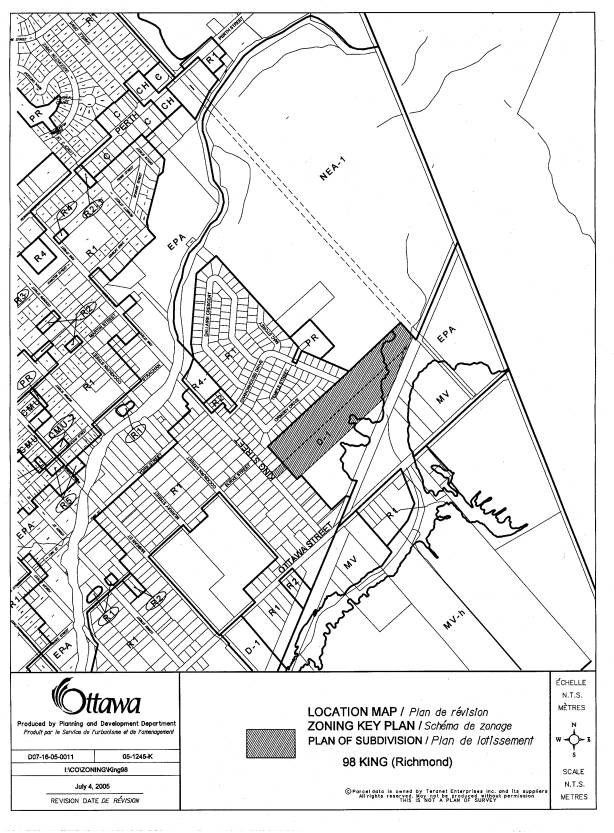
BACKGROUND
The subject site is located at 98 King Street, in the Village of Richmond. The site is situated at the southeast corner of the Village of Richmond, east of King Street, south of Chanonhouse Drive and north of Ottawa Street.
The 7.17-hectare size parcel of land is currently vacant. A wooded area is located on the eastern portion of the property, while the western portion is predominately flat and free of vegetation. The Richmond Conservation Area abuts the subject property to the northeast, where denser vegetation is located. The Marlborough Creek passes along the southern limit of the subject property and flows in a southwest to northeast direction, meandering along the southern limit of the subject lands. Although the creek neither dissects the subject property nor passes through any proposed residential lots, the floodplain from the creek extends towards several proposed lots within the plan of subdivision. Furthermore, a Canadian National (CN) railway line is located south of the subject land and, at its closest point to the tracks, comes within 15 metres of the subject property line.
Adjacent land uses include single detached homes to the northwest along Chanonhouse Drive and Ormsby Drive. Single detached homes are also situated to the west along both sides of King Street. The Canadian National railway and Future Development Lands are located south of the proposed subdivision, while the Richmond Conservation Area (designated a ‘Natural Environment Area’ in the Official Plan) and Chanonhouse Park are located directly to the northeast.
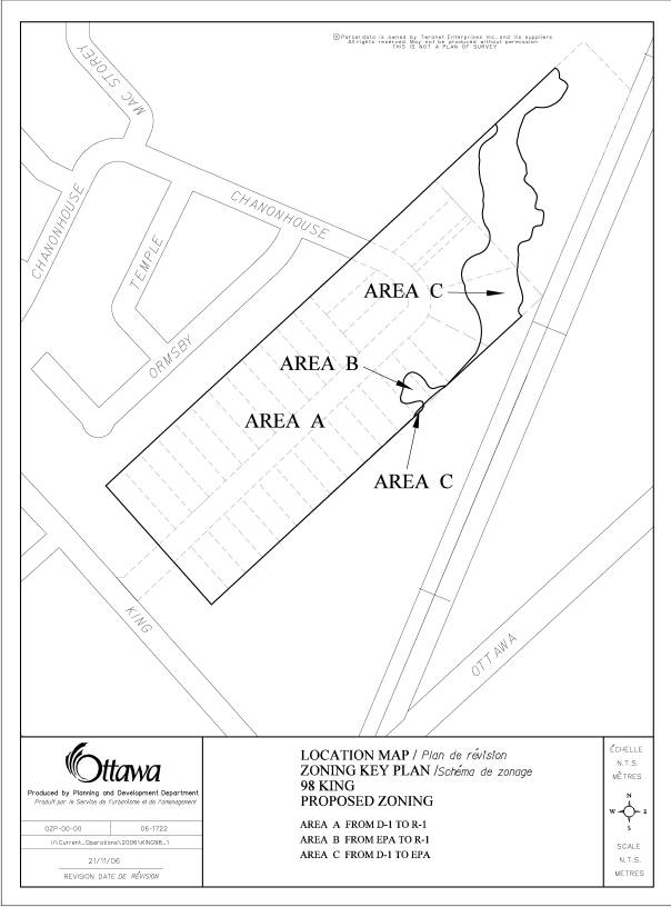
Purpose of Zoning By-law Amendment:
The purpose of the Zoning By-law amendment is to rezone the subject lands from Future Development Lands (D-1) to a Residential Type 1 zone (R-1) such that residential uses will be permitted with minimum 20-metre frontages and 690 square metre lot areas, resulting in the creation of 34 residential lots. Two other areas on the subject lands will be rezoned from D-1 to Environmental Protection Area (EPA) and from EPA to R-1 to reflect the new floodplain mapping conducted by the Rideau Valley Conservation Authority (Jock River Flood Risk Mapping Project).
DISCUSSION
Official Plan:
The Official Plan designates the subject lands as "Village". The Village designation permits a variety of land uses, including a wide range of housing forms to meet the needs of the Village's population.
The Richmond Village Plan designates the subject site as "Residential". This designation permits residential uses characterized by but not limited to low, medium or high density housing.
Details of Current and Proposed Zoning:
The Goulbourn Zoning By-Law zones the subject property "Future Development Zone 1" (D-1) and Environmental Protection Zone (EPA). The D-1 zone only permits existing residential and non-residential uses, and a Single Detached Dwelling on an existing lot. The applicant wishes to rezone the subject land from D-1 to a "Residential Type 1 Zone" (R-1). Lands located east of the proposed lots will be zoned Environmental Protection Area zone (EPA) to permit passive recreation and to aid in preserving existing vegetation and the floodplain of Marlborough Creek.
Noise and Vibration Issues:
a) Noise
An Environmental Noise Impact Assessment was required to address local noise sources and make recommendations for noise control measures. The Report demonstrated where noise levels met both Ministry of Environment (MOE) guidelines and City Environmental Control guidelines. Where noise levels exceeded these thresholds the mandatory warning clauses were written into the Draft Plan of Subdivision conditions.
The degree to which levels exceeded MOE and City guidelines were minor in nature and, thus, the warning clauses required are deemed precautionary.
b) Vibration
A Vibration Impact Assessment has been prepared to address the impacts the Canadian National (CN) rail line, may have on the proposed development. This vibration assessment was conducted according to the City requirements as set out in the Official Plan Section 4.8.8 (Road, Rail, Transit Corridor Noise and Noise from Stationary Sources). The conclusion of the Report indicated that the measured vibration levels from passing trains and the estimated vibration levels of freight trains at the locations of the proposed residences are acceptable.
Concurrent Application:
A Plan of Subdivision application (D07-16-05-0011) has accompanied the subject Zoning By‑law amendment, to permit the subdivision of 34 residential lots fronting onto a public street. Access for the public street is proposed from both King Street and Chanonhouse Drive. The proposed lots will have minimum frontages of 20 metres and minimum lot areas of 690 square metres. A pathway block will connect the proposed public street to a storm water management block and an Environmental Protection Area zone (EPA) in the rear of the subdivision.
Rationale for Approval:
Staff support the subject application on the basis of the Village Policies (Section 3.7.1) of the Official Plan, which states that a range of residential uses are permitted to meet the needs of the Village's population. The concept to permit a Residential Type 1 (R-1) zone on the subject land is consistent with the character of the surrounding community. Lands directly to the north, along Chanonhouse Drive and Ormsby Drive are also zoned R-1. Furthermore, lands to the west, across King Street, are of the same character.
The proposed zoning from EPA to
D-1 (Area B in Document 2) and D-1 to EPA (Area C in Document 2) conforms with
the latest floodplain mapping provided by the Rideau Valley Conservation
Authority. Furthermore, the EPA lands
will act as a development buffer between the residential uses and the existing
Natural Environment Area abutting the property to the northeast.
ENVIRONMENTAL IMPLICATIONS
The Official Plan indicates a Natural Environmental Area (NEA) designation extending onto the subject parcel of land, along the north portion of the site. Further investigation revealed that the area depicted jutting into the Village designation was clearly not intended to be part of the current NEA boundary.
The current NEA Official Plan designation is not consistent with the NEA-1 Zoning boundary found within the former Township of Goulbourn Zoning By-law. This discrepancy has been identified with more precise site evaluation and mapping. Section 3.2.2 (7) in the Official Plan allows for boundary adjustments when more accurate maps are provided, without an Official Plan amendment. The NEA boundary within the Goulbourn Official Plan and the Richmond Conservation Area Management Plan follow the zoning boundary and does not intrude into the subject lands. For this reason the new Official Plan NEA boundary is an anomaly which will be corrected in future Official Plan reviews.
RURAL IMPLICATIONS
There are no
anticipated land use conflicts pertaining to this zoning application. The proposed Zoning By-law amendment is in
keeping with the surrounding character of the adjacent neighbourhood, and is in
keeping with the residential policies of the Village of Richmond.
CONSULTATION
Notice of this application was carried out in accordance with the City’s Public Notification and Consultation Policy. The Ward Councillor is aware of this application and the staff recommendation.
Detailed responses to the notification/circulation are provided in Document 3.
FINANCIAL IMPLICATIONS
APPLICATION PROCESS
TIMELINE STATUS
The application was not processed by the "On
Time Decision Date" established for the processing of Zoning By-Law amendments
due to significant time allocated to adequately address the concerns of the
Conservation Authority and CN Rail with respect to the required Hydrogeological
Report and Noise Study.
SUPPORTING DOCUMENTATION
Document 1 Location
Map
Document 2 Details
of Recommended Zoning
Document 3 Consultation Details
DISPOSITION
Corporate Services Department, City
Clerk's Branch to notify the owner (Hendrikus and Paula de Kemp, 2069 Woodroffe
Avenue, Nepean, ON, K2G 3H1), Signs.ca, 866 Campbell Avenue, Ottawa, ON K2A 2C5, and Ghislain Lamarche, Program
Manager, Assessment, Financial Services Branch (Mail Code: 26-76) of
City Council's decision.
Planning, Transit and the Environment
Department to prepare the implementing by-law, forward to Legal Services Branch
and undertake the statutory notification.
Corporate Services Department, Legal Services
Branch to forward the implementing by-law to City Council.
LOCATION MAP Document
1
DETAILS OF RECOMMENDED ZONING Document
2
CONSULTATION DETAILS Document
3
NOTIFICATION AND CONSULTATION
PROCESS
Notification and public consultation
was undertaken in accordance with the Public Notification and Public
Consultation Policy approved by City Council for Zoning By-law Amendments. A public meeting was held in the community
on October 17th, 2005, where 23 members of the public attended.
PUBLIC COMMENTS
Comment 1. Roads and Traffic
- Traffic on King Street will increase as a result of this development, which will compound existing traffic issues on King Street. Can any traffic calming measures be implemented to alleviate these concerns?
- Can any mitigating efforts, such as landscaping, be put in place to prohibit car lights on Chanonhouse Drive from adversely effecting the property at 95, 97, 99 King Street?
- Why isn’t there going to be a cul-de-sac at the end of the proposed street? This would reduce traffic.
- Will the street have curbs and a sidewalk on one side of the street?
Response:
The addition of 34 units will have a minimal impact on both Chanonhouse Drive and King Street and will not generate an excess amount of traffic.
If the local community has noticed increases in
speed along King Street or Ottawa Street then the following actions can be
taken to inquire about traffic calming measures:
·
Contact Bob
Streicher (580-2424 ext 22723; bob.streicher@ottawa.ca) at the City (Traffic Operations and Parking)
to request traffic calming measures from the Area Traffic Management Program.
· Contact Jerry Thomas (580-2424 ext 28187; jerry.thomas@ottawa.ca) at the City (Traffic Operations and Parking) to request a community radar gun program which can help alleviate speeding
· Contact Police Services to inquire about local enforcement issues
It appears that the houses most impacted from vehicles turning left and right onto King Street from the new extension of Chanonhouse Drive are 97 and 99 King Street. The new road is positioned such that vehicles will directly face the shared lot line of the above houses, and therefore the impact will be reduced.
The plan to connect Chanonhouse Drive to King Street provides a second emergency vehicle access to the neighbourhood in the event the current access at Chanonhouse Drive and King Street is blocked. Furthermore, the extension of Chanonhouse Drive will provide for better connectivity and integration of the proposed development to the existing neighbourhood.
Comment 2. Preservation of Existing Vegetation
- The natural tree line along the north and south boundaries of the subject land should be preserved; will this be achieved?
- Do proposed lots 1-12 (along the north side of the proposed street) own into the row of trees lining the rear yards? Can these property owners develop into this area of vegetation?
- If an owner wanted to install a fence in their rear yard, could they take down the existing trees along the rear property line? An agreement to limit the cutting of trees should be implemented.
Response:
The natural tree line in the rear of the proposed lots 1-12 and 15-31 will be identified in the subdivision agreement and in all Offers of Purchase and Sale informing prospective purchasers that the existence of the deciduous hedgerows along the rear portions of these properties (north interior side yard of lot 15) should be retained for aesthetic and local wildlife value.
The proposed lots, 1-12, do own portions of the existing vegetation in their rear yards. The proposed zoning will prohibit development of the main dwelling unit within nine metres of the rear yard lot line and an accessory structure within one metre of the rear lot line. Although there is currently no tree-cutting by-law functioning in the City of Ottawa, all measures will be taken to attempt to prohibit the cutting of the existing trees along the property line.
Comment 3. Miscellaneous
- Can street lighting be of the same character as the existing neighbourhood to the north (Ormsby Drive, Temple Street, Chanonhouse Drive)? Existing residents wish to keep the neighbourhood in the same character and lighting.
- Has the EPA zone along Marlborough Creek changed over time or gotten smaller?
- Is there going to be a storm water management pond, and if so will it be fenced?
Response:
Street lighting will be addressed during the detailed planning stage of the Plan of Subdivision. However, the proponent has been made aware that there is a desire to keep street lighting in the same character as the existing neighbourhood.
The Environmental Protection Zone (EPA) has changed shape over time. The Rideau Valley Conservation Authority regularly updates their floodplain mapping, and as such the EPA zone evolves as the creek’s floodplain evolves and changes over time.
The storm water management facility will not be in the form of a pond, but rather a swale that meanders several times before discharging water towards Marlborough Creek. Fencing of the swale will not be required.
Comment 4. Services
- Why is this development serviced via private wells? Why is it not on city services?
- Will all services be buried, ie Hydro, Bell, Cable and Gas?
Response:
Although some
existing neighbourhoods in Richmond have communal well water systems, the
City’s Official Plan states that “new development in the City’s rural area will
occur primarily on the basis of private individual services.” This policy reflects the concerns regarding
liability, maintenance and operation of such communal systems.
Yes, services such as Hydro, Bell, Cable and Gas will be buried within the road allowance.
City water services are not available within the Village of Richmond.
Comment 5. Housing Development
- Is there a consideration to connect the proposed development to the D1 zone to the south?
- How many housing units exist in the development east of King Street, and north of the proposed development?
- Are the lots going to be sold to a developer or individually?
- When will development begin?
Response:
Due to development constraints created by the railway corridor with respect to noise, vibration and required setbacks, there will be no street connection contemplated from the subject site to the lands zoned D-1 to the south. Access will remain from King Street to lands south of the subject site.
There are currently approximately 140 single-family dwelling units within the existing subdivision north of the subject lands (Mac Storey St., Chanonhouse Dr., Ormsby Dr., Temple St., and Dallaire Cres.)
The lots are proposed to be sold be sold individually, and developed by individual builders. Development will commence once the Plan of Subdivision is registered and all outstanding issues and conditions are satisfied.
ADVISORY COMMITTEE COMMENTS
Ottawa Forest and Green Space Advisory Committee (OFGAC):
The area being rezoned for the residential lots is currently vacant land with a hedgerow on the northwest and southeast borders. The area zoned as EPA is a woodlot however, it does appear that the Environmental Protection Area does skirt up into proposed lots 27, 28 and 29.
It is recommended that the developer retain and protect the hedgerow during construction particularly the larger coniferous and deciduous trees. The City should retain and protect the larger trees in the woodlot as well as respect the setback restrictions to the Marlborough Creek and the Environmental Protection Area when developing creating the parkland and stormwater management facility.
Advisory Committee Recommendations:
- Retain the larger calliper trees in the two hedgerows, which are at the back of the proposed residential lots.
- Retain the larger calliper trees in the woodlot when creating the parkland and stormwater management facility.
- Protect the root zones of the larger calliper trees being retained, out to the drip line during development on all sites.
- Respect the official setback restrictions to the Marlborough Creek and the Environmental Protection Area during the placement and construction of the stormwater management facility and the drilling of the wells for the residential lots.
- Consider not approving proposed lots 27, 28 and 29 which appear to encroach on the EPA zone
- Respect the recommendations of the Environmental Impact Statement (EIS) done on the EPA zone when designing and constructing the parkland and stormwater management facility.
- Keep OFGAC reviewer apprised of any future public meetings and of the final decision on both the rezoning amendment and the development proposal for the parkland and stormwater management facility.
Staff Response:
- Trees within the two hedgerows along the north and south ends of the proposed subdivision will be protected through various conditions of the Plan of Subdivision. A Landscape Plan will be required to illustrate where vegetation can be protected; the recommendations of the Environmental Impact Statement and Preliminary Tree Preservation Plan must be implemented on such plan; and within the Purchase and Sale Agreement the deciduous hedgerow will be identified as an environmental asset to be retained.
- When designing the storm water management facility the retention of trees will be addressed on the detailed design plan, and will be further addressed on the required Landscape Plan.
- Conditions within the Plan of Subdivision detail how the applicant/consultant must protect existing trees from damage and destruction. All mitigation efforts must comply with Forestry Services standards.
- All development will be placed outside of the floodplain of Marlborough Creek.
- The EPA zone will not encroach into Lots 27, 28 and 29 as the new floodplain mapping conducted by the Rideau Valley Conservation Authority (Jock River Flood Risk Mapping Project), illustrates the floodplain line no longer encroaches into the rear of these lots. Although this new boundary consumes a greater area of Lots 31 and 32, the capability to locate the dwelling unit, garage, driveway and well outside of the floodplain is not compromised.
- As discussed in the second response, the EIS will be utilized to create and approve the Landscape Plan.
- OFGAC will be notified of future decisions with respect to the Plan of Subdivision and Zoning By-law amendment.