|
6. ZONING – 1500 THOMAS ARGUE ROAD ZONAGE - 1500, CHEMIN
THOMAS ARGUE
|
Committee recommendation
That
Council approve an amendment to the former West Carleton Zoning By-law to
change the zoning of 1500 Thomas Argue Road from RR, Rural Residential, MA,
Airport Industrial and MA(h) to MA, MA-2, MA-3, MA-4, MA-4(h), MA-5 and to
amend to the text of the MA zone as shown in Document 3 and 4 and detailed in
Document 5.
Recommandation du Comité
Que le Conseil approuve une
modification au Règlement de zonage de l’ancien Canton de West Carleton afin de
changer la désignation de zonage du 1500, chemin Thomas Argue de RR, zone
rurale résidentielle, MA, zone industrielle aéroportuaire, et MA(h) à MA, MA-2,
MA-3, MA-4, MA-4(h) et MA-5, et de modifier le texte de la zone MA, tel qu’il
est indiqué dans les documents 3 et 4 et détaillé dans le document 5.
Documentation
1.
Deputy
City Manager, Planning, Transit and the Environment report dated 29 May 2007
(ACS2007-PTE-APR-0127)
2.
Extract
of Draft Minutes 9, Agriculture and Rural Affairs Committee meeting of 14 June
2007.
Report to/Rapport au :
Agriculture and Rural Affairs Committee
Comité d'agriculture et des questions rurales
and Council / et au Conseil
Submitted by/Soumis par : Nancy Schepers, Deputy City Manager /
Directrice municipale adjointe,
Planning, Transit and the Environment / Urbanisme,
Transport en commun et Environnement
Contact
Person/Personne Ressource : Grant Lindsay, Manager / Gestionnaire,
Development Approvals / Approbation des demandes d'aménagement
(613)
580-2424, 13242 Grant.Lindsay@ottawa.ca
|
SUBJECT: |
|
|
|
|
|
OBJET : |
REPORT RECOMMENDATION
That the Agriculture and Rural
Affairs Committee recommend Council approve an amendment to the former West
Carleton Zoning By-law to change the zoning of 1500 Thomas Argue Road from
RR, Rural Residential, MA, Airport Industrial and MA(h) to MA, MA-2, MA-3,
MA-4, MA-4(h), MA-5 and to amend to the text of the MA zone as shown in
Document 3 and 4 and detailed in Document 5.
RECOMMANDATION DU RAPPORT
Que le Comité de l’agriculture et des affaires
rurales recommande au Conseil d’approuver une modification au Règlement de
zonage de l’ancien Canton de West Carleton afin de changer la désignation de
zonage du 1500, chemin Thomas Argue de RR, zone rurale résidentielle, MA, zone
industrielle aéroportuaire, et MA(h) à MA, MA-2, MA-3, MA-4, MA-4(h) et MA-5,
et de modifier le texte de la zone MA, tel qu’il est indiqué dans les documents
3 et 4 et détaillé dans le document 5.
BACKGROUND
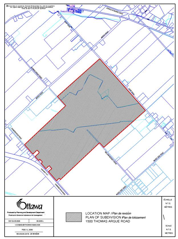
The Carp Airport, 1500 Thomas Argue Road,
is located approximately two kilometres southwest of the Village of Carp. With
an area of 392 hectares the site is south of March Road with frontage on Carp
Road to the east, and Diamondview Road to the west (see Document 1).
The
existing airport facility is centrally located on the site and occupies less
than half of the site area.
Ten existing airport-related businesses are located on site which occupy
an additional area of approximately 3.2 hectares. Land uses surrounding the
airport lands are a combination of active agricultural uses, rural residential,
mineral resource areas and commercial/industrial operations.
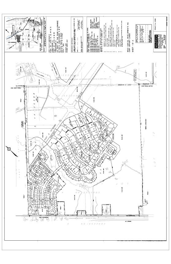
The development proposal
consists of three parts: the Residential Community, the Aerospace Business Park
and the General Aviation Airport.
The residential community is being proposed west
of the existing airport facility with access from Diamondview Road and from
Thomas Argue Road. The residential
community is to consist of 329 residential units: 270 single detached dwellings and 59 townhouse units. The single
dwellings consist of various lot types and sizes as follows: 116 lots with a minimum of 15.3-metre frontage,
24 lots with a minimum of 18.3-metre frontage, 51 lots with a minimum of 21.4-metre
frontage, and 79 Hangar lots with various frontages.
The Hangar lots have been designed to have
direct access to the airport taxiway and runway. Residents will be able to park
their aircraft on their own property close to their house. Communal hangars
will be provided in the residential community for those residents who have an
aircraft, but do not live on a Hangar lot.
The Aerospace Business Park is separated into
two parts: The first part, north of the airport has access from Thomas Argue
Road, while the second part, east of the airport has access from Carp Road.
Like the residential community, the business park will have direct access to
the airport taxiway, runway and facilities. Currently, the business park
contains a number of aircraft hangars, and other airport related facilities and
businesses.
Currently, the airport is being operated by West
Capital Developments (WCD). WCD has an option to purchase the airport from the
City. The General Aviation Airport
contains two runways: a 4000-foot paved
lighted runway (10-28), and a 2200-foot gravel auxiliary runway (4-22). A
taxiway is proposed to link the runways with the residential community and
aerospace business park. A
Fixed Base Operations (FBO) facility was constructed by WCD in 2006.
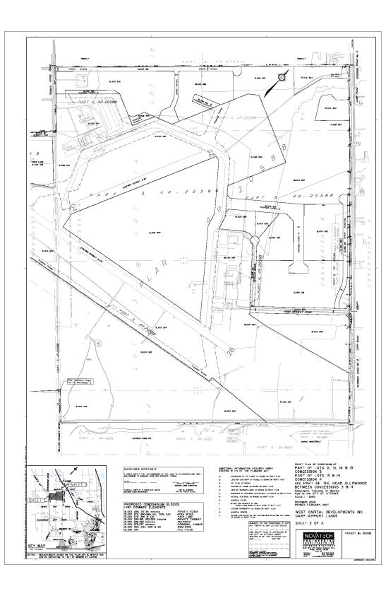
Concurrent Applications
In addition to this zoning application,
this site is also the subject of a draft plan of subdivision application and a
draft plan of condominium application. The subdivision application proposes to
subdivide the property to allow the land uses as described above (see Document
2). The condominium application is a “common elements” condominium which
outlines the areas within the subdivision which will be held in common by the
future residents and business owners. The residential lots and business park
blocks are to be freehold. Conservation lands, stormwater management ponds and
the community park are to be owned by the City. The roads, taxiways, communal
hangars and some parks and greenspaces will be commonly owned by the future
residential and business park landowners. Ongoing maintenance will be through a
Condominium Corporation with the exception of the roads which will be
maintained by the City under a Municipal Capital Facilities Agreement (MCFA).
A
Class Environmental Assessment (EA) process has run concurrently with the
applications for draft plan of Subdivision/Condominium and the Zoning By-law
amendment. The purpose of the EA process was to identify and analyze the
various servicing options related to water supply and sanitary sewage for the
proposed development.
Purpose of the proposed Zoning By-law Amendment
The purpose of this amendment is to implement the subdivision proposal. The existing zoning is Airport Industrial (MA Zone), Rural Residential (RR Zone) and Airport Industrial “holding” (MA(h) Zone). In addition to allowing airport, airstrip and aircraft hangar, the MA zone permits a range of industrial uses. The existing Rural Residential Zone which applies to the airport lands fronting on Diamondview Road allows single detached dwellings on 0.4-hectare lots. The holding designation that currently applies to the lands adjacent to the east of the RR zone prohibits construction of buildings or structures “until such time as the Master Plan for the Carp Airport has been approved and/or a site plan has been approved by the municipality”.
The proposed Zoning By-law amendment would create a number of airport special exception zones to allow for the creation of an airport accessory residential development. The residential component would include single detached lots, street townhouses, hangar lots and conservation and park uses as listed below and seen in Document 3 and 4. The proposed Zoning By-law amendment would also add a number of service commercial land uses to the existing MA zone and delete a heavy industrial use, as detailed below.
MA-2 Zone, Airport Industrial Special Zone 2 – Hangar Lots
MA-3 Zone, Airport Industrial Special Zone 3 – Single Dwelling Lots
MA-4 Zone, Airport Industrial Special Zone 4 – Street Townhouses
MA-4(h) Zone, Airport Industrial Special Zone 4
with holding designation – Street Townhouses
MA-5 Zone, Airport Industrial Special Zone 5 – Open Space
DISCUSSION
The Official Plan has designated the subject
lands as “Carp Airport”. The general intent of the policies for the Carp
Airport designation is to ensure that the airport provides facilities for the
general aviation community, but also to explore opportunities to “strengthen
the local economic and employment role of the facility”. Section 3.10.2 (4),
specifically refers to the opportunity of providing residential development
adjacent to the airport, where the residential development includes provisions
for aircraft storage. The development proposals under consideration will
subdivide and ensure infrastructure improvements including roads, sanitary and
water servicing, public and private recreation lands, pedestrian pathways and
sidewalks, as well as, taxiways and hangars (private and communal) which will
allow for the development for both aerospace business park and airport
accessory residential uses. It is anticipated that such improvements to the
business park, ongoing improvements to the airport, and creation of a
residential neighbourhood will attract new residents, new businesses and
associated employment and economic benefits to the rural area.
Section 4.2 of the Official Plan, Adjacent to
Land-Use Designations, requires
that adjacent land uses and Official Plan designations be considered when
assessing the appropriateness of a planning proposal. The lands immediately
south of the airport are designated Sand and Gravel Resource Area, while lands
to the south west are designated Limestone Resource Area. Mineral Resource Official Plan policies
restrict residential development within 500 metres of a Limestone Resource Area
and within 300 metres of a Sand and Gravel Resource Area. Lands along the south
boundary of the Airport Lands are within these constraint areas. No development is being proposed by the
subdivision within these 300-metre and 500-metre constraint areas with the
minor exception of a small block of townhouses which is being proposed just
inside the 300-metres distance from an existing gravel pit.
Section 4.2 of the Official Plan requires
that the Minimum Distance Separation (MDS) formula be applied to any
development being proposed adjacent to a farm.
This minimum separation distance calculation was applied to the existing
farms north east and north west. No
development is being proposed within these separation distances.
Section 4 of the Official Plan “Review of
Development Applications” also sets out the studies and plans that must be
prepared in support of development applications. In keeping with these
requirements, the following studies were received in support of the Carp Airport
Applications: Planning Rationale, Stormwater Site Management Plan, Phase 1
Environmental Site Assessment, Geotechnical Investigation, Integrated
Environmental Review, Preliminary Tree Conservation and Planting Plan, Traffic
Impact Study, and Servicing Strategy Report. These reports were reviewed by
City Staff and found to be acceptable.
This site is within the Carp River Watershed
Subwatershed Study area. The Integrated Environmental Report and the Stormwater
Management Study demonstrate how the development has been designed to meet the
recommendations of the study and set the framework and targets to be met
through the final engineering design.
Section 2.3.2 of the Official Plan sets out the
Strategic Directions for Water and Wastewater Services. In particular
subsection 4d, states that the City will provide for the creation of new Public
Service Areas to support economic development in unique situations in the rural
area, such as the Carp Airport. The
preferred water supply option has been identified as: low flow water supply
from Carp Village, with communal on site storage and distribution. The
preferred sanitary alternative identified is small bore sewers to an on site
communal sewage treatment facility with subsurface disposal.
Details of Proposed Zoning
In general the proposed Zoning By-law amendment
application is proposing to lift the holding designation and rezone the western
portion of the property to allow for airport accessory residential development.
The airport facility and the aerospace business park would remain within the
current MA zone with the addition of a number of permitted uses and revisions
to a number of zone provisions.
Lifting the holding designation
The subject application is proposing to lift the holding designation which currently applies to a small portion of the land running parallel to Diamondview Road in the western portion of the property. The existing Zoning By-law prohibits construction of buildings or structures on lands zoned MA(h) “until such time as the Master Plan for the Carp Airport has been approved and/or a site plan has been approved by the municipality”. The intent of this holding designation was to prohibit any airport-related development until such time as the lands could undergo a comprehensive land use planning process. With the completion of the draft plan of subdivision, draft plan of condominium and Class Environmental Assessment process, the appropriate design, layout and land uses have been determined. The technical support documents for the planning applications and Class Environmental Assessment have been submitted and reviewed by City staff and the Conservation Authority and have been found to be acceptable. As such it would be appropriate to lift the holding designation.
MA Zone, Airport Industrial: Text Revisions
The proposed Zoning By-law amendment is establishing a number of changes in zone provisions and permitted uses to the parent MA (Airport Industrial) zone. When the MA zone was prepared initially to apply to the airport it was based on the airport as one lot. With the subdivision of land through the approval of the draft plan of subdivision into a number of different business park blocks many of the zone provisions are no longer appropriate. The “zone details” presented in Document 5 show in detail the proposed changes to the Zoning By-law. These changes are discussed in general below.
Building setbacks similar to other business parks are being proposed including: 12 metre minimum front and exterior side yard setbacks, 7.5 metre rear yard setback and 4.5 metre interior sideyard. These setbacks are replacing the larger setbacks to adjacent zones and the setback for parking spaces that are found in the current by-law appropriate when the airport was one lot.
Landscape buffer widths are also being reduced. Here again the landscape buffer widths that were included in the existing zone provisions were based on the Airport as one lot. The draft plan of subdivision has incorporated landscape buffer strips of appropriate widths along Diamondview Road and Carp Road and along the north property line of an existing rural residential lot fronting on Diamondhead Road. An open space type zone is being created to the rear of two existing residences fronting on Diamondview Road and no development is being proposed adjacent to the two other rural residential lots fronting on Diamondview. A new buffer strip requirement of a minimum of ten metres is being proposed in the new By-law. With this reduction in buffer width the inclusion of the provisions which allow certain works in the buffer strip are no longer necessary and have been deleted from the new Zoning By-law with one exception. The definition of landscape buffer has been revised to prohibit parking lots within landscape buffers.
A number of new uses are being proposed to be added to this zone; new commercial, service and recreational uses to serve the needs of the employees and the airport passengers, pilots and flight staff. These new uses include a hotel, motel, neighbourhood store, personal service shop, restaurant (excluding a fast food), and a public and private park. A new airport related use “an airport sales dealership” is also being proposed. An institutional use, a post secondary institution is proposed to be included. This would allow for post secondary institutions, or satellite campuses associated with existing colleges or universities to be created to provide instruction related to the aerospace industry. Under the existing zoning “a bulk tank” is a permitted use. This use is a “heavy industrial” use and could potentially lead to land use conflicts. It is proposed that this use be deleted from the list of permitted uses.
Special Exception Zones
Section 3.10.2 (4), of the Official Plan specifically refers to the opportunity of providing residential development adjacent to the airport, where the residential development includes provisions for aircraft storage. The draft plan of subdivision and the implementing Zoning By‑law include three types of residential housing which conforms to this Official Plan policy. The first is the hangar lots, lots which have frontage on both a street and a taxiway and are large enough to accommodate both a house and associated garage and a private hangar. The second type of residential lots are those which are similar to lots in a village neighbourhood but have easy access to communal hangars. It is a requirement of the subdivision conditions that the communal hangars be provided at a ratio of one per four residential units (based on design capacity). The third is a small cluster of townhouses central to the development. Three special exception airport zones have been created to allow for these forms of residential development.
MA-2 Zone, Airport Industrial Special Zone 2 – Hangar Lots
The draft plan of subdivision delineates 79 residential hangar lots. The MA-2 zone has been formulated to permit the development of residential lots to allow for the construction of a residence (including garage) and a hangar on the same lot. The zone sets out zone provisions appropriate for a private hangar, as well as, the residence. The detailed provisions are found in Document 5. In general, they include a minimum lot area of 900 square metres and frontage of 30 metres, a minimum frontyard setback of three metres for the house but six metres for a garage. Minimum rear yards for the house would be 7.5 metres but five metres for the hangar. These lots are intended to contain both a hangar and a residence and are not to be developed only with a hangar or only as a residence. A provision has been contained in this zone to ensure that this intention is met.
This zone also permits the construction of communal hangars on separate blocks. Zone provisions have been developed for these blocks and include a minimum two-metre setback from all lot lines and a minimum two-metre landscape strip in all yards. Building height is restricted to 12 metres and parking spaces are to be provided at a ratio of 0.25 spaces per capacity of communal hangar.
MA-3 Zone, Airport Industrial Special Zone 3 – Single Dwelling Lots
The draft plan of subdivision shows 270 single detached units with varying frontages as follows: 116 lots with a minimum of 15.3-metre frontage; 24 lots with a minimum of 18.3-metre frontage; and 51 lots with a minimum of 21.4-metre frontage. The application proposes that a new special exception zone, MA-3 zone, be created with appropriate zone provisions to allow for development of these lots. The details of the setbacks and other zone provisions are included in Document 5. In general, these include minimum lot area of 540 square metres and lot frontage of 15 metres, front yard setbacks of four metres with six metres for single car garages and rear yards of 7.5 metres.
MA-4 Zone, Airport Industrial Special Zone 4 –
Street Townhouses and MA-4(h)
The MA-4 zone has been formulated to allow for
the construction of street townhomes. These are similar to standard street
townhome blocks and the setbacks and other zone provisions are standard for
townhouse development. The details of this zone are found in Document 5 and in
general include minimum lot area of 180 square metres, frontage of six metres,
setbacks to the house of four metres and the garage of six metres and rearyard
setbacks of 7.5 metres.
One of the blocks of townhomes is within the
300-metre constraint area of adjacent land zoned and/or used for pit
operations. Development of this block will not be permitted “until either the pit is exhausted and
licence surrendered or an impact assessment study is completed which
demonstrates that the mineral aggregate operation will not be negatively
impacted by the proposed residential development”. This block will be placed in
a “holding designation” until one of these criteria is met.
MA-5 Zone, Airport Industrial Special Zone 5 – Open Space
The MA-5 zone has been created to be applied to
open space lands. This zone would permit public and private parks, and
conservation uses. As public uses are permitted in all zones stormwater
management ponds would also be permitted. It is to apply to the conservation
lands comprised of the Carp Creek Corridor and the mature woodlot delineated
through the plan of subdivision central to the residential portion of the
development. It will also apply to the community public park at the
intersection of the new road at the north boundary of the residential portion
of the development and Thomas Argue Road and the private park on the west side
of the Carp Creek Corridor. Stormwater management ponds on either side of the
Carp corridor between the residential development and the community park are
also proposed to be zoned MA-5. All of these areas will the exception of the
private park are lands that are to be dedicated to the City through the
registration of the subdivision. Zone provisions for any buildings constructed
in the private or public park have been included in the zone details found in
Document 5. These include minimum front and exterior sideyard setbacks of 12
metres, rear yard of 7.5 metres except adjacent to a residential use where it
would be 10 metres.
Conclusion
Staff are recommending approval of the proposed
Zoning By-law amendment as shown in Document 3 and 4 and detailed in Document
5. The subject application is in conformity with the Official Plan policies for
lands designated “Carp Airport”, as well as, the applicable rural Official Plan
policies, and policies associated with the “Adjacent to Land-Use Designations”,
“Review of Development Applications” and “Strategic Direction for Water and
Wastewater Services” sections of the Official Plan. The Zoning By-law will
serve to implement the draft a plan of subdivision, the draft plan of
condominium and the concurrent Class EA recommendations.
ENVIRONMENTAL IMPLICATIONS
In order to protect
Carp Creek and the associated fish habitat a minimum 60-metre creek corridor
will be protected from development. This area will be owned by the City and the
only use will be for passive recreational pathways. The Zoning By-law amendment
is establishing the MA-5 Zone which recognizes the conservation and passive park
use.
The extensive woodlot on site provides wildlife habitat. As part of the applicant’s environmental review of the site the most undisturbed and mature forest area was identified to be along the western edge of the site just south of the cleared area. This wooded area will not be developed and will be owned by City to ensure its protection. This wooded area will be zoned MA-5 similar to the creek corridor. Forest along the southern edge of the site is also not being proposed for development at this time and will remain in the MA “ parent” zone similar to the remainder of the airport. Any development of this land would require additional planning applications.
RURAL IMPLICATIONS
The subject application and companion
development applications will subdivide, introduce new land uses and ensure
infrastructure improvements including roads, sanitary and water servicing,
public and private recreation lands, pedestrian pathways and sidewalks, as well
as, taxiways and hangars (private and communal). It is anticipated that such improvements to the business park,
ongoing improvements to the airport, and creation of a residential
neighbourhood will attract new residents, new businesses and associated
employment and economic benefits to the rural area.
CONSULTATION
Notice of this application was carried out in
accordance with the City's Public Notification and Consultation Policy. Details of the consultation can be seen in
Document 6. The Ward Councillor is
aware of this application and the staff recommendation and has concurred with
the conditions of draft plan of subdivision and draft plan of condominium.
FINANCIAL IMPLICATIONS
N/A
APPLICATION PROCESS
TIMELINE STATUS
The application was not processed by the
"On Time Decision Date" established for the processing of Zoning
By-law amendments. A Class
Environmental Assessment process, to determine the appropriate water and
sanitary servicing solution, was run concurrently with the subject application
and the companion subdivision and condominium approval process.
SUPPORTING DOCUMENTATION
Document 1 Location Map
Document 2 Plan of Subdivision
Document 3 Proposed Zoning
Document 4 Proposed Zoning showing Current Zoning
Document 5 Details
of Recommended zoning
Document 6 Consultation Details
DISPOSITION
City Clerk’s Branch, Secretariat Services to
notify the proponent, John Phillips, West Capital Developments, applicant,
Murray Chown, Novatech Engineering, 200-240 Michael Cowpland Drive, Kanata ON,
OttawaScene.com, 174 Colonnade Road, Unit #33, Ottawa, ON K2E 7J5, Ghislain Lamarche, Program Manager,
Assessment, Financial Services Branch (Mail Code: 26‑76) of
City Council’s decision.
Planning, Transit and the Environment
Department to prepare the implementing by-law, forward to Legal Services Branch
and undertake the statutory notification.
Legal Services Branch to forward the
implementing by-law to City Council.
LOCATION MAP DOCUMENT
1
DRAFT PLAN OF SUBDIVISION DOCUMENT
2
PROPOSED ZONING DOCUMENT
3
PROPOSED ZONING SHOWING CURRENT
ZONING DOCUMENT 4
DETAILS OF RECOMMENDED ZONING DOCUMENT
5
Amend Section 17 of By-law
No. 266 of 1981 (West Carleton Zoning By‑law):
(1) to add the following to the list of
permitted non-residential uses in 17(1)(b):
an aircraft sales dealership
a club
a commercial school
a
hotel
a
motel
a
neighbourhood store
a
personal service shop
a
post secondary institution
a
private park
private
water, sanitary and storm water infrastructure
a
public park
a
restaurant excluding restaurant – fast food
(2) to delete the use “a bulk tank” from the
list of permitted uses
(3) to delete 17(2)(e) and replace it with
the following:
(e) BUILDING SETBACKS FOR NON-RESIDENTIAL USES:
(i) BUILDING SETBACK, FRONT (minimum): - 12.0
metres
(ii) BUILDING SETBACK, FLANK (minimum): - 12.0
metres
(iii) BUILDING SETBACK, REAR (minimum): - 7.5
metres
(iv) BUILDING SETBACK, SIDE (minimum): - 4.5
metres
(4)
to
delete the wording of 17(2)(i) (Parking Space Location);
(5)
to add
site specific loading space requirements as per chart below:
|
I Land
Use |
Minimum
Number of Loading Spaces Required per Square Metres of Gross Floor Area |
|||||
|
II Less
than 350 m² |
III 350-999
m² |
IV 1000-1999
m² |
V 2000-4999
m² |
VI 5000-14999
m² |
VII 15000
m² and over |
|
|
(a) warehouse,
transportation depot, printing establishment, manufacturing plant,
maintenance garage, fabricating plant, assembly plant, post secondary
institution |
0 |
1 |
2 |
3 |
||
|
(b) building for research,
design or testing, business office |
0 |
1 |
2 |
|||
|
(c) aircraft sales
dealership, factory outlet, merchandise service shop, neighbourhood store,
personal service shop, restaurant excluding restaurant – fast food |
0 |
1 |
2 |
|||
|
(d) aircraft
hanger, airport, club, commercial school, hotel, motel |
0 |
1 |
2 |
|||
|
(e) residential
uses |
none required |
|||||
(6) to
delete 17(2)(k)(ii) (setback to lot
line of Gasoline Pump Island);
(7) to add the words “but does not include a
parking lot,” to 17(2)(n) (Definition of Landscape Buffer);
(8) to
delete 17(2)(o) and replace it with the following:
(o) LANDSCAPE BUFFER WIDTH:
A landscape buffer a minimum width of 10 metres
is required
(i) abutting
an RR zone;
(ii) abutting
Carp Road;
(iii) abutting
any other non-industrial zone.
(9) to delete 17(2)(p) and leaving it blank for future use;
(10) to
delete clause 17(3)(b).
2. Amend
Section 17 of By-law
No. 266 of 1981 by
adding the following Special Exception Zones:
(b) MA-2
Zone, Airport Industrial Special Zone 2 – Hangar Lots:
Despite subsection 17(1) and clauses
17(2)(a) to 17(2)(q) the following applies to land zoned MA-2:
(i) the permitted Residential uses are:
-
a fully detached dwelling house
(ii) the permitted non-residential uses are:
-
an airport
-
a communal aircraft hangar
-
a home occupation
-
a private aircraft hangar
-
a private park
-
a public park
-
a taxiway
(iii) a private aircraft hangar is not
permitted without a fully detached dwelling house;
(iv) a private aircraft hangar will generally
be constructed so that its character is in keeping, architecturally, with the
character of the home including exterior materials used;
(v) in this zone land that is legally
transferable but does not comply with the definition of a lot will:
1. be considered to have frontage if it
fronts on a private street; and
2. need
to comply with all zone provisions as if it were a lot
(vi) the zone provisions are:
1. minimum lot area: 900 square
metres;
2. minimum frontage: 30 metres;
3. maximum building area: 30%;
4. minimum front building setback:
(A) 3.0 metres for fully detached dwelling
house,
(B) 6.0 metres for single car garage;
5. minimum flank building setback: 3.0 metres;
6. minimum rear building setback:
(A) 7.5 metres for fully detached dwelling house,
(B) 5.0 metres for garage or private aircraft hangar,
(C) 1.0 metres for sheds and other accessory buildings;
7. minimum side building setback: 3.0 metres;
8. maximum building height: 12.0 metres;
9. minimum dwelling unit area:
(A) ground floor: 90 m²
(B) entire dwelling: 130m²;
10. minimum landscaping area: 30%
11. minimum parking spaces:
(A) 2 for each dwelling unit,
(B) 1 for each home occupation;
12. private aircraft hangar doors must face a taxiway (with latitude for an angle within 60 degrees);
13. maximum rear building setback for a private aircraft hangar: 15 metres;
14. despite (vi) the zone provisions for a
communal aircraft hangar are:
(A) minimum
building setback: 2.0 metres;
(B) a minimum 2.0-metre wide landscape strip
is required in all yards except for lots lines abutting taxiways;
(C) maximum building height: 12.0 metres
(D) minimum parking spaces: 0.25 spaces per each
aircraft based on
capacity of communal
hangar
(c) MA-3 Zone, Airport Industrial Special
Zone 3 – Single Dwelling Lots:
Despite subsection 17(1) and clauses
17(2)(a) to 17(2)(q) the following applies to land zoned MA-3:
(i) the
permitted residential uses are:
-
fully detached dwelling house
(ii) the permitted non-residential uses are:
-
an airport
- an airport security kiosk
-
a home occupation
- a private park
-
a public park
(iii) in this zone land that is legally
transferable but does not comply with the definition of a lot will:
1. be considered to have frontage if it
fronts on a private street; and
2. need to comply with all zone provisions
as if it were a lot
(iv) the zone provisions are:
1. minimum lot area: 530 square
metres;
2. minimum frontage: 15 metres;
3. maximum building area: 40%;
4. minimum front building setback:
(A) 4.0 metres for fully detached dwelling
house
(B) 6.0 metres for a single car garage;
5. minimum flank building setback: 4.0 metres;
6. minimum rear building setback: 7.5 metres;
7. minimum side building setback: 1.2 metres;
8. maximum building height: 10.0 metres;
9. minimum dwelling unit area:
(A) ground floor: 90 m²
(B) entire dwelling: 130m²;
10. minimum landscaping area: 30%
11. minimum parking spaces:
(A) 2 for each dwelling unit,
(B) 1 for each home occupation;
(d) MA-4 Zone, Airport Industrial Special
Zone 4 – Street Townhouses:
Despite subsection 17(1) and clauses 17(2)(a) to 17(2)(q) the following applies to land zoned MA-4:
(i) the permitted residential use is:
- street townhouse;
(ii) the permitted non-residential use is
- home occupation
(iii) despite the by-law definition a street townhouse may be located on a legally transferable parcel of land that has frontage on a private street;
(iv) in this zone land that is legally
transferable but does not comply with the definition of a lot will:
1. be considered to have frontage if it
fronts on a private street; and
2. need to comply with all zone provisions
as if it were a lot;
(v) the zone provisions are:
1. minimum lot area: 180 square metres per
dwelling unit;
2. minimum frontage: 6.0 metres per
dwelling unit;
3. maximum building area: 30%;
4. minimum front building setback:
(A) 4.0 metres for street townhouse house
(B) 6.0 metres for garage;
5. minimum flank building setback: 4.0 metres;
6. minimum rear building setback: 7.5 metres;
7. minimum side building setback
for end unit: 1.5 metres;
8. maximum building height: 2 storeys;
9. minimum dwelling unit area: no minimum;
10. minimum landscaping area: 30%
11. minimum parking spaces:
(A) 2 for each dwelling unit,
(B) 1 for each home occupation;
(vi) on any lands zone MA-4 where there is a holding symbol shown on Schedule A the holding symbol cannot be removed until such time as the following is met:
1. the pit is exhausted and the licence surrendered, or
2. an impact assessment study is completed which demonstrates that the mineral aggregate operation will not be negatively impacted by the proposed residential development.
(e) MA-5 Zone, Airport Industrial Special Zone 5 – Open Space:
Despite subsection 17(1) and clauses 17(2)(a) to 17(2)(q) the following applies to land zoned MA-5:
(i) the permitted uses are:
- community centre
- conservation use
- private park
- private water, sanitary and storm water infrastructure
- public park
(ii) the zone provisions are:
(1) minimum lot area: no minimum
(2) minimum lot frontage: no minimum
(3) maximum building area: 20%
(4) minimum front building setback: 12.0 metres
(5) minimum flank building setback: 12.0 metres
(6) minimum rear building setback:
(A) 7.5 metres, or
(B) where a rear lot line abuts a lot having a residential use located thereon, the minimum rear building setback is 10.0 metres
(7) minimum side building setback: 7.5 metres
(8) minimum building separation: 3.0 metres
(9) maximum building height: 10.0 metres
(10) minimum landscaping area: 50%
(11) minimum parking spaces:
(A) conservation use or forestry use: none required
(B) community centre or building
associated with
private park: 4 spaces per
100 m² of gross floor area
(12) no part of any parking space shall be located closer than:
(A) 1.5 metres to any street line; or
(B) 4.0 metres to any lot line that abuts a lot having a residential use situated thereon.
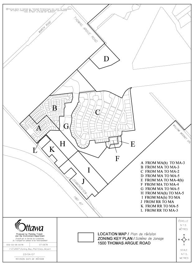
3. Amend Schedule A, Map 3 of
By-law Number 266 of 1981 as
shown on Zoning Key Map contained in
Document 3 attached to this report by:
(1) removing the holding symbol from the
land shown as Area A;
(2) rezoning the land shown as Area A from
MA to MA-3;
(3) rezoning the land shown as Area B from MA to MA-3;
(4) rezoning the land shown as Area C from MA to MA-2;
(5) rezoning the land shown as Area D from MA to MA-5;
(6) rezoning the land shown as Area E from MA to MA-4(h);
(7) rezoning the land shown as Area F from MA to MA-4;
(8) rezoning the land shown as Area G from MA to MA-5;
(9) removing the holding symbol from the
land shown as Area H ;
(10) rezoning the land shown as Area H from MA to MA-5;
(11) removing the holding symbol from the land
shown as Area I ;
(12) rezoning the land shown as Area J from RR to MA;
(13) rezoning the land shown as Area K from RR to MA-5;
(14) rezoning the land shown as Area L from RR to MA-3.
CONSULTATION DETAILS DOCUMENT
6
NOTIFICATION AND CONSULTATION PROCESS
Notification and public consultation was undertaken
in accordance with the Public Notification and Public Consultation Policy
approved by City Council for Zoning By-law Amendments.
No informal public information meetings were held specifically on the zoning application however two public meetings were held in the community to discuss the related subdivision, condominium and Class Environmental Assessment. These meetings were held August 24, 2006 at the Kinburn Client Service Centre and on February 6, 2007 in Carp Village.
PUBLIC COMMENTS
A great deal of public comment was received through the public circulation and notification process. Many of the comments received were related to the subdivision proposal and not related specifically to the zoning. Comments including concern with construction traffic, the need for Diamondview Road upgrades, water and sewer services, airport noise restrictions, runway safety, provision of landscape buffers, and details of the subdivision design relate to the details of the draft plan of subdivision and have been addressed through revisions to the subdivision and/or the inclusion of conditions of draft plan approval. Additional comments related to environmental concerns, including impact on Carp Creek and the existing forest cover, need for recreational space, impacts on rural character, adequacy of the notification and development review process are either of a general nature or can be addressed through this zoning amendment. These are outlined below.
SUMMARY OF PUBLIC INPUT
Environmental concerns related to impact on
Carp Creek and the existing forest cover.
Response:
In order to protect
Carp Creek and the associated fish habitat a minimum 60-metre creek corridor
will be protected from development. This area will be owned by the City and the
only use will be for passive recreational pathways. The zoning by law amendment
is proposing to zone this in the MA-5 Zone which recognizes the conservation
and passive park use.
The extensive
woodlot on site provides wildlife habitat. As part of the applicant’s environmental
review of the site the most undisturbed and mature forest area was identified
to be along the western edge of the site just south of the cleared area. This
wooded area will not be developed and will be owned by the City to ensure its
protection. This wooded area will be zoned MA-5 similar to the creek corridor.
Forest along the southern edge of the site is also not being proposed for
development at this time and will remain in the MA “ parent” zone similar to
the remainder of the airport. Any development of this land would require
additional planning applications.
Subdivision Character: need for
recreational space
Response:
A central common private park area with a clubhouse
will be provided for the airpark residents. Land for a public community park
will be provided at the intersection of Street Six and Thomas Argue Road for
use both by new residents, as well as, existing residents and residents of Carp
Village. The private park adjacent to the Carp Creek corridor and the public
community park will be zoned MA-5- Open Space. This zone lists both public and
private park as permitted uses and sets out the setback provisions for the
construction clubhouse or private community building.
Rural Character: concern with size and style of
lots and homes, not compatible with rural character
Response:
The residential
community is to consist of 329 residential units: 270 single detached dwellings and 59 townhouse units. The single
detached dwellings consist of various lot types and sizes as follows: 116 lots
with 15.3-metre frontages, 24 lots with 18.3-metre frontages, 51 lots with 21.4‑metre
frontages, and 79 Hangar Lots with various frontages.
The form and density
of the residential development being proposed for the airport is similar to
that of a village. The lots are not as small and compact as a suburban
neighbourhood but the lots are not as large as estate residential lots. Lot
size is governed by a combination of location and associated “character” (urban
vs. rural) and servicing. Lots in the rural area are on individual wells and
septics and therefore are required to be 0.8 hectares in size. Lots on the
airport lands are within a “public service area” and therefore a standard
public system or a private communal system can be considered for this development.
As a result, the lots being proposed within the subdivision do not need to be
0.8 ha but rather vary in size providing a range in size similar to a village.
A special exception zone has been created for the non-hangar residential lots
and another for the residential hangar lots. These zones will provide the
opportunity for the creation of residential lots of varying sizes and
configurations.
Rural Character: need for a long-term plan to
protect and sustain the rural land
Response:
One of the goals and objectives of the Official Plan
(OP) is to protect and sustain rural land and the rural economy. The OP
reflects the provincial policies for the protection of agriculture, natural
heritage (wetlands and woodlands), aggregate resources, water, and cultural
heritage and archeology. The subject application has respected all of the rural
OP policies in the current Official Plan. The City has initiated the
formulation of a Rural Settlement Strategy. Open Houses have been planned to
obtain public input. The Strategy will
be looking to further refine rural OP policies, and in particular, will be
looking at urban and village boundaries, settlement areas and country lot
development. Draft policies are expected to be release in spring of 2008.
Notification was insufficient: The on site sign
was the only notice of development applications available to residents.
Response:
Notification to the public of planning applications
and public meetings is set out in the regulations associated with the Planning Act. There
are a number of options for municipalities to choose from. The City of Ottawa
has adopted notification policies which include signage on site to inform the
public of applications received and direct contact with local communities
associations and interest groups that have registered with the City. Notices of
formal public meetings for rezoning applications are sent to members of the
public and associations who request notice as a result of seeing the sign. As
this development also involves subdivision and condominium applications, a
formal public meeting was held in the community and at the request of the Ward
Councillor a second meeting, an informal public information meeting, was held.
As this development required an Environmental Assessment to determine the
appropriate servicing option, notices of the first meeting ran in the Citizen,
Le Droit and the local paper. As the second meeting was not a formal public
meeting required under the regulations of the Planning
Act or Environmental Assessment Act, the notice did not run in the City wide papers
however it did run in the local paper and all participants in the process were
mailed notices directly as well as all landowners within 120 metres of the
airport lands.
Advisory Committee and Community Association
Comments
Comments were received from the Ottawa Forest
and Greenspace Advisory Committee. The Committee notes concern with impacts of
the development on Carp Creek and the other tributaries to the Carp River on
site and the associated fish habitat. Impacts on the existing mature woodlot
are also of concern. These concerns were also raised by the public through the
public circulation and consultation process and from City staff and the
Conservation Authority through the technical circulation. Responses to these
concerns are contained above in item # 2 under Public Comments.
The Environmental Advisory Committee submitted
comments on the applications. The Committee expressed concerns with child and
pet safety, increased air traffic and conflict with migratory birds, safety
issues with proximity to a quarry, impact on rural character/farms and need for
public review process. Many of these comments relate to the companion
subdivision application and have been address through that review and approval
process. The impact on rural character and concern with public review process
are addressed above under public comments. The concern with proximity to quarry
lands is addressed in the Discussion part of this report. Lands along the south boundary of the
Airport Lands are within these constraint areas. In keeping with Official Plan policies no development is being
proposed within these 300 metre and 500 metre constraint areas of adjacent pit
and quarry lands with the minor exception of a small block of townhouses which
will be placed in a holding zone.
The Carp Residents Association has expressed
concern with the identification of the preferred water servicing option and the
impact on the Village water supply system. These concerns are related to the
draft plan of subdivision application and the Class EA for the water and
sanitary servicing and not the subject Zoning By-law amendment.