|
1. OFFICIAL PLAN AND ZONING -
830, 846, 856, AND 860 MARCH ROAD PLAN OFFICIEL ET ZONAGE- 830, 846, 856, ET
860, CHEMIN MARCH |
Committee
recommendationS AS AMENDED
(This application
is not subject to Bill 51)
That Council:
1.
Approve and adopt an amendment to the Official Plan to
redesignate 830, 846, 856, and 860 March Road from "Enterprise Area"
to "General Urban Area" as detailed in Document 2; and
2.
Approve amendments to the former City of Kanata Zoning
By-laws 74-79 and 164‑93 to change the zoning of 830, 846, 856, and 860
March Road from ER (Estate Residential Zone) to CG-4 (Special General
Commercial Zone) and OS1 (Open Space Type 1 Zone), as detailed in Document 3,
and shown in Document 4; and
3.
Approve an amendment to the former City of Kanata Zoning
By-law 164-93 to replace the provisions for CG-4 (Special General Commercial
Zone), as detailed in Document 3.
4. WHEREAS the Report Recommendation of
Planning and Environment Committee Report ACS2007-PTE-APR-0023 contains a minor
error in the Details of Recommended Zoning, Document 3;
AND WHEREAS in numbers 1 and 2 of the said Document 3, reference is made
to “Document 5” and this reference should be changed to read “Document 4” to
properly identify the Zoning Key Plan which identifies the lands to be rezoned;
THEREFORE
BE IT RESOLVED THAT the required correction in numbers 1 and 2 of
the said Document 3 be approved, so that reference is made to “Document 4” and:
That no further notice will be given under
subsection 34(17) of the Planning Act.
RecommandationS modifiÉeS du Comité
(Cette demande n est pas
assujettie au projet de loi 51)
Que le Conseil :
1.
Approuve
et d’adopter une modification au Plan officiel visant à faire passer la
désignation de zonage des propriétés situées aux 830, 846, 856 et 860,
chemin March, de « zone d’entreprises » à « zone urbaine
générale », comme l’indique le document 2;
2.
Approuve
des modifications aux règlements de zonage 74-79 et 164-93 de l’ancienne Ville
de Kanata visant è faire passer la la désignation de zonage des propriétés
situées aux 830, 846, 856 et 860, chemin March, de ER (zone de domaines
résidentiels) à CG-4 (zone commerciale générale spéciale) et à OS1 (zone
d’espaces ouverts de type 1), comme le précise le document 3 et
l’illustre le document 4;
3.
Approuve
une modification au règlement de zonage 164-93 de l’ancienne Ville de Kanata
visant à remplacer les dispositions s’appliquant à la zone CG-4 (zone
commerciale générale spéciale), comme le précise le document 3.
4. ATTENDU QUE la recommandation du Rapport du Comité de
l’urbanisme et de l’environnement ACS2007-PTE-APR-0023 contient une erreur
d’importance secondaire dans les Détails du zonage recommandé, Document 3;
ATTENDU QU’aux points 1 et 2 dudit
Document 3, on fait référence au « Document 5 » et que ladite
référence doit être changée à « Document 4 » afin de définir
correctement le plan clé de zonage qui détermine les terrains dont le zonage
doit être changé;
PAR CONSÉQUENT, IL EST RÉSOLU QUE la
correction demandée aux numéros 1 et 2 dudit Document 3 soit approuvée, afin
que l’on fasse référence au « Document 4 ».
Aucun autre avis ne sera donné en vertu du
paragraphe 34(17) de la Loi sur l’aménagement du territoire.
Documentation
1.
Deputy
City Manager's report Planning, Transit
and the Environment dated
27 June 2007 (ACS2007-PTE-APR-0023).
Report
to/Rapport au :
Planning and Environment Committee
Comité de l'urbanisme et de l'environnement
and Council/et au Conseil
27 June 2007 / le 27 juin 2007
Submitted by/Soumis par Nancy Schepers, Deputy City Manager/
Directrice municipale adjointe
Planning,
Transit and the Environment/ Urbanisme, Transport en commun et Environnement
Contact
Person/Personne Ressource : Grant Lindsay, Manager / Gestionnaire,
Development Approvals / Approbation des demandes d'aménagement
(613)
580-2424, 13242 Grant.Lindsay@ottawa.ca
|
SUBJECT: |
OFFICIAL PLAN and zoning - 830, 846,
856, And 860 March Road (FILE NO. D01-01-06-0015),
(File No. D02-02-06-0089) |
|
|
|
|
OBJET : |
PLAN OFFICIEL
et zonage- 830,
846, 856, ET 860, chemin March |
REPORT
RECOMMENDATIONS
1.
Approve and adopt an amendment to the Official Plan to
redesignate 830, 846, 856, and 860 March Road from "Enterprise Area"
to "General Urban Area" as detailed in Document 2; and
2.
Approve amendments to the former City of Kanata Zoning
By-laws 74-79 and 164‑93 to change the zoning of 830, 846, 856, and 860
March Road from ER (Estate Residential Zone) to CG-4 (Special General
Commercial Zone) and OS1 (Open Space Type 1 Zone), as
detailed in Document 3, and shown in Document 4; and
3.
Approve an amendment to the former City of Kanata
Zoning By-law 164-93 to replace the provisions for CG-4 (Special General
Commercial Zone), as detailed in Document 3.
RECOMMANDATIONS DU RAPPORT
Que le Comité de l’urbanisme et de
l’environnement recommande au Conseil :
1.
D’approuver
et d’adopter une modification au Plan officiel visant à faire passer la
désignation de zonage des propriétés situées aux 830, 846, 856 et 860,
chemin March, de « zone d’entreprises » à « zone urbaine
générale », comme l’indique le document 2;
2.
D’approuver
des modifications aux règlements de zonage 74-79 et 164-93 de l’ancienne Ville
de Kanata visant è faire passer la la désignation de zonage des propriétés
situées aux 830, 846, 856 et 860, chemin March, de ER (zone de domaines
résidentiels) à CG-4 (zone commerciale générale spéciale) et à OS1 (zone
d’espaces ouverts de type 1), comme le précise le document 3 et
l’illustre le document 4;
3.
D’approuver
une modification au règlement de zonage 164-93 de l’ancienne Ville de Kanata
visant à remplacer les dispositions s’appliquant à la zone CG-4 (zone
commerciale générale spéciale), comme le précise le document 3.
BACKGROUND
The applications propose to amend the Official Plan and Zoning By-law to permit a commercial development on the subject lands. The commercial development, as shown on the concept plan submitted with the application, is proposed to be approximately 10000 square metres in GFA and consist of six freestanding buildings.
Site Description
The 3.8-hectare site currently contains three existing residential dwellings. One single-detached dwelling exists on each of 846, 856, and 860 March Road. 830 March Road is currently vacant, undeveloped land. The subject site is characterized by open fields with sporadic vegetation, and tree cover along the eastern edge of the site bordering the Shirley’s Brook corridor. The proposed commercial development also includes the 0.6-hectare property directly to the north, 870 March Road. However, that property is already designated and zoned appropriately to permit the proposed commercial development.
The site is surrounded by: recently constructed townhouses and a stormwater management facility across March Road to the west; a vacant parcel and the heritage “March House” to the south; Shirley’s Brook to the east; and existing rural residential development across Maxwell Bridge Road to the north.
Official Plan
The subject lands were originally proposed for residential uses when they were added to the Urban Area in 1997. The designation was changed to permit employment uses in 2000, and to permit a mix of employment and residential uses in 2002. The site was designated as Enterprise Area on Schedule “B” of the Official Plan when the plan was adopted in 2003, and this designation remains today. This designation permits employment uses and a variety of complementary uses, such as service commercial. Residential uses are permitted in the Enterprise Area subject to an amendment to the Zoning By-law. This designation is intended to maintain land to be primarily places of business and economic activity. The proposed commercial development is of a type and scale that would not be considered “service commercial” and thus is not permitted in the Enterprise Area designation. The application proposes to change the designation to General Urban, which would permit the proposed uses. The staff recommended Official Plan amendment is provided in Document 2.
Zoning By-law
The site is currently zoned as ER (Estate Residential) in the former City of Kanata By-law 74-79 (March Rural). This zone permits one single-detached dwelling, agricultural uses, and nature conservation and management uses.
The requested Zoning By-law amendment is to change the zoning on the site to a zone that will permit a 10000 square metre commercial development to serve the local community. The staff recommended Zoning By-law amendment proposes to remove the subject lands from the former City of Kanata By-law 74-79 and add the lands to By-law 164-93, and change the zoning from ER (Estate Residential Zone) to CG-4 (Special General Commercial Zone) and OS1 (Open Space Type 1 Zone). In addition, staff propose to change the provisions of the current CG-4 zone.
DISCUSSION
Staff have
recommended special provisions for the proposed CG-4 (Special General
Commercial Zone) to satisfy the intent of the Official Plan. Staff recommend that medium- and
high-density residential uses be permitted on the site, though only above the
main floor and to a maximum of 150 units.
Staff also recommend that office uses be permitted to exceed the maximum
floor area, to provide greater development opportunity for these types of
uses. The proposed zoning encourages
buildings to be oriented toward a public street. Finally, the recommended zoning includes an OS1 (Open Space Type
1 Zone) measuring 15 metres from the top-of-bank of the Shirley’s Brook. The details of recommended zoning are
included in Document 3.
Rationale
Removal of Enterprise Area Lands
The Provincial Policy Statement (PPS) indicates that planning authorities may permit conversion of lands within employment areas to non-employment uses through a comprehensive review, only where it has been demonstrated that the land is not required for employment purposes over the long term and that there is a need for the conversion. As part of a 2005 City-initiated Official Plan Amendment, staff recommended that the designation of these lands be changed from Enterprise Area to General Urban Area. Staff concluded that the removal of these lands from the Enterprise Area would not impact the availability of employment lands throughout the city. Although City Council approved the majority of the Official Plan amendment, they did not approve the removal of these particular lands from the Enterprise Area designation for reasons unrelated to the staff rationale. Since that time, these lands and other adjacent Enterprise Area lands have not developed for employment uses, and staff continues to support the recommendation from the 2005 Official Plan amendment.
In addition, staff are currently preparing a City-wide Employment Strategy to examine the supply of employment land for the entire city. This strategy will help inform the 2008 Official Plan review, which will include recommendations for potential changes to the amount of lands designated as Employment and Enterprise Area. The employment lands that are proposed to be eliminated through the Official Plan amendment as shown on Document 1 will be accounted for during the comprehensive review of all employment lands throughout the city.
Intent of Enterprise Area Maintained
Enterprise Areas are intended to provide at least 2000 jobs. The site is isolated from other employment lands as it is entirely surrounded by lands designated as General Urban Area. The small size (3.8 hectares) of the subject lands indicates that it is not feasible to develop as a large-scale business park and it is therefore not practical for 2000 jobs to be located on the site. The proposed General Urban Area designation still allows for those uses envisioned in the Enterprise Area, in addition to residential and all commercial uses. As a result, the General Urban Area designation is better suited to the integration of a variety of uses, such as business, commercial, and residential.
The recommended zoning permits office uses, as well as some small-scale business uses, such as a custom workshop. The zoning has been created such that if office uses are provided on the site, increased maximum gross floor area will be permitted. This provision creates an incentive to provide at least 50 per cent employment uses. The types of employment uses that are permitted in the proposed zoning are primarily office type uses that typically do not pose any significant compatibility issues with retail or residential uses. In addition to office uses, the recommended zoning permits medium- and high-density residential uses, such as stacked townhouses and apartments. These uses are only permitted on the second floor or above, and the maximum number of dwelling units is 150. Allowing office/business uses and medium- to high-density residential uses satisfies the intent of the Enterprise Area to integrate these uses.
Although the lands will be formally changed from the Enterprise Area to General Urban Area designation, the recommended implementing Zoning By-law amendment will maintain the majority of the intent of the Enterprise Area designation.
General Urban Area
The proposed development will provide convenient services to the surrounding residential community as well as to those communities in nearby rural areas and business parks. The proposed change from Enterprise Area to General Urban Area designation will allow for a grocery store, and other retail uses, which will serve the local community. The General Urban Area designation is the most appropriate designation for the proposed development in order to direct the future development of compatible uses.
Compatibility
The site is separated from nearby residential development by March Road to the west, Maxwell Bridge Road to the north, and the Shirley’s Brook to the east. The undeveloped properties to the south are City-owned and the future of these lands has not yet been determined. The above streets and waterway corridors provide a transition between existing development and the proposed development. The recommended zoning restricts building height to approximately three storeys directly abutting a public street (March Road or Maxwell Bridge Road), which is consistent with the allowable building heights in the adjacent residential developments. Furthermore, the inclusion of residential uses as a permitted use on the subject site will allow for greater compatibility of uses. The recommended zoning also includes a provision encouraging those buildings adjacent to March Road or Maxwell Bridge Road to be oriented toward the street. The intent of this provision is to integrate the proposed development with the existing residential development and to facilitate pedestrian and cycling connections. As a result of the above, the proposed development is considered to be compatible with the surrounding forms of development.
Other Considerations
March Road is designated as a Scenic Entry Route in the Official Plan. The Scenic Entry Route designation requires that attractive visual qualities of a development be incorporated into its design. The site is also adjacent to a City-owned designated heritage structure, known as the “March House”. The proposed development is intended to respect the heritage character of the area. A subsequent Site Plan Control application will be required to be approved prior to development of these lands, and this process will address compatibility and design issues such as lot configuration, street location and access, layout, aesthetics, heritage character, form, massing, servicing, pathway connections, heritage considerations, and buffering.
Transportation
March Road is designated as an Arterial Road in the Official Plan and currently has a two-lane, rural cross-section. The detailed design stage for the widening of March Road to a minimum four-lane urban cross-section is currently underway with construction to follow.
The proposed development is intended to be accessed via a fully controlled (signalized) intersection on March Road as well as two right-in/right-out intersections. In addition there will be one full intersection on Maxwell Bridge Road for site access. A Traffic Impact Study was submitted detailing the impact of the proposed development on the transportation network, and this study is acceptable to the City.
Zoning By-law Amendment
The Zoning By-law amendment will result in the removal of the lands from former City of Kanata By-law 74-79 (March Rural) and add the lands to By-law 164-93 (Riddell Village). Although the lands have been within the urban area since the 1990s, the zoning was never updated to reflect this fact. This is consistent with other zoning amendments in the area. As described above, the proposed Zoning By-law amendment is consistent with the policies of the General Urban Area and incorporates the intent of the Enterprise Area.
Staff recommend the approval of this Official Plan and Zoning By-law amendment. The removal of the Enterprise Area lands was previously recommended by staff. The implementing zoning will permit additional retail uses, the development of which is best guided by the policies of the General Urban Area. However, the recommended zoning maintains the majority of the intent of the Enterprise Area designation. The staff recommended zoning contains specific provisions intended to allow the site to develop with integrated uses and compatible with adjacent development.
ENVIRONMENTAL IMPLICATIONS
The subject site is abutted by the Shirley’s Brook corridor to the east. Those lands within 15 metres of the top-of-bank of the Shirley’s Brook corridor will be zoned as OS1 (Open Space Type 1 Zone), which will only permit conservation or park uses. Furthermore, a Geotechnical Report will be required during the future Site Plan Control process, and this Report will determine if additional setbacks are necessary. The lands within the OS1 zone are intended to be dedicated to the City in the future through the Site Plan Control process.
CONSULTATION
Notice of this application was carried out in accordance with the City's Public Notification and Consultation Policy. Information signs were posted on-site indicating the nature of the application. The Ward Councillor is aware of this application and the staff recommendation.
The issues that were raised by the public can be summarized as follows: noise, visual impact, proximity to other commercial development, traffic, heritage, security, and preferred uses.
Detailed responses to the notification/circulation are provided in Document 5.
FINANCIAL
IMPLICATIONS
N/A
APPLICATION PROCESS TIMELINE STATUS
This application was not processed by the "On Time Decision Date" established for the processing of Official Plan amendments due to the need to recirculate the application to address changes to the uses requested by the applicant.
SUPPORTING DOCUMENTATION
Document 2 Proposed Official Plan Amendment
Document 3 Details
of Recommended Zoning
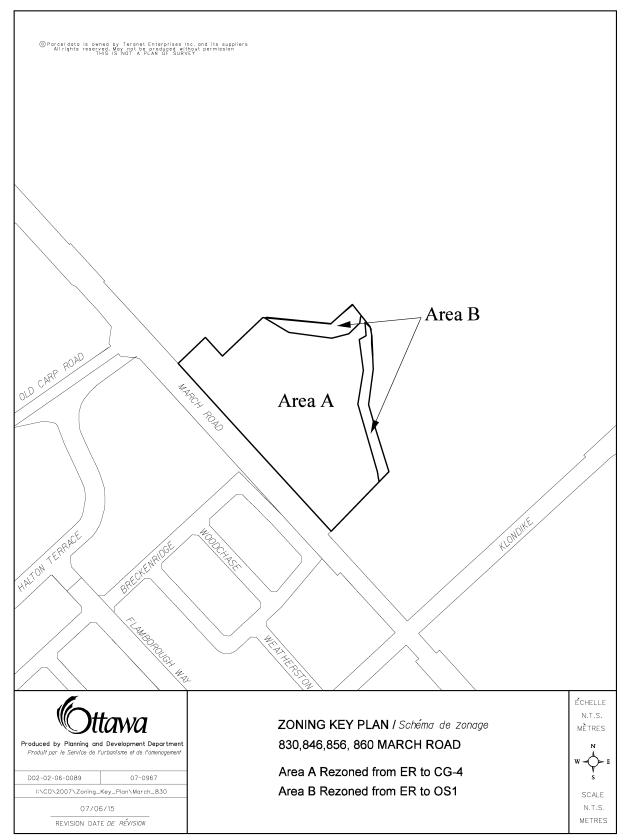
Document 4 Proposed Zoning Map
Document 5 Consultation Details
DISPOSITION
City Clerk’s Branch, Secretariat Services to
notify the owners (Trinity Development Group, 150 Isabella Street, Suite
610, Ottawa, ON K1S 1V7 and Klondike Developments Inc. c/o Cavanagh
Construction, 9094 Highway 7, R.R.#2, Ashton, ON K0A 1B0), applicant (William S. Holzman, Holzman Consultants Inc.,
1076 Castle Hill Crescent, Ottawa, ON K2C 2A8), OttawaScene.com, 174 Colonnade Road, Unit #33, Ottawa, ON K2E 7J5,
Ghislain Lamarche, Program Manager, Assessment, Financial Services Branch (Mail
Code: 26-76) of City Council’s
decision.
Planning, Transit and the Environment Department to prepare the by-law adopting the Official Plan Amendment, forward to Legal Services Branch, and undertake the statutory notification.
Legal Services Branch to forward the implementing by-law to City Council
LOCATION MAP Document
1

PROPOSED OFFICIAL PLAN AMENDMENT Document 2
|
|

Official Plan
Amendment Modifications du Plan
directeur
To the Official Plan of the City of Ottawa
Land use
Utilisation du sol
INDEX
THE STATEMENT OF COMPONENTS
PART A – THE PREAMBLE does not constitute part of the Amendment.
Purpose
Location
Basis
PART B – THE AMENDMENT consisting of the following text constitutes Amendment. No. __ to the City of Ottawa Official Plan (2003).
Introduction
Details of the Amendment
Implementation and Interpretation
Schedule A of Amendment __ – Official Plan of the City of Ottawa
PART A – THE PREAMBLE
Purpose
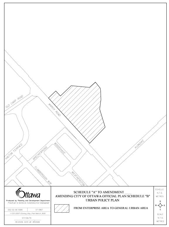
The purpose of this amendment is to amend Schedule B (Urban Policy Plan) from Enterprise Area to General Urban Area to permit a commercial development.
Location
The lands subject to this amendment are known municipally as 830, 846, 856, and 860 March Road, and described as Part of Lot 11, Concession 4, Geographic Township of March, and shown in Schedule A to this amendment. The lands are located east of March Road, south of Maxwell Bridge Road, west of the Shirley’s Brook corridor, and north of Klondike Road.
Basis
Background
The Official Plan amendment application proposes to amend the Official Plan designation on the site from Enterprise Area to General Urban Area.
The purpose of this application is to permit commercial development to occur on the subject lands, specifically to include uses that are not permitted in the current designation.
Context of Amendment
The Provincial Policy Statement (PPS) indicates that planning authorities may permit conversion of lands within employment areas to non-employment uses through a comprehensive review, only where it has been demonstrated that the land is not required for employment purposes over the long term and that there is a need for the conversion. As part of a 2005 City-initiated Official Plan Amendment, staff recommended that the designation of these lands be changed from Enterprise Area to General Urban Area. Staff concluded that the removal of these lands from the Enterprise Area would not impact the availability of employment lands throughout the City. Although City Council approved the majority of the Official Plan amendment, they did not approve the removal of these particular lands from the Enterprise Area designation for reasons unrelated to the staff rationale. Since that time, these lands and other adjacent Enterprise Area lands have not developed for employment uses, and staff continues to support the recommendation from the 2005 Official Plan amendment.
In addition, staff are currently preparing a City-wide Employment Strategy to examine the supply of employment land for the entire City. This strategy will help inform the 2008 Official Plan review, which will include recommendations for potential changes to the amount of lands designated as Employment and Enterprise Area. The employment lands that are proposed to be eliminated through the Official Plan amendment as shown on Schedule A will be accounted for during the comprehensive review of all employment lands throughout the City.
Enterprise Areas are intended to provide at least 2000 jobs. The site is isolated from other employment lands as it is entirely surrounded by lands designated as General Urban Area. The small size (3.8 hectares) of the subject lands indicates that it is not feasible to develop as a large-scale business park and it is therefore not practical for 2000 jobs to be located on the site. The proposed General Urban Area designation still allows for those uses envisioned in the Enterprise Area, in addition to residential and all commercial uses. As a result, the General Urban Area designation is better suited to the integration of a variety of uses, such as business, commercial, and residential.
The accompanying zoning by-law amendment is proposed to permit office uses, as well as some small-scale business uses, such as a custom workshop. The zoning has been created such that if office uses are provided on the site, increased maximum gross floor area will be permitted. This provision creates an incentive to provide at least 50% employment uses. The types of employment uses that are permitted in the proposed zoning are primarily office type uses that typically do not pose any significant compatibility issues with retail or residential uses. In addition to office uses, the recommended zoning permits medium- and high-density residential uses, such as stacked townhouses and apartments. These uses are only permitted on the second floor or above, and the maximum number of dwelling units is 150. Allowing office/business uses and medium- to high-density residential uses satisfies the intent of the Enterprise Area to integrate these uses.
Although the lands will be formally changed from the Enterprise Area to General Urban Area designation, the recommended implementing Zoning By-law amendment will maintain the majority of the intent of the Enterprise Area designation.
The proposed development will provide convenient services to the surrounding residential community as well as to those communities in nearby rural areas and business parks. The proposed change from Enterprise Area to General Urban Area designation will allow for a grocery store, and other retail uses, which will serve the local community. The General Urban Area designation is the most appropriate designation for the proposed development in order to direct the future development of compatible uses.
The site is separated from nearby residential development by March Road to the west, Maxwell Bridge Road to the north, and the Shirley’s Brook to the east. The undeveloped properties to the south are City-owned and the future of these lands has not yet been determined. The above streets and waterway corridors provide a transition between existing development and the proposed development. The recommended zoning restricts building height to approximately three storeys directly abutting a public street (March Road or Maxwell Bridge Road), which is consistent with the allowable building heights in the adjacent residential developments. Furthermore, the inclusion of residential uses as a permitted use on the subject site will allow for greater compatibility of uses. The recommended zoning also includes a provision encouraging those buildings adjacent to March Road or Maxwell Bridge Road to be oriented toward the street. The intent of this provision is to integrate the proposed development with the existing residential development and to facilitate pedestrian and cycling connections. As a result of the above, the proposed development is considered to be compatible with the surrounding forms of development.
March Road is designated as a Scenic Entry Route in the Official Plan. The Scenic Entry Route designation requires that attractive visual qualities of a development be incorporated into its design. The site is also adjacent to a City-owned designated heritage structure, known as the “March House”. The proposed development is intended to respect the heritage character of the area. A subsequent Site Plan Control application will be required to be approved prior to development of these lands, and this process will address compatibility and design issues such as lot configuration, street location and access, layout, aesthetics, heritage character, form, massing, servicing, pathway connections, heritage considerations, and buffering.
March Road is designated as an Arterial Road in the Official Plan and currently has a two-lane, rural cross-section. The detailed design stage for the widening of March Road to a minimum four-lane urban cross-section is currently underway and construction to follow. The proposed development is intended to be accessed via a fully controlled (signalized) intersection on March Road as well as two right-in/right-out intersections. In addition there will be one full intersection on Maxwell Bridge Road for site access. A Traffic Impact Study was submitted detailing the impact of the proposed development on the transportation network, and this study is acceptable to the City.
In summary, the removal of the Enterprise Area lands was previously recommended by staff and will be reviewed during the Employment Strategy to be completed in 2008 for the Official Plan comprehensive review. As well, the implementing zoning will permit additional retail uses, the development of which is best guided by the policies of the General Urban Area, though the recommended zoning maintains the majority of the intent of the Enterprise Area designation. The Official Plan amendment is consistent with the applicable policies in the Official Plan.
PART B – THE AMENDMENT
1. Introduction
All of this part of this document entitled Part B – The Amendment consisting of the following text and the attached Schedule A constitutes Amendment No. __ to the Official Plan of the City of Ottawa.
2. Details
The following changes are hereby made to the Official Plan of the City of Ottawa:
2.1
Volume 1, Schedule B, Urban Policy Plan is amended so
that the lands known municipally as 830,
846, 856, and 860 March Road, and described as Part of Lot 11,
Concession 4, Geographic Township of March, and as shown in Schedule A of this
amendment, are re-designated from “Enterprise
Area” to “General Urban Area”.
3. Implementation and Interpretation
Implementation and interpretation of this Amendment shall be in accordance with the policies of the City of Ottawa Official Plan (2003).
SCHEDULE A
DETAILS OF RECOMMENDED ZONING Document 3
- Schedule “A” of By-law Number 74-79 of the former City of Kanata is amended by deleting the lands known as 830, 846, 856, and 860 March Road, and shown as Area “A” and Area “B” on Document 5, and these lands are no longer subject to the provisions of By-law Number 74-79.
- Schedule “A” of By-law Number 164-93 of the former City of Kanata is amended by adding the lands known as 830, 846, 856, and 860 March Road and shown as Area “A” and Area “B” on Document 5, and the lands will be subject to the provisions of said By-law and zoned as follows:
Area “A”: CG-4 (Special Commercial General Zone)
Area “B”: OS1 (Open Space Type 1 Zone)
- The text of By-law Number 164-93 of the former City of Kanata is amended to delete Section 9(3)(d) and replace said Section with the following:
9(3)(d) CG-4
Notwithstanding the permitted uses and provisions of subsections 9(1) and 9(2) hereof to the contrary, the lands designated CG-4 on Schedule “A” shall be subject to the following:
(i) RESIDENTIAL USES:
The following residential uses are permitted:
a stacked townhouse dwelling;
an apartment dwelling;
a group home as per Section 5(1)(a);
a nursing home;
senior citizen dwelling units;
a home for the aged.
(ii)
ZONE
PROVISIONS
1. FRONT YARD DEPTH (minimum): 3.0m for any building with a side or
front wall facing toward the street; all other cases 6.0m. Within the CG-4 zone, the LOT LINE, FRONT
shall be the lot line adjacent March Road.
2. EXTERIOR SIDE YARD WIDTH (minimum): 3.0m for any building with a side
or front wall facing toward the street; all other cases 6.0m
3. INTERIOR SIDE YARD WIDTH (minimum): 3.0m
4. REAR YARD DEPTH (minimum): the greater of: 3.0m from the zone
boundary, or that distance recommended by a Geotechnical Report approved by the
Director, Planning Branch. Within the
CG-4 zone, the LOT LINE, REAR shall be the lot line adjacent to Shirley’s
Brook.
5. LOT COVERAGE (maximum): 50%
6. BUILDING HEIGHT (maximum):
(A) for that part of a building within 9 m of a STREET LINE: 11 m
(B) all other cases: 18 m
7. AMENITY AREA (Minimum): 20 square metres per dwelling unit, excluding
a nursing home, and a home for the aged.
8. GROSS FLOOR AREA (Maximum): 10,000 square metres for all
non-residential uses, except business office, financial office, and/or
professional office. Business office,
financial office, and/or professional office uses may have a maximum Gross
Floor Area of 20,000 square metres less the gross floor area utilized by other
non-residential uses.
(iii)
SPECIAL
ZONE REQUIREMENTS
1. All of the lands within the CG-4 zone are considered to be one lot
for zoning purposes, notwithstanding the lawful division of a lot pursuant to
the Planning Act, as amended, the Condominium Act, as amended, or any other
similar legislation.
2. The following residential uses may only be located on the second floor
of a building or above, and nothing in this by-law prohibits the entrance to
one of the residential uses from being located on the ground floor of a
building.
a stacked townhouse dwelling;
an apartment dwelling;
a group home;
senior citizen dwelling units.
3. A maximum of 150 residential dwelling units shall be permitted on the
lands zoned CG-4.
4. A landscaped strip with a minimum width of 3.0 metres is required
between any PARKING AREA and a LOT LINE, FRONT and LOT LINE, EXTERIOR SIDE.
(iv)
SPECIAL
PARKING PROVISIONS
Despite subsection 3(16), the parking rate for a SHOPPING CENTRE with
4500.0 square metres or more of net floor area shall be: 1 parking space per 21
square metres of net floor area.
PROPOSED ZONING MAP DOCUMENT 4
CONSULTATION DETAILS DOCUMENT
5
PUBLIC COMMENTS
SUMMARY OF PUBLIC INPUT
Comment:
Commercial uses were not anticipated when homeowners across March Road to the west bought their home originally. This could be a negative visual impact, and could create noise pollution.
Staff Response:
The subject site has been designated for urban development since 1997. The residential lands west of March Road have only developed in the last few years and some of which is still under construction. Visual and aesthetic issues will be addressed through the Site Plan Control process. March Road is an Arterial Road and is expected to generate significant traffic and noise. This was considered through the Subdivision process for the lands west of March Road.
Comment:
There are possible security issues between the buildings and Shirley’s Brook as this area has no surveillance.
Staff Response:
Issues with building orientation, lighting, fencing, and safety will be reviewed and addressed through the Site Plan Control process.
Comment:
This site should be considered for a City recreation complex.
Staff Response:
The City does not own the subject lands. The City’s Parks and Recreation Branch is currently undergoing a separate process to determine a location for a recreation complex.
Comment:
It is suggested that the applicant be required to submit a market analysis in support of its application. The study should demonstrate whether a need exists for additional commercial/retail lands in the area. As well, the study should indicate any impacts on potential future employment figures that were originally supported under the current designation, and how these opportunities will be secured within the remnant Enterprise lands. This market analysis should also take into account that there is General Urban Area designated and commercially zoned lands within close proximity to Trinity’s proposed development.
Staff Response:
The City does not require Market Analyses in support of development applications. Consideration was given to employment land availability during a 2005 staff-initiated Official Plan amendment and will be reviewed during the 2008 Official Plan comprehensive review.
COUNCILLORS’ COMMENTS
Former Ward 4 Councillor Peggy Feltmate indicated that there is an expectation of a “heritage” appearance to the proposed development.
Current Ward 4 Councillor Marianne Wilkinson is aware of the applications and the staff report.
Staff Response:
Issues with aesthetics and external design will be addressed through the Site Plan Control process. Staff intend to work with the applicant, Councillor, and community groups to find an appropriate design of the buildings that will incorporate the heritage elements.
COMMUNITY ORGANIZATION COMMENTS
March Rural Community Association Comments:
Although the City does not have the power to control the “look” of commercial development, I would hope that the City planners would put some emphasis that development would be most acceptable to the community around it if it reflected that this has always been considered the South March heritage district. The restored and enlarged South March schoolhouse certainly adds to this as hopefully the March House, once it is sold and restored. If the developer reflects or indeed builds on the existing heritage aspects of this area, it makes the area unique and special, returning to the developer significantly higher house values. The same occurred in Stittsville and indeed wherever this essential quality exists.
Staff response:
Issues with aesthetics and external design will be addressed through the Site Plan Control process. Staff intend to work with the applicant, Councillor, and community groups to find an appropriate design of the buildings that will incorporate the heritage elements.
ADVISORY COMMITTEE COMMENTS
Environmental Advisory Committee (EAC) Comments:
The EAC requested that a Traffic Impact Study be completed prior to approval.
Staff response:
A Traffic Impact Study was submitted and accepted by the City.