|
9. RICHMOND ROAD/WESTBORO COMMUNITY DESIGN PLAN AND
PROPOSED
ZONING BY-LAW AMENDMENT
PLAN DE CONCEPTION COMMUNAUTAIRE CHEMIN
RICHMOND/WESTBORO ET PROPOSITION DE MODIFICATION DES RÈGLEMENTS DE ZONAGE
|
Committee recommendationS as amended
That Council:
i.
Approve the Richmond Road/Westboro Community Design
Plan as amended (distributed separately and on file with the City Clerk
and shown as Document 2) as Council's direction on the future development of
the area.
ii.
Approve that the Community Design Plan as amended be
further amended so that 747 Richmond Road be included in the plan and limited
to a six storey (18 m) residential building.
iii.
Approve that the Richmond Road/Westboro Community
Design Plan as amended be recognized and conferred secondary plan status in
order to recognize the importance of the contributions of the community at
large in developing their community vision while respecting the call for
intensification within the Official Plan.
RecommandationS modifiÉes du Comité
Que le Conseil:
i.
Approuve
le plan de conception communautaire Chemin Richmond/Westboro tel que modifié
(distribué séparément et versé au dossier auprès du greffier de la Ville et
indiqué comme document 2), et que ce plan constitue l’orientation approuvée par le Conseil pour tout
aménagement futur du secteur.
ii.
Approuve une modification au Plan de conception communautaire tel que
modifié de façon à ce qu’il inclue la propriété située au 747, chemin Richmond
et que seul un immeuble résidentiel d’une hauteur maximale de six étages
(18 mètres) soit permis à cet endroit.
iii.
Approuve l’attribution du statut de plan secondaire au Plan de
conception communautaire du secteur du chemin Richmond-Westboro tel que modifié
afin de reconnaître l’importance de la contribution de la collectivité à
l’élaboration d’une vision communautaire tout en respectant la volonté
d’intensification exprimée dans le Plan officiel.
For the information of
council
The Planning and
Environment Committee also approved the following directions to staff:
That the Planning,
Transit and the Environment Department be directed to:
a) Initiate a
Transportation Management Implementation plan to examine in greater detail how
the 40 per cent transit modal share target can be achieved in the Community
Design Plan area and how the City and developers can implement the various
measures proposed (including potential funding mechanisms).
b)
Refer
the Development Review Mechanism model discussed in the Richmond Road/Westboro
Community Design Plan to the 2008 Official Plan Review's analysis of the
interpretation and implementation of the City's intensification objectives.
Pour la gouverne du Conseil
Le Comité de l’urbanisme et de
l environnement a également approuvé les directives suivantes :
Que le Service de l’urbanisme, du
transport en commun et de l’environnement :
a) Prépare un plan de mise en œuvre de la
gestion du transport afin d’examiner en profondeur la façon dont on pourrait
atteindre la cible de répartition modale du transport en commun de 40 pour cent
dans le secteur visé par le plan de conception communautaire et la manière dont
les promoteurs et la Ville pourraient appliquer les diverses mesures proposées
(dont les mécanismes éventuels de financement).
b) Étudie les mécanismes d’approbation
d’aménagement précisés dans le plan de conception communautaire Chemin
Richmond/Westboro en regard de l’analyse de l’examen du plan officiel de 2008
quant à l’interprétation et à la mise en œuvre des objectifs de la Ville en
matière d’intensification.
Documentation
1.
Deputy
City Manager's report Planning, Transit
and the Environment dated
11 June 2007 (ACS2007-PTE-POL-0023).
2. Extract of Draft Minutes, 26 June 2007.
Report
to/Rapport au :
Planning and Environment Committee
Comité de l'urbanisme et de
l'environnement
and Council / et au Conseil
11 June 2007 / le 11 June 2007
Submitted by/Soumis par : Nancy Schepers, Deputy City Manager/
Directrice municipale adjointe,
Planning, Transit and the Environment/Urbanisme, Transport en commun et
Environnement
Contact
Person/Personne ressource : Richard Kilstrom, Manager/Gestionnaire, Community
Planning and Design/Aménagement et conception communautaire, Planning
Branch/Direction de l’urbanisme
(613)
580-2424 x22653, richard.kilstrom@ottawa.ca
|
|
Ref N°: ACS2007-PTE-POL-0023
|
|
SUBJECT:
|
RICHMOND ROAD/WESTBORO COMMUNITY
DESIGN PLAN AND PROPOSED ZONING BY-LAW AMENDMENT
|
|
|
|
|
OBJET :
|
PLAN DE
CONCEPTION COMMUNAUTAIRE CHEMIN RICHMOND/WESTBORO ET PROPOSITION DE
MODIFICATION DES RÈGLEMENTS DE ZONAGE
|
REPORT RECOMMENDATION
1. That
Planning and Environment Committee recommend City Council:
a) Approve the Richmond Road/Westboro
Community Design Plan (distributed separately and on file with the City Clerk
and shown as Document 2) as Council's direction on the future development of
the area.
b) Approve an amendment to the former City
of Ottawa Zoning By-law, 1998 as shown on the location maps and detailed in
Document 3.
c) Rescind the January 25, 2006 City
Council motion that all rezoning and Official Plan amendment requests for the
Richmond Road/Westboro Community Design Plan study area be deferred until the
completion and approval by Council of the Community Design Plan process.
2. That
Planning and Environment Committee direct the Planning, Transit and the
Environment Department to:
a) Initiate a transportation management
implementation plan to examine in greater detail how the 40 per cent transit
modal share target can be achieved in the Community Design Plan area and how
the City and developers can implement the various measures proposed (including
potential funding mechanisms).
b) Refer the Development Review Mechanism
model discussed in the Richmond Road/Westboro Community Design Plan to the 2008
Official Plan Review's analysis of the interpretation and implementation of the
City's intensification objectives.
RECOMMANDATION DU RAPPORT
1. Que le Comité de
l’urbanisme et de l’environnement recommande au Conseil :
a) D’approuver
le plan
de conception communautaire Chemin Richmond/Westboro
(distribué séparément et versé au dossier auprès du greffier de la Ville et
indiqué comme document 2), et que ce plan constitue l’orientation approuvée par
le Conseil pour tout aménagement futur du secteur.
b) D’approuver
la modification du règlement de zonage de l’ancienne Ville d’Ottawa, 1998,
selon les indications du plan d’emplacement et les détails précisés dans le
document 3.
c) D’annuler
la motion du 25 janvier 2006 du Conseil municipal demandant de reporter toute
demande de modification des règlements de zonage et du plan officiel jusqu’à la
fin du processus du plan de conception communautaire Chemin Richmond/Westboro
et son approbation par le Conseil.
2. Que le Comité de l’urbanisme et de
l’environnement demande au Service de l’urbanisme, du
transport en commun et de l’environnement :
a) De
préparer un plan de mise en œuvre de la gestion du transport afin d’examiner en
profondeur la façon dont on pourrait atteindre la cible de répartition modale du
transport en commun de 40 pour cent dans le secteur visé par le plan de
conception communautaire et la manière dont les promoteurs et la Ville
pourraient appliquer les diverses mesures proposées
(dont les mécanismes éventuels de financement).
b) Étudier
les mécanismes d’approbation d’un aménagement précisés dans le plan de conception
communautaire Chemin Richmond/Westboro en regard de
l’analyse de l’examen du plan officiel de 2008 quant à l’interprétation et à la
mise en œuvre des objectifs de la Ville en matière d’intensification.
EXECUTIVE
SUMMARY
Assumptions and Analysis:
This
report recommends approval of the Richmond Road/Westboro Community Design Plan
(CDP) (Document 2) as Council's direction for the future development of the
Richmond Road/Westboro area. It provides a basis for several Zoning By-law
amendments detailed in Document 3 to implement the CDP recommendations.
The CDP's planning
strategy provides a framework for change that will see Richmond Road/Westboro
as it is today become the Richmond Road/Westboro of tomorrow. A unifying vision foresees an attractive and
liveable urban community, based on "green" principles and featuring a
wide mix of uses, enhanced green spaces, excellent transit service and
well-designed development that will enhance the area's diversity and
vibrancy. Compatible intensification
will occur primarily on appropriate sites along Richmond Road and Scott Street,
and adjacent to transitway stations, where Official Plan policy objectives
related to compatible development can be met.
The CDP area currently
contains about 5300 dwelling units.
Full built-out under the existing zoning could add 3200 units, a
potential 60 per cent increase. The CDP projects that close to 4000 new units
could be built in the CDP area, which is a moderate increase from the existing
zoning development potential.
The CDP also projects
that the current mix of residential and commercial uses on the Mainstreets will
continue, existing industrial uses will be replaced by residential/commercial
mixed use and that the Westboro Transitway Station area provides an opportunity
for increased office employment use.
The CDP proposes detailed building envelope and
infill development guidelines derived from a broad-based assessment of the
Westboro area to help achieve the Official Plan's compatibility principles for
intensification in established neighbourhoods. Notwithstanding these
principles, the Department recognizes that there may also be particular circumstances
as a result of unique property conditions or
development proposals, where a built form program different from that
recommended in the CDP may be acceptable.
Such situations will continue to be dealt with through site-specific
development review processes which will consider the broad objectives on which
the CDP is based, as well as applicable Official Plan policies, and, where
appropriate, will include an amendment to the CDP for the area.
A
greenspace network strategy is also proposed including improving pathway links
to the Ottawa River corridor, enhancement of Byron Tramway Park and
confirmation of the Rochester Field/Maplelawn and Atlantis-Selby sites as green
space.
A
transportation impact study was undertaken to examine the impact of full
build-out under the existing zoning and the proposed CDP recommendations. The traffic generated by full build-out
under the CDP proposals can be safely accommodated on the area road network. A fundamental concept of this would be very
strong transit supportive measures and enhanced pedestrian/cycling facilities
where applicable.
The
target is for a 40 per cent transit modal share (TMS) in the Richmond Road
corridor by 2021, an increase from the existing Transportation Master Plan
city-wide target of a 30 per cent TMS.
Financial Implications:
The
Richmond Road/Westboro CDP contains several initiatives and studies that are
follow-up measures to move forward the implementation of the Plan. When these
initiatives and studies come forward in future work programs, each will have
budget implications that will be addressed at that time.
Public Consultation/Input:
A
summary of the public consultation program, including the comments received, is
detailed in Document 4.
RÉSUMÉ
Hypothèses et analyse :
Dans ce rapport, on recommande
d’approuver le plan de conception communautaire Chemin Richmond/Westboro (PCC)
figurant au document 2, et que ce plan constitue l’orientation approuvée par le
Conseil pour tout aménagement futur du secteur. Il sert également de base à
plusieurs modifications des règlements de zonage, détaillées dans le document
3, afin de permettre la mise en œuvre des recommandations du pCC.
La stratégie de planification du PCC
constitue un cadre de changement grâce auquel le secteur Chemin
Richmond/Westboro pourra devenir le quartier Chemin Richmond/Westboro de
demain. La vision unificatrice proposée permettra de mettre en place une
collectivité urbaine attrayante et vivable, basée sur des principes «
écologiques » et offrant toutes sortes de possibilités, dont des espaces verts
améliorés, un excellent service de transport en commun et un aménagement bien
conçu pour améliorer la vitalité et la diversité du secteur. Des emplacements
appropriés, situés le long du chemin Richmond et de la rue Scott, à proximité
de stations du transitway, seront réservés pour une concentration résidentielle
compatible avec le quartier, dans la mesure où pourront être respectés les
objectifs politiques du plan officiel relatifs à la compatibilité des
aménagements.
Le secteur visé par le PCC contient
actuellement environ 5 300 unités d'habitation. En fin de projet, on
pourrait ajouter, avec le zonage actuel, 3 200 unités supplémentaires,
soit une hausse de 60 pour cent. Selon le PCC, on pourrait construire près de
4 000 nouvelles unités résidentielles dans le secteur du PCC, ce qui
constitue une hausse modérée par rapport au potentiel d'aménagement du zonage
actuel.
Toujours selon le PCC, la variété
actuelle d'utilisations résidentielles et commerciales sur les rues principales
se maintiendra, les utilisations industrielles existantes seront remplacées par
des utilisations polyvalentes résidentielles/commerciales et le secteur de la
station du transitway Westboro pourrait accueillir davantage d'utilisations
d'emploi administratif.
Le PCC propose une enveloppe de
construction détaillée et des lignes directrices applicables à l’aménagement
des terrains intercalaires, qui découlent d’une évaluation globale du secteur
Westboro, afin de respecter les principes de compatibilité du plan officiel
relatifs à l’intensification de la concentration résidentielle dans les
quartiers établis. Nonobstant ces principes, le Service reconnaît que, dans
certaines circonstances spéciales découlant de conditions foncières
particulières ou des propositions d’aménagement, il est possible d’accepter un
programme de construction différent de celui qui est recommandé dans le PCC. Ce
genre de situation continuera à être analysé dans le cadre du processus
d’approbation de l’aménagement des sites, qui prendra en compte les objectifs
généraux du PCC, ainsi que les politiques du plan officiel et, le cas échéant,
autorisera une modification du PCC du secteur.
On propose également une stratégie
des espaces verts avec amélioration des sentiers d’accès au couloir de la
rivière des Outaouais, du parc Byron Tramway et confirmation de la vocation
d’espace vert des sites de Rochester Field/Maplelawn et d’Atlantis-Selby.
On a entrepris une étude d’impact du
transport dans le cas de l’utilisation de tous les terrains à bâtir dans le
cadre des règlements de zonage actuels et en fonction des recommandations du
PCC. Le trafic engendré par la construction, sur tous les terrains, selon la
proposition du PCC, pourrait être absorbé en toute sécurité sur le réseau
routier du secteur. Le principe fondamental proposé ici est de prendre des
mesures très importantes de promotion du transport en commun et d’améliorer
l’infrastructure piétonnière/cyclable, le cas échéant. L'objectif de
répartition modale est de 40 pour cent dans le couloir du chemin Richmond d’ici
2021, une hausse par rapport à l'objectif actuel du Plan directeur des
transports pour l'ensemble de la ville, fixé à 30 pour cent.
Répercussions financières :
Le plan de conception communautaire
Chemin Richmond/Westboro mentionne plusieurs initiatives qui constituent des
mesures de suivi de sa mise en œuvre. Lorsque ces initiatives et ces études
apparaîtront dans le programme futur des travaux, elles seront assorties d’implications
financières qui devront être prises en compte à ce moment là.
Consultation publique/Commentaires :
Le document 4 propose un résumé du
programme de consultation publique, ainsi que les commentaires reçus
BACKGROUND
On
June 28, 2005 Planning and Environment Committee approved the terms of
reference for the Richmond Road/Westboro Community Design Plan (CDP). The planning study had been previously
requested by the Committee in response to three development applications along Richmond
Road. In addition, two Community Associations in the area requested that a CDP
study be undertaken in order to have a plan in place to guide future
development.
The
goal of the study was to develop a broad and integrated 20-year vision for the
Richmond Road/Westboro area in order to guide both private development and the
undertaking of public works. Following
the selection of an urban design consultant team headed by GGBB Consultants,
the study commenced in September 2005 and was completed in April 2007. A
transportation consultant (IBI Group) was also hired to undertake a
transportation impact analysis of the CDP recommendations.
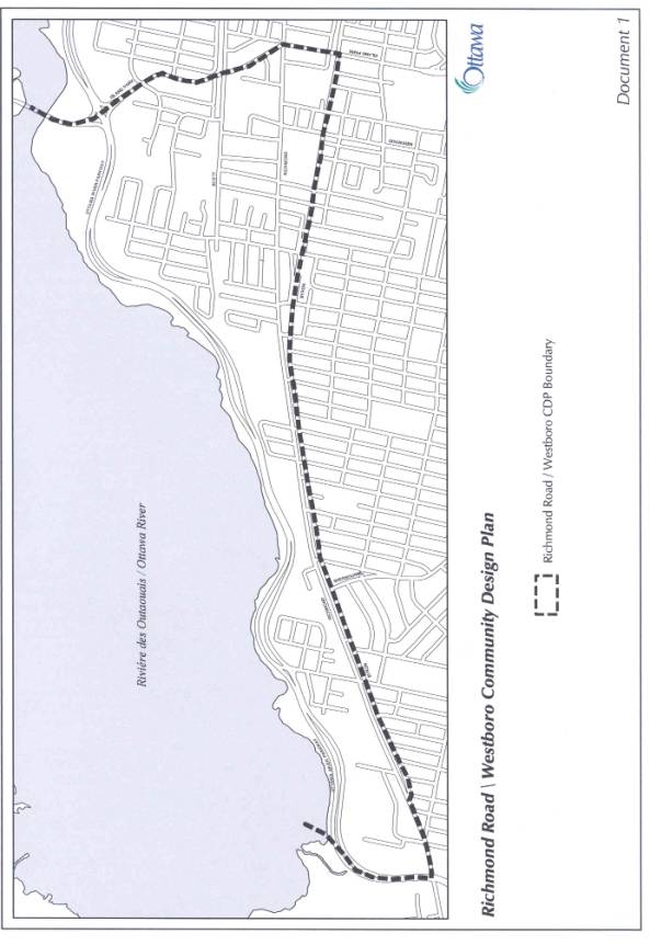
The
CDP boundaries as shown on the Location Map (Document 1), include Island Park
Drive on the east, the Ottawa River on the north, Ottawa River Parkway on the
west and Byron Avenue on the south, an area of 2.7 square kilometres. Two Traditional Mainstreets, Richmond Road,
running east-west along its entire length, and Scott Street, are included in
the planning area. The CDP encompasses part of, or is bounded by, several
neighbourhoods that are influenced by their proximity to Richmond Road,
including Westboro, Westboro Beach, Hampton-Iona, Highland Park, McKellar Park,
Woodroffe North and Woodpark. The large size of the planning area necessitated
that it be divided into nine different sectors to address the planning issues
of particular relevance to each sector.
DISCUSSION
RECOMMENDATION
1a)
Recommendation 1a) is to
approve the CDP as Council's direction
for the future development of the Richmond Road/Westboro area. It
provides a basis for the Zoning By-law amendment detailed in Document 2 to
implement the CDP recommendations related to built form and land use. While the CDP does set out specific provisions
for zoning changes, its primary purpose is to guide City Council, staff,
residents and property owners and developers in assessing the
appropriateness of development
proposals, including those development proposals where zoning changes are being
requested to address a unique site condition or development program .
The
CDP notes that it is the position of the Planning Advisory Committee (PAC) for
the study that the CDP should be added to the Official Plan as a secondary
plan. The Department does not support adding CDPs to the Official Plan at this
time in order to avoid the situation where Council needs to adopt two similar
amendments (to the Zoning By-law and to the secondary plan), when considering
development applications, when one amendment would be sufficient. With respect
to the Westboro CDP, development proposals may be submitted that are consistent
with the spirit and direction of the CDP, but that may not be consistent with
the specific built form direction provided in the CDP for the property in
question.
Staff
consider it best to have these proposals considered through a Zoning By-law
amendment process only, rather than also requiring an Official Plan
Amendment. Where such rezoning
proposals may be recommended for approval, an amendment to the
property-specific direction set out in the CDP would also be recommended. Staff also note that, with Bill 51 being
proclaimed on January 1st, 2007, Council-approved documents must be
considered by the Ontario Municipal Board (OMB) in its decisions, meaning that
the CDP will play a role at an OMB hearing whether it is a secondary plan or
not. Finally, CDPs approved by Council
to date have not been added to the Official Plan as new secondary plans. This
issue will be examined in the 2008 Official Plan Review, as one of the
"white paper" series that will be submitted to Committee and Council
this autumn.
Planning Strategy
The
CDP's planning strategy provides a framework for change that will see Richmond
Road/Westboro as it is today become the Richmond Road/Westboro of
tomorrow. A unifying vision foresees an
attractive and liveable urban community, based on "green" principles
and featuring a wide mix of uses, enhanced green spaces, excellent transit
service and well-designed development that enhance the area's diversity and
vibrancy. Compatible intensification
will occur on appropriate mainstreet sites along Richmond Road and Scott
Street, and adjacent to transitway stations, as directed by the Official Plan. This is not to say, however, that the compatibility
polices of the OP may not also be able to be met on other properties which have
uncommon site conditions or a unique development proposal. Such proposals will continue to be assessed
through the process of site-specific Zoning By-law amendment applications
which, if approved, could result in simultaneous amendments to the CDP for the
property in question.
Building
on the vision, three objectives for Richmond/Westboro govern the principles and
directions set out in the CDP. These objectives are:
- Encourage
intensification at appropriate locations that can achieve a human scale
and is compatible with the
existing residential community and the planned function for the site
and/or area;
- Preserve, enhance
and add to the green space network providing access to the Ottawa River
and also serving local community needs;
- Define the distinct
urban character of each sector of Richmond Road.
Based
on the vision, objectives and accompanying principles, the CDP includes a
greenspace network strategy and proposed streetscape improvements, a land use
and appropriate building scale strategy, and building envelope guidelines and
proposed zoning changes to help implement the CDP. It is also recognized that there may be site-specific
circumstances or unique development proposals on particular sites where
modifications to the CDP's specific built form and/or use directions applicable
to the property in question are appropriate and remain consistent with the
overall direction of the CDP and its underlying objectives. The CDP also features a 3D model to
demonstrate what the area could look like in the future.
The
CDP projects that close to 4000 new residential units could be built in the
planning area, if full build-out of every property with redevelopment potential
was to occur. This is a moderate
increase from the approximately 3200 units representing full build-out under
the existing zoning.
Much
of the potential increase in units is focused on existing industrially-zoned
properties that do not presently permit residential uses, and on lands adjacent
to the Westboro Transitway Station. Due to the size of these specific
properties, and with no anticipated redevelopment proposals, the CDP is not
recommending any zoning changes at this time.
Rezoning applications at the time of future redevelopment proposals will
provide an opportunity to examine individual site impacts in more detail, in
keeping with the CDP directives. Zoning
changes for properties elsewhere in the planning area are outlined in Document
3.
Building Envelope and Infill Development
Guidelines
The
CDP sets out detailed building envelope
and infill development guidelines on a broad basis to provide direction for achieving the Official Plan's compatibility principles for intensification
in established neighbourhoods. The purpose of the first set of guidelines is to promote redevelopment that will reinforce the existing character of
well-defined traditional mainstreet sections, such as Westboro Village and the
developing mainstreet between Tweedsmuir and Island Park Drive. In addition,
the guidelines aim to help create a renewed urban form in other sections of
Richmond Road and along Scott Street.
The second set of guidelines provides
more specific guidance for infill development at key areas/sites in each of the
planning area's nine sectors.
Greenspace
Network Strategy
Preserving,
enhancing and extending existing green spaces was one of the top planning issues raised by the
community. The CDP proposes a
greenspace network strategy, with a key element being to improve pathway links
to the Ottawa River Parkway corridor, which constitutes 80 per cent of the total green space in the planning area.
Other
components include:
- A restored
streetscape for Richmond Road/Byron Tramway Park. An extension westward of the existing
recreational pathway from Redwood Avenue to Richardson Avenue is proposed
to be included in the Community and Protective Services Department's 2008
Capital Works Program;
- Confirmation of the
National Capital Commission's (NCC)
Atlantis-Selby lands and Rochester Field/Maplelawn parcel as green
space. The means by which these
sites will be confirmed as green space is to be determined via discussions
among the City, the NCC and affected Community Associations as an
implementation measure of the CDP;
- Transformation of
key local streets providing links to the Ottawa River Parkway corridor
through tree planting, landscaping and the provision of minimum two-metre-sidewalks;
- Investment of cash-in-lieu of parkland funds
generated by development toward the improvement of existing park and
recreational facilities and creation of new parks in the planning area.
MAJOR
ISSUES
Intensification,
Compatibility and Building Heights
Intensification
on Richmond Road and other parts of the Planning Area was a contentious issue that emerged during the preparation in the
CDP. Ottawa's Official Plan calls for
intensification in the urban area over the next 20 years, with mainstreets such
as Richmond Road and lands along the Transitway and in proximity to transitway
stations being among the targeted areas for intensification. However, the
Official Plan also recognizes that infill development has to be compatible with
existing communities that are adjacent to mainstreets and the transitway, and
must be consistent with the planned function for an area. Much discussion and
debate centred on what could be considered compatible in terms of maximum
building heights and form. Area
residents wanted to keep building
heights lower because of concerns about the impacts of intensification on their adjacent neighbourhoods--loss of
privacy, shadowing, blocking of views, increase
in traffic volumes, lack of infrastructure capacity and green spaces,
overcrowded community facilities and schools, etc. Some developers and property
owners proposed higher buildings,
which they saw as implementing the City's intensification
policies for mainstreets.
The
CDP addresses these divergent views, in part through proposed changes to the
existing zoning discussed under Recommendation 1b) below, and by establishing
building envelope and infill development guidelines noted previously. In doing so, the Department recognizes that
unique site conditions and development proposals may be brought forward in the
future that are consistent with the overall direction of the CDP, but that may
not fit within the specific details of the CDP related to built form and/or use
on a particular site. When such
proposals are received, they will be assessed on their merits as is required
under the Planning Act, and in the context of the underlying principles and
objectives of the CDP, as well as the broader-based policy directions set out
in the OP which will continue to apply.
Where a development proposal requiring a Zoning By-law amendment is
deemed to be acceptable and appropriate, the CDP will be amended when
appropriate to reflect the necessary site-specific modifications related to
built form and/or land use.
Traffic
The
transportation impact of intensification in the Planning Area was another major
community issue to emerge during the study. A transportation impact study was
undertaken to examine the impact of full build-out under the existing zoning
and the proposed CDP recommendations.
The following is a summary of the study findings:
·
The traffic generated by full build-out under the CDP
proposals can be safely accommodated on the area road network. A fundamental
concept of this finding is very strong transit supportive measures and enhanced
pedestrian facilities where applicable;
·
It will not be necessary to widen Richmond Road to a
four-lane arterial throughout the corridor as a result of the CDP
recommendations;
·
In order to provide higher Levels of Service (LOS) at
key intersections, certain intersection modifications (additional turning lanes
and tapers) would be required under the present transit modal share (TMS). At
the preliminary design level, the modifications are feasible. However, with 40 per cent TMS in the
corridor, these intersection modifications would not be required. This finding
reinforces the importance of higher TMS to the City’s intensification goals,
and as such, 40 per cent should become the City’s target for future transit use
in this corridor, and be included in
the review and update of the Transportation Master Plan in 2008.
This
study is a new approach to transportation impact analysis and as outlined
Document 3, there is some public scepticism
that the 40 per cent target is realistic.
Consequently, following Council approval of the CDP, the Department will
initiate a transportation management implementation plan to examine in greater
detail how the 40 per cent target can be achieved and how the City and
developers can implement the various measures proposed, including their
potential funding mechanisms. This plan should be included as part of the
review and update of the TMP in 2008.
The measures that will
need to be examined by this transportation management implementation plan
include:
- Transit Priority
Measures, such as queue jumps (which will require some roadway
modifications), at key Richmond intersections (McEwen, New Orchard,
Woodroffe, and Fraser (one exists now at Richmond/Golden), and signal
priority at most intersections;
- Development of the
New Orchard area transitway station, which is included in the TMP. It is also possible that additional
stations in the corridor between Dominion Avenue and Lincoln Fields should
be developed as well;
- An intensification
of office employment uses in the Westboro Transitway Station area to
encourage transit use by commuters;
·
Enhancements to the pedestrian/cycling environment,
including two-metre minimum sidewalks and improved connections to transitway stations. Such enhancements could occur at the time of road rehabilitation
or reconstruction;
·
Transportation Impact Assessments (TIA) prepared for
new developments should propose physical, policy and planning measures that
will improve the pedestrian/cycling environment and improve transit operations,
as opposed to focusing on intersection modifications to increase vehicular
capacity.
·
The promotion of Transportation Demand Measures (TDM)
as a component of new developments. TIA studies prepared for new developments
should include an evaluation of the TMS at that time, as well as a TDM program
to help reduce car usage. The City has an existing TDM program that has
experienced reduced funding in recent years, and the Public Works and Services
Department is in the process of preparing a report to Transportation Committee
on this issue.
McKellar
Park/Highland Park/Westboro Area Traffic Management Plan Study
The
McKellar Park/Highland Park/Westboro Area Traffic Management Plan is examining
existing cut-through and other local traffic issues on the streets south of
Richmond Road.
A
community concern, shared by the PAC, is that cut-through traffic will increase
as a result of future intensification along Richmond Road. The PAC would have liked the CDP and the
area traffic management study to have also examined and proposed measures to address
such potential future increases.
With
regard to broadening the scope of the McKellar Park Highland Park/ Westboro
Area Traffic Management Plan, it is important to recognize that area traffic
management is primarily an operational process intended to address existing
traffic issues deemed to be of a significant nature (i.e., not easily resolved
through an operational review) within neighbourhoods. The typical
recommendations of these studies are various traffic management measures
(usually in the form of traffic calming) that are both warranted given current
conditions, and supported by the community given these conditions. Such measures, however, often have secondary
impacts, especially for area residents. Attempting to consider future issues
based on development potential that may or may not occur over the 20-year
perspective of the CDP, and implement measures based on these, would likely be
problematic for everyone involved. As well, the McKellar Park/Highland
Park/Westboro Area Traffic Management Plan is already well underway, and broadening
the scope would significantly delay the study, and lead to additional
frustrations for many of the people involved and concerned about today’s
problems.
Transportation
Impact Assessments Guidelines, approved by Council in 2006, now require
transportation impact assessment (TIA) studies, with varying degrees of
complexity, as part of individual site plan application approvals above a
certain size. The TIA evaluates, among other operational
requirements, the potential for community impacts resulting from the proposed
development, with a focus on the potential for neighbourhood infiltration by
site-generated traffic.
Infrastructure
An
analysis undertaken of the existing water, sanitary sewer and stormwater
management infrastructure in the
Planning Area concluded that the intensification proposed by the CDP can be
serviced by existing City infrastructure, with a few exceptions that will
require upgrading and/or minor extension at the time of redevelopment.
RECOMMENDATION
1b
Recommendation 1b) is to
approve an amendment to the former City of Ottawa Zoning By-law, 1998, as
detailed in Document 3, to implement the zoning recommendations of the
CDP. The CDP's zoning recommendations attempt to address both resident and
developer concerns noted above in terms of the Official Plan's intensification
and compatibility policies. However, this was done on a broader area-wide
basis without any detailed site-specific or potential project analysis. The
broad characteristics of each sector, the nature of the adjoining land use, and the general depth of lots were among the factors considered in
developing the recommendations. In some cases the CDP proposes to reduce
existing maximum building heights
because of the potential impacts on the adjacent low-rise neighbourhood, such
as the Woodroffe North area. The PAC
reached consensus on the zoning and
design for almost all of the key
sites that are potential candidates for intensification. Part of that process
included four PAC meetings with proponents for current or future development
proposals on particular sites.
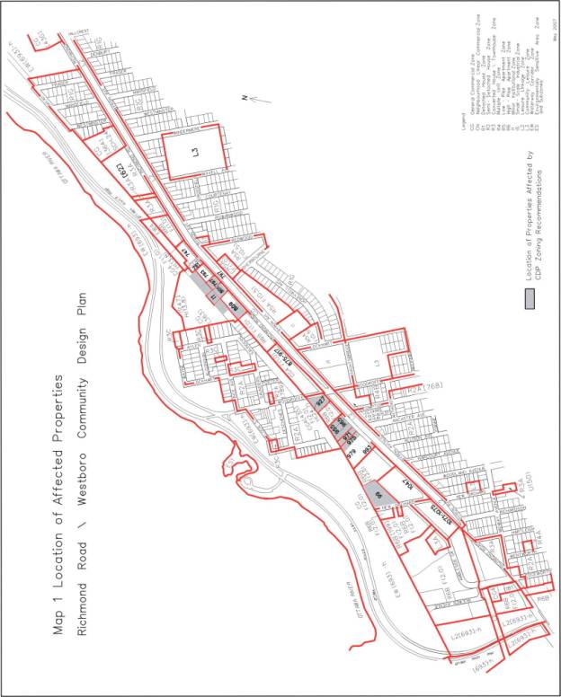
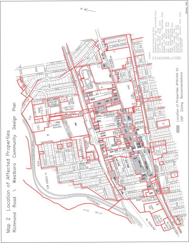
All
owners whose properties would be affected by the CDP's zoning recommendations,
if adopted by City Council, received a copy of the proposed zoning changes.
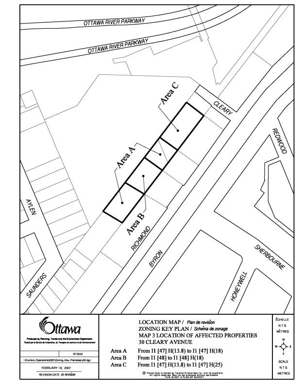
747
Richmond Road
Relative
to 747 Richmond Road (see Map 1 in Document 3), consensus could not be reached among staff, nearby property
owners, the PAC and the development
proponent. The residents of 727 Richmond Road (a five- storey condominium
immediately to the east) propose a maximum of six storeys as per the policies
for Traditional Mainstreets. This
position is supported by the PAC. The proponent has a rezoning application for
a 19- and 21-storey condominium development that, according to the applicant,
conforms to the City's intensification and compatibility policies, enhances the
pedestrian environment, has limited
impact on adjacent uses because of its relative isolation, and is in keeping
with the nearby 15-storey height limit for 793 Richmond approved by
Council and the OMB in 2005. Recently
the proponent revised their
application to a 15-storey height for the east half and a 18-storey height for
the west half.
Staff
considered both of the above positions, including the applicant’s recently
revised position, in an attempt to develop a compromise recommendation for the
CDP. That compromise was eight storeys
on the east half of the site to relate to the adjacent five-storey condominium,
and 12 storeys on the west half to relate to the approved 15-storey
condominium proposal west across Cleary Avenue. This was not, however, acceptable to the community nor to the
applicant, nor does staff consider it the best solution for this particular
site with its unique context.
Staff’s
view is that two narrow towers which leave a significant portion of the ground
plane open for views to the Ottawa River Parkway and to the river itself from
Richmond Road, is superior to a building of lesser height which fills the site
and perpetuates the lack of views to the river that currently exists with the
adjacent five-storey condominium, which covers well over 100 metres of its
Richmond Road frontage.
It
was therefore decided not to recommend a zoning change to 747 Richmond through
the CDP process, but rather to bring forward a separate report, with a
recommendation dealing specifically with the existing rezoning application
submitted for this property, for consideration by Planning and Economic
Development Committee (PEC) and Council.
PEC and Council will also give consideration to any amendment to the CDP
that would be required at the time that the rezoning for 747 Richmond is
considered.
The
issue that is central to the CDP discussion as reflected through the 747
Richmond Road proposal relates to attempting to achieve the different
objectives of different stakeholder groups through CDPs. The Official Plan clearly states that CDPs
should provide more detailed direction to advance the objectives of the OP
related to intensification and compatibility, which in turn suggests a more
policy-focused approach to CDPs. Communities experiencing development
pressures, while recognizing the role of the CDP, then look to CDPs as a means
to set in place detailed regulations and standards, which are achieved by
incorporating zoning changes into the CDP.
The development industry is seeking to ensure that CDPs provide clarity
with respect to how Official Plan objectives will be advanced within the
specific geographic areas where CDPs are to be prepared, and that these CDPs
not be used as a means to undertake area-wide zoning changes.
CDPs
are intended to establish the manner in which Official Plan policies will be
implemented at the community level for Mainstreets, Mixed-Use Centres, and
Developing Communities; and, in the urban area, CDPs often recommend zoning
amendments to reflect this additional level of detail. It is this level of detail that communities
seek, and that is of concern to the development industry in those cases where
the community maintains a view that there should be no site-specific zoning
changes considered once a CDP is prepared.
Staff
recognize that a CDP cannot ‘fine-tune”
the zoning for every property in its area because almost every site has its own
context and characteristics, and each site’s context and characteristics can
change over time as properties are consolidated or severed, and as new
development occurs nearby. Regardless
of how a site receives its zoning—through the new Comprehensive Zoning By-law
or via the implementation of a CDP—it is still possible that a development
proponent, working within the unique context of a specific site, may propose a
zoning amendment to accommodate a unique site context and/or an innovative
alternative development proposal that was not, and could not be, foreseen when
the existing zoning was established. Under the Planning Act, zoning amendment applications can be made
at any time, including during or at the conclusion of a CDP. The Act requires that Council make a
decision on each application based on its merits.
CDPs,
as a planning process, have been in use since 2003, and have established a
“track record” which can be evaluated in terms of what works well, what could
be improved, and what needs more attention.
The Official Plan Review’s “white paper” process provides this
opportunity. The “white paper” process,
by engaging all stakeholders, can facilitate this evaluation. One of the white
papers to be developed will deal specifically with the foregoing discussion
related to CDPs. It is expected through
this process that greater clarity will be established on the role and structure
of CDPs.
RECOMMENDATION 1c)
On
January 25, 2006 Council passed a motion that all rezoning and Official Plan amendment requests for the Richmond
Road/Westboro CDP study area be deferred until the completion and approval by
Council of the CDP process. As that
process is completed by the approval of this report, this motion can now be
rescinded.
RECOMMENDATION 2a)
Recommendation
2a) asks Committee to direct this Department to undertake a transportation
management implementation plan as discussed previously under Recommendation
1a), Major Issues.
RECOMMENDATION
2b)
During
the preparation of the CDP, the PAC proposed that "density caps" and
"triggers" were needed to monitor intensification in Richmond
Road/Westboro on an on-going basis.
They felt that a development
monitoring/review mechanism was necessary to determine if intensification was
having a negative impact on the community (e.g., impact on traffic and
infrastructure capacities, level of cut-through traffic, the transit modal split, among others).
At
a certain percentage increase in the number of residential units in the overall CDP area or sub-area, a review mechanism of these impacts
would be triggered to determine if the CDP's maximum development potential projections
needed to be adjusted, the zoning amended accordingly, and/or future community
infrastructure/facility needs addressed.
Note that the Richmond Road/Westboro CDP study examined transportation
and infrastructure capacities in terms of the CDP's and the existing zoning's
maximum growth potential projections, and these matters are addressed in the
CDP.
This
issue is not unique to the Richmond Road/Westboro area. It has been raised in
other CDP studies, and was most recently dealt with, on October 24, 2006, by
Planning and Environment Committee in the report on the Queensway Terrace North
Interim Control By-law study (ACS2006-PGM-POL-0069). The Committee directed staff to consider the Development Review
Mechanism model, proposed by the Queensway Terrace North Public Advisory
Committee, as part of addressing the interpretation and implementation of the
City's intensification objectives during the five-year review of the Official
Plan in 2008. The establishment of a development review mechanism to monitor
the impacts of intensification on established neighbourhoods is a city-wide
issue and is better addressed on a city-wide basis. The Richmond Road/Westboro CDP area should also be included in
the Official Plan review of intensification objectives.
ENVIRONMENTAL IMPLICATIONS
Implementation
of the Richmond Road/Westboro CDP will help enhance the planning area for
residents, shoppers and visitors alike.
It will lead to future streetscape improvements, enhance the pedestrian
environment, confirm green spaces for recreational activities, establish green
links to the Ottawa River corridor, and provide design guidance to address
local microclimate conditions potentially affected by future development.
CONSULTATION
The
Richmond Road/Westboro CDP entailed an extensive and detailed public
consultation program. This program
facilitated a creative process that saw initial ideas discussed, refined and
incorporated into the recommendations as the study progressed, so that the CDP
being recommended for approval, with the few exceptions discussed in this
report and the CDP, represents the community's planning vision for Richmond
Road/Westboro.
A
summary of the public consultation program, including the comments received
from the NCC to date, is detailed in Document 4
FINANCIAL IMPLICATIONS
The
Richmond Road/Westboro CDP contains several initiatives and studies that are
follow-up measures to move forward the implementation of the Plan. When these
initiatives and studies come forward in future work programs, each will have
budget implications that will be addressed at that time.
SUPPORTING DOCUMENTATION
Document
1 Location Map
Document 2 Richmond Road/Westboro CDP (on file with the City Clerk and
distributed separately).
Document
3 List of Zoning Bylaw Changes and
Location Maps
Document 4 Consultation Details
DISPOSITION
Planning,
Transit and the Environment Department, Planning Branch to:
·
Undertake the follow-up implementation measures outlined
in the CDP that are its responsibility;
·
Notify the Community and Protective Services Department
of Council's decision regarding the CDP recommendations, including: adding the
extension of the Byron Tramway Park pathway from Redwood Avenue to Richardson
Avenue to their 2007 Capital Works Program; confirming Atlantis-Selby and
Rochester Field as greenspace; directing cash-in-lieu of parkland funds
generated within the CDP area remain in the CDP area; and, examining the
programming of Churchill Seniors Centre as there is some potential to increase
capacity, with the caveat that parking is a major issue at the centre.
·
Prepare implementing by-laws;
·
Notify persons who made oral or written submissions at
Planning and Environment Committee and all persons and public bodies who
requested to be notified of the amendments;
·
Advertise the adoption of the amending Zoning By-laws.
Legal Services to forward implementing by-laws to
City Council.
RICHMOND ROAD/WESTBORO COMMUNITY DESIGN PLAN AND
PROPOSED ZONING BY-LAW AMENDMENT
PLAN DE CONCEPTION COMMUNAUTAIRE CHEMIN
RICHMOND/
WESTBORO ET PROPOSITION DE MODIFICATION DES
RÈGLEMENTS DE ZONAGE
ACS2007-PTE-POL-0023 BAY (7), KITCHISSIPPI (15)
Mr. Richard
Kilstrom, Manager, Community Planning and Design, introduced Mr. Michel Frojmovic, representing the
planning consulting firm Groupe Gautier, Biancamano, Bolduc and and Mr.
Bob Spicer, Planner. Mr. Frojmovik gave
a detailed presentation of the report by means of a PowerPoint presentation, a
copy of which is held on file with the City Clerk. He concluded his presentation by thanking Mr. Bob Spicer for all
his work on this plan, planning staff, the members of the Public Advisory
Committee and all those who participated in the process.
Kitchissippi
Ward Councillor Christine Leadman, spoke about the 40% transit modal split,
noting that, while this speaks to the area being able to manage the increase in
traffic and vehicles as a result of development, it puts forward no recommended
measures. She asked whether staff would
comment on this aspect. Mr. Kilstrom
said the report states that there is a Transportation Management Implementation
Plan (TMIP) to achieve the modal split, but gives no timeline at the moment. The Councillor questioned whether staff
believes it is responsible planning to move forward without this key element in
place. Mr. Kilstrom responded by
saying that, under the proposed zoning, 4000 units are being proposed and this
represents an increase of 800 units over the existing zoning. He pointed out that it would take a number
of years to achieve this increase whereas the work undertaken under the TMIP
would only take one or two years, and he did not see a conflict between the
two.
Mr. Mucsi, the
former Project Manager for the CDP’s Transportation Impact Study, explained the
process involved in arriving at a 40% transit modal split for the area. He noted that the current split was 6 to
14%, and called the proposed increase to 40%, a substantial one. Mr. Mucsi pointed out that transit modal
shares in other corridors are as follows:
·
Bank Street, 20/24 split;
·
Somerset and Bank, 50 / 55 % split;
·
Holland and Carling, 35 / 40% split.
Mr. Mucsi said
this illustrates that increases in transit modal share can be increased, with a
combination of courage and other measures to help achieve it.
Councillor
Leadman wanted to know whether there would be a “rolling cap” to ensure that
development doesn’t precede roadway capacity.
Mr. Bob Spicer clarified that this same matter came up as part of the
discussion related to Queensway Terrace North, and he confirmed this was also
part of the study: it looks at triggers and rolling caps and asks that this be
considered as part of the Official Plan review.
Councillor
Leadman asked what would be an acceptable level of intensification in light of
the fact the CDP’s recommendation of 4000 units represents a 75% increase in
the existing residential units.
Mr. Kilstrom said there
was no set number because what is an appropriate level here might not be
appropriate elsewhere. The plan was
developed to respect the current context in Westboro: there is no wholesale
rezoning throughout the neighbourhood.
Mr. Spicer added that the CDP is clear in identifying where residential
density should occur, specifically near the Westboro Transitway Station, where
there are employment opportunities and where some of the existing industrial
properties would become residential mixed use, some on Richmond Road, along
McRae Street and along Scott Street.
The Committee
Chair, Peter Hume said this was a very germane question, noting that, in
comparison to the projected growth in his ward, 800 sounded like a small
number. Mr. Frojmovic advised that this
arose many times during the course of the study. He expressed the belief there was no answer but that it was a
question of scale. He reiterated that
the focus of the CDP was not the entire neighbourhood, but one particular
stretch defined specifically because there is opportunity for development
thereon.
Councillor
Leadman asked for an explanation of why the property at 747 Richmond Road was
arbitrarily removed from the study and is being treated as a separate
property. She felt it was disrespectful
to the community, and to her Office, of it being removed without notification. Mr. Kilstrom disagreed that the site was
arbitrarily removed, noting that an application was made slightly before the
Westboro Study started and it was one of the reasons the study was needed,
because of the potential impact of what was being proposed at the time. There is an application on that site, it has
been in abeyance for two years, and it will come forward as the same kind of
zoning application the committee regularly receives. Staff concluded it was best to let that application come forward
on its own merits at the time. Councillor Leadman wanted to know why this is considered an
isolated site and how staff could support such a large number of cars coming
into this area. Mr. Kilstrom advised he
was not familiar with the details of the application but his understanding was
that the traffic study done for the proposed building to-date did not show
there would be a significant impact on Richmond Road.
Responding to
Councillor Leadman on infrastructure issues in the area, Mr. Michael Wildman
said an Infrastructure Capacity Study, the findings of which are summarized in
the CDP report, found a few localized areas identified as needing upgrades
which staff feel can be handled through the development process, along with
some stormwater management issues.
At this point,
the committee heard the following delegations:
Mr. John
Blatherwick, Woodpark Community Association, posed the following questions
and made the following comments:
Water:
Is the comment
in the CDP about there being adequate water supply for new development based on
a municipal servicing standard or does it refer to adequate municipal servicing
capacity? Will there be sufficient water pressure, sufficient fire suppression
pressure to handle 4000 new units?
Stormwater
Management:
There should be
a comprehensive stormwater management plan for Richmond Road before any
building permits are issued.
Sewers:
The CDP says the
West Nepean Collector has the capacity to accommodate sewer flow, including
storm events, but the capacity that counts is the capacity of the Robert O.
Pickard Environmental Centre, not that of the pipe. Has any money been put aside to expand and is there reserve
capacity at ROPEC?
Chair Hume
directed that the results of studies regarding these questions be made
available to Mr. Blatherwick for his review.
Mr. Stanislaw Cieslukowski advised he owns property on Churchill Avenue near
Richmond Road, and that he would like to see heights of 18 metres being
permitted, apartment buildings with commercial capacity on the lower levels and
people living on the upper floors.
Mr. Bruce
Bergen, President, McKellar Park Community Association, made a presentation
where he summarized the recommendations of the Public Advisory Committee as
follows:
a.
That the CDP be made a Secondary Plan to the current Official
Plan;
b.
That the development freeze not be rescinded until the CDP is
confirmed as a Secondary Plan;
c.
That the proposed zoning by-law, with the exception of 747
Richmond Road, be approved;
d.
That staff be instructed to implement a Transportation
Management Implementation Plan to achieve the 40% transit modal split and
prevent increased traffic on local streets;
e.
That staff be instructed to develop a Development Review
Mechanism based on the model described in the CDP;
f.
That Council initiate the process of acquiring key greenspace
areas as identified in the CDP.
Chair Hume
asked Mr. Bergen whether it was explained to him that a CDP couldn’t be
appealed by any of the development industry, whereas a Secondary Plan can be
appealed to the Ontario Municipal Board.
Mr. Bergen replied that the community understands this, and that it
wants to protect its vision of Richmond Road and Westboro. Bay Ward Councillor Alex Cullen added that
the is looking for a plan that would not only “have regard” but conform to a
secondary plan to which any application would also need to conform.
Ms. Janet
Bradley, representing Ashcroft Homes, said her client owns
four properties on the west side of Island Park and the north side of Richmond
Road. Ashcroft purchased a property
zoned for four storeys and was successful in having the Committee of Adjustment
approve a six-storey limit. In doing
so, the Committee of Adjustment noted this was an area in transition and in a
major site. The only appeal was settled
without the need for an OMB hearing.
Ms. Bradley pointed out that the CDP recommends there be only four
storeys on that strip, but does not recommend that the P&EC suggest a
zoning change today.
Ms. Bradley
wanted to know what a property owner was to take from the CDP. She quoted from Section Section 9.2 of the
CDP document, Proposed Zoning Changes, which states that:
“When the new
Comprehensive Zoning By-law is adopted in early 2008, new zoning
classifications and provisions will come into effect, incorporating the changes
recommended by the CDP”.
Further, Ms.
Bradley advised that Ashcroft Homes does not support four storeys on this part
of Richmond Road, as it believes that this is a good area for the City to look
at in terms of intensification and infill.
Ashcroft also believes that four storeys is too restrictive and has
demonstrated that six storeys can work well.
It is opposed to any part of the CDP that says the
Draft Zoning By-law “shall be changed” and to reducing the approved six storeys
down to four on its property.
Councillor
Leadman asked Ms. Bradley about her interpretation of what a CDP should
be. Ms. Bradley responded by saying
that CDPs are not recognized under the Planning Act as a means to
regulate the use of land in Ontario.
This doesn’t mean that municipalities can’t have other mechanisms to
assist them. This type of document is a
guide to future development, to ensure there are better streetscapes,
landscaping, and suggestions as to how to implement the Act. The CDP does say it is a guide, and relates
issues of concern to local communities.
The purpose of a CDP is to translate policies of the Official Plan to
the community level, but the O.P. must prevail. Ms. Bradley said there are serious concerns about the
implementation policies described on p. 69 of the CDP document. She expressed the view it would be improper
for the Committee and Council to approve a CDP with the provision contained in
Section 9.1, Status of the CDP. The Planning
Act states that the OP is the major planning document.
Responding to a
question from Chair Hume about the provisions of Bill 51, Mr. Tim Marc,
Senior Legal Counsel, Litigation and Administrative Law Division, said the Bill
states that the Board must “have regard” for policies adopted by Council, even
though they are not part of the O.P., and that there is a higher test of
conformity when measuring zoning by-laws.
Commenting at
the request of Councillor Leadman on a level of intensification that represents
75% of the current zoning, Ms. Bradley said she had found it surprising that,
in what she saw as key areas, there was actually almost no growth. She cited the example of Sector 2, where 747
Richmond Road is located, noting that the new zoning would actually permit
fewer units than the existing zoning.
She found it surprising that, in an era of intensification and infill
and in such an important part of the city, less growth would be permitted by
this document. She drew the Committee’s
attention to Table 3 in the CDP document, specifically for Sector 2 where the
number of residential units has decreased.
Ms. Bradley stated that intensification is a challenge, not only for
communities, but also for developers, and that a CDP that focuses on height was
not acceptable.
Mr. Ed Cuylits,
Chair of the Campus Planning Committee, First Unitarian Congregation of Ottawa,
spoke about the vagueness of the description of the guidelines specifically
that that these do not adequately address the issues of light, space, views and
privacy. The Public Advisory Committee
(PAC) has been promoting the concept that any building higher than three
storeys should not block the sunlight between adjacent buildings. In the CDP before the Committee, the First
Unitarian Congregation recommends that specific attention be paid to specific
design techniques, so that when you get beyond three storeys, the impact
becomes more significant. Mr. Cuylits
put forward two recommendations:
·
That the City initiate a review of design and planning processes under
the revised Planning Act, to allow a more comprehensive approach to urban
design;
·
That until new techniques have been developed, the CDP be a secondary
plan to the Official Plan to ensure a careful review of any requests for
exceptions to the CDP design standards.
Dan McLellan,
President, Carleton Condominium Corporation 260, 727 Richmond Road, spoke in
support of the observations and recommendations made by the previous
speakers. He focused on Recommendation
1B, the removal of 747 Richmond Road from CDP process, stating the
following:
The appropriate
Building Height for 747 Richmond Road: it was the unanimous
decision of the PAC that the maximum height should be 6 storeys; the
possibility of two buildings of 15 and 18 storeys, or even 8 and 12 storeys
would represent over-development of the site and would not meet the built form
guidelines of compatibility, harmony of scale and enhancement. An appropriate level of intensification can
be achieved by building out to the level of intensification.
Mr. McLellan
concluded by highlighting three recommendations from CCC 260:
·
Reject any zoning revision for 747 Richmond Road requesting a building
height beyond 6 storeys;
·
Request that staff re-instate the zoning recommendation for 747 Richmond
Road in the CDP and include this recommendation in the review and approval of
the CDP;
·
Request an Engineering Study of the sub-soil conditions at 747-727
Richmond Road be required as part of the development application for 747
Richmond.
Ms. Janet
Bradley, appearing on behalf of the owner of 747 Richmond Road said he has no
objection to his property being excluded from the CDP. She put forward the view it would be
inappropriate and unacceptable for the P&EC to now rezone this site since a
formal application has been made, it has to be processed, no notice was given
under the Planning Act for the application to be considered and this
should be done at another meeting. Ms.
Bradley further advised that the CDP recommendation that the site be zoned for
four storeys and that this be part of the Draft Comprehensive Zoning By-law was
inappropriate.
Mr. Ted Fobert,
representing the Torgan Group, provided background information of 747
Richmond Road, calling it a very unique site.
There is an existing plaza on the site, and the owner is a reputable
builder from the Toronto area. The lot
is 250 feet long. There is a
significant separation between the existing residential homes to the south and
the property.
What is being
suggested is that a massive building be laid on its side to cover up the
frontage so the building is in harmony with the rest of the community. Mr. Fobert said he did not believe this was
the best approach for this site, for future users or for the City. The surrounding area contains apartments of
more than seven storeys, apartment towers in the 3 to 6 storey range and lower
density areas. To the immediate left is
the Charlesford Development that has been approved: Cleary Avenue is the street
between that building and the two towers being proposed. The developer has agreed to push the
buildings to the eastern side of the lot, to minimize sun shadow impacts on
Unitarian House. The area enjoys
excellent transit service. A traffic
analysis done as part of the zoning application shows that the site can
accommodate the level of development without impact on the roadways. Mr. Fobert then gave a brief history of
Westboro, founding in the mid 1800s, noting it took almost 200 years to get to
5300 units, and the population has increased by 400 over a 30-year horizon. From 2001 to 2006, 180 units have been
added. Mr. Fobert posited this is not
devastating in terms of impact and that he does not believe the proposed
development at 747 Richmond Road needs to be seen in this light.
Responding to a
question from Councillor Leadman, Mr. Fobert reiterated that a full traffic
study was done and it shows that the traffic generated can be
accommodated. He also advised that
Cleary Avenue would be widened. In
reply to Chair Hume, Mr. Fobert said he supports Secondary Plan but he could
not support his one the way it was prepared, since it has become a regulatory
tool when it should be a guidance document.
Mr. Murray
Chown, representing Otto’s Subaru, said his client owns a number of properties
within the CDP area. He spoke about the
at 351 McRae, which the CDP recommends move to a commercial zone, saying his
client uses this property for used car sales and the recommended zoning would
remove the use “dealership” from the list of permitted uses, rendering his
client a non-conforming use. Mr. Chown
asked that, should the committee move forward with the rezoning of this
property, the use of “dealership” be retained.
Mr. Robert
Brocklebank, Federation of Citizens’ Associations, spoke in support of
making the CDP a secondary plan. He
went on to say that the FCA has expressed concerns about spot zonings in the
past, and believes that Councillors have very sound ideas when they speak in
general but often have great difficulty in reconciling their general comments
with some of their specific decisions.
Mr Brocklebank said the more status is given to the CDP, which is the
product of hundreds of volunteer hours, the more it will be taken
seriously. He added that, because some
communities have been discouraged about this process, it would become more
difficult to find people to work on them.
Mr. Doug Casey,
Charlesford Developments, expressed the view that the process had not
involved developers in the discussion.
He noted that developers live in neighbourhoods and are part of the
communities in which they live and thus may have ideas about what would be
beneficial to those communities.
Mr. Casey went
on to say that, next to his site is a one-storey dental office, whose owner
plans on being there for the next 15 to 20 years: this is one of the sites
identified as a six-storey site and this illustrates that some property owners
will disagree with the CDP. He pointed
out that building on Richmond Road does not mean that people will drive through
that neighbourhood: they will go down to the Parkway. Mr. Casey added that perception is sometimes worse than
reality. Speaking about the property
located at 727 Richmond Road, Mr. Casey called it a lost opportunity for the
community to have some vistas of the Parkway and the Ottawa River.
In reply to a
question from Councillor Leadman, Mr. Casey confirmed that the traffic study
done by DelCan for his project had looked at the traffic infiltration aspect,
as well as at the other factors commonly used, such as demographics.
Mr. Alan Cohen, advised he is
appearing on behalf of two clients whose properties were downzoned. Commenting on the CDP versus the secondary
plan, Mr. Cohen said that, if he had a CDP of which he was proud and with which
he was comfortable, he would have no hesitation in putting it in front of the
OMB or any other body to be considered, reviewed and determined.
Mr. Cohen went
on to say that his client, Domicile Developments, is an inner-city builder,
competing with much bigger builders to find land. Domicile has two parcels acquired for development over time:
these are located at 358, 382 and 369-373 Richmond Road. He indicated he is also appearing on behalf
of Frontline Financial, formerly the Ottawa Firefighters’ Union building on
Richmond Road.
Mr. Cohen
continued by saying that CDPs were originally conceived as studies done with
representatives of the community in an attempt to determine whether certain
neighbourhoods have distinctive or unique features and then to come forward
with designs to allow that community to develop over time, not to design
buildings nor to become a zoning by-law.
The process was “sold” to the development community when the 2003
Official Plan was being reviewed. At
the time, staff advised there would not be secondary plans and that the CDP
would eventually lead to a zoning by-law.
Mr. Cohen expressed the view that CDPs represent a derogation of
planning by the Committee, a stripping of the planning function from the
Department and conferring that planning function on the community. There is a group in the community deciding
which buildings can be of a certain height without regard to soil
characteristics, building costs, water tables.
Mr. Cohen said
he supported the right for the CDP to become a secondary plan because he has
hope that, in that form it will become policy.
In the alternative, he or someone else may go before the OMB to
determine whether or not it is correct planning
Mr. Cohen
concluded by saying that his clients’ properties have been downzoned, from a
current height of 24 metres under the zoning by-law to 18 metres in the CDP. No rationale is given for this change. He requested that the Committee consider
restoring his clients the previous height they enjoyed and consider taking away
the Floor Space Index. The clients are
prepared to accept setbacks and would get seven storeys, floor to ceiling, as
opposed to six storeys, if this were done.
Mr. Rod Lahey,
Architect, expressed the belief the CDP is seriously flawed in its relationship to
height and this will contribute to losing what the community wants to
accomplish, which is a strong Mainstreet on Richmond Road. Mr. Lahey presented slides of a recently
completed building, The Exchange, which he used to demonstrate that, even if a
building was more than six storeys high, it could blend in with the surrounding
structures through the use of careful design and materials. Mr. Lahey, a resident of Westboro for the
last 20 years, said he has heard nothing but compliments about this building,
and he could not understand how these kinds of buildings wouldn’t be of benefit
to Westboro. He emphasized the
importance of not comparing absolute height with perceived height. Mr. Lahey concluded his submission by saying
that the CDP would result in a lost opportunity to make Richmond Road a
spectacular area.
Chair Hume said
he believes that CDPs are more effective because they cannot be “eviscerated”
at the OMB. He suggested that this
become a secondary plan and, once the requisite hearings are done, a comparison
be made between the CDP and the secondary plan to determine which is more effective. Mr. Cohen responded by saying he welcomed
this test. He clarified that a CDP
should not be used to change the zoning by-law, because it cannot be appealed.
Committee
Discussion
Councillor
Peggy Feltmate introduced three Motions on behalf of the ward Councillor,
Christine Leadman.
Responding to a
question of clarification from Chair Hume, Mr. Marc confirmed that the CDP
couldn’t be converted to a secondary plan at this meeting. He added that it would be necessary to have
another meeting and to advertise this as a public meeting to consider an
Official Plan amendment (OPA). He
advised that, should this be the committee’s will, it should hold off on
enacting the zoning by-law until the OPA is enacted. To achieve this end, Mr. Marc recommended that Recommendations 1
a) and 1b) of the staff report be deferred, until such time as the OPA is
considered by Council.
Councillor
Leadman asked that the situation with development applications remain in place
until the process is completed. Mr.
Marc said that, should the motion be carried, it would be interpreted in a
fashion consistent with the Planning Act, and he suggested that the
Deputy City Manager, Ms. Schepers, bring back an OPA that has been considered
by Council. Ms. Schepers reminded
committee members that she has made a commitment to revisit the issue of CDPs as part of the review of the Official Plan.
Councillor
Cullen expressed the hope the committee would adopt all three motions. The community wants the CDP to be a
secondary plan, and to do things right.
The Councillor did not believe that making it a secondary plans means it
is carved in stone, as Opus are considered on an ongoing basis. He stated that the community was looking for
an extra element of support when dealing with zoning applications. Councillor Cullen expressed the view that,
rather than taking away from intensification, the community is honouring the
phrase about this process not altering the fundamental framework of a
community.
Councillor
Leadman pointed out that growth can’t be achieved without all the elements that
make it a success and currently, communities are reacting as opposed to being
participants. The reputable developers
that do good things suffer as a result of other projects that have harmed a
community. The community, through the
CDP, is saying it understands what the principles are, but would like to see
them captured in an inclusive package.
It wishes to create a level playing field where development can occur
and be compatible and community-friendly.
Councillor Gord
Hunter wondered if the residents of the Westboro seen on the photo on page 9 of
the CDP had said we didn’t want any development that altered the character of
the neighbourhood, using the same comments heard today, where would the 5000 housing
units be situated today. He said
communities are living entities that grow and evolve but they have to be kept
alive and change. The Councillor called
the suggestion of turning the CDP into a secondary plan one of the most
offensive ideas he has heard. He
pointed out that consultation was held on the understanding that the community
would provide guidance, then, at the last minute requesting it be turned into a
secondary plan. He said that, if this
was what the committee wanted to do, the community would have to go back and
start the consultation all over again.
This CDP is a disappointment: it has concentrated on height and in the
interest of protecting one part of the neighbourhood, it is putting buildings
on other streets such as Scott Street, where businesses and residences already
exist. Councillor Hunter said he would
not support changing this into a secondary plan, and nor would he support it as
a CDP. He advised that he had two minor
amendments to present, in response to Mr. Chown’s presentation.
Councillor
Diane Holmes said she was not surprised to see this plan come forward, as it
was clear the community would fight back in response to the spot zonings
approved by Committee and Council.
She stated that
intensification without adapting it to the community, including the provision
of the required social infrastructure, is not acceptable, and that this CDP
can’t be a surprise to anyone around the table.
Chair Hume,
called for a vote on the Feltmate Motions:
Moved by P. Feltmate
WHEREAS
Community Design Plans represent the desires of neighbourhoods and communities
in association with city staff to develop a unified vision to build a community
that can accommodate it’s growth or intensification while preserving the
established or desired character for the area.
AND
WHEREAS CDPs are the sole planning documents that are cited specifically in the
Official Plan as the way to translate the established vision for the city into
concrete measures that will make individual communities reflect the
comprehensive vision.
AND
WHEREAS CDPs recognition as a secondary plan is pivotal to its ability to be
utilized in the manner in which it was originally designed.
BE IT
RESOLVED THAT the Richmond Road/Westboro Community Design Plan be recognized
and conferred secondary plan status in order to recognize the importance of the
contributions of the community at large in developing their community vision
while respecting the call for intensification within the Official Plan.
CARRIED
` (G.
Hunter dissented)
Moved
by P. Feltmate
WHEREAS in
January 2006, City Council approved a rezoning freeze in order to maintain the
neighbourhoods existing character until the community design plan was completed
and approved;
AND
WHEREAS 747 Richmond road was the controversial site that generated Council to
act upon this freeze;
AND
WHEREAS no consensus was reached for 747 Richmond Rd between the community and
city staff that resulted in the decision to have no recommendations included in
the CDP report, as it will be dealt with in a separate report to Council;
AND
WHEREAS not having this pivotal site included undermines the importance and
intent of conducting a community design plan;
THEREFORE
BE IT RESOLVED THAT the Community Design Plan be amended so that 747 Richmond
Rd be included in the plan and limited to a six storey (18 m) residential
building.
CARRIED
(P.
Hume,
G.
Hunter dissented)
Councillor
Feltmate advised that the third Motion was withdrawn.
The committee
then considered the report recommendations, as amended by the foregoing.
That Planning and
Environment Committee recommend City Council:
i). Approve
the Richmond Road/Westboro Community Design Plan, as amended
(distributed separately and on file with the City Clerk and shown as Document
2) as Council's direction on the future development of the area.
ii.
Approve that the Community Design Plan as amended be
further amended so that 747 Richmond Road be included in the plan and limited
to a six storey (18 m) residential building.
iii)
Approve that the Richmond Road/Westboro Community
Design Plan as amended be recognized and conferred secondary plan status in
order to recognize the importance of the contributions of the community at
large in developing their community vision while respecting the call for intensification
within the Official Plan.
CARRIED as amended
2. That Planning and
Environment Committee direct the Planning, Transit and the Environment
Department to:
a) Initiate a transportation management implementation plan to
examine in greater detail how the 40 per cent transit modal share target can be
achieved in the Community Design Plan area and how the City and developers can
implement the various measures proposed (including potential funding
mechanisms).
b) Refer the Development Review Mechanism model discussed in
the Richmond Road/Westboro Community Design Plan to the 2008 Official Plan
Review's analysis of the interpretation and implementation of the City's
intensification objectives.
CARRIED
1.
That the property on the Front Half of 359-382 Richmond Road; Front half
of 408 Churchill have the height limit of 24 m.
2. That
the property at 351 McRae Street include an auto dealership as a permitted use.