|
2.
ZONING
- 613, 5585 AND 5601 HAZELDEAN ROAD ZONAGE - 613, 5585 ET 5601,
CHEMIN HAZELDEAN
|
Committee recommendationS
(This application
is not subject to Bill 51)
That Council approve Council approve the following amendments:
1. The land known as 613 Hazeldean Road be
deleted from the former Township of Goulbourn Zoning By-law 1007-62 zoning map
and the lands will no longer be subject to By-law 1007-62, and subsequently,
the said land be incorporated into the former Township of Goulbourn Zoning By-law
40-99 zoning map, zoned "CLR-2" (Community Level Retail, Exception
2), "CLR-3" (Community Level Retail, Exception 3) and
"CLR-3-h-f" (Community Level Retail, Exception 3, Holding, Flood
Fringe), and the lands will be subject to the provisions of By-law 40-99, and
2. The former Township of Goulbourn Zoning
By-law 40-99 be amended to rezone the lands known as 5585 and 5601 Hazeldean
Road from "A1" (Agriculture) to "I-X" (Institutional,
Exception X), "NEA-1" (Natural Environment Area, Exception 1),
"CLR-1" (Community Level Retail, Exception 1) and "CLR-2"
(Community Level Retail, Exception 2).
all
as shown on Document 1 and detailed in Document 3.
RecommandationS du Comité
(Cette demande n’est pas
assujettie au Projet de loi 51)
Que le Conseil
approuve les
modifications suivantes :
1. que
les propriétés sises au 613, chemin Hazeldean soient exclues du plan de zonage
relatif au Règlement de zonage no 1007‑62 de
l’ancien canton de Goulbourn et que ces propriétés ne soient plus visées par ce
règlement, pour s’intégrer ultérieurement au plan de zonage relatif au
Règlement de zonage 40‑99 de l’ancien canton de Goulbourn,
conformément aux désignations « CLR‑2 » (zone de commerces de
détail de quartier, exception 2), « CLR‑3 » (zone de
commerces de détail de quartier, exception 3) et « CLR‑3‑h‑f »
(zone de commerces de détail de quartier, exception 3, utilisation
différée, limite de crue), et qu’elles soient visées par les dispositions du
Règlement 40‑99;
2. que
le Règlement de zonage no 40‑99 de l’ancien canton
de Goulbourn soit modifié pour permettre le rezonage des propriétés sises au
5585 et au 5601, chemin Hazeldean, passant de la désignation « A1 »
(agriculture) aux désignations « I‑X » (zone institutionnelle,
exception X), « NEA‑1 » (zone écologique naturelle,
exception 1), « CLR‑1 » (zone de commerces de détail de
quartier, exception 1) et « CLR‑2 » (zone de commerces de
détail de quartier, exception 2);
conformément au contenu du
document 1 et aux détails du document 3.
Documentation
1.
Deputy
City Manager's report Planning, Transit
and the Environment dated
28 June 2007 (ACS2007-PTE-APR-0041).
Report to/Rapport au :
Planning and Environment Committee
Comité de l'urbanisme et de l'environnement
and Council / et au Conseil
Submitted by/Soumis par : Nancy Schepers, Deputy City Manager/
Directrice municipale adjointe
Planning, Transit and the Environment/ Urbanisme,
Transport en commun et Environnement
Contact
Person/Personne Ressource : Grant Lindsay, Manager / Gestionnaire,
Development Approvals / Approbation des demandes d'aménagement
(613)
580-2424, 13242 Grant.Lindsay@ottawa.ca
|
SUBJECT: |
ZONING - 613, 5585 and 5601 Hazeldean
Road (FILE NO. D02-02-05-0075) |
|
|
|
|
OBJET : |
REPORT RECOMMENDATION
That the Planning and Environment Committee recommend Council approve the following amendments:
1. The land known as 613 Hazeldean Road be
deleted from the former Township of Goulbourn Zoning By-law 1007-62 zoning map
and the lands will no longer be subject to By-law 1007-62, and subsequently,
the said land be incorporated into the former Township of Goulbourn Zoning
By-law 40-99 zoning map, zoned "CLR-2" (Community Level Retail,
Exception 2), "CLR-3" (Community Level Retail, Exception 3) and
"CLR-3-h-f" (Community Level Retail, Exception 3, Holding, Flood
Fringe), and the lands will be subject to the provisions of By-law 40-99, and
2. The former Township of Goulbourn Zoning
By-law 40-99 be amended to rezone the lands known as 5585 and 5601 Hazeldean
Road from "A1" (Agriculture) to "I-X" (Institutional,
Exception X), "NEA-1" (Natural Environment Area, Exception 1),
"CLR-1" (Community Level Retail, Exception 1) and "CLR-2"
(Community Level Retail, Exception 2).
all as shown on Document 1 and detailed in Document 3.
RECOMMANDATION DU RAPPORT
Que le Comité de l’urbanisme et de
l’environnement recommande au Conseil d’avaliser les modifications
suivantes :
1. que
les propriétés sises au 613, chemin Hazeldean soient exclues du plan de zonage
relatif au Règlement de zonage no 1007‑62 de
l’ancien canton de Goulbourn et que ces propriétés ne soient plus visées par ce
règlement, pour s’intégrer ultérieurement au plan de zonage relatif au
Règlement de zonage 40‑99 de l’ancien canton de Goulbourn,
conformément aux désignations « CLR‑2 » (zone de commerces de
détail de quartier, exception 2), « CLR‑3 » (zone de
commerces de détail de quartier, exception 3) et « CLR‑3‑h‑f »
(zone de commerces de détail de quartier, exception 3, utilisation
différée, limite de crue), et qu’elles soient visées par les dispositions du
Règlement 40‑99;
2. que
le Règlement de zonage no 40‑99 de l’ancien canton
de Goulbourn soit modifié pour permettre le rezonage des propriétés sises au
5585 et au 5601, chemin Hazeldean, passant de la désignation « A1 »
(agriculture) aux désignations « I‑X » (zone institutionnelle,
exception X), « NEA‑1 » (zone écologique naturelle,
exception 1), « CLR‑1 » (zone de commerces de détail de
quartier, exception 1) et « CLR‑2 » (zone de commerces de
détail de quartier, exception 2);
conformément
au contenu du document 1 et aux détails du document 3.
EXECUTIVE SUMMARY
Assumptions and Analysis:
The site is located on the north side of
Hazeldean Road and west of the Carp River within the Kanata West planning
area. The site is comprised of three
lots – 613, 5585 and 5601 Hazeldean Road.
The site has a combined lot area of 17 hectares and was previously used
for agricultural purposes. The site is
currently occupied by a farmhouse, agricultural buildings and a vegetable
stand. Hazeldean Tributary flows
diagonally through the site and joins the Carp River to the northeast of the
site. A small woodlot is located in the
western portion of the site.
The site is subject to a subdivision
application to create two new public streets, five commercial development
blocks, four blocks for a future rapid transit station and corridor on the west
side of the site, and two blocks for an open space corridor for the relocation
of Hazeldean Tributary, and six blocks for a road widening along Hazeldean
Road.
The applicant plans to develop the
site with a shopping centre containing approximately 37000 square metres of
retail and service commercial space. The
applicant has submitted a site plan application to permit the first phase of
development consisting of 8444 square metres of retail and service commercial
space in the western portion of the subdivision.
The recommendation is to approve amendments to the former Township of Goulbourn Zoning By-law Nos. 1007-62 and 40-99, to rezone the commercial blocks within the subdivision from an “A1” (Agriculture) zone and a “Rural” zone to new, site-specific “CLR-1” (Community Level Retail, Exception 1), “CLR-2” (Exception 2), “CLR-3” (Exception 3) and “CLR-3-h-f” (Exception 3, Holding, Flood Fringe) zones. The blocks for the transit corridor will be rezoned to a new, site-specific “I-X” (Institutional, Exception X) zone, and the blocks for the relocated Hazeldean Tributary corridor will be rezoned to an existing, site-specific “NEA-1” (Natural Environment Area, Exception 1) zone.
The subject property is
designated “Arterial Mainstreet” in the Official Plan and “Community Level
Retail” in the Kanata West Concept Plan.
The proposed zoning complies with these land use designations and
associated policies, and is consistent with the Urban Design Guidelines for the
Community Level Retail District and for development along Arterial
Mainstreets. The recommended zoning
will allow for the development of the site with a shopping centre containing
retail and service commercial space and a broad range of uses including offices
and apartment buildings to facilitate the development of a compact, mixed-use
node within walking distance of the future transit station planned at the
western edge of the property.
Financial Implications:
No costs are anticipated to be incurred by the City.
Public Consultation/Input:
A
public open house was held for the subject application and the concurrent
subdivision application on September 8, 2005.
Comments from the public included concerns with the following: traffic
impact on Hazeldean Road and the proposed Richcraft residential subdivision to
the north; addition of new traffic signals and driveways on Hazeldean Road and
their spacing; heritage significance of
the Grant House; lighting impact; the relocation of Hazeldean Tributary; market
support for retail and service commercial space and the impact on existing
stores; and the visual appearance and urban design of development adjacent to
Hazeldean Road.
RÉSUMÉ
Hypothèses et analyse :
Le site se trouve au
nord au nord du chemin
Hazeldean et à l’ouest de la rivière Carp, dans la zone de planification Kanata‑Ouest.
Il se compose de trois propriétés, soit : le 613, le 5585 et le 5601,
chemin Hazeldean. Au total, sa superficie est de 17 hectares, jadis
employées à des fins agricoles. Le site comporte actuellement une ferme, des
bâtiments d’exploitation agricole et un comptoir à légumes. De plus, le site
est traversé en diagonale par l’affluent Hazeldean qui se jette dans la rivière
Carp, située au nord‑est. Le site comporte dans sa partie ouest une
petite terre boisée.
Le site fait l’objet d’un plan de lotissement
qui prévoit deux nouvelles voies publiques, cinq quadrilatères d’aménagement
commercial, quatre quadrilatères destinés à l’aménagement d’une future station
de transport en commun rapide et d’un corridor du côté ouest du site, deux
quadrilatères formant un corridor à aire ouverte en vue de la dérivation de
l’affluent Hazeldean, de même que six quadrilatères servant à l’élargissement
du chemin Hazeldean.
Le
demandeur prévoit lotir le site d’un centre commercial d’une superficie
d’environ 37 000 m2 d’espaces de commerces de détail et de
services. Il a présenté une demande de plan d’implantation l’autorisant à
amorcer la première étape du lotissement, laquelle consiste en l’aménagement de
8 444 m2 d’espaces de commerces de détail et de services à
la partie ouest du lotissement.
La recommandation consiste à avaliser les
modifications aux règlements de zonage nos 1007‑62
et 40‑99 de l’ancien canton de Goulbourn, à rezoner les quadrilatères
commerciaux du lotissement, passant d’une zone « A1 » (agriculture)
et d’une zone « rurale » aux nouvelles zones particulières « CLR‑1 »
(zone de commerces de détail de quartier, exception 1), « CLR‑2 »
(exception 2), « CLR‑3 » (exception 3) et « CLR‑3‑h‑f »
(exception 3, utilisation différé, limite de crue). Les quadrilatères
servant à l’aménagement d’un corridor de transport en commun rapide seront
rezonés en fonction d’une nouvelle zone particulière « I‑X »
(zone institutionnelle, exception X), pendant que les quadrilatères du
corridor en vue de la dérivation de l’affluent Hazeldean feront l’objet d’un
rezonage en fonction de la zone particulière actuelle « NEA‑1 »
(zone écologique naturelle, exception 1).
La propriété porte la désignation
d’« artère principale » dans le Plan officiel et de « zone de
commerces de détail de quartier » dans le plan conceptuel de Kanata‑Ouest.
Le zonage proposé est conforme aux affectations du sol et aux politiques
connexes, selon les lignes directrices de l’urbanisme ayant trait au district
de zone de commerces de détail de quartier et à l’aménagement le long des
artères principales. Le zonage recommandé permettra de lotir le site d’un
centre commercial composé d’espaces de commerces de détail et de services. Il
donnera également lieu à une vaste gamme d’utilisations, dont la construction
d’immeubles à bureaux et résidentiels favorisant l’essor d’un carrefour compact
et mixte, à distance de marche de la station de transport en commun prévue à la
limite ouest de la propriété.
Répercussions financières :
Il est
prévu que la Ville n’aura pas de coûts à supporter.
Consultation publique / commentaires
:
Une
réunion publique a eu lieu au sujet de la demande en question et de la demande
concommittente de lotissement le 8 septembre 2005. Dans ses
commentaires, la population s’est dite préoccupée par les points
suivants : les répercussions de la circulation automobile sur le chemin
Hazeldean et le lotissement résidentiel Richcraft proposé dans la partie nord;
l’ajout d’une nouvelle signalisation routière et d’allées au chemin Hazeldean
de même que leurs dispositions; la valeur patrimoniale de la maison Grant;
les répercussions de l’éclairage; la dérivation de l’affluent Hazeldean; le
soutien du marché quant aux espaces de commerce de détail et de services et les
retombées sur le commerce actuel; de même que l’aspect visuel et l’urbanisme du
lotissement adjacent au chemin Hazeldean.
BACKGROUND
Site Context
The site is located on the north
side of Hazeldean Road and west of the Carp River within the Kanata West
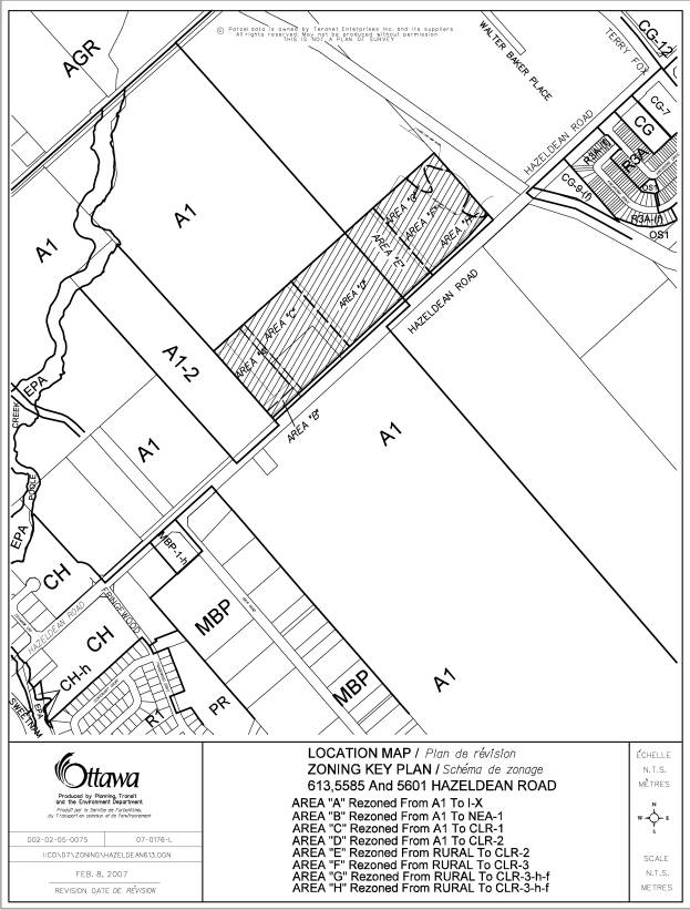
planning area, as shown in Document 1.
The western part of the property is located in the former Township of
Goulbourn and the eastern part is in the former City of Kanata.
The site is comprised of three lots
– 613, 5585 and 5601 Hazeldean Road.
The site has a combined lot area of 17 ha and was previously used for
agricultural purposes. The site is
currently occupied by a farmhouse, agricultural buildings and a vegetable
stand. Hazeldean Tributary flows
diagonally through the site and joins the Carp River to the northeast of the
site. A small woodlot is located in the
western portion of the site. A small
portion of the eastern end of the property is currently located within the Carp
River flood plain.
Immediately to the north of the
site, subdivision and Zoning By-law amendment applications have been submitted
to permit a residential subdivision with approximately 1200 to 1400 dwelling
units. The Carp River and the Kanata
Recreation Complex are located to the east of the site. A golf driving range and agricultural uses are
located to the south and are included in the planning area for the Fernbank Community
Design Plan. To the west are lands that
are subject to subdivision and Zoning By-law amendment applications to permit a
shopping centre with a gross floor area of 30,000 square metres.
Development Proposal
The applicant plans to develop the
site with a shopping centre containing approximately 37000 square metres of
retail and service commercial space.
Concurrent Applications
The site
is subject to a subdivision application to create the following:
·
two
new public streets extending from Hazeldean Road to the subdivision proposed to
the north of the site
·
five
commercial development blocks
·
four
blocks for a future rapid transit station and corridor on the west side of the
site
·
two
blocks for an open space corridor for the relocation of Hazeldean Tributary
·
six
blocks for a road widening along Hazeldean Road including an additional
five-metre wide landscaped pathway corridor, which is to be transferred to the
City
The draft plan of subdivision is shown in Document 2.
The applicant has submitted a site plan application to permit the first phase of development consisting of approximately 8444 square metres of retail and service commercial space in the western portion of the subdivision.
5585 and 5601 Hazeldean Road, which are identified as Areas “A” to “D” in Document 1, are currently zoned “A1” (Agriculture) in the former Township of Goulbourn Zoning By-law No. 40-99. This zone permits a range of residential and non-residential uses including, but not limited to a single detached dwelling, a group home, a bed and breakfast establishment, a farm, a forestry use, a kennel and a riding horse establishment. 613 Hazeldean Road, which is identified as Areas “E” to “H” in Document 1, is zoned “Rural” in the former Township of Goulbourn Zoning By-law No. 1007-62.
The purpose of this application is
to rezone the site to a new “Community Level Retail” (CLR) zone. The requested zoning would permit a broad
range of commercial uses including, but not limited to, retail stores, large
retail warehouses, a supermarket, a department store, a home improvement store,
office uses, service commercial uses, an automotive service centre, and an
automotive car wash. The applicant is
also proposing several residential uses including apartment dwellings, homes
for the aged, and institutional accommodation.
The applicant is proposing site-specific zone provisions dealing with
issues such as building height, lot coverage, yards and parking requirements.
DISCUSSION
Official Plan
The Official Plan designates the subject
lands as “Arterial Mainstreet”. This
designation identifies areas that are planned to provide a mix of uses and have
the potential to evolve, over time, into compact, pedestrian-oriented and
transit-friendly places. Permitted uses
within the Arterial Mainstreet designation include retail and service
commercial uses, offices, residential, and institutional uses. New gas bars, service stations, automobile
sales, and drive-through facilities are permitted on Arterial Mainstreets and
will be evaluated on the basis of the Design Objectives and Principles in
Section 2.5.1, the applicable Council-approved design guidelines, and the
Compatibility policies set out in Section 4.11. Urban Design Guidelines for Development along Arterial
Mainstreets were approved by City Council in June 2006.
The proposed land uses are in keeping with the
Arterial Mainstreet designation. It is
noted that the applicant has requested zoning to allow an automotive service
centre and a car wash, but has not submitted any plans showing the proposed
location of these uses. Furthermore,
there have not been any plans or elevations submitted demonstrating how these
uses can be accommodated in accordance with the intent of the Urban Design
Guidelines for Gas Stations and for Development along Arterial Mainstreets, and
the Urban Design Guidelines in the Kanata West Concept Plan.
Until sufficient supporting information and a
planning rationale have been submitted for review, the Department recommends
that the site should not be zoned to permit an automotive service centre and
car wash.
Hazeldean Road is designated in the
Official Plan as an Arterial Road.
Currently, Hazeldean Road has a two-lane, rural cross-section. An Environmental Assessment has been
completed for the widening of Hazeldean Road to a four-lane, urban
cross-section between Terry Fox Drive and Carp Road. A future North-South Arterial is designated immediately to the
west of the site.
The Official Plan designates the
western portion of the site as part of a “Future Rapid Transit Corridor
(Alignment to be Defined)” that will extend from Kanata Centrum to Scotiabank
Place and then to Hazeldean Road. The
Transportation Master Plan identifies the western portion of the site as a
“Future Potential Transit Station”.
Kanata
West Concept Plan
The subject land is located within
Kanata West, which is identified in Annex 5 of the Official Plan as an area
subject to a Community Design Plan or Policy Plan approved by City
Council. Kanata West includes about 725
hectares of lands and is generally located north and south of Highway 417 in
the vicinity of the Palladium Drive interchange and the Huntmar Drive overpass. Hazeldean Road forms the southern boundary
of Kanata West.
Council
approved the Kanata West Concept Plan in March 2003. According to the Concept Plan, Kanata West is intended to be a
sustainable community in terms of the mix of uses and the form of development
and will provide a full complement of opportunities for people to live, work,
play and learn. The Concept Plan
provides for the accommodation of approximately 25000 jobs, 5000 residential
units and supporting retail all within a framework of natural corridors and
waterways. The mix of uses will include
office, residential, retail, institutional, entertainment and leisure uses.
The Kanata West Concept Plan
designates the lands on the north side of Hazeldean Road between the Carp River
and Fringewood Drive as “Community Level Retail”. This corridor has a length of approximately 1.4 kilometres, and
includes the subject lands, the proposed shopping centre to the west, and a
City-owned property located at the northeast corner of Fringewood Drive and
Hazeldean Road. The Community Level
Retail designation permits a broad mix of uses including personal and
community-serving uses, leisure and entertainment uses, retail and commercial
uses, institutional uses, residential uses, hotels, and bed and breakfast
establishments. The proposed retail and
service commercial uses comply with the intent of the Community Level Retail
designation.
The Concept Plan contains urban
design guidelines for the Community Level Retail district that address issues
such as the block pattern, parks and open space, the streetscape treatment, and
building siting and massing. The urban
design treatment for the development will be addressed through the proposed
zoning provisions, the conditions of draft plan approval for the concurrent
subdivision approval application, and the site plan approval process for each
development phase.
Details of Recommended Zoning
The proposed amendment will rezone
the commercial blocks within the subdivision from an “A1” (Agriculture) zone
and a “Rural” zone to new, site-specific “CLR-1” (Community Level Retail,
Exception 1), “CLR-2” (Exception 2), “CLR-3” (Exception 3) and “CLR-3-h-f”
(Exception 3, Holding, Flood Fringe) zones.
The blocks for the transit corridor will be rezoned to a new, site-specific
“I-X” (Institutional, Exception X) zone, and the blocks for the relocated
Hazeldean Tributary corridor will be rezoned to an existing, site-specific
“NEA-1” (Natural Environment Area, Exception 1) zone. The boundaries of the proposed zones are identified in Document
1. The details of the new zones are
contained in Document 3 and summarized below.
613 Hazeldean Road is currently zoned under the
former Township of Goulbourn Zoning By-law No. 1007-62. This By-law, passed in 1962, is inadequate
to regulate the proposed shopping centre development. It is proposed that the lands be repealed from By-law No. 1007-62
and added to the current Zoning By-law No. 40-99 for the former Township of
Goulbourn, which applies to 5585 and 5601 Hazeldean Road. All of the site would then be regulated
through Zoning By-law No. 40-99.
Institutional, Exception X, Zone
Area “A” shown in Document 1 corresponds with the subdivisions blocks intended for the future transit corridor and station. These blocks are proposed to be zoned “I-X” (Institutional, Exception X), which will restrict permitted uses to a rapid transit corridor, a rapid transit station, a park-and-ride facility, and accessory uses only. The site-specific provisions will treat all of the transit corridor and station blocks as one lot for zoning purposes, and there will be no minimum front yard and minimum landscaped open space requirements. In addition, a 10-metre landscape buffer will be required adjacent to a residential zone.
Natural Environment Area, Exception 1,
Zone
Area “B” shown in Document 1 identifies blocks for the relocated Hazeldean Tributary. This area is proposed to be zoned as “NEA-1” (Natural Environment Area, Exception 1). The “NEA‑1” zone is an existing zone that restricts uses to conservation and passive park uses only, and is suitable to protect the fish habitat that has been identified within the creek.
Part of the relocated Hazeldean
Tributary corridor is proposed to the north of the subdivision within a
30-metre wide corridor. The zoning for
this section of the relocated corridor will be addressed through a separate
Zoning By-law amendment application for the proposed residential subdivision to
the north of the subject lands.
Community Level Retail Zone
The proposed zoning will establish a new “CLR” (Community Level Retail) zone that will permit a broad mix of uses in keeping with the range of uses set out in the Arterial Mainstreet and Community Level Retail policies.
The permitted uses will include apartments and a large range of non-residential uses including, but not limited to a shopping centre, retail stores, restaurants, banks, offices, clinics, recreational establishments, automotive parts and accessories stores, and garden centres.
To facilitate the evolution of
Arterial Mainstreets into more compact, pedestrian-oriented and transit
friendly places, the Official Plan indicates that the Zoning By-law may define
the portion of the street frontage of an Arterial Mainstreet to be occupied by
buildings located at or set back minimally from the sidewalk. In this regard, the Urban Design Guidelines for Development along
Arterial Mainstreets state that new buildings should be set zero to three
metres back from the front property line and zero to three metres back from the
side property line for corner sites, in order to define the street edge and
provide space for pedestrian activities and landscaping. Similarly, the Urban Design Guidelines for the Community
Level Retail district indicate that stand-alone buildings should be located
close to front or side lot lines and should not be interrupted with
drive-through lanes. The proposed “CLR” zone specifies that for larger
lots with over 90 metres of frontage a minimum of 30 per cent of the lot
frontage shall be occupied by buildings within three metres of the front lot
line. A maximum setback of three metres is also
proposed for buildings located within 50 metres of the two public streets
proposed within the subdivision. An
exception is proposed to accommodate commercial patios or outdoor amenity areas
between the building and street line, where the maximum building setback is
increased to six metres from the street line.
The Official Plan supports building heights of up to eight storeys on Arterial Mainstreets, with taller buildings heights being considered near transit stations. The Urban Design Guidelines for the Community Level Retail district generally contemplate lower building heights of up to four storeys, but with taller buildings permitted in proximity to the future transit station. The proposed “CLR” zone will permit maximum building heights of 15 metres (approximately four storeys) in keeping with the latter design guidelines. A reduced building height of 11 metres is proposed within 20 metres of a residential zone. Site-specific provisions are proposed in the “CLR-1” and “CLR-2” zones to allow building heights of up to 35 metres (approximately 10 storeys), on lands that are within approximately 400 metres of the future Hazeldean Road transit station.
A minimum parking ratio of 3.4 spaces per 100 squares of gross floor area is proposed for a shopping centre use. This ratio is based on the parking requirements in the City’s Draft Comprehensive Zoning By-law.
The proposed zoning requires a minimum
three-metre wide landscape strip between a parking area or drive aisle and a
street line. A minimum 2.5-metre
landscape strip is required between a parking area or drive aisle and a side
lot line or a rear lot line. These provisions
are drawn from the Urban Design Guidelines for Development along Arterial
Mainstreets.
Community Level Retail Exception Zones
Three “CLR” (Community Level Retail) exception zones are proposed for the commercial development blocks identified in Document 1 as Areas “C” to “H”. These exception zones will treat each of the three commercial development areas as one lot for zoning purposes.
This will allow parking to be shared between adjacent development blocks and avoid the requirement for a landscape buffer strip along the shared lot lines.
Areas “C”, “D” and “E” are located within approximately 400 metres of the future Hazeldean Road rapid transit station. A maximum building height of 35 metres is proposed in the corresponding “CLR-1” and “CLR-2” exception zones to accommodate the potential for higher density development within walking distance of the future station.
A special provision has been added to the “CLR-1” exception zone to not require a landscape buffer strip adjacent to the north-south portion of the relocated Hazeldean Tributary corridor. This portion of the corridor has a width of 16 metres, and has received preliminary approval from the Department of Fisheries and Oceans, the Ministry of Natural Resources, Mississippi Valley Conservation and the City’s Environmental Sustainability Division. The corridor will be dedicated to the City as a condition of subdivision approval. As the corridor will also function as a landscape buffer, an additional landscape buffer is not required adjacent to the corridor.
Areas “G” and “H” shown in Document 1 are currently located within the Carp River regulatory flood plain. The Department recommends that these areas be zoned as “CLR-3-h-f” (Community Level Retail, Exception 4, Holding, Flood Fringe), which will restrict the permitted uses to conservation and passive park uses until the “h” holding symbol has been lifted.
There will be three conditions to lift the holding symbol:
1) The Minister of the Environment has approved the Carp River, Poole Creek and Feedmill Creek Restoration Class Environmental Assessment;
2) The Kanata West Landowners Group, or the City, has commenced the physical construction of Phase I of the Carp River restoration works between Richardson Side Road and Highway 417; and
3) Mississippi Valley Conservation has issued a permit under Section 28 of the Conservation Authorities Act to remove the lands zoned “CLR-3-h-f” from the Regulatory (1:100 year) Flood Plain of the Carp River.
After the holding symbol has been lifted, Areas “G” and “H” may be developed in accordance with the provisions of the “CLR-3-f” zone. The “f” suffix denotes a special flood fringe zone and requires that all permitted uses be flood proofed.
Conclusions
The subject property is designated “Arterial Mainstreet” in the Official Plan and “Community Level Retail” in the Kanata West Concept Plan. The proposed zoning complies with these land use designations and associated policies, and is consistent with the Urban Design Guidelines for the Community Level Retail District and for development along Arterial Mainstreets. The recommended Zoning By-law amendment will allow for the development of the site with a shopping centre containing approximately 37000 square metres of retail and service commercial space.
In addition, the proposed zoning will permit the future intensification of the site with a broad range of uses including offices and apartment buildings to facilitate the development of a compact, mixed-use node within walking distance of the future rapid transit station planned at the western edge of the property.
ENVIRONMENTAL IMPLICATIONS
Carp River Flood Plain
Areas “G” and “H” shown in Document
1 are located within the existing regulatory flood plain for the Carp
River. The Carp River, Poole Creek and
Feedmill Creek Restoration Class Environmental Assessment was completed in
2006. The preferred alternative
restoration approach for the Carp River includes a change to the channel
cross-section and plan. Recommendations
include narrowing and increasing the sinuosity of the low flow channel to a
more “natural” form, channel/corridor modifications, creation of fish habitat
ponds, riparian plantings and pedestrian pathways. The proposed channel modification would allow for development to
occur within Areas “G” and “H” based on the technical analysis that accompanied
the Class Environmental Assessment.
Two other Environmental Assessments
have been completed for Kanata West and were planned and integrated with the
Carp River, Poole Creek and Feedmill Creek Restoration Class Environmental
Assessment – the Kanata West Master Servicing and the Kanata West
Transportation Master Plan Environmental Assessments. Seven of the projects identified in the three Class Environmental
Assessments have received requests for Part II Orders under the Environmental Assessment Act, and
require approval from the Minister of the Environment. The Carp River restoration project is one of
the projects subject to the requests for Part II Orders.
The
Department recommends that Areas “G” and “H” be zoned as “CLR-3-h-f” (Community
Level Retail, Exception 3, Holding, Flood Fringe), which will restrict the
permitted uses to conservation and passive park uses until the holding symbol
has been lifted. The three conditions
to lift the holding symbol are described above in the Details of Recommended
Zoning section. In particular, the
lifting of the holding symbol is contingent on the Carp River restoration
project being approved by the Minister of the Environment. Furthermore, the “f” zoning suffix requires
that all permitted uses be flood proofed.
Hazeldean Tributary
Hazeldean Tributary is proposed to be relocated
to a 16-metre wide open space corridor to the south and east of the future
rapid transit station, and to a 30-metre wide corridor running east-west on the
Richcraft lands immediately north of the site.
The open space blocks are to be transferred to the City through the
conditions of draft plan approval.
Hazeldean Tributary is fish habitat.
The Department of Fisheries and Oceans has provided a letter of advice
concluding that the proposed creek relocation is adequate to protect fish and
fish habitat. The proposed works and
undertakings will not likely result in the harmful alteration, disruption or
destruction of fish habitat. Therefore,
an authorization from the Department of Fisheries and Oceans is not
necessary.
Prior to the relocation of the creek, including the filling of the original channel, the owner will be required to obtain a permit under Ontario Regulation 153/06 (Development, Interference with Wetlands, and Alterations to Shorelines and Watercourses) from Mississippi Valley Conservation. The relocated creek corridor is proposed to be rezoned to an “NEA-1” zone that restricts uses to conservation and passive park uses only.
CONSULTATION
Notice of this application was carried out in accordance with the City's Public Notification and Consultation Policy. The Ward Councillor is aware of this application and the staff recommendation. A public meeting was held on September 8, 2005, for the concurrent subdivision application.
Detailed responses to the
notification/circulation are provided in Document 4.
FINANCIAL IMPLICATIONS
APPLICATION PROCESS
TIMELINE STATUS
The application was not processed by the "On
Time Decision Date" established for the processing of Zoning By-law
amendments. Additional time was required to
address the following: the Hazeldean Tributary relocation; heritage issues
associated with the Grant House; the size of land required for the transit
station and the acquisition of the land by the City; servicing issues;
transportation impact issues; market impact issues; urban design; zoning
details; subdivision conditions; and related environmental assessments for
Kanata West including the Kanata West Road Network Environmental Study Report;
the Carp River, Poole Creek and Feedmill Creek Restoration Environmental
Assessment; and the Kanata West Master Servicing Study Environmental
Assessment.
SUPPORTING DOCUMENTATION
Document 1 Location
Map
Document 2 Draft
Plan of Subdivision
Document 3 Details
of Recommended Zoning
Document 4 Consultation Details
DISPOSITION
City Clerk’s Branch, Secretariat Services to
notify the owner, Shenkman Corporation (Attn: Kevin McCrann), 190 Lisgar
Street, Ottawa, ON K2P 0C4 (Attn: Kevin
McCrann), applicant, FoTenn Consultant (Attn: Miguel Tremblay), 223 McLeod
Street, Ottawa, ON K2P 0Z8, Signs.ca, 866 Campbell Avenue, Ottawa, ON K2A 2C5,
Ghislain Lamarche, Program Manager, Assessment, Financial Services Branch (Mail
Code: 26-76) of City Council’s
decision.
Planning, Transit and the Environment
Department to prepare the implementing by-law, forward to Legal Services Branch
and undertake the statutory notification.
Legal Services Branch to forward the
implementing by-law to City Council.
LOCATION MAP DOCUMENT
1
DRAFT PLAN OF SUBDIVISION DOCUMENT
2
DETAILS
OF RECOMMENDED ZONING DOCUMENT
3
1. Schedule “A” (Map 1 and Map 2) of By-law Number 40-99 of the former Township of Goulbourn is amended by rezoning the lands shown as Area “A”, Area “B”, Area “C” and Area “D” on Document 1 as follows:
a) Area “A” is rezoned from “A1” (Agriculture) to “I-X” (Institutional, Exception X)
b) Area “B” is rezoned from “A1” (Agriculture) to “NEA-1” (Natural Environment Area, Exception 1)
c) Area “C” is rezoned from “A1” (Agriculture) to “CLR-1” (Community Level Retail, Exception 1)
d) Area “D” is rezoned from “A1” (Agriculture) to “CLR-2” (Community Level Retail, Exception 2)
2. Schedule “A” of By-law Number 1007-62 of the former Township of Goulbourn is amended by deleting the lands shown as Area “E”, Area “F”, Area “G” and Area “H” on Document 1, and these lands are no longer subject to the provisions of By-law Number 1007-62.
3. Schedule “A” (Map 1 and Map 2) of By-law Number 40-99 of the former Township of Goulbourn is amended by adding the lands shown as Area “E”, Area “F”, Area “G” and Area “H” on Document 1, and the lands will be subject to the provisions of the said By-law and zoned as follows:
a) Area “E” is zoned “CLR-2” (Community Level Retail, Exception 3)
b) Area “F” is zoned “CLR-3” (Community Level Retail, Exception 4)
c) Area “G” is zoned “CLR-3-h-f” (Community Level Retail, Exception 4, Holding, Flood Fringe)
d) Area “H” is zoned “CLR-3-h-f” (Community Level Retail, Exception 4, Holding, Flood Fringe)
4. The text of the former Township of Goulbourn Zoning By-law Number 40-99 shall be amended to add the following definition to Section 2, Definitions:
FLOOD PROOFED
Flood proofed means those established technical measures for buildings, structures or properties prone to flooding, which are implemented to reduce or eliminate flood damage. Flood proofed non-residential uses and alterations to existing non-conforming uses may incorporate wet passive measures.
5. The text of the former Township of Goulbourn Zoning By-law Number 40-99 shall be amended to add the following Subsection to Section 4, Zone Classification, immediately following Subsection (8), Temporary Zones:
(9) FLOOD
FRINGE ZONES
Where
a zone symbol is followed by a dash and an “f” (for example CLR-3-h-f), this
denotes a special zone. The permitted uses and the zone provisions for the
flood fringe zone shall be according to the zone represented by the zone symbol
as well as the following general provisions:
a) All permitted uses shall be flood proofed in accordance with the following provisions:
(i)
Any building and related major building services such
as mechanical or electrical services, shall be located at least 0.3 metres
above the regulatory flood level.
(ii)
All residential and non-residential uses shall be
flood proofed to 0.3 metres above the regulatory flood level.
6. The text of the former Township of Goulbourn Zoning By-law Number 40-99 shall be amended to delete subsection 3(14) and replace said subsection with the following:
3(14) LOTS DIVIDED INTO MORE THAN ONE ZONE
Where a LOT is divided into more than one ZONE, one of which is a Commercial or Industrial Zone, each such portion of the LOT shall be used in accordance with the provisions of this By-law for the ZONE where such portion of the LOT is located. Each such portion of the LOT shall be considered as a separate lot for the purpose of determining ZONE provisions.
(a) Notwithstanding the foregoing, where a LOT encompasses lands which are zoned EPA, such lands may be utilized to satisfy the ZONE provisions, provided that:
(i) approval of the relevant CONSERVATION AUTHORITY is secured, and
(ii) no part of the BUILDING or STRUCTURE is proposed in the EPA ZONE;
(b) Notwithstanding the foregoing, where a LOT encompasses lands which are zoned Flood Fringe (-f), such lands may be utilized to satisfy the ZONE provisions, provided that:
(i) the provisions of subsection 4(9) are satisfied; and
(ii) approval of the relevant CONSERVATION AUTHORITY is secured.
7. The text of the former Township of Goulbourn Zoning By-law Number 40-99 shall be amended to add the following within Section 12 (Institutional Zone):
a) I-X Zone
Despite anything to the contrary, the following applies to lands zoned “I-X”:
(i) Uses Permitted: The lands zoned “I-X” shall be used for no other purpose than for a rapid transit corridor, a rapid transit station, a park-and-ride facility, and accessory uses.
(ii) Zone provisions:
1. Yard, Front (minimum): no minimum
2. Landscaped Open Space (minimum): no minimum
3. All of the lands within the “I-X” zone are considered to be one lot for zoning purposes, notwithstanding the lawful division of a lot pursuant to the Planning Act, as amended, the Condominium Act, as amended, or any other similar legislation.
4. A Buffer Strip with a minimum width of 10 metres shall be provided along the full length of a Lot Line adjacent to a residential zone.
8. The text of the former Township of Goulbourn Zoning By-law Number 40-99 shall be amended to add the following section immediately following Section 16 (Mixed Use Commercial Zone):
SECTION 16A - COMMUNITY LEVEL RETAIL ZONE (CLR)
(1)
PERMITTED USES
No person shall within any “CLR” zone use any lot or erect, alter or use any building or structure for any purpose, except one or more of the following “CLR” uses, namely:
a) RESIDENTIAL USES:
· Dwelling, apartment
· Senior citizen apartment
b) NON-RESIDENTIAL USES:
· Amusement arcade
· Artist studio
· Assembly hall
· Automotive parts and accessories store
· Bake shop
· Bank
· Bed and breakfast establishment
· Building supply outlet
· Catering establishment
· Clinic
· Club, private
· Convenience store
· Day nursery
· Dry cleaning or laundry outlet
· Equipment rental establishment
· Funeral home
· Garden centre
· Hotel
· Laundromat
· Office, business
· Office, professional
· Parking lot
· Patio (Commercial)
· Place of worship
· Pub
· Recreational establishment
· Restaurant
· Restaurant, fast food
· Restaurant, take-out
· Retail store, which may also be engaged in manufacturing on the premises, provided such manufacturing is accessory to such retail business and the products manufactured are primarily for sale at retail on the premises
· Retirement lodge
· Secondhand shop
· School, other
· School, private
· Service shop, business
· Service shop, merchandise
· Service shop, personal
· Shopping centre, containing any of the uses listed in this zone
· Shopping plaza, containing any of the uses listed in this zone
· Small engine equipment sales
· Taxi stand
· Tourist establishment
· Veterinary clinic
(2)
ZONE PROVISIONS
No person shall within any “CLR” zone use any lot or erect, alter or use any building or structure except in accordance with the following provisions:
(a) Lot area: (minimum) 600 m²
(b) Lot frontage: (minimum) 18 m
(c) Yard, front: (minimum) 0 m
(d) Yard, exterior side: (minimum) 0 m
(e) Yard, interior side: (minimum) 0 m
(f) Yard, rear: (minimum) 10 m
(g) Lot Width Occupied by Buildings
(i) A minimum of 50% of the lot width within 3.0 metres of the Front Lot Line must be occupied by building walls if the lot is less than 90 metres wide;
(ii) A minimum of 30% of the lot width within 3.0 metres of the Front Lot Line must be occupied by building walls if the lot is 90 metres in width or wider;
(iii) If there are high voltage power lines present near the Front Lot Line, then the requirement in (i) and (ii) above is 5.0 metres instead of 3.0 metres;
(iv) If a patio or outdoor amenity area is located between a Building and the Front Lot Line, then the requirement in (i) and (ii) above is 6.0 metres instead of 3.0 metres; and
(v) In the case of phased development where all phases are shown on a site plan approved pursuant to Section 41 of the Planning Act, each phase itself does not have to meet the requirements of (i) and (ii) above, provided that those requirements are satisfied upon the completion of all phases of development.
(h) Buffer strip requirements:
Notwithstanding Subsection 3(3):
(i) a Buffer Strip with a minimum width of 10 metres shall be provided along the full length of any Lot Line adjacent to a residential zone;
(ii) a Buffer Strip with a minimum width of 3 metres shall be provided between a Street Line and a Parking Area or drive aisle;
(iii) a Buffer Strip with a minimum width of 2.5 metres shall be provided between a Side Lot Line and a Parking Area or drive aisle; and
(iv) a Buffer Strip with a minimum width of 5 metres shall be provided along the full length of a Rear Lot Line adjacent to a non-residential zone.
(i) Lot coverage: (maximum) 50%
(j) Building height: (maximum)
(i) Within 20 metres of a lot line abutting a residential zone: 11 m
(ii) In all other cases: 15 m
(k) Open Storage:
No open storage of goods or materials shall be permitted except in accordance with the following provisions:
(i) Every open storage use shall be accessory to the Use of the Building, Main on the Lot;
(ii) An open storage use shall not be permitted in a Yard, Front;
(iii) Every open storage use shall be screened from view from abutting Streets and abutting non-commercial Zones; and
(iv) No open storage use shall cover more than 20% of the Lot Area.
(l) Other provisions:
(i) The lot line adjacent to Hazeldean Road shall be deemed to be the Front Lot Line.
(ii) For any Building, or part of a Building, located within 50 metres of a Street Line other than a Front Lot Line, the nearest part of the Building must be located within 3 metres of the Street Line. Notwithstanding the foregoing, if a patio or outdoor amenity area is located between a Building and a Street Line, the nearest part of the Building must be located within 6 metres of the Street Line.
(iii) Notwithstanding Subsection 2(151), a Shopping Centre shall mean one or more buildings designed, developed and managed as a unit primarily for commercial uses and having the required off-street parking provided on the same lot.
(iv) Notwithstanding Subsection 3(16)(a)(ii), the parking rate for a Shopping Centre use shall be a minimum of 3.4 parking spaces per 100 square metres of gross floor area. Furthermore, the minimum number of required parking spaces shall be reduced by the number of on-street parking spaces that are located within 12 metres of the lot where the Shopping Centre is located.
(v) Notwithstanding Subsection 2(109), a parking space shall have a minimum width of 2.6 m.
(m) General provisions:
(i) In accordance with the provisions of Section 3 hereof, unless otherwise stated above.
(3)
SPECIAL
CLR ZONES
(a)
CLR-1 ZONE
All of the provisions of the “CLR” zone shall apply except for the following:
(i) All of the lands within the “CLR-1” zone are considered to be one lot for zoning purposes, notwithstanding the lawful division of a lot pursuant to the Planning Act, as amended, the Condominium Act, as amended, or any other similar legislation.
(ii) Notwithstanding the “CLR” zone provisions, a Landscape Buffer shall not be required along the westerly Side Lot Line located adjacent to the relocated Hazeldean Creek corridor.
(iii) Maximum building height: 35 m
(b) CLR-2 ZONE
All of the provisions of the “CLR” zone shall apply except for the following:
(i) All of the lands within the “CLR-2” zone are considered to be one lot for zoning purposes, notwithstanding the lawful division of a lot pursuant to the Planning Act, as amended, the Condominium Act, as amended, or any other similar legislation.
(ii) Maximum building height: 35 m
(c) CLR-3 ZONE
All of the provisions of the “CLR” zone shall apply except for the following:
(i) All of the lands within the “CLR-3” zone are considered to be one lot for zoning purposes, notwithstanding the lawful division of a lot pursuant to the Planning Act, as amended, the Condominium Act, as amended, or any other similar legislation.
(ii) The holding symbol “h” on lands zoned “CLR-3” identified on Schedule “A” may only be lifted when the following conditions have been fulfilled to the satisfaction of the Director, Planning:
a. The Minister of the Environment has approved the Carp River, Poole Creek and Feedmill Creek Class Environmental Assessment;
b. The Kanata West Owners Group, or the City, has commenced the physical construction of Phase I of the Carp River restoration works between Richardson Side Road and Highway 417; and
c. Mississippi Valley Conservation has issued a permit under Section 28 of the Conservation Authorities Act to remove the lands zoned “CLR-3-h-f” from the Regulatory (1:100 year) Flood Plain of the Carp River; and
prior to the lifting of the holding provision denoted by the “h” suffix, the lands zoned “CLR-3-h-f” shall be used for no other purpose than for a Conservation Use and/or a Passive Park.
(iii) The flood fringe zone symbol “f” on the said lands zoned “CLR-3” indicates that the lands are subject to the provisions of Subsection 4(9).
CONSULTATION DETAILS DOCUMENT
4
NOTIFICATION AND CONSULTATION PROCESS
Notification and public consultation
was undertaken in accordance with the Public Notification and Public
Consultation Policy approved by City Council for Zoning By-law amendments. One public meeting was also held in the
community on September 8, 2005, for the concurrent subdivision application.
SUMMARY OF PUBLIC INPUT
1)
Comment: There is a significant amount of
new development in the Hazeldean area already... this new development will add
significantly to an already bad traffic situation between Stittsville and
Kanata. Commuter traffic from
Stittsville has only two choices in the morning a) Carp Road, and b)
Hazeldean. I understand that a
subdivision has already been approved for the agricultural land between Maple
Grove Road and Hazeldean for 695 residences, as well as a new development
"Jackson Trails" in the quadrant between Hazeldean, Maple Grove and
west of John Woods St. Where will all
this traffic go?
Response: The trip distribution for individual
development applications such as the Jackson Trails subdivision, the Fairwinds
(Mattamy) subdivision, and the proposed shopping centre development are
addressed through individual transportation impact assessments. Trip distribution has also been addressed on
an area-wide basis through the transportation impact studies prepared for the
Hazeldean Road Widening Class Environmental Assessment and the Kanata West
Transportation Master Plan Class Environmental Assessment Report. These studies include road modification
recommendations to accommodate the projected growth in the area.
2)
Comment: This total amount of development
should require significant infrastructure investment... it appears inevitable
that local rate payers will be asked to pick up this cost of road widening,
traffic lights, schools, etc.
Response: The local roads, traffic lights, and
servicing required for the proposed shopping centre will be entirely at the
cost of the developer. Development
charges, which are collected from developers, finance the majority of
growth-related capital costs such as the planned widening of Hazeldean Road to
a four-lane cross-section from Terry Fox Drive to Carp Road, subject to the
criteria established in the Development Charge By-law. Arterial road projects are typically subject
to approximately 5% of the funding coming from general tax revenues.
3)
Comment: The environmental impact of
developing the limited amount of green or undeveloped agricultural land that
surrounds the communities of Stittsville and Kanata is unknown and on the
surface would appear to be negative. A
substantial amount of forest, marsh and open land in the area is disappearing
due to recent development.
This new development on the south
side of Hazeldean and along with the new development on the north side of the
road will irrevocably impact the environment and change the character of the
area. When one drives down Hazeldean
now you will quickly observe a rather ugly, crowded, eye-sore commercial signs
in the stretch between Terry Fox and Eagleson.
In the stretch between Kanata and Stittsville the road is tree-lined,
there are farmer's fields, forest, you can often see wildlife such as deer in
the surrounding fields, families of water fowl in the creek in the spring. This will be lost with the proposed
development. I do not want this green zone to look like the ugly
commercial/urban stretch of Hazeldean in Kanata. Where is the environmental impact study?
Response: The Kanata West area has been planned
comprehensively through the Kanata West Concept Plan. There have been four Environmental Assessments completed that
relate to the proposed development and the adjacent roads or natural features
including watercourses: 1) the Hazeldean Road Widening Class Environmental
Assessment, 2) the Carp River, Poole Creek and Feedmill Creek Restoration Class
Environmental Assessment, 3) the Kanata West Master Servicing Study Class
Environmental Assessment, and 4) the Kanata West Transportation Master Plan
Class Environmental Assessment. The
Environmental Assessments undertook an assessment of the natural and built
environment and planned the infrastructure to address any identified
environmental impacts. An Environmental
Assessment for the East-West Light Rail Transit project has also been
initiated, although work has been suspended.
Urban Design Guidelines have been
prepared for Arterial Mainstreets and for the Community Level Retail district
in the Kanata West Concept Plan. These
guidelines are intended to promote a comfortable pedestrian environment, to
create attractive streetscapes, to achieve a high-quality built form, and to
establish a strong street edge along Arterial Mainstreets. The application of these guidelines through
the site plan approval process will result in a more appealing development form
compared to earlier commercial corridors such as Hazeldean Road in Kanata.
4)
Comment:
Barn on the former Bradley Farm (closest to Carp River). Barns sub-committee of LACAC should be given
the opportunity to measure/photograph/document the barn before it is torn down
(perhaps also the farmhouse).
The next house that is currently
being occupied … this is the home of Robert H. Grant (1885), arguably
Stittsville’s most illustrious citizen of the past. The house (and its purported ghost) should be documented. Also new development should erect plaque in
his hour or make donation to Goulbourn Museum for display about Robert Grant,
Minister of Education (1919-1923).
Response: Heritage Staff conducted a site visit and
documented the Grant House in March 2006.
One of the conditions of draft plan approval requires the Owner to erect
a heritage plaque and/or interpretive panel on site.
5)
Comment: Concerns were received objecting
to the addition of numerous traffic signals on Hazeldean Road with minimal
spacing.
Response: Most of the proposed traffic signals on
Hazeldean Road between Carp Road and Terry Fox Drive were previously addressed
through the Hazeldean Road Widening Environmental Study Report. Two traffic signals are proposed on
Hazeldean Road to serve the proposed development and the Richcraft subdivision
to the north. The signals will be
spaced approximately 290 m apart. The
City’s transportation staff have advised that the proposed traffic signal spacing
is acceptable for an urban arterial road.
6)
Comment: Comments were provided regarding
light pollution.
Response: Through the site plan control process, all
light standards will be required to have sharp cut-off fixtures to minimize
glare, and light spillage may not exceed 0.5 foot-candles beyond the property
line.
7)
Comment: Will there be a protected area for
industry and employment in Kanata West?
Response: Yes, there are areas designated in the Kanata
West Concept Plan as “Prestige Business Park”, “Mixed Use”, “Intensive
Employment” and “High Profile Employment, Entertainment & Leisure Hub”
around Scotiabank Place that are intended to accommodate employment uses. The Concept Plan includes a target of about
25,000 jobs in the Kanata West area.
8)
Comment: How large will the grocery
component of the development be?
Response: A site plan application has been submitted to
permit the development of a food store with a gross floor area of 3753 square
metres.
9)
Comment: The development should not proceed
until Hazeldean Road is widened to four lanes.
Response: The timing for the widening of Hazeldean Road
to four lanes is subject to availability of funds through budget approval by
Council. If the reconstruction of
Hazeldean Road does not proceed in the near future, the owner may develop the
property by constructing interim road modifications on Hazeldean Road.
10)
Comment: It is environmentally wrong to
move the creek.
Response: The relocation of Hazeldean Tributary was
proposed in the Kanata West Concept Plan, which has been approved by City
Council. The relocated watercourse will
be designed applying natural channel design principles with minimum use of
engineered features such as culverts and retaining walls. The watercourse will remain open for most of
its length incorporating fisheries improvement works. The Department of Fisheries and Oceans has provided a letter of
advice concluding that the proposed creek relocation is adequate to protect
fish and fish habitat.
11)
Comment: A comment was made questioning the
need for the development, and the impact on current stores.
Response: The Kanata West Concept Plan requires the
submission of a market study for a Zoning By-law amendment application in the
Community Level Retail district to demonstrate that the market place can
support the proposed uses. Absolute
non-competition with the Kanata Town Centre or Stittsville Main Street need not
be shown, rather it should be demonstrated that similar opportunities for Main
Street or the Town Centre are not precluded.
The market study submitted with the application indicates that the
introduction of the shopping centre will contribute to servicing the future
residents of Kanata West as well as customers from surrounding residential
neighbourhoods in Kanata, Stittsville and beyond. The study concludes that the shopping centre is warranted based
on market demand and impact and will not preclude the further development of
the Kanata Town Centre or Stittsville Main Street.
12)
Comment: Will the landscaped pathway
corridor be used to widen Hazeldean Road in the future?
Response: Hazeldean Road has a protected right-of-way
width of 44.5 metres, which is sufficient to accommodate up to six vehicular
through-lanes (three lanes in each direction), turning lanes, bike lanes,
sidewalks, utilities and landscaping.
The additional five-metre wide landscaped pathway corridor is above and
beyond the protected right-of-way width, and would not be affected by the
potential expansion of Hazeldean Road to a six-lane cross-section.
13)
Comment: Would the buildings be
single-storey or multiple-storey?
Response: The applicant is currently proposing
single-storey buildings. However, the
proposed zoning will permit multiple-storey buildings to allow for more
compact, mixed-use development in the future.
14)
Comment: A stormwater management pond
should be provided on site.
Response: The applicant is proposing to provide an
interim stormwater management pond as part of the concurrent site plan
application. To accommodate the full
site development, stormwater is proposed to be conveyed to a centralized
stormwater management pond to be constructed west of the Carp River and south
of Maple Grove Road.
15)
Comment: Landscaping within the City
right-of-way should be low maintenance and drought resistant due to the lack of
City-funding for maintenance.
Response: If the developer proposes landscaping within
the City’s rights-of way, a maintenance and liability agreement would be
required for the owner to maintain the landscape material.
16)
Comment: There is about one million square
feet of retail space proposed on Hazeldean Road between Stittsville Main Street
and the Carp River, which represents serious traffic concerns.
Response: In total, there is about 850000 sq. ft. of commercial space currently proposed on Hazeldean Road between Stittsville Main Street and the Carp River. A transportation impact assessment will be required as a condition of subdivision approval for the proposed development. Additional transportation impact assessments may also be required to support the site plan applications for each development phase. The transportation impact assessments will include an assessment of existing traffic, background traffic, future traffic, and total traffic and will provide recommendations for any road modifications to accommodate existing and future traffic.
COUNCILLOR’S COMMENTS
Councillor Shad Qadri provided the following comments:
1)
Comment: I am in favour of this
development, however I would like it to remain as a community retail
development as indicated in the Kanata West Concept Plan and not changed to a
Highway / Main Street.
Response: Both the Arterial Mainstreet policies in the
Official Plan and the Community Level Retail policies in the Kanata West
Concept Plan apply to the site. The
lands are not proposed to be redesignated in the Kanata West Concept Plan, and
will remain as Community Level Retail.
The policies for the Arterial Mainstreet and Community Level Retail
designations are similar and complement each other.
2)
Comment: I am opposed to the three, lighted
entrances afforded this development. The traffic lights will affect traffic
flow on Hazeldean Road.
Response: Hazeldean Road is classified as an arterial
road in the Official Plan. Arterial
roads have a primary function to serve through traffic and a secondary function
to provide direct access to adjacent lands.
The subdivision includes two public streets that will intersect with
Hazeldean Road at signalized intersections.
The streets will provide access from Hazeldean Road to the proposed
development, and to the 1200 to 1400 dwelling units that are proposed in the
subdivision to the north. Immediately
to the west of the site is the North-South Arterial for Kanata West, which will
intersect Hazeldean Road at a signalized intersection. These three traffic signals will be spaced
approximately 290 metres apart. The
spacing from the future signalized intersection at Street No. 2 to the existing
signalized intersection at Terry Fox Drive is over 800 metres.
The proposed traffic signals at the
intersections of Street Nos. 1 and 2 with Hazeldean Road are necessary to
safely accommodate all modes of traffic and to provide an adequate level of
service at the intersections. The
proposed traffic signal spacing has been reviewed and approved by the City’s
transportation staff. The proposed
intersections balance the functions of an arterial road to serve through
traffic and to provide access to adjacent lands.
3)
Comment: I am not in favour of entrances
leading into the community travelling through shopping developments
Response: Access to the residential subdivision to the
north of the site is restricted by the Carp River on the east side of the
subdivision, and by Poole Creek and a future transit corridor on the west
side. The only arterial road frontage
is on Maple Grove where one signalized intersection is proposed for the
subdivision. Street Nos. 1 and 2 will
provide for two accesses from the residential subdivision through the subject
subdivision to Hazeldean Road. The street
connections are necessary to provide access from Hazeldean Road to the residential
subdivision and to accommodate transit service and emergency vehicle
access. The streets will also provide
for convenient access between the residential area and the Community Level
Retail district.
4)
Comment: The public accesses running through
this shopping centre will create safety issues and concerns, after development.
Response: The public streets will be developed in
accordance with City standards and will be designed to safely accommodate all
transportation modes. Development
within each of the commercial blocks will require site plan approval. The design and safety of the intersections
of the public streets with the site driveways will be reviewed later through
the site plan approval process.
5)
Comment: The traffic lights will affect
traffic flow on Hazeldean Road. Why are we widening Hazeldean Road if we are
going to place so many traffic lights, interruptions?
Response: The introduction of large urban areas, such
as Kanata West and the Fernbank Community Design Plan area, adjacent to an
arterial road will require that the road take on a much more urban character
and the most apparent aspect is the necessary spacing of intersections to allow
for safe access and egress within the new community (both residential and
commercial). The existing and future
projected speed and volume of traffic on Hazeldean allows the traffic analysts
to know that traffic signals will be warranted at most intersections. Additional signalized intersections reduce
the carrying capacity of the road over time, which is addressed by introducing
new parallel routes (lanes, roadways) by further expansion of the community.
The need and justification to widen Hazeldean
Road was addressed in the Hazeldean Road Widening Environmental Study
Report. Traffic volume projections
supported the need to widen Hazeldean Road to four lanes. The widening and upgrading of Hazeldean Road
will also provide an opportunity to improve the level of service for all modes
of transportation including walking, cycling, transit and driving. As previously discussed, the proposed
traffic signals are necessary to provide safe access to the subject subdivision
and the Richcraft subdivision to the north.
6)
Comment: Why as a city are we asking a
commercial development to have included public roads dissecting it's project?
Response: The public streets were requested to connect the Richcraft subdivision to the proposed Community Level Retail development and to Hazeldean Road.
COMMUNITY ORGANIZATION COMMENTS
Katimavik Hazeldean
Community Association
1) Comment: The zoning is in conformance with the Kanata West Concept Plan so the KHCA has no objections to the zoning proposed. We do however have concerns for the downstream traffic that will result from this development, and the expansion of Hazeldean to four lanes, on Hazeldean Road (Terry Fox to Eagleson). The KHCA supports and maintains the requirement for Huntmar to be completed before the mall opens.
Response: The extension of Huntmar Drive from Hazeldean Road to Maple Grove Road is currently under construction, and is expected to be opened in the summer of 2007. The comment regarding downstream traffic has been forwarded to the Department’s transportation staff for consideration as development applications come forward.
2) Comment: With the additional traffic it is becoming increasingly difficult to turn left from Edgewater and Young onto Hazeldean. We would strongly recommend these intersections continue to be monitored and considered for future traffic signals should traffic warrants, safety considerations or community support deem them advisable.
Response: This comment has been forwarded to the Department’s transportation coordinator in the Infrastructure Approval Division’s western unit for consideration as development applications come forward.
3) Comment: The KHCA is also concerned about comments at the meeting to reduce the number of traffic lights, adding roundabouts or by adding an internal road. This would only increase the number of vehicles queuing at intersections. It would also create a collector road that is not in keeping with the concept of the West Concept Plan. Roundabouts do not work on major four lane roads. Roundabouts also increase conflicts for cyclists and pedestrians.
Response: The applicant is not proposing any roundabouts on the proposed internal streets or on Hazeldean Road. However, Mattamy Homes is proposing a roundabout on Huntmar Road north of Poole Creek, and Richcraft Homes is also proposing an internal roundabout within the subdivision to the north.
Street No. 1 is proposed to be a collector road and will extend north through the Richcraft subdivision to Maple Grove Road. The collector road was required by the Transit Services Branch to provide for transit in the community prior to the implementation of the rapid transit corridor. The road network is generally in keeping with the intent of the Kanata West Concept Plan to provide a modified grid pattern integrating Residential Area “B” and the Community Level Retail district.
4) Comment: The KHCA would like to express the following concerning the concept site plan for the development:
a) The properties must be heavily screened or greened to maintain the appearance of the property from all angles. However security must not be sacrificed.
b) Eliminate the two right in, right out mid block accesses. These do not add to pedestrian and cyclist safety and are not needed.
c) Ensure that no left turns into east most entrance as it will conflict with golf range access (This is mostly a concern if the easterly block is built before the four lanes on Hazeldean road are completed).
d) Only one illuminated sign per block. A total of three signs. All signs must conform to signage size limitations.
e) Bicycle parking is required for each building and must be convenient to all store fronts. Cyclists should not have to walk farther than motorists to park their vehicles. The strip mall portion of each mall must have at least three bicycle parking locations.
f) The pathway in front of the future transit way will need to straightened and signalized when the transit station is installed.
Response:
a) Landscape planting will be required along all of the property edges. Final landscape designs will be approved through the site plan approval process for each development phase.
b) The developer is proposing three right-in, right-out driveways on Hazeldean Road as these are important to distribute vehicular traffic for a shopping centre development. The accesses are permitted under the City’s Private Approach By-law, and will be constructed in accordance with City standards to ensure pedestrian and cyclist safety.
c) The eastern access to the site is intended to be a right-in, right-out only access. The design of the access and potential conflicts with the golf course access would be addressed later during the site plan approval process for the eastern development block.
d) The pylon signage would be generally addressed through the Master Site Plan and the individual site plan applications for the development. It is anticipated that each development block will have one shared pylon sign along each street frontage. The specific quantity, area and location of signs are regulated through the City’s Comprehensive Sign By-law No. 2005-439 by the Building Services Branch.
e) The number and location of bicycle parking spaces will be determined through the site plan approval process for each development phase.
f) The design of the pathways will be coordinated to the extent possible with the future transit station as the design of the transit station progresses through the Environmental Assessment process.
5) Comment: The KHCA also has concerns regarding the pathways to be built by the city. Pathway security is paramount. The pathway beside Hazeldean Road will need adequate lighting for visibility and safety. Lighting of the pathway throughout the creek will also be required. Visibility and stop signage is required at all pathway crossings. Screening of the pathway must not detract from the security of the pathway.
Response: Lighting for the proposed sidewalk on Hazeldean Road will be provided in accordance with City standards for sidewalks on arterial roads. The Parks and Recreation Branch is not proposing lighting for the multi-use pathway within the Hazeldean Creek corridor. However, the feasibility of adding lighting to the pathway near the future Hazeldean Road rapid transit station would likely be considered at the time of the development of the station. The provision of stop signage at pathway crossings and the landscaping of the pathway corridor will be addressed during the preparation of the landscape plan for the relocated Hazeldean Creek corridor.
ADVISORY COMMITTEE COMMENTS
Local Architectural Conservation Advisory
Committee
1)
Comment: The Local Architectural
Conservation Advisory Committee
(LACAC), which is mandated to advise City Council on matters relating to
Ottawa's Heritage (pursuant to the Ontario Heritage Act), specifically on
issues of built heritage, including cultural heritage landscapes, reviewed the
noted application and submits the following comments:
LACAC strongly urges the City to
recognize the importance of the former Bradley Farm complex and the House of
Robert H. Grant located at 613 and 5601 Hazeldean Road respectively. These buildings are associated with persons
who have made significant contributions to the community's past and provincial
politics.
In the case of Grant's house, which
is currently in use and in fine condition, LACAC advises the City and Developer
to investigate every possibility to preserve the building in its current location. At the least, the house should be relocated
to a suitable site within the boundaries of its lot. Furthermore, as part of
the subdivision pre-design process, an earnest examination should be undertaken
into adaptive reuse options for this structure to serve the community at large,
the future development, as well as honour the memory of one of the most
illustrious citizens of this area's past.
In the case of the former Bradley
Farm, LACAC recommends a thorough documentation be conducted of the buildings
prior to their demolition to ensure that evidence of the previous land use will
perpetuate as a legacy to future generations.
LACAC has no objections to the
rezoning of the site from one type of land use to another per se BUT it is
conditional upon the retention of the 2-storey house at 5601 Hazeldean Road on
its lot and the proposed development to be designed around it as mentioned
above.
Response: In March 2006, Heritage staff completed an
examination of the interior of the house.
Most of the interior wood finishes had been removed from the house,
including the stair treads, stair railing, wainscoting and most of the
baseboards. There was extensive dry rot
of the original siding and possibly of the sill plate and elements of the
original balloon frame construction.
The original clapboard siding appeared to have deteriorated beyond the
point it could be repaired.
Following the site visit, Heritage
staff reviewed the historical significance, the architectural significance and
the contextual significance of the property.
The architectural significance of the building was diminished by the
fact the building was a common architectural type. Upon examination of the building fabric, Heritage staff found
that there was not enough of the original building materials to warrant
designation under the Heritage Act.
Unfortunately, only a 'shell' (in rather poor condition) of the original
building remained.
However, the building does have
historical significance. Heritage staff
recommended that the owner be required to install a plaque and/or panel on the
site. This has been addressed as a
condition of draft plan approval.
Heritage staff will provide the text for the plaque and/or panel in
French and English explaining Grant's historical significance and his
contributions to the Goulbourn community.
The Owner proceeded with the
demolition of the Grant House in April 2006.