|
2. ZONING
– 1476 AND 1488 CENTURY ROAD EAST AND 5758 FIRST LINE ROAD (FILE NO. D02-02-07-0079) ZONAGE – 1476 ET 1488, CHEMIN
CENTURY EST ET AU 5758, CHEMIN FIRST LINE
|
COMMITTEE recommendation
That Council approve an amendment to the former Township of
Rideau Zoning By-law to change the zoning of 1476 and 1488 Century Road
East and 5758 First Line Road as detailed in
Document 2 and as shown in Document 3.
Recommandation du Comité
Que
le Conseil approuve une modification au Règlement de zonage du Canton de Rideau
afin de changer la désignation de zonage des 1476 et 1488, chemin Century Est
et du 5758, chemin First Line, comme il est expliqué en détail dans le document
2 et indiqué dans le document 3.
DocumentatioN
1.
Deputy
City Manager's report Planning, Transit
and the Environment dated 5 October 2007 (ACS2007-PTE-APR-0190).
Report to/Rapport au:
Agriculture and Rural Affairs Committee
Comité d'agriculture et des questions rurales
and Council / et au Conseil
05 October 2007 / le 05 octobre 2007
Submitted by/Soumis par : Nancy Schepers, Deputy City Manager, Directrice
municipale adjointe,
Planning, Transit and the Environment/Urbanisme,
Transport en commun et Environnement
Contact
Person/Personne Ressource : Grant Lindsay, Manager / Gestionnaire,
Development Approvals / Approbation des demandes d'aménagement
(613)
580-2424, 13242 Grant.Lindsay@ottawa.ca
|
SUBJECT: |
ZONING - 1476 and 1488 Century Road
East and 5758 First Line Road (FILE NO. D02-02-07-0079) |
|
|
|
|
OBJET : |
ZONAGE - 1476
et 1488, Chemin Century Est et au 5758, chemin First Line |
REPORT RECOMMENDATION
That the recommend Council approve an amendment to the former Township
of Rideau Zoning By-law to change the zoning of 1476 and 1488 Century Road
East and 5758 First Line Road as
detailed in Document 2 and as shown in Document 3.
RECOMMANDATION DU RAPPORT
Que le Comité de l’agriculture et des affaires
rurales recommande au Conseil d’approuver une modification au Règlement de
zonage du Canton de Rideau afin de changer la désignation de zonage des 1476 et
1488, chemin Century Est et du 5758, chemin First Line, comme il est expliqué
en détail dans le document 2 et indiqué dans le document 3.
BACKGROUND
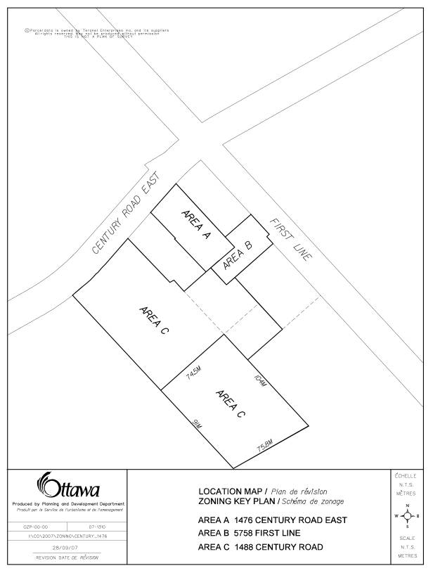
In May of this year the owners received conditional approval for lot line adjustments affecting the three subject lots (see Document 1).
Through the review of the lot line adjustments it was realized that there was a discrepancy between the zone schedule and the actual uses of the parcels. The Zoning By-law amendment proposed will correct this, in addition to recognizing other non-compliance issues, both existing and created as a result of the lot line adjustments approved by the Committee of Adjustment.
Description
of Site and Surroundings:
The
subject lands are three separate parcels of land known as 1488 and 1476 Century
Road East and 5758 First Line Road.
The
lots are in the south west quadrant of the intersection of Century Road East
and First Line Road. The subject parcels are existing undersize lots and have
been previously developed.
The
current use of the subject lands are:
1476
Century Road East - Automobile Service Station
1488 Century Road East - Various uses in accordance with M zone and Commercial storage in accordance with the M-1 zone
5758
First Line Road - Commercial use and accessory dwelling
No new development is proposed as a result of this rezoning.
DISCUSSION
The lands are designated Agricultural Resource
in the Official Plan.
The Provincial Policy Statement and the
Official Plan permit minor adjustments to lots in Agricultural Resource lands.
These lots and uses have been in existence for
a number of years and were deemed to conform to the former Township of Rideau
Official Plan. Such uses are appropriate to serve the needs of the rural
residents and the uses support the rural economy.
Based on the above this Zoning By-law amendment
does not contradict the intent of the policies of the current Official Plan.
The purpose of the Amendment is to fulfill a condition of consent for lot line adjustments granted by the Committee of Adjustment.
Where
the existing lots enjoyed legal non-complying rights, the adjusted lot
configurations results in a loss of this right. In order to legalize the lots, recognizing the new lot areas
resulting from the lot line adjustments, rezoning is necessary. The proposed
Zoning By-law will therefore recognize the adjusted lot areas and other zone
provisions not meeting the current zone provisions, as detailed and shown in
Documents 2 and 3 attached.
CONSULTATION
Notice of this application was carried out in
accordance with the City's Public Notification and Consultation Policy. The Ward Councillor is aware of this application and
the staff recommendation. The City did
not receive any negative comments or opposition to this application.
RURAL IMPLICATIONS
The rezoning supports the rural economy, permitting the adjustment of lot lines to finalize and effects the wishes of the property owners to reconfigure the lots.
FINANCIAL IMPLICATIONS
APPLICATION PROCESS
TIMELINE STATUS
This application was processed by the "On Time
Decision Date" established for the processing of Zoning By-law amendment
applications.
SUPPORTING DOCUMENTATION
Document 1 Location
Map
Document 2 Details
of Recommended Zoning
Document 3 Zoning
By-law Schedule
DISPOSITION
City Clerk’s Branch, Council and Committee
Services to notify the owners, David Houston, 2036 Cabot Street, Ottawa,
Ontario. K1H 6J8; John Hurley and John Doyle, 1476 Century Road East, R. R. #1,
Kars, Ontario. K0A 2E0, applicant, Jeffrey Shipman, Box 53, North Gower,
Ontario. K0A 2T0, OttawaScene.com, 174 Colonnade Road, Unit #33, Ottawa,
ON K2E 7J5,
Ghislain Lamarche, Program Manager, Assessment, Financial Services Branch (Mail
Code: 26 76) of City Council’s
decision.
Planning, Transit and the Environment Department
to prepare the implementing by-law, forward to Legal Services Branch and
undertake the statutory notification.
Legal Services Branch to forward the
implementing by-law to City Council.
LOCATION MAP DOCUMENT
1
DETAILS OF RECOMMENDED ZONING DOCUMENT
2
5758
First Line
1.
A new special zone (C-19) be added to subsection 10(3) including the following
special provisions:
(i)
Lot Area (minimum) 1500 square metres
(ii) Interior Side Yard Depth (minimum) for accessory structure - 2
metres
1476 Century Road
2.
A new special zone (CR-7) be added to
subsection 13(3) including the following special provisions:
(i)
Lot
Area minimum: 0.2 ha
(ii)
Lot
frontage minimum: automobile service station: 33 metres
(iii) Front Yard Depth
minimum: 11 metres
(iv) Interior Side Yard (minimum): other uses main building 6 metres - accessory shed 0 metres
(v) Rear Yard Depth
(minimum): accessory shed 7 metres
1488
Century Road (front portion)
3.
A new special zone (M-4) be added to subsection 15(3) including the following
special provisions:
(i) Lot area (minimum):
other uses: 1.0 ha
(ii) Interior Side Yard
Width (minimum): Other Uses abutting Any Other Zone for accessory shed 0.3
metres
1488
Century Road (rear portion)
4.
A new special provision be added to the M-1 special zone as follows:
(i) Lot area (minimum):
other uses: 0.7 ha
(ii) Lot frontage (minimum):
0 m
(iii) Interior
Side Yard Width (minimum): Other Uses abutting Any Other Zone: 11 metres
(iv) Rear Yard Depth
(minimum): Other Uses Abutting Any Other Zone: 14 metres
5. Schedule A, Map No. 1A be amended by:
(1) rezoning
the lands shown as Area A in Document 3 from CR to CR-7,
(2) rezoning
the lands shown as Area B in Document 3 from M to CR-7,
(3) rezoning the lands shown as Area C in Document 3 from M to C-19,
(4) rezoning the lands shown as Area D in Document 3 from R to C-19,
(5) rezoning the lands shown as Area E in Document 3 from M to M-4,
(6) rezoning
the lands shown as Area F in Document 3 from R to M-4,
(7)
rezoning
the lands shown as Area G in Document 3 from M-1 to M-4.
ZONING BY-LAW SCHEDULE DOCUMENT
3
