|
1.
ZONING - 4100 INNES ROAD
AND 2025 MER BLEUE ROAD ZONAGE - 4100, CHEMIN INNES ET 2025, CHEMIN MER BLEUE |
Committee recommendation
(This application is not subject
to Bill 51)
That Council approve an amendment to the
former City of Cumberland Urban Area By-law to change the zoning of 4100 Innes
Road and 2025 Mer Bleue Road from MS1, MS2 (Industrial Service) and MG
(Industrial General) to CC-X7(H) (Commercial Community – Exception) and
MS2-X2(H) (Industrial Service – Exception), as shown in Document 1 and as
detailed in Document 2.
Recommandation du Comité
(Cette demande n’est
pas assujettie au Règlement 51)
Que le
Conseil approuve une
modification au Règlement de zonage du secteur urbain de l’ancienne Ville de
Cumberland afin de changer la désignation de zonage du 4100, chemin Innes et du
2025, chemin Mer Bleue de MS1, MS2 (zone de service industriel) et MG (zone
industrielle générale) à CC-X7(H) (zone commerciale communautaire – exception)
et MS2-X2(H) (zone de service industriel – exception), tel qu’il est indiqué
dans le document 1 et expliqué en détail dans le document 2.
Documentation
1.
Deputy
City Manager's report Planning, Transit
and the Environment dated 19 November 2007 (ACS2007-PTE-APR-0053).
Report to/Rapport au :
Planning and Environment Committee
Comité de l'urbanisme et de l'environnement
and Council / et au Conseil
19 November 2007 / le 19 novembre 2007
Submitted by/Soumis par : Nancy Schepers, Deputy City Manager /
Directrice municipale adjointe,
Planning, Transit and the Environment /
Urbanisme, Transport en commun et Environnement
Contact Person/Personne ressource : Karen Currie,
Manager / Gestionnaire, Development Approvals / Approbation des demandes
d'aménagement
(613) 580-2424, 28310 Karen.Currie@ottawa.ca
|
SUBJECT: |
ZONING - 4100 INNES ROAD AND 2025 MER BLEUE ROAD (FILE NO.
D02-02-06-0149) |
|
|
|
|
OBJET : |
ZONAGE - 4100, chemin innes et 2025, chemin mer bleue |
REPORT RECOMMENDATION
That the Planning and
Environment Committee recommend Council approve an amendment to the former City
of Cumberland Urban Area By-law to change the zoning of 4100 Innes Road and
2025 Mer Bleue Road from MS1, MS2 (Industrial Service) and MG (Industrial
General) to CC-X7(H) (Commercial Community – Exception) and MS2-X2(H)
(Industrial Service – Exception), as shown in Document 1 and as detailed in Document 2.
RECOMMANDATION DU RAPPORT
Que le Comité de l’urbanisme et de l’environnement
recommande au Conseil d’approuver une modification au Règlement de zonage du
secteur urbain de l’ancienne Ville de Cumberland afin de changer la désignation
de zonage du 4100, chemin Innes et du 2025, chemin Mer Bleue de MS1, MS2 (zone
de service industriel) et MG (zone industrielle générale) à CC-X7(H) (zone
commerciale communautaire – exception) et MS2-X2(H) (zone de service industriel
– exception), tel qu’il est indiqué dans le document 1 et expliqué en détail
dans le document 2.
BACKGROUND
The purpose of the subject application is to request an amendment to the former City of Cumberland Urban Area Zoning By-law to change the zoning of two properties, addressed 4100 Innes Road and 2025 Mer Bleue Road, from mainly general industrial uses to commercial and service industrial uses to permit a community shopping centre, office and industrial uses.
The subject site is located in the Orleans Industrial Park and is situated on the southeast corner of the major intersection of Innes Road and Mer Bleue Road. From the intersection, the site extends approximately 400 metres east along Innes Road and approximately 450 metres south along Mer Bleue Road. The total area of the site, which comprises the two properties noted above, is approximately 25 hectares (see Document 1). An automotive garage, a single detached residence, and an outbuilding currently occupy the site’s extreme northwest corner, while a second single detached residence and accessory warehouse front onto Mer Bleue Road further south of the intersection. With the exception of these buildings, the vast majority of the site area is undeveloped. The site is generally flat and featureless, containing only a sparse cluster of mature trees and shrubs along a minor creek that flows through the northern half of the site.
The Orléans Industrial Park extends from Innes Road south to the Ontario Hydro corridor and from Tenth Line Road west to Page Road, covering an area of 316 hectares. Until recently, the industrial park had remained largely undeveloped. Over the past four years, however, a significant portion of the industrial park along Innes Road has undergone change in the form of big box retail and shopping centre development. For instance, immediately east of the subject site is “Trinity Common”, a 35 000-square metre shopping centre anchored by the Real Canadian Superstore on 26 hectares, and to the west is “Innes Shopping Centre”, a 48 000-square metre shopping centre anchored by Wal-Mart on 17.8 hectares of land. The lands south of the subject site, still within the industrial park, remain vacant. Immediately north of the subject site on the opposite side of Innes Road is the established low-density residential neighbourhood of Queenswood Heights South.
The portion of the subject site fronting along Innes Road is currently zoned “Service Industrial” (MS1 and MS2), which generally permits a range of automotive, manufacturing, industrial, commercial office, retail warehouse, and limited retail uses, including restaurants. The much larger southerly portion of the site is currently zoned “General Industrial” (MG), which restricts uses to manufacturing, industrial establishments, warehousing and some automotive trades.
The subject application proposes to change the current industrial zoning in effect over the entire site to “Commercial Community - Exception” (CC-X7) to permit a community shopping centre of up to 50 000 square metres of gross floor area, including a minimum of 1 858 square metres of office uses, and to “Industrial Service – Exception” (MS2-X2) to permit office and limited industrial uses. Document 3 illustrates the conceptual commercial development on the subject lands.
DISCUSSION
Official Plan
The Official Plan assigns two land use
designations to the subject site. As
noted above, the character of the Orléans Industrial Park abutting Innes
Road has changed significantly in recent years from one that featured
low-density industrial uses to one that is dominated by large-format
retailing. In recognition of this now
established trend, the segment
of Innes Road along which the industrial park fronts, which also includes the
subject site, was designated “Arterial Mainstreet” upon the adoption of the
current Official Plan. The Arterial
Mainstreet designation applies to the lands abutting those existing and planned
arterial roads that offer some of the most significant opportunities in the
city for intensification and that have the potential to evolve, over time, into
more compact, mixed-use, pedestrian-oriented and transit-friendly places.
Accordingly, the uses generally permitted on the abutting lands include a broad
range of retail and service commercial uses, offices, residential and
institutional uses. The policies
require that any development fronting onto an arterial mainstreet respect the
established objectives and principles of good community design set out in
Section 2.5.1, including any applicable Council-approved design guidelines, as
well as the compatibility policies of Section 4.11. The Arterial Mainstreet designation is intended to be flexible
depending on the particular site circumstances and lot configuration, but
generally extends the depth of the lots that have frontage on the designated
arterial mainstreet. In the case of the
subject site, the land use designation extends a depth of 450 metres.
The balance of the subject site south of and
behind the existing Trinity Common shopping centre is designated in the Official Plan as “Employment
Area”, which is assigned to those lands throughout the city where
concentrations of at least 2 000 jobs at a range of densities can be provided
in an effort to achieve a balance of housing and jobs, especially in
communities outside the Greenbelt. The
uses permitted in this designation include a variety of industrial and
employment-generating uses, such as warehousing, manufacturing, office,
institutional, and research and development.
Retail uses are prohibited from Employment Areas, except for convenience
commercial uses occupying small sites and intended to serve employees of the
area and the passing general public.
Other Relevant Planning Documents
Other planning documents relevant to the
proposed Zoning By-law amendment include the Orléans Industrial Land Use and
Design Study Urban Design Guidelines, December 2003, the Urban Design
Guidelines for Development along Arterial Mainstreets, May 2006, the Urban
Design Guidelines for Large-Format Retail, May 2006, and the Urban
Design Guidelines for Drive-Through Facilities, May 2006.
The Orléans Industrial Land Use and Design
Study Urban Design Guidelines were developed out of Council’s desire to
shape an overall vision for future development fronting onto Innes Road and
within the Orléans Industrial Park. Among
other initiatives, it establishes a set of urban design guidelines and
development requirements to help direct the visual image of future development
within the park.
The latter Council-approved urban design
guideline documents are intended to provide guidance at the planning
application stage in order to assess, promote and achieve appropriate
development along arterial mainstreets and of large format retail stores.
Details of Proposed Zoning
The details of the recommended changes to the Zoning By-law appear in Document 2. The Department is recommending that the “Industrial Service” (MS1 and MS2) and “Industrial General” (MG) zones that currently apply to the square portion of the property that fronts onto both Innes Road and Mer Bleue Road be changed to “Commercial Community – Exception – Holding” [CC-X7(H)] to permit the three-phased development of a 50 000-square metre community shopping centre. The proposed zoning permits the initial phase of development to achieve only a maximum of 23 225 square metres of retail floor area. The second phase of development increases the cap on floor area to a maximum of 40 000 square metres of floor area, provided it contains at least 1 858 square metres of office floor area either in the form of a freestanding building(s) or floor space above ground-floor retail uses. The final phase of development, which would bring the total floor area in the zone to a maximum of 50 000 square metres, would only be permitted once a minimum of 5 600 square metres of additional office, industrial, manufacturing and/or warehouse uses is provided on the proposed community shopping centre (office uses only) and/or on the southeast portion of the subject property that is proposed to be rezoned to Service Industrial, as described below.
The recommended exception zone and performance standards, which are unique to the subject site, are generally consistent with those of the proposed “Arterial Mainstreet” zone in the Draft Comprehensive Zoning By-law for the Urban Area and implement the relatively recent Arterial Mainstreet policies of the Official Plan to the extent possible. To ensure that the desired built form along Innes Road and Mer Bleue Road is consistent with the Arterial Mainstreet policies of the Official Plan, City staff have informed the applicant that any future site plan control development proposal for the subject site will be evaluated not only for its conformity with the recommended zone standards, but also for its high regard to the spirit of the above-noted urban design guidelines, with specific attention paid to how the proposed built form and parking areas relate to the abutting public streets.
As mentioned above, the Department is also recommending that the “Industrial General” zone that currently applies to the portion of the subject property that is directly south of and behind the existing Trinity Common Shopping Centre be changed to “Service Industrial – Exception – Holding” [MS2-X2(H)] to permit office, industrial, manufacturing and/or warehouse uses. Once again, the exception is site-specific to limit the range of uses in the zone to those that are appropriate in the context of the adjacent proposed community shopping centre.
Apart from permitting more retail commercial uses along Innes Road, the primary intent behind phasing the proposed development through the use of graduated caps on floor area is to ensure that a total of at least 7 432 square metres of office, industrial, manufacturing and/or warehouse uses are achieved throughout the entire subject property once it is fully developed.
Rationale
Staff conducted a thorough evaluation of the proposal both in terms of the site’s suitability for the requested uses and the compatibility of the requested uses with the surrounding uses and environment.
With respect to the suitability of the site for the intended uses, staff assessed the physical characteristics of the site itself as well as the availability of the existing municipal services infrastructure and road network to support the intended uses. The site is rectangular in shape, relatively featureless and presents no environmental concerns that cannot be adequately mitigated during the normal course of site development. The Master Servicing Report that was prepared in conjunction with the Orléans Industrial Park Land Use and Design Study identified that, in order to service the subject site, municipal piped services would need to be extended west from Tenth Line Road within the future alignment of Vanguard Drive. To date, the services have only been extended as far as Lanthier Drive, a distance of approximately 275 metres east of the nearest corner of the subject property, and the City has no immediate plans to further extend the road or the municipal piped services. Moreover, the section of the recently constructed sanitary sewer within Vanguard Drive is not yet in service, nor will it be until the sanitary sewer in Tenth Line Road is extended south from Vanguard Drive to the sanitary pumping station. It is for this reason that a holding provision attached to the proposed zoning is recommended. Such provision would be removed only when the necessary municipal services are extended to the subject site. Until such time, no development of the subject site would be possible.
The Transportation Impact Study and subsequent Addendum that were submitted in support of the proposed Zoning By-law amendment were also reviewed in the context of the proposed commercial development. The study concludes that the existing road network, with a few modifications, would adequately support the development of up to 23 225 square metres of commercial gross floor area. However, the surrounding existing road network would not sufficiently support any further development on the subject site. It is for this reason that a holding provision is proposed for any increase in commercial floor area over 23 225 square metres. The holding provision would be in effect until such time as the City approves a revised Transportation Impact Study that addresses increased trip generation and its effect on the surrounding road network during the year the next phase of development is proposed and five years following the build-out of development on the subject site.
With respect to the compatibility of the
requested uses with the surrounding uses, staff considered the impacts that the
proposed shopping centre would have primarily on the adjacent residential
neighbourhood of Queenswood Heights South, specifically increased noise levels,
loss of privacy, building height and mass, and lighting. Any
perceptible increase in the existing noise levels due to traffic volumes would
be largely mitigated by the 2.0-metre high sound attenuation and visual screen
fence that was recently installed along the north side of Innes Road as part of
the Innes Road upgrade and widening.
The fence is also a reasonable measure by which to safeguard the
residents’ privacy and enjoyment of their properties from any negative visual
impact of the proposed commercial development, including that of an office
building that could rise to a height of six storeys on the subject site.
However, the location of such a building, if
ever proposed, in relation to the adjacent residential neighbourhood would be
thoroughly studied during the site plan control approval process.
With respect to site lighting, including the
intensity of the light emitted by future commercial signage facing Innes Road,
residents could experience negative impacts on the enjoyment of their
properties. The City’s Sign By-law does
not regulate the light intensity of signs, so appropriate conditions will need
to be negotiated at the time of site plan control approval to reduce such
impacts.
It is staff’s opinion, therefore, that the proposed community shopping centre use conforms to the relevant policies of the Official Plan and is compatible with the surrounding uses and environment. The judicious use of holding provisions will also ensure the site’s suitability for the proposed uses.
ENVIRONMENTAL IMPLICATIONS
A
tributary of Bilberry Creek crosses the subject property flowing eastward from
Mer Bleue Road then northward to Innes Road.
Other smaller watercourses drain into the tributary, creating a rather
complex drainage system. Prior to any
development affecting this watercourse, an application for alteration of a
watercourse will be required under Section 28 of the Conservation Authority
Act, and under the federal Fisheries Act to determine whether an evaluation of
fish habitat is required. In addition,
any future stormwater management plans prepared for the subject site will have
to take the existing drainage system into account.
With
respect to the evaluation of any potential on-site environmental contamination,
because of the presence of the small service garage that is no longer in
operation on the subject site, the preparation of a Phase I Environmental Site
Assessment (ESA), and potentially a Phase II ESA, will be required.
These
requirements may be satisfied as part of a subsequent site plan control
approval application. Therefore, there
are no environmental implications sufficient to prevent the subject zoning
amendment.
RURAL IMPLICATIONS
N/A
CONSULTATION
Notice of this application was carried out in accordance with the City’s Public Notification and Consultation Policy. The Ward Councillor is aware of this application and the staff recommendation.
A number of community organizations expressed concerns with the loss of employment lands and the extent to which the lands are being rezoned from business park to commercial uses. These concerns are addressed in Document 4.
FINANCIAL IMPLICATIONS
N/A
APPLICATION PROCESS
TIMELINE STATUS
The application was not processed by the “On
Time Decision Date” established for the processing of Zoning By-law amendments
due to the time required to resolve several major issues related to the scale
of the development and servicing and transportation network availability.
SUPPORTING DOCUMENTATION
Document 1 Location
and Zoning Key Map
Document 2 Details of Recommended Zoning
Document 3 Development Concept
Plan
Document 4 Consultation Details
DISPOSITION
City Clerk’s Branch, Council and Committee
Services to notify the owner, Innes Shopping Centres Limited, 700 Applewood
Crescent, Vaughan, ON L4K 5X3, the
applicant, William S. Holzman, Holzman Consultants Inc., 1076 Castle Hill
Crescent, Ottawa, ON K2C 2A8, OttawaScene.com,
174 Colonnade Road, Unit 33, Ottawa, ON
K2E 7J5, and Ghislain
Lamarche, Program Manager, Assessment, Financial Services Branch (Mail Code:
26-76) of City Council’s decision.
Planning, Transit and the Environment
Department to prepare the implementing by-law, forward to Legal Services Branch
and undertake the statutory notification.
Corporate Services Department, Legal Services
Branch to forward the implementing by-law to City Council.
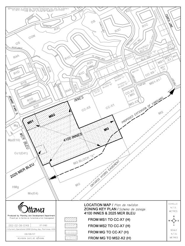
LOCATION AND ZONING
KEY MAP DOCUMENT
1
DETAILS OF RECOMMENDED ZONING DOCUMENT
2
The proposed zoning amendment affects two sections of former City of Cumberland By‑law 1 84, as amended. The proposed changes are outlined in general terms below.
1. Subsection 7.3 Commercial Community CC is amended by creating a new exception zone, CC-X7, which shall apply to the areas shown on Document 1. The new CC-X7 zone shall contain the following exceptions to the CC zone or ones having the same effect:
a. The specific zone requirements shall consist of the following:
i. a minimum Front Yard depth of 0.0 metres;
ii. a minimum External Side Yard width of 0.0 metres;
iii. a minimum Side Yard of 0.0 metres;
iv. a minimum Rear Yard of 0.0 metres; and
v. a maximum Gross Leasable Floor Area of 40,000 square metres.
b. The total Gross Leasable Floor Area (GLFA) shall not be permitted to exceed 23,225 square metres until such time as a minimum of 1,858 square metres GLFA of office use is provided in the zone.
c. The office uses required as part of a development in the zone shall either occupy a separate office building or buildings or the floor or floors immediately above the ground floor of a commercial mixed-use building.
d. The maximum total GLFA for the CC-X7 zone may be increased to 50 000 square metres when:
together are equal to or greater than 7 432 square metres.
e. The minimum required parking spaces for a shopping centre shall be 1.0 space per each 29.0 square metres GLFA.
f. A minimum of 15 per cent of a parking area shall be landscaped area, which area shall include the minimum required landscape strip abutting a public street, and interior landscaping in the form of landscaped islands, landscaped medians, pedestrian pathways or public plazas.
g. The minimum width of a driveway, lane or aisle shall be 6.5 metres.
h. The storage of garbage outside a main building shall be permitted in any yard except a front or an external side yard, and such storage shall be visually screened in accordance with the current provisions of the By-law.
i. A garden centre or similar seasonal facility shall not be permitted in a yard abutting a public street.
j. A driveway that provides ingress and egress to and from any lot or parking space within the CC-X7 zone may pass through other zones.
k. Despite anything to the contrary in By-law 1-84, the lands zoned CC-X7 shall be considered one lot for zoning purposes, notwithstanding the lawful division of a lot pursuant to the Planning Act, as amended, the Condominium Act, as amended, or any other similar legislation.
l. The following applies to any lands zoned CC-X7 and subject to a holding symbol (H) shown on the Schedules:
The following conditions must be satisfied prior to the removal of the holding provision:
i. A connection to the sanitary sewer within the Vanguard Drive public road allowance must be provided;
ii. The
sanitary sewers within Vanguard Drive and Tenth Line Road south of Vanguard
Drive must be constructed to the Tenth Line Road sanitary pumping station and
be put into service; and
iii. When the first two conditions of
holding are satisfied, development in the CC‑X7 zone or adjacent MS2-X2
zone may proceed provided the combined total gross floor area in both zones
does not exceed 23,225 square metres.
However, prior to any further development in excess of the combined
total gross floor area of 23,225 square metres in either zone, the following
condition of holding must be satisfied, at which point in time the holding (H)
symbol identified on Schedule E may be removed:
1. The City must approve a Transportation Impact
Study, the recommendations of which are to be implemented as a condition of
development. Such study must address
the increased trip generation and its effect on the surrounding road network
during the year that any additional development in either zone is proposed and
five years following the build-out of development in both zones.
All other zone requirements of the CC zone shall continue to apply.
2.
Subsection 8.6 Industrial Service MS2 is amended by
creating a new exception zone, MS2-X2, which shall apply to the area shown on
Document 1. The new MS2-X2 zone shall
contain the following provisions or ones having the same effect:
- The following MS2 uses are prohibited
in the MS2-X2 zone:
(i) Bowling Alley Establishment
(ii) Garden Centre
(iii) Golf Establishment (Indoor)
(iv) Restaurant
(v) Retail Warehouse;
And the following additional use shall be permitted in the MS2-X2 zone:
(i) Light assembly and manufacturing industry.
(ii) School, Commercial
- A driveway that provides ingress and
egress to and from any lot or parking space within the MS2-X2 zone may pass through other zones.
- The following applies to any lands zoned MS2-X2 and subject to a holding symbol (H) shown on the Schedules:
The following conditions must be satisfied prior to the removal of the holding provision:
i. A connection to the sanitary sewer within the Vanguard Drive public road allowance must be provided;
ii. The sanitary sewers within Vanguard Drive and Tenth Line Road south of Vanguard Drive must be constructed to the Tenth Line Road sanitary pumping station and be put into service; and
iii. When the first two conditions of
holding are satisfied, development in the MS2‑X2 zone or adjacent CC-X7
zone may proceed provided the combined total gross floor area in both zones
does not exceed 23,225 square metres.
However, prior to any further development in excess of the combined
total gross floor area of 23,225 square metres in either zone, the following
condition of holding must be satisfied, at which point in time the holding (H)
symbol identified on Schedule E may be removed:
1. The City must approve a Transportation Impact
Study, the recommendations of which are to be implemented as a condition of
development. Such study must address
the increased trip generation and its effect on the surrounding road network
during the year that any additional development in either zone is proposed and
five years following the build-out of development in both zones.
All other zone requirements of the MS2 zone shall continue to apply.
DEVELOPMENT CONCEPT PLAN DOCUMENT
3

CONSULTATION DETAILS DOCUMENT
4
NOTIFICATION AND CONSULTATION PROCESS
Notification and public consultation was undertaken in
accordance with the Public Notification and Public Consultation Policy approved
by City Council for Zoning By-law amendments.
No public information sessions were held in the community.
PUBLIC COMMENTS
No comments concerning the proposed Zoning By-law amendment were received from individuals.
COUNCILLOR’S COMMENTS
During a meeting held with City staff immediately following the submission of the initial application, Councillor Jellett expressed similar concerns with the proposed zoning to those of the three community organizations outlined below. Councillor Jellett is concerned with the further loss of employment lands in Orléans to retail development. He expressed that the proposed development should provide non-retail employment opportunities.
Response
As noted below, the proposed amendment to the Zoning By-law contains a requirement to provide a minimum of 7 432 square metres of industrial and office floor space throughout the subject retail and industrial development.
COMMUNITY ORGANIZATION COMMENTS
Comments were received from three community organizations, including the Orléans Chamber of Commerce, Team Ottawa-Orléans, and the Innes Re-zoning and Development Group. The comments provided were similar in nature, as summarized below.
The primary issue expressed by all three organizations focused on the continued erosion of employment lands in Orléans in favour of retail development. While the organizations recognize that the proponent’s development plan provides for future office space in the southeast corner of the site, they would prefer to see a greater commitment toward providing office uses in the retail component of the development, which is consistent with the Arterial Mainstreet policy initiatives. There is an opportunity with this development, situated at a major gateway entrance to the Orléans Industrial Park, to complement the future industrial and office character of the area.
By including a significant office component, several objectives would be met: an immediate customer base would be provided for the retailers on the site; it would answer a need for office space in Orléans; and it would contribute toward providing a stronger career-oriented employment base in Orléans.
All three organizations also expressed concern that the proposed depth of the retail development into the business park would establish a precedent for more retail development in the future rather than industrial development that is so desperately needed to balance the growth of Orléans and the city as a whole.
However, the three organizations expressed support, although qualified, for the proposed development. Their support is provided only if a sizeable office component is a requirement of the zoning amendment for the subject site. Such office use could include either a stand-alone office building or office space located on the second and upper floors above ground-floor retail space.
Response
The Department shares the concerns expressed by the three community organizations. Therefore, following discussions between the proponent and city staff, a mutually acceptable solution was reached. The proposed amendment to the Zoning By-law contains a requirement to provide a minimum of 1 858 square metres of office use floor space as part of the shopping centre development. Another 5 574 square metres of industrial and office floor space are to be provided on the shopping centre site and/or the adjacent lands to be rezoned to Industrial Service-Exception. The form and location of this required office and industrial floor space will be determined during the site plan control approval process with the full consultation and input of the above community organizations and the general public.
ADVISORY COMMITTEE COMMENTS
The Ottawa Forests and Greenspace Advisory
Committee (OFGAC) does not object to the proposed Zoning By-law amendment, but
nonetheless provided recommendations to City staff for consideration during the
review and evaluation of any future application for site plan control approval
on the subject site. OFGAC recommended
that several spruce trees on the site are suitable to be transplanted and
incorporated into the proposed landscaping scheme.
Response
The recommendations of the Committee are so noted.