|
4. ZONING - PARTS OF 333 BRADWELL WAY AND 500 WHITE ALDER DRIVE ZONAGE -
PARTIES DU 333, VOIE BRADWELL ET DU 500, PROMENADE WHITE ALDER |
Committee recommendation
(This application is subject
to Bill 51)
That Council approve an amendment to the former City of
Gloucester Zoning By-law to change the zoning of parts of 333 Bradwell Way and
500 White Alder Drive as shown in Document 1 and as detailed in Documents 2 and
3.
Recommandation du Comité
(Cette demande est
assujettie au Règlement 51)
Que le Conseil approuve une modification
au règlement de zonage de l’ancienne Ville de Gloucester visant à changer le
zonage de certaines parties du 333, voie Bradwell et du 500, promenade White
Alder, comme il est indiqué dans le document 1 et expliqué dans les documents 2
et 3.
Documentation
1.
Deputy
City Manager's report Planning, Transit
and the Environment dated 5 October 2007 (ACS2007-PTE-APR-0186).
Report to/Rapport au :
Planning and Environment Committee
Comité de l'urbanisme et de l'environnement
and Council / et au Conseil
05 October 2007 / le 05 octobre 2007
Submitted by/Soumis par : Nancy Schepers, Deputy City Manager
Directrice municipale adjointe,
Planning, Transit and the Environment
Urbanisme, Transport en commun et Environnement
Contact Person/Personne ressource : Karen Currie,
Manager / Gestionnaire, Development Approvals / Approbation des demandes
d'aménagement
(613) 580-2424, 28310 Karen.Currie@ottawa.ca
|
SUBJECT: |
ZONING - Parts of 333 Bradwell Way and
500 White Alder Drive (FILE NO. D02-02-07-0074) |
|
|
|
|
OBJET : |
ZONAGE –
parties du 333, voie bradwell et du 500, promenade white alder |
REPORT RECOMMENDATION
That the recommend Council approve an
amendment to the former City of Gloucester Zoning By-law to change the zoning
of parts of 333 Bradwell Way and 500 White Alder Drive as shown in Document 1
and as detailed in Documents 2 and 3.
RECOMMANDATION DU RAPPORT
Que le Comité de Que le Comité de recommande au Conseil d’approuver une modification au règlement de
zonage de l’ancienne Ville de Gloucester visant à changer le zonage de
certaines parties du 333, voie Bradwell et du 500, promenade White Alder,
comme il est indiqué dans le document 1 et expliqué dans les documents 2 et
3.
BACKGROUND
The lands that are the subject of this zoning application are located within Leitrim – Stage 2 Draft Approval Area, approved July 7, 2006. Leitrim Stage 2- Phase 1 (Phase 2-1) is located west of Kelly Farm Drive and north of the future extension of Findlay Creek Drive.
Leitrim Stage 2 – Phase 2a (Phase 2-2a) is located north of the present build up Leitrim community know a Findlay Creek Village (Stage 1) at the end of Kelly Farm Drive. The majority of the land to be developed is located east of the Kelly Farm Drive extension.
Purpose of
Zoning Amendment
The applicant wishes to make several modifications to the approved zoning for Leitrim – Stage 2 to reflect the changes that have been made to the size and location of parkland within the Phase 2-1 and Phase 2-2a lands and to recognize an open space block in the Phase 2-2a lands. The changes are necessary due to the finalization of parkland dedication requirements, the receipt of completed survey fieldwork and proposed unit counts together with a more detailed subdivision design supported by a full range of engineering studies for these two phases.
The lands that are the subject of this Zoning By-law amendment are presently zoned Special Mixed Residential Dwellings (Exception 62), Rc3(E62) and Open Space, OS.
The applicant is requesting that the zoning of the various parcels of lands be changed to reflect a shifting in the zoning boundaries between residential lands and parkland. The changes requested will involve rezoning lands from Rc3(E62) to OS or from OS to Rc3(E62). Also the applicant is requesting that the future use of a block as part of a stormwater management facility be recognized by changing the zoning from Rc3(E62) to OS. These changes are shown in detail on Document 3.
DISCUSSION
The Official Plan places the lands that are the subject of this Zoning By-law amendment in the General Urban Area with a Developing Community overlay within the Airport Vicinity Development Zone. The General Urban Area designation facilitates the development of complete and sustainable communities. The Airport Vicinity Development Zone ensures that all development is to be protected from the effects of aircraft noise. The Leitrim Community Design Plan was approved in July 2005. A Draft Subdivision Approval for Leitrim – Stage 2 was issued July 7, 2006. A Zoning By-law for a majority of the Stage 2 lands was approved September 27, 2006.
The original zoning which the applicant now wishes to amend was based on the layout of the subdivision that was draft approved. Since that time, survey fieldwork has been completed, the parkland dedication requirements for the entire Stage 2 draft approval area have been updated and a more detailed phased subdivision layout together with engineering design has been submitted.
The application was received in July 2007 with an amendment request received in August 2007. In response to the community’s concern about a proposed reduction in the park size in Phase 2‑2a, the application was further amended in October 2007.
The amendment to the application was to further modify the zoning along the westerly Central Park boundary, increase the size and change the location of the North Park and add a block of land to the west of the Kelly Farm Drive extension to be rezoned. The ‘OS’ zone permits park uses together with stormwater management facilities.
Due to the aforementioned ‘fine tuning’ of the draft approved subdivision plan as part of phased registration process, several shifts in the zone boundaries between residential and open space lands are necessary for Phase 2-1 and Phase 2-2a. Also, upon receiving detailed survey information and accurate unit counts, the parkland dedication requirements were confirmed and this has resulted in the change of park areas in both phases. A small strip of land in Phase 2-2a west of Kelly Farm Drive is to be rezoned from residential to open space, as these lands are to become part of the future stormwater management facility that will service Leitrim. Document 3 has been provided for information purposes to illustrate the zoning changes.
The two parks that are impacted by this zoning amendment are as follows. In Phase 2-1, the Central Park was draft approved and zoned with an area of ± 5.99 hectares. The Central Park is now to be 5.038 hectares. It should be noted that part of the change in this park size is due to the increase in width of the drainage ditch from 10 metres (draft approval) to 25 metres (Draft 4M-plan) because of design requirements. The North Park in Phase 2-2a was ±0.62 hectares (draft approval) and is now 0.61 hectares (Draft 4M-plan). Initially, this Zoning By-law amendment application had requested a reduced North Park, having an area of 0.42 hectares to be rezoned. The residents and Councillor were concerned about the ability of this smaller park size to adequately service the new northern neighbourhood. In response to these concerns, the developer has relocated the park and increase its size to 0.61 hectares.
The change in size of the neighbourhood park within the Stage 2 – Phase 2a lands is considered to be a ‘fine tuning’ of dimensions and areas that will happen between the Draft Approved step and 4M-plan step when final survey fieldwork has been completed and the development design is finalized.
Staff has received several
inquiries from residents within the existing Leitrim Community about the above
noted change in the North Park size. The
Leitrim Community Design Plan, approved by Council in July 2005, states that
neighbourhood parks can range in size from 0.4 to 0.8 hectares. These
parks are envisioned as neighbourhood gathering places and would be the site
for informal play, children's play facilities, community mailboxes and
community bulletin boards. There is to be a community park abutting Phase
2a along its western border.
This large Community Park is to
accommodate sports fields and other active recreation facilities. As well, a stormwater management facility
will abut this park.
The City has undertaken a full review of the Leitrim - Stage 2 Draft Subdivision Approval area and the Planning Act requirements for parkland dedication. In accordance with the revised Stage 2 Draft Plan of Subdivision dated August 28/07 and unit count numbers (both proposed and estimated); the City is obtaining the required parkland through the Planning Act for Leitrim Stage 2. This parkland will meet the targets to build a community with a well-distributed greenspace network as set out in the City’s Official Plan, the Greenspace Master Plan – Strategies for Ottawa’s Urban Greenspaces and the Leitrim Community Design Plan.
The zoning changes requested by the applicant are in conformity with the City’s Official Plan and meets the intent of the Leitrim Community Design Plan to provide parks in developing communities based on the municipality’s ability to receive parkland through the Planning Act and the overall community’s need.
ENVIRONMENTAL IMPLICATIONS
There are no environmental implications that
will result from the shifting of the zoning boundaries between residential and
open space as contemplated.
CONSULTATION
Notice of this application was carried out in
accordance with the City's Public Notification and Consultation Policy. The Ward Councillor is aware of this application and
the staff recommendation.
There have been several telephone inquires made
by residents and five e-mails received from residents presently living in
Leitrim – Stage 1. The residents’
concerns centered on the reduction in the size of the park in the north portion
of Leitrim – Stage 2 development lands to 0.42 hectares. All were opposed to the size reduction of
the neighbourhood park located to the north of existing Leitrim Community. With the subsequent increase in the park
size 0.61 hectares, this issue has been resolved. No comments were received on the other areas
being rezoned that are also part of this application.
Comments were received on the quality of the air emission for the Hope Cemetery crematorium to the north of the Phase 2-2a lands. Since this is an environmental matter that is under the mandate of the Ontario Ministry of Environment (MOE), contact details for the MOE were provided to the residents on this matter
FINANCIAL IMPLICATIONS
APPLICATION PROCESS
TIMELINE STATUS
This application was not processed by the "On
Time Decision Date" established for the processing of Zoning By-law
amendment applications due to the park size issue.
SUPPORTING DOCUMENTATION
Document 1 Location
Map
Document 2 Details
of Recommended Zoning
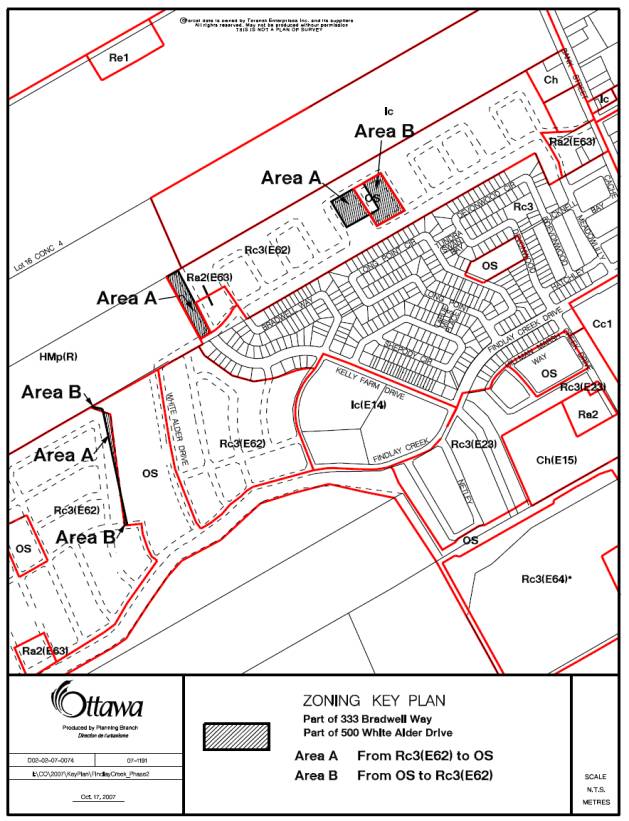
Document 3 Zoning
Key Map
DISPOSITION
City Clerk’s Branch, Council and Committee
Services to notify the owner and applicant, Melissa Dionne, Land Use Planner,
Tartan Land Corporation, 237 Somerset Street West, Ottawa, Ontario, K2P 0J3, OttawaScene.com, 174 Colonnade Road, Unit #33, Ottawa,
ON K2E 7J5,
Ghislain Lamarche, Program Manager, Assessment, Financial Services Branch (Mail
Code: 26‑76) of City Council’s
decision.
Planning, Transit and the Environment
Department to prepare the implementing by-law, forward to Legal Services Branch
and undertake the statutory notification.
Legal Services Branch to forward the
implementing by-law to City Council.
LOCATION MAP DOCUMENT
1

DETAILS OF RECOMMENDED ZONING DOCUMENT
2
The following changes are proposed to Zoning By-law 333 of 1999 of the former City of Gloucester:
1. The parcels of land that are part of 500 Bradwell Way and 500 White Alder Drive on Document 1 are to be rezoned as follows and that Map 23D of Zoning By-law 333 of 1999 be amended to reflect the following zones as shown in Document 3:
Area A Rc3(E62), Special Mixed Residential Dwelling (Exception 62) be rezoned to
OS, Open Space
Area B OS be rezoned to Rc3(E62)
ZONING KEY MAP DOCUMENT
3