|
8. ZONING
- 420 MAYFAIR AVENUE, 401 AND 415 PICCADILLY AVENUE ZONAGE - 420,
AVENUE MAYFAIR, 401 ET 415, AVENUE PICCADILLY |
Committee recommendationS AS
AMENDED
(This application is subject
to Bill 51)
1. That
Council approve an amendment to the former City of Ottawa Zoning By-law to
change the zoning of 420 Mayfair Avenue and 401 and 415 Piccadilly Avenues from
I1 and R3G to an I1 exception zone and two R3A exception zones as shown in
Document 1 and as detailed in Document 2.
2. That the Zoning By-law Amendment be repealed should the
owner not obtain Site Plan Control approval in accordance with the concept plan
included as Document 5 within 9 months from the date of enactment of the
implementing zoning by-law amendment.
RecommandationS modifiÉes du Comité
(Cette demande est
assujettie au Règlement 51)
1. Que le Conseil approuve une modification au Règlement de zonage de l’ancienne Ville d’Ottawa visant à modifier le zonage des propriétés situées au 420, avenue Mayfair et aux 401 et 415, avenue Piccadilly, et de le remplacer par une zone d’exception à la désignation I1 et deux zones d’exception à la désIgnation R3A, comme l’illustre le document 1 et le précise le document 2.
2. Que la modification au Règlement de
zonage soit abrogée si le plan d’approbation n’est pas approuvé conformément au
plan conceptuel inclus en tant que Document 5 dans les neuf mois suivant la
date d’adoption de la mise en œuvre du règlement de zonage.
Documentation
1.
Deputy
City Manager's report Planning, Transit
and the Environment dated 6 November 2007 (ACS2007-PTE-APR-0201).
2.
Extract
of Draft Minutes, 27 November 2007.
Report to/Rapport au :
Planning and Environment Committee
Comité de l'urbanisme et de l'environnement
and Council / et au Conseil
06 November 2007 / le 06 novembre 2007
Submitted by/Soumis par : Nancy Schepers, Deputy City Manager
Directrice municipale adjointe,
Planning, Transit and the Environment
Urbanisme, Transport en commun et Environnement
Contact
Person/Personne Ressource : Grant Lindsay, Manager / Gestionnaire,
Development Approvals / Approbation des demandes d'aménagement
(613)
580-2424, 13242 Grant.Lindsay@ottawa.ca
|
SUBJECT: |
ZONING - 420 Mayfair Avenue, 401 and
415 Piccadilly Avenue (FILE NO. D02-02-07-0083) |
|
|
|
|
OBJET : |
REPORT RECOMMENDATION
1.
That the recommend Council approve an amendment to the former City of
Ottawa Zoning By-law to change the zoning of 420 Mayfair Avenue and 401
and 415 Piccadilly Avenues from I1 and
R3G to an I1 exception zone and two R3A exception zones as
shown in Document 1 and as detailed in Document 2.
2.
That the implementing by-law not proceed to City
Council until a site plan is approved pursuant to Section 41 of the Planning Act.
RECOMMANDATION DU RAPPORT
1.
Que le Comité de recommande au Conseil d’approuver une modification au Règlement de
zonage de l’ancienne Ville d’Ottawa visant à modifier le zonage des propriétés
situées au 420, avenue Mayfair et aux 401 et 415, avenue Piccadilly, et de
le remplacer par une zone d’exception à la désignation I1 et deux zones
d’exception à la désIgnation R3A, comme l’illustre le document 1 et le précise
le document 2.
2.
Que
le règlement de mise en œuvre ne soit pas soumis au Conseil municipal tant
qu’un plan d’implantation n’aura pas été approuvé aux termes de l’article 41 de
la Loi sur l’aménagement du territoire.
BACKGROUND
The
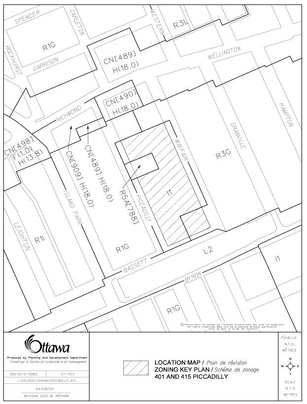
subject properties, located at 420 Mayfair Avenue and 401 and 415 Piccadilly
Avenue, are located south of Wellington Street West between Piccadilly Avenue
and Mayfair Avenue, as shown on the attached location map (Document 1).
St.
George's Elementary School located at 401 Piccadilly was built in 1939. The school building and grounds are no
longer in use, and the building is slated for demolition. The southern portion of the property has
been used by the School for parking and outdoor recreation. For decades, this area has also been used
for Sunday parking by the congregation of St. George’s Church.
St.
George's Church, located at 415 Piccadilly Avenue, was built in 1924. The Church is on the Heritage Reference
List. The Church's gross floor area is
1 020 square metres and has a height of 13.0 metres. The ecclesiatical residence was built in the 1950s and has a GFA
of 200 square metres and a height of 9.0 metres. A link between the Church and residence was built in the late
1960s. The south end of the property is
used by the Church for outdoor recreation and has two tennis courts.
The
surrounding area, located south of Richmond Road, is residential and consists
predominantly of single detached dwellings and several semi-detached
dwellings. Also contained within the
immediate community are duplex dwellings, a multiple apartment building and an
affordable housing residence for women.
Existing
Zoning
Site
- The existing zoning of the School and Church lands is I1, a Minor
Institutional Zone. This zone permits a
range of neighbouring-serving, emergency and institutional uses. The zone designation contains minimum lot
width and lot area requirements and minimum yard and height restrictions. The institutional zone requires a minimum
width of landscaped area abutting a residential zone.
A
portion of the Church lands at the corner of Mayfair Avenue and Bassett Lane is
zoned R3G. The R3 zone is a residential
Converted House/Townhouse Zone that permits a range of low density dwelling
types on individual lots or in a planned unit development (PUD). The G subzone prohibits such uses as a
converted house, planned unit development, townhouse and triplex house limited
to a converted three-unit house.
Surrounding
community - The lands to the west of the site along Piccadilly Avenue are zoned
R1G, a detached house subzone with minimum lot width and lot area
requirements. The lands east of the
site along Mayfair Avenue are zoned R3G which is the identical zoning to the
portion of the Church lands, as described above.
The
minimum front yard setback for development in the adjacent R1G or R3G subzones
is 3.0 metres. The minimum side yard
setback ranges from 0.3 metres to 1.2 metres.
The
subject site surrounds an R5A[788] zoned parcel of land that was rezoned in
2000 to permit "Daybreak" an affordable housing residence for
women.
Proposed
Zoning
Proposed
Zoning amendment for Area A
Area
A includes single detached, semi-detached and townhouse dwellings. The proposed dwellings are freehold units
within a planned unit development. A
common elements agreement will be established to provide a framework for the
shared use, ownership and maintenance of driveways etc.. In order to allow for the proposed
development, it is requested that the property be rezoned from I1 to a new R3A
exception zone. The exception addresses the frontage requirements of a house on
a private way within a PUD, as well as modifies two PUD regulations. The latter establish a minimum required
interior side yard adjacent to an institutional use and a minimum setback from
a private way, as detailed in Document 2.
Proposed
Zoning amendment for Areas B and C
Consent
(severance) applications were granted by the Committee of Adjustment on
September 19, 2007, to exchange the lands of the School property, that the
Church has used for parking, for the lands to the south of the Church fronting
Bassett Lane. The consent applications
create deficiencies as they pertain to the Church's interior side yard and the
requirement for institutional landscaped area abutting a residential zone. The acquisition of the parking lot further requires
the establishment of a parking rate for the Church and a reduction in the
minimum parking space length, as detailed in Document 2.
A
portion of St. George’s Church site after the land exchange is zoned R3G. It is proposed that this area be changed to
an institutional zoning to reflect the current use.
Proposed
Zoning amendment for Areas D and E
The
applicant proposes to build semi-detached and townhouses in this area. The proposed dwellings are freehold units
within a planned unit development. A
common elements agreement will be established to provide a framework for the
shared use, ownership and maintenance of driveways etc.. In order to allow for the proposal, it is
requested that the property be rezoned from I1 and R3G to a new R3A exception
zone. The exception addresses the
frontage requirements of a house on a private way within a PUD, as well as
modifies two PUD regulations. The
latter establish a minimum required interior side yard adjacent to the Church
site and a minimum corner side yard abutting Bassett Lane, as detailed in
Document 2.
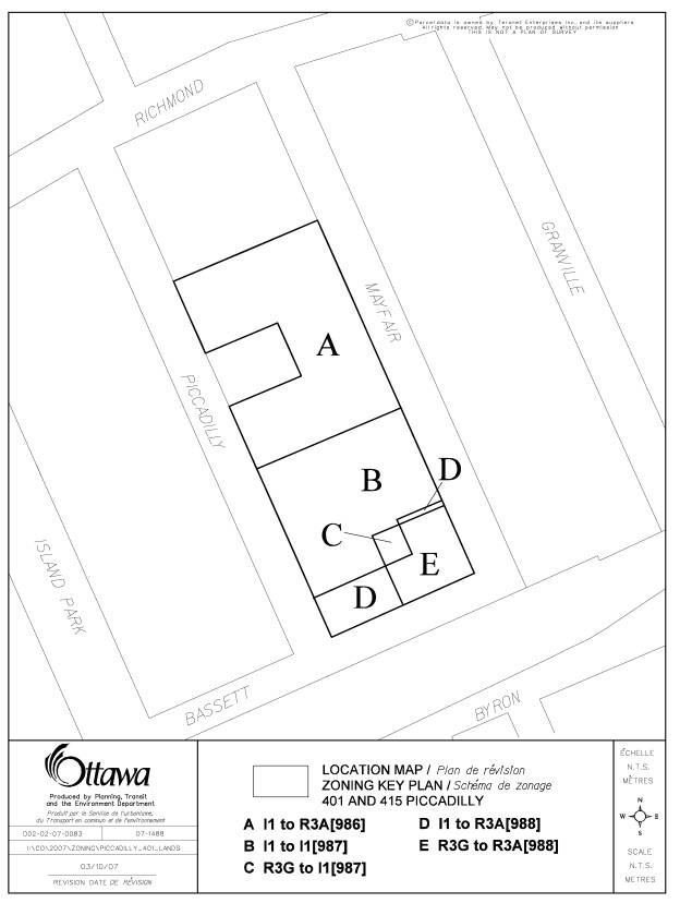
Document
3 illustrates all of the proposed Areas A through E, as described above.
Recommendation
2 to this report requires that the implementing by-law not proceed to City
Council until a site plan has been approved.
Related Planning Applications:
D08-01-07/B-00291 - Severance Application granted
to convey a portion of the St. George’s Elementary School property to St.
George’s Church to permit parking.
D08-01-07/B-00292
- Severance Application granted to subdivide the Church property into two
separate parcels of land to permit residential units along Bassett Lane.
Site Plan Application for 35 freehold units has yet to be filed with this Department.
An Application
for Lifting Part Lot Control to permit the creation of the 35 new residential
lots and private ways has not yet been filed with this Department.
DISCUSSION
The Official Plan has designated the
subject lands as General Urban Area. Lands
with this designation are intended to permit the development of a full range
and choice of housing types to meet the needs of all ages, incomes and life
circumstances. Conveniently located
employment, retail, service, cultural, leisure, entertainment and insitutional
uses are also anticipated with the vision of creating and facilitating complete
and sustainable communities.
While the Official Plan supports a
broad mix of uses within this General Urban Area designation, this does not
imply that all uses are appropriate at any location. The Zoning By-law establishes the types of land uses permitted on
a site and through site-specific zoning amendments the City can ensure that
zoning proposals remain appropriate and compatible with the surrounding uses. The City supports infill development and
other intensification in a manner that enhances and complements the overall
community character to ensure its long-term vitality. When considering a proposal for residential intensification, the
City must recognize the importance of the existing neighbourhood so that new
developments enhance and build upon desired established community patterns and
built forms.
The Official Plan also indicates
that consideration be given to achieving a balance of housing types and tenures
in order to provide a full range of housing for a variety of demographic
profiles. It is the Department's
position that this proposal supports those policies in the Official Plan that
speak to intensification at the appropriate location, is compatible with the
adjacent community character and, in the long term, will promote the area's
vitality. Furthermore, this proposal
utilizes a vacated and undeveloped parcel of land that will provide housing
types for a variety of demographic profiles.
Notwithstanding the policies
described under General Urban Area, there are additional policies in Section
2.5.1 and Section 4.11 that address the meaning of compatibile development and
set out objective criteria to evaluate the appropiateness and suitability of
developments within the existing planning context. Compatible development in the Plan means a development that
enhances an established community and coexists with the existing development
without causing undue adverse impacts on the surrounding properties. Compatible development does not necessarily
mean the same as or similar to existing buildings in the area.
The Official Plan states that a
proposal can be designed to fit within a certain existing context and work well
among those functions that surround it and not be the same as the existing
neighbourhood. Section 4.11 contains
the objective criteria that evaluates compatibility and incorporates the more
traditional planning and urban design considerations of built form, such as
height, mass, scale relationship, building/lot relationships,
sunlight/shadowing and the operational characteristics, such as traffic, access
and parking.
The proposed development allows for
a pattern of intensification that is compatible with the scale of the neighbourhood
and in keeping with the established zoning of the area. The layout pattern and built form of the new
units reinforce the current housing pattern by means of accommodating
street-oriented detached and semi-detached dwellings facing existing homes of the
same or compatible housing types across the street. In the case of Bassett Lane, the new dwelling units face no
residential homes, but instead a leisure open space corridor. There is one block of townhouses proposed
along each of the project's three street frontages. This housing type is not found on the adjacent streets, but is
located in other R3 zones in the surrounding area. This housing type works well within the present urban context and
will respect the overall community character.
The townhouse use provides a
diversity in housing and causes no undue adverse planning or urban design
impacts on the existing properties. Two
additional townhouse blocks are situated internal to the project that are not visible
from Mayfair and/or Piccadilly Avenues and, therefore, not expected to disrupt
the functions that surround them. Given
the size of the subject property, the applicant's request to permit a planned
unit development, as a permitted use, is desirable, as it facilitates the
redevelopment of the lands in an orderly fashion, as well as provides the
opportunity to obtain overall approval of the project through the site plan
control process.
The development has a 10.7-metre
building height limit. This represents
a low form of development that is identical to residential heights permitted
elsewhere in the community.
Consequently, shadowing is not expected to be an issue. Given that this is a low to medium density
development, the operational characteristics (traffic, access, etc.,) are not
expected to make a significant impact on the current levels of service at
nearby intersections and represent a decrease in on-street traffic from the
time when the former school was operational.
The traffic generated from this project is expected to be 21 trips in
the a.m. peak hour (one vehicle every three minutes in the peak hour) and 26
trips in the p.m. peak hour, while the former 3,000 square metre elementary
school generated 151 trips in the a.m. and 101 trips in the p.m. peak hours. It is not anticipated that the project will
create a significant noise impact to the surrounding area, as this is a
residential proposal that is designed to fit well within its surroundings.
The urban design approach for this
development is sensitive to the overall community character and introduces a
number of site plan and design initiatives that positively contribute to
achieving compatibility of proximate uses and built form. These design initiatives include:
·
eliminating
individual driveways and de-emphasizing garage doors along the street frontages
for 74 per cent of the new units. The
sharing of driveways to minimize driveway entries and the placement of the
garages at the rear of units improve the quality of the streetscape experience
for pedestrians and allow the focus to be more appropriately directed toward
front entrances and front porches.
·
siting
of the townhouses to minimize their impact on existing properties. This is achieved by locating them internal
to the project, adjacent to the Church parking lot, or opposite the Byron
Avenue corridor.
·
changing
the architectural styles and building heights within the project. The elevations submitted show building
styles and built forms that pick up on the existing vernacular, as well as
introduce more contemporary elements.
The different architectural treatments planned for these lands promote
flexibility and variation that is key to successful intensification.
·
attempts
to retain a large amount of the existing vegetation along the pheriphery of the
site. The applicant is very aware of
the imporance of maintaining the on-site and boulevard vegetation, as it
represents the existing community character.
·
staggering
the building setbacks along the street frontage. All units (with the exception of the units facing Bassett Lane)
meet or exceed the minimum 3.0-metre yard setback from a street. The setbacks in Area A range from 3.0 metres
to 9.9 metres. The staggering of the
units adds interest and variety to an existing neighbourhood of uniform
building setbacks. The new units will
further fill out and complete the streetscape.
The proposed zoning includes
exceptions to the Zoning By-law as they affect the Church site and the two new
residentially zoned parcels of land.
Church Lands (Areas B and C) - The
zoning exceptions for the Church site come about as a result of the land
exchange with the applicant. The Church
gains a permanent parking lot on the north side of their property in exchange
for redeveloping the lands fronting Bassett Lane. The establishment of the new severence line separating the
Bassett Lane homes from the Church site creates the need to vary the Church's
interior side yards and to seek relief from the provision for a landscaped area
abutting a residential zone. The
proposed setback of the existing Church and eccliastical residence from the new
property line and the requirement to provide no landscaped area adjacent to a
ecclesiastical residence and its driveway are acceptable and create no undue
hardship for the Church, the new residents of Bassett Lane, or existing
residents. New fencing is proposed
along the new institutional boundaries abutting the new residential zones and
will provide sufficient screening of the institutional land. The amendment also establishes a new parking
rate for the Church. This amount
reflects the current number of available parking spaces on the former school
yard beside the Church. It is also
necessary to reduce the length of a parking space to 4.8 metres, as these spaces
presently do not conform to the By-law.
The small portion of the Church site
that is being rezoned from R3G (Area C) to institutional ensures that all
Church lands contain a uniform zoning.
Residential Lands - The two, new
residentially zoned parcels of land contain an R3A subzone with seperate
exceptions that are designed to accommodate the proposed planned unit
developments. The R3A subzone was
selected, as a planned unit development is a permitted use in this
designation.
Area A - The project conforms to
most regulations of the planned unit development use under the current Zoning
By-law. The amendment modifies the
frontage requirements of a house on a private way, the interior side yard
adjacent to an institutional use and the setback from a private way.
The proposed amendment is
appropriate and generally seen as minor in nature. The reduction in the width of the private entrance way applies to
the internal driveways leading to the units and, in most cases, the driveway
adjacent to the garages widens to the required private way width of
6.0 metres. The exception occurs
along the driveways fronting the two internal townhouse blocks. In these areas the setback from the edge of
the private way to the garage was increased to faciliate access to the
units. It is not anticipated that the
proposed private way will interfere with internal vehicular circulation or
result in any traffic conflicts with vehicles entering and exiting the site. The proposed relief from the building
setback provision from a private way generally affects those situations where
the private way is located near the face of a building without a garage. The reduced setback can still accommodate a
landscaped area beside a building wall.
The proposed internal side yard modification abutting the institutional
use creates no undue hardship for the Church or the new residents living beside
the Church and is acceptable.
Areas D and E - The dwelling units
in this zone are sited to allow all vehicular access from a shared driveway or
private way running along the rear of the buildings. This eliminates the need for individual driveways and garages on
the block fronting Bassett Lane. The placement
of the private way behind the units and the need to satisfy the building
setback requirement from a private way result in the buildings in this PUD
locating closer to the Bassett Lane property line. The proposed minimum 2.0-metre setback along Basset Lane is
acceptable, as it has nominal impact on nearby properties, the units face an
open space corridor, and the building orientation and emphasis is shifted from
garages to entrances and porches. For
all other cases, the buildings meet or exceed the required 3.0-metre setback
from a street.
The PUD provides for a wider yard
setback along the Piccadilly frontage that maintains views of the rectory and
Church from the Piccadilly and Bassett intersection and protects existing
vegetation.
Recommendation 2
The Department believes that the
proposed building layout, the sharing of driveways, the retention of the
existing vegetation, the unique architecture etc., are all essential site plan and design elements that make this
development fit well within its physical context and work well among those
functions that surround it. The zoning
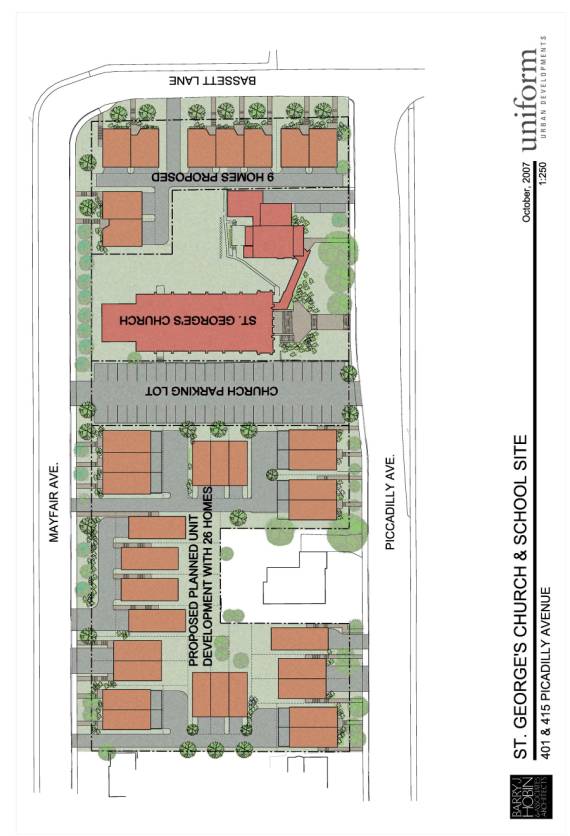
is tailored to suit the proposed conceptual site plan (see Document 5) and,
therefore, the Department wants to ensure that this is the plan that the
Department eventually approves and is constructed. The recommendation allows the City to review site plan related
issues and to address the residents' site plan concerns before the zoning
becomes final. After the site plan is
approved the Department will forward the implementing by-law to City Council
for approval and the formal appeal period can commence.
CONSULTATION
Notice
of this application was carried out in accordance with the City's Public
Notification and Consultation Policy. The
Ward Councillor is aware of this application and the staff recommendation. A number of comments were received and these
are described in Document 4.
A petition was received opposing the planned driveway running east-west between Mayfair and Piccadilly within the PUD fronting Bassett Lane. The residents illustrated their preferred driveway design. This is a site plan related matter that will be addressed during the site plan control process.
FINANCIAL IMPLICATIONS
APPLICATION PROCESS
TIMELINE STATUS
This application was processed by the "On Time
Decision Date" established for the processing of Zoning By-law amendment
applications.
SUPPORTING DOCUMENTATION
Document 1 Location
Map
Document 2 Details
of Recommended Zoning
Document 3 Zoning
Key Plan
Document 4 Consultation
Details
Document 5 Proposed Site Plan
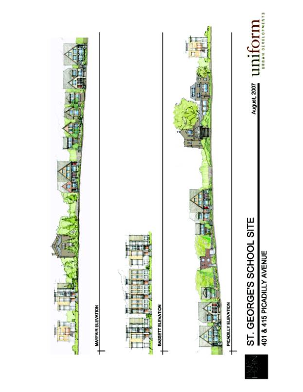
Document 6 Proposed Elevations
DISPOSITION
City Clerk’s Branch, Council and Committee
Services to notify the owner (Uniform Urban Developments, 300-117 Centrepointe
Drive, Ottawa, ON K2G 5X3), agent (Barry Hobin & Associates, 63 Pamilla Street, Ottawa, ON K1S
3K7), OttawaScene.com, 174 Colonnade Road, Unit #33, Ottawa,
ON K2E 7J5,
Ghislain Lamarche, Program Manager, Assessment, Financial Services Branch (Mail
Code: 26-76) of City Council’s
decision.
Planning, Transit and the Environment
Department to prepare the implementing by-law, forward to Legal Services Branch
and undertake the statutory notification.
Legal Services Branch to forward the
implementing by-law to City Council.
LOCATION MAP DOCUMENT
1
DETAILS OF RECOMMENDED ZONING DOCUMENT
2
1.
The
subject lands on Document 3 are to be rezoned as follows:
·
Area A: from I1 to R3A[986],
·
Area B: from I1 to I1[987]
·
Area C: from R3G to I1[987]
·
Area D: from I1 to R3A[988]
·
Area E: from R3G to R3A[988]
The following exceptions will be added to Table XV
of the by-law:
2.
Exception [986] for Area A will include the following changes:
1)
despite subclause 176, (2)(i) and (ii) a house in a planned
unit development is considered to have frontage if the land on which it is to
be located after severance abuts a private way that is 3.6 metres wide and has
frontage of at least 3.6 metres,
2)
despite row ix of Table 177, the minimum setback from a
private way is 1.1 metres, and,
3)
despite row xxi of Table 177, the required interior side yard
adjacent to an institutional use is 1.2 metres for the first 21 metres back
from the street and a minimum of 4.2 metres for the remainder.
3.
Exception [987] for Areas B and C will include the following
changes:
1)
the required side yard adjacent to an ecclesiastical residence
is 0.5 metres,
2)
despite row viii of Table 522, a landscaped area of a minimum
of 3.0 metres is not required adjacent to an ecclesiastical residence and its
driveway,
3)
the required interior side yard adjacent to a place of worship
is 4.3 metres,
4)
the parking required for a place of worship is 3.7 spaces per
10 square metres of gross floor area, and
5)
the minimum length of a required parking space is 4.8 metres.
4.
Exception [988] for Areas D and E will include the following
changes:
1)
despite subclause 176(2)(i) and (ii), a house in a planned
unit development is considered to have frontage if the land on which it is to
be located after severance abuts a private way that is 3.6 metres wide and has
a frontage of at least 3.6 metres,
2)
despite row xxi of Table 177, the required interior side yard
is 1.2 metres for the first 21 metres back from the street and a minimum of 5.4
for the remainder, and
3) despite row xxiv of Table 177, the corner side yard is a minimum of 2.0 metres.
ZONING KEY PLAN DOCUMENT
3
CONSULTATION DETAILS DOCUMENT
4
NOTIFICATION AND CONSULTATION
PROCESS
Notification and public consultation
was undertaken in accordance with the Public Notification and Public
Consultation Policy approved by City Council for Zoning By-law amendments. Two public meetings were held in the
community. The first meeting was hosted
by the developer and occurred before the submission of their zoning
application. The second meeting took
place on October 09, 2007, and was hosted by the Ward Councillor. Staff did not attend these meetings.
PUBLIC COMMENTS
Twelve comments were received as a result of the public notification process. Three support the proposal in principle but had some concerns, while the others did not support the project and stated their reasons.
SUMMARY OF PUBLIC INPUT
1.
How
many cars will they bring into the neighbourhood? The increase in housing will
definitely impact on the number of cars using Island Park Drive.
2.
Will the dwellings be suitable for families with children?
3.
Will the developer save the existing trees?
4.
I have no problem with a land swap to give the Church a proper
parking lot.
5.
I have a major concern with the density of the project. The new development should be 22 homes to
match the rest of the neighbourhood, but Uniform is proposing close to
40 homes.
6.
The proposal constitutes a major change from the original
proposal which did not deal with Areas D and E. I believe the proponent should be required to arrange another
public meeting to review the proposal.
7. While generally we believe the proposed changes to be positive for the community our concerns relate to the existing parking problems in the area and ask that the City require adequate parking on the site (i.e., do not grant any cash-in-lieu for the Church or the new housing or other reductions in parking).
8.
We strongly object to variances to allow a 3.0 metre front
yard and 1.2 metre side yard setbacks.
9.
This a walking-centric neighbourhood and pedestrian
friendliness and safety is a major concern.
We're concerned that reducing setbacks will result in buildings being
constructed very close to the sidewalks resulting in them being shaded and
uninviting as a result.
10. The neighbourhood is comprised of primarily two-storey homes with a small number of of three-storey homes. To introduce nine homes along Piccadilly, that are all three-storey homes with minimal green space around them, is not in keeping with the existing neighbourhood.
11. The draft site plan proposal shows two side by side laneways plus two extra parking spaces on Piccadilly beside the rectory. This area has an excessive use of asphalt and I would like to suggest that the developer and the church work together to minimize laneways and extra parking.
12. I would like to suggest that traffic calming measures be incorporated into the Uniform Urban Development proposal at time of construction and not after the fact.
13. I am concerned with the portion of the development north of the church lot. It appears that 23 of the units' laneways empty onto Mayfair, while only three empty on Piccadilly. Has the possibility of having the Piccadilly residences' laneways empty onto Piccadilly been considered?
1 It is determined that the trip generation of the new dwellings is significantly less than the vehicles generated by the former school use at this location. As a result, there will be a decrease in peak hour trips on the local adjacent streets. The City also looked at possible traffic distribution and assumes 50 per cent of traffic would use Mayfair and Richmond and Piccadilly and Richmond, while 50 per cent of traffic would use Bassett and Island Park. The expected 10-13 vehicles in the a.m. and p.m. peak hours at Island Park Drive and Richmond Road do not make a significant impact to the current levels of service at these intersections.
2. All units are ground-oriented and many
contain rear yards.
3. The developer has had an arborist to the site to assess the trees. The developer intends to modify their site plan in an effort to save several large trees, including a heritage butternut tree next to Daybreak House. Recommendation 2 of the report ensures that site plan issues, such as the mature trees, the rear access driveway for the Bassett Lane homes are adequately addressed before the implementing by-law proceeds to City Council.
4. In exchange for acquiring the lands to accommodate parking, the Church severed off a parcel of their site along Bassett Lane to accommodate nine dwelling units.
5. The
proposal at the Committee is for 35 new dwelling units within two seperate
planned unit developments. There are
policies in the Official Plan that promote intensification at the appropriate
location. The Discussion section of
this report details the reasons why this development is compatible with the
adjacent overall community character and, in the long term, promotes the area's
vitality.
In terms of density, if the applicant was to build
a semi-detached dwelling (two units), which is a permitted use in the R3G
subzone, on each of the existing six lots of record facing Mayfair Avenue then
there could potential be 12 homes facing Mayfair with 12 individual driveways. The applicant is proposing 11 units facing
Mayfair and five driveways. In the case
of the Piccadilly frontage, there are 4.5 lots of record that could permit
potentially nine units and nine individual driveways. The site plan shows the
same number of units and only two driveways. The proposal shows a noticeable
decrease in driveways. The increase in
density on site has been achieved by adding units internal to the planned unit
development that front a private way and are not visible from the adjacent
streets.
6. A second public meeting was held in the community on October 09, 2007, to discuss the changes to the development from the initial meeting resulting from the land transfer between the Church and the developer.
7. The
proposal satisfies its parking requirements.
On-site visitor parking is not required under the Zoning By-law for this
development.
8. There
is no variance required for the front yard setback. The proposal meets the minimum 3.0 metre street setback
regulation for a planned unit development.
This is the same setback for a new home if it was built elsewhere along
Mayfair or Piccadilly. The proposed
side yards for this development meet or exceed the minimum side yard
requirements under the current R3G and R1G subzones in the area. The proposed distance between buildings in
the PUD is a minimum of 2.4 metres.
9. As
mentioned above, the 3.0 metre setback is the minimum setback permitted along
the street and throughout a large part of Ottawa. It is not anticipated that this setback will cause undue negative
impact on the amount of sunlight that reaches the sidewalks. The developer is submitting a sun/shadow
study that will be reviewed at the site plan control stage.
10. The
Piccadilly building elevations have not been fully designed, but the developer
intends to stay within the 10.7 metre building height limit of the surrounding
area. Since the grade changes across
the site, the measuirng of storeys is a little confusing as the number of storeys
varies depending on where you look at it.
The current elevations show that most of new homes have sloped roofs
that resemble two-storey homes from the street. The applicant is proposing three-storey, flat-roofed buildings
along Bassett Lane. The proposed
elevations are shown in Document 6.
11. The
issues raised are site plan related and will be addressed at the time of site
plan control approval before the implementing by-law proceeds to City
Council. The applicant still requires
to submit a site plan application that involves a public notification process.
12. As
mentioned earlier, the traffic generated by this development will not make a
significant impact on the levels of service at the Richmond Road and Island
Park Drive intersections. Consequently,
the Department is not requiring that traffic calming measures be incorported
into the approval.
The current traffic congestion problems on Island Park Drive go beyond the scope of this development and it is staff's understanding that the Ward Councillor is initiating steps to address traffic calming measures in this area. She sees this as a separate issue to be dealt with under a separate process and that it is not an issue to be resolved by this proposal.
13. The site plan illustrates that several of the Piccadilly units share a driveway from Mayfair. The Department was told that the reason for this was the change in grades across the site allowed for easier access to the Piccadily units from the east/Mayfair side of the project. Also, establishing individual driveways for the Piccadilly units may result in the loss of vegetation along Piccadilly. The discussion of driveway access is a site plan related matter that can be addressed during the site plan control review stage.
PUBLIC MEETING COMMENTS
The public open house was held at the Fisher Park School on October 09, 2007, and attended by approximately 30 residents. The applicant’s architect indicated the reasons why the proposal had changed from the original plan. The architect spoke on the development’s efforts to de-emphasize garage doors, minimize lane entries, make dwellings street focused, maintain existing trees on the property, where possible and to design buildings that are compatible with existing residences. The architect addressed questions regarding density by reviewing the surrounding R3 zone classifications and indicating that the developer was working within the City’s established infill urban design guidelines. Other issues that were raised included alternative access locations for the Bassett Lane homes, increased traffic as a result of the development, building height and how it will affect sunlight to existing units, and the potential loss of mature trees.
COUNCILLOR’S COMMENTS
Councillor Leadman is aware of this
application.
Councillor Leadman notes
that the main concern is related to the traffic impacts, not only with this
development, but also with others that are currently happening on Wellington
Street and the potential that exists for more. Traffic impacts from development
affects the community and the city as a whole and it is for this reason that
the city should move to monitor the "cumulative" impacts of
development in and around the area.
It
is Councillor Leadman's intention to work with the community, developer and
City to proactively address the concerns that have been raised with traffic in
order to deal with the problem before it escalates.
The West Wellington Community Association provided the following comment:
Thank you for the opportunity to comment on the proposed development on the site of the old St. George’s School. The West Wellington Community Association (WWCA) has been impressed to date with the openness and willingness to accommodate that the developers have shown in the process relating to the St. George’s site.
The WWCA is pleased to see that significant thought has been put into the design of the project to ensure it fits into the neighbourhood and is aesthetically pleasing. For example, the efforts to place as many of the garages as possible in the back of the houses is commendable.
With respect to the request for re-zoning and minor variances requested under this application, it is our Association’s understanding that the variances requested relate primarily to Uniform’s desire to have as many garages and driveways accessible from the back of the properties. We appreciate the developer’s efforts to reduce the number of driveways facing the street and as a result support this application.
With respect to the request to allow interior units that back onto the parking lot to have shorter back-yards, this too seems reasonable considering there is no immediate neighbour to the South.
Our Association would like to take advantage of this application to make the city aware of the more general comments we have with respect to the development as a whole.
As a community association, our primary goal is to ensure that local residents are given frequent and meaningful opportunities to influence developments in our catchment area. In the case of the proposed development on the St. George’s site, we would like to commend Uniform Development and Barry Hobin for the efforts they have already made to involve the community in the development plan, particularly with their negotiations with St. George’s Catholic Church in obtaining a satisfactory result. However, we urge them to continue to solicit detailed input into the design phase of the project directly from the residents who will be most affected by the development – the residents of Mayfair and Piccadilly between Bassett Lane and Wellington Street.
We would also like to commend the developers for seemingly having made significant efforts to preserve healthy, mature trees. Mature trees add considerably to the overall value of the development and have obvious benefits for the community.
The pace of development in the West Wellington area has been staggering over the past few years and our association has significant concerns about increasing traffic. Increased development has brought new vitality to the neighbourhood but has also significantly increased traffic and overall congestion in the area.
In the immediate area of this proposed development, we have recently seen the construction of the Island Park carwash with two commercial spaces, and the current construction of the Piccadilly condominium complex that will contain significant retail space and 42 residential units. One can assume that between the carwash and the Piccadilly, 40 to 50 more cars will be added to the immediate area. The proposed development of the St. George’s property will undoubtedly double that number. One can also assume that between The Piccadilly and St. George’s site, at least 200 more people, many of them children, will move into this small block.
If significant traffic management measures are not put in place to control this new volume and ensure the safety of residents – especially children – there is significant potential that serious accidents will occur. Our Association strongly encourages the City administration and the ward Councillor Ms. Leadman, to take the lead in the development and implementation of measures to calm traffic on these two blocks, including examining initiatives such as of the installation of bump-outs, closing off Basset Lane at the West Corner of Piccadilly and/or making both blocks one-way streets.
Sidewalks are another element related to safety. At present, there are no sidewalks along either side of Bassett lane. The increased presence of pedestrians due to the new residences along Bassett dictates that for safety reasons as well as aesthetics, the construction of a sidewalk between Piccadilly and Mayfair is desirable. Since there will be major road works associated with the construction of the residences, it makes sense to take advantage of the opportunity to build a sidewalk. We assume that this addition would also be a desirable selling feature for the developer.
Although the implementation of traffic calming measures and the construction of a sidewalk may be costly, our Association feels that they are not only necessary but that the City should be funnelling some of the significant tax revenue generated by these new projects, as well as funds that have been generated from cash in lieu of parking, back into the immediate area.
Finally, although at this stage we are supportive of this particular development, we would like to reiterate our opposition to the initial decision by Ottawa school boards to close this and other inner city schools to sell these properties to the highest bidder. Further we strongly object to the City’s willingness to change the zoning on these types of properties from institutional to residential development uses. It is the WWCA’s view, that schools such as St. George’s school are key elements in creating and maintaining the appeal and vibrancy of City neighbourhoods.
We strongly encourage the City to work with both the public and Catholic school boards to rethink this approach and in worse case scenarios to ensure that when schools are absolutely forced to close, that the building and school grounds remain in public hands for other community-based uses. It is short sighted on the part of school boards and the City to proceed in this manner. The sale of these community spaces into private hands will foreclose on our densely packed community’s future ability to convert these properties back again for school uses once demographic shifts inevitably occur.
Response:
As mentioned above, it is our understanding that the Ward Councillor sees traffic calming measures in this vicinity as a separate issue to be dealt under a separate process and that it is not an issue to be resolved by this proposal.
The issue of sidewalks along Bassett Lane will be dealt with during the site plan control review process.
PROPOSED SITE PLAN DOCUMENT 5
PROPOSED ELEVATIONS DOCUMENT 6