|
2. ZONING - 5985 RENAUD ROAD ZONAGE - 5985, CHEMIN RENAUD |
Committee recommendation
(This application is subject
to Bill 51)
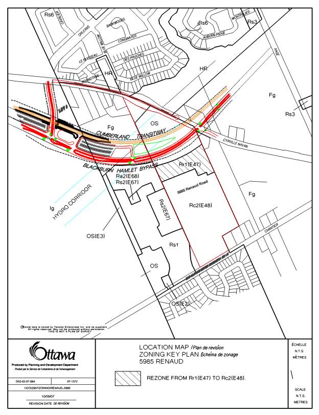
That Council approve an amendment to the former City of Gloucester Zoning By-law to change the zoning of part of 5985 Renaud Road from Residential Row Dwelling 1 Zone Exception 47 (Rr1(E47)) to Mixed Residential Dwelling 2 Zone Exception 48 (Rc2(E48)) as shown in Document 1.
Recommandation du Comité
(Cette demande est
assujettie au Règlement 51)
Que le Conseil approuve une modification au Règlement de zonage de l’ancienne Ville de Gloucester afin de changer la désignation de zonage d’une partie du 5985, chemin Renaud de Zone résidentielle de maisons en rangée 1, exception 47 (Rr1(E47)) à Zone résidentielle mixte 2, exception 48 (Rc2 (E48)), tel qu’il est indiqué dans le document 1.
Documentation
1.
Deputy
City Manager's report Planning, Transit
and the Environment dated 26 October 2007 (ACS2007-PTE-APR-0204).
Report to/Rapport au :
Planning and Environment Committee
Comité de l'urbanisme et de l'environnement
and Council / et au Conseil
26 October 2007 / le 26 octobre 2007
Submitted by/Soumis par : Nancy Schepers, Deputy City Manager
Directrice municipale adjointe,
Planning, Transit and the Environment
Urbanisme, Transport en commun et Environnement
Contact Person/Personne ressource : Karen Currie,
Manager / Gestionnaire, Development Approvals / Approbation des demandes
d'aménagement
(613) 580-2424, 28310 Karen.Currie@ottawa.ca
|
SUBJECT: |
|
|
|
|
|
OBJET : |
REPORT RECOMMENDATION
That the Planning and Environment Committee recommend Council approve an amendment to
the former City of Gloucester Zoning By-law to change the zoning of part of
5985 Renaud Road from Residential Row Dwelling 1 Zone Exception 47 (Rr1(E47))
to Mixed Residential Dwelling 2 Zone Exception 48 (Rc2(E48)) as shown in
Document 1.
RECOMMANDATION DU RAPPORT
Que le Comité de l’urbanisme et de l’environnement
recommande au Conseil d’approuver une modification au Règlement de zonage de l’ancienne
Ville de Gloucester afin de changer la désignation de zonage d’une partie du
5985, chemin Renaud de Zone résidentielle de maisons en rangée 1, exception 47
(Rr1(E47)) à Zone résidentielle mixte 2, exception 48 (Rc2 (E48)), tel qu’il
est indiqué dans le document 1.
BACKGROUND
The subject lands, 5985 Renaud Road, are located north of Renaud Road and west of Navan Road in the East Urban Community. More specifically, they are bordered to the north by Navan Road, to the east by existing residential homes, to the west by a proposed residential subdivision to be developed by DCR Phoenix and to the south by a developing residential community by Valecraft Homes, Monarch Homes and Claridge Homes. The future Transitway/Blackburn Hamlet By-Pass splits the subject lands into two parts, one fronting on Navan Road and the other fronting on Renaud Road. A Draft Plan of Subdivision was approved in March 2005 for the southerly part of the subject lands.
Purpose of
Zoning Amendment
Due to changes in the road layout for the adjacent westerly proposed plan of subdivision, the approved draft plan of subdivision for the subject lands has been revised to replace private roads with public roads along the north end of the site, immediately south of the future Transitway. In order to allow townhomes on a public road, a different zone is required.
The second purpose of the application is to rezone the lands north of the future transitway to allow a residential development consisting of street row dwellings along Navan Road.
The north end of the draft plan of subdivision is zoned Row Dwelling Zone Exception 47 (Rr1(E47)), which allows for row dwellings on a private road.
The lands north of the future Transitway are zoned Open Space Zone (OS), which allows for uses such as outdoor recreational uses, conservation uses, public parks, etc.
DISCUSSION
Official Plan
The property is designated as “General Urban Area”. The purpose of this designation is to
facilitate a broad scale of uses, particularly a full range of housing types,
as well as employment and shopping facilities. The designation is used to
promote the development of sustainable communities at increased densities in a
manner that enhances and complements the desirable characteristics and ensures
the long term vitality of the communities.
The north portion of the property is also designated as Developing
Community. This designation promotes a
full range of choice in housing, commercial, institutional and leisure
activities within a development pattern that prioritizes walking, cycling and
transit over the automobile. The
completion of a Community Design Plan (CDP) will be required prior to any
development being approved in a developing community.
Proposed Zoning
The Department supports, in part, the proposed Zoning By-law application.
The proposed rezoning for the north end of the draft plan of subdivision conforms with the intent of the “General Urban Area” policies in terms of types of uses and location to transit. It will contribute to the mix of housing types in the overall neighbourhood and will provide the increased density in close walking distance to the future Transitway. The replacement of the private roads with public roads will allow for public acccess to the Transitway.
Staff cannot support the rezoning of the lands north of the
future Transitway at this time. The
subject lands are currently un-serviced and no Community Design Plan has yet been completed for that area. It is anticipated that these lands will be
addressed as part of the Phase II of the East Urban Community Design Plan
(EUCDP). Staff would also like to point
out that the vast majority of the lands fall under the hydro corridor. Moreover, the Phase I EUCDP Report shows
that the small portion of developable lands north of this hydro corridor are
constrained by significant slopes and setbacks requirements from Mud
Creek. Finally, the applicant has not
demonstrated how the lands can be developed for townhomes in the face of these
constraints. As a result, the lands
north of the Transitway corridor will not be dealt with at this time, and will
be brought forward to Planning and Environment Committee for approval at a future
date, once the CDP is completed.
CONSULTATION
Notice of this application was carried out in accordance with the City's Public Notification and Consultation Policy. The Ward Councillor is aware of this application and the staff recommendation. The City did not receive any negative comments or opposition to this application.
FINANCIAL IMPLICATIONS
APPLICATION PROCESS
TIMELINE STATUS
This application was processed by the "On Time
Decision Date" established for the processing of Zoning By-law amendment
applications.
SUPPORTING DOCUMENTATION
Document 1 Location
Map
DISPOSITION
City Clerk’s Branch, Committee and Council
Services to notify the owner, Jean-Guy Rivard, 1455 Youville Drive, Suite 216,
Orleans, Ontario, K1C 6Z7, applicant, Deborah Belfie, 21 Pinecone Trail,
Stittsville, Ontario, K2S 1E1, OttawaScene.com, 174 Colonnade Road, Unit #33, Ottawa,
ON K2E 7J5,
Ghislain Lamarche, Program Manager, Assessment, Financial Services Branch (Mail
Code: 26-76) of City Council’s
decision.
Planning, Transit and the Environment
Department to prepare the implementing by-law, forward to Legal Services Branch
and undertake the statutory notification.
Legal Services Branch to forward the implementing
by-law to City Council.
LOCATION MAP DOCUMENT
1