|
6. ZONING - 3500 JOCKVALE ROAD ZONAGE - 3500,
CHEMIN JOCKVALE |
Committee recommendation
(This application is subject
to Bill 51)
That Council approve an amendment to the
former Nepean Zoning By-law to change the zoning at 3500 Jockvale Road from FG
- Future Growth to RMU - Residential Mixed Unit, RMU (H) Block 25 - Residential Mixed Unit (Holding)
(Exception -25) Zone and PRP - Parks and Recreation Zone (Public) as shown in
Document 1 and as detailed in Document 2.
Recommandation du Comité
(Cette demande est
assujettie au Règlement 51)
Que le
Conseil approuve une
modification au zonage de l'ancienne Ville de Nepean visant à faire passer la
désignation de zonage de la propriété située au 3500, chemin Jockvale, de FG
(zone de croissance future), à RMU (zone à utilisation résidentielle mixte);
RMU (H), pièce 25 (zone à utilisation résidentielle mixte (zone résidentielle
de réserve) (exception 25)); et PRP (zone de parcs et loisirs (publique)),
comme l'illustre le document 1 et le précise le document 2.
Documentation
1.
Deputy
City Manager's report Planning, Transit
and the Environment dated 15 November 2007 (ACS2007-PTE-APR-0213).
Report to/Rapport au :
Planning and
Environment Committee
Comité de l'urbanisme et de l'environnement
15 November 2007 / le 15 novembre 2007
Submitted by/Soumis par : Nancy Schepers, Deputy City Manager/
Directrice municipale adjointe,
Planning, Transit and the
Environment/Urbanisme, Transport en commun
Contact Person/Personne ressource : Karen Currie, Manager, Development
Approvals
Planning
Branch/Direction de l'urbanisme
(613)
580-2424 x 28310, karen.currie@ottawa.ca
SUBJECT:
|
|
|
|
|
OBJET :
|
REPORT RECOMMENDATION
That the Planning and Environment Committee recommend Council approve an amendment to the former Nepean Zoning By-law to change the zoning at 3500 Jockvale Road from FG - Future Growth to RMU - Residential Mixed Unit, RMU (H) Block 25 - Residential Mixed Unit (Holding) (Exception -25) Zone and PRP - Parks and Recreation Zone (Public) as shown in Document 1 and as detailed in Document 2.
RECOMMANDATION DU RAPPORT
Que le Comité de l'urbanisme et de
l'environnement recommande au Conseil d'approuver une modification au zonage de
l'ancienne Ville de Nepean visant à faire passer la désignation de zonage de la
propriété située au 3500, chemin Jockvale, de FG (zone de croissance future), à
RMU (zone à utilisation résidentielle mixte); RMU (H), pièce 25 (zone à
utilisation résidentielle mixte (zone résidentielle de réserve) (exception
25)); et PRP (zone de parcs et loisirs (publique)), comme l'illustre le
document 1 et le précise le document 2.
BACKGROUND
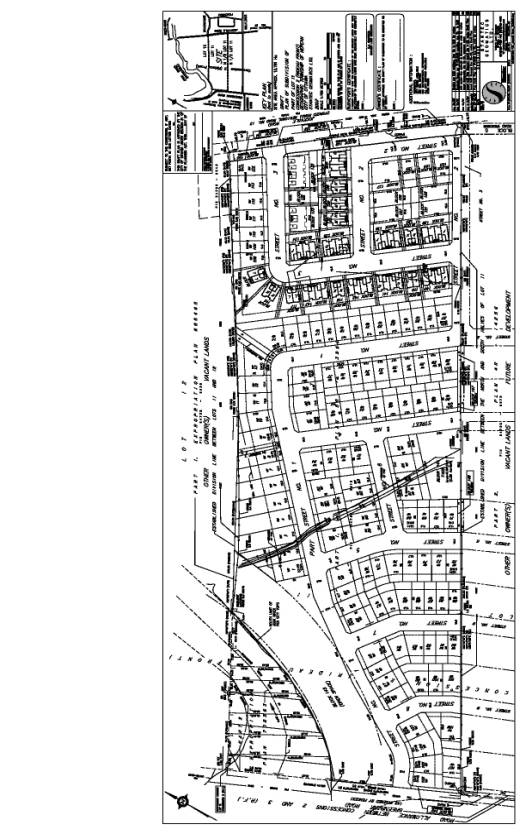
This
application applies to 12.78 hectares of land, located south of the Nepean Town
Centre and the Jock River, east the existing Greenbank Road alignment and west
of Jockvale Road. The proposed
subdivision is referred to as the
"Half Moon Bay Subdivision" (see Document 1).
The
subject lands lie within a larger area, which was the subject of a Community
Design Plan (CDP) that received Council approval in June 2006. The Barrhaven South CDP provides planning
direction for development applications within the South Nepean urban community.
This
Zoning By-law application will implement the objectives of the CDP for the
lands that lie within Phase 1 of that plan. The site is vacant and currently
used for agricultural purposes. There is a drainage ditch running south to
north through the site. Surrounding the
site are mainly vacant lands planned for future development. To the north is the Jock River corridor with
adjacant land owned by the City and proposed to be developed as a linear
district park connected by a natural
trail system along the south side of the corridor, and linking to Half
Moon Bay and the Mattamy Subdivision to the west. The City's land also contains a designated "Urban Natural
Area" (UNA) significant wood lot and to the south of the woodlot is the site of a future stormwater management
pond. To the southeast of the site is
the existing Stonebridge Community.
Purpose
of Zoning Amendment
The
Zoning By-law amendment will allow for the development of a subdivision
comprising of approximately 200 residential units in the form of
single-detached, semi-detached and street townhouse units, conservation/open
space lands and a neighbourhood park.
The
application is to change the existing zoning from Future Growth - FG Zone to
the following proposed zone categories:
Residential Mixed Unit - RMU, Residential Mixed Unit Holding - RMU(H)
Block 25 - Residential Mixed Use Holding (Exception 25), and Parks and
Recreation Public - PRP Zone. A
companion subdivision application is being processed that includes
approximately 114 lots, 29 blocks for semi-detached and street townhouse units,
one neighbourhood park and one linear open space block along the Jock River.
DISCUSSION
The lands are designated as General Urban Area in the Official Plan and are located in Phase 1 of the Barrhaven South Community Design Plan (CDP). The CDP requires that both low and medium density residential units and a portion of the district park and a neighbourhood park be developed on the subject lands. The CDP also identifies a significant portion of the property as being within the 100-year flood plain.
Details of Proposed Zoning
The Zoning By-law amendment proposes the following four zone categories for the lands affected by this application, with further detail provided in Document 2:
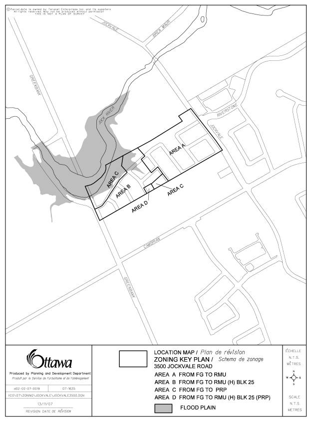
- Residential Mixed Unit - RMU Zone for a portion of the residential lands identified as Area A in Document 3. Unit types permitted in the RMU zone will include single, semi-detached and multiple attached units.
- Residential Mixed Unit (Holding) (Exception) - RMU (H) Block 25 Zone for the lands that mainly represent Phase 2 of the proposed subdivision and are impacted by the existence of the flood plain. This area is identified as Area B on the Document 3 along with the flood plain overlay. The exception zone is necessary to identify the conditions that must be met prior to the Holding symbol being removed.
- Parks and Recreation Public - PRP Zone applicable to the two parks planned for the subdivision, identified as Area C in Document 3.
- Dual Zone of a Residential Mixed Unit (Holding) (Exception) and Parks and Recreation Public - RMU (H) Block 25(PRP) Zone is applicable to a small area on the western edge of the neighbourhood park. This area is identified as Area D on Document 3.
Concurrent Application
The concurrent application for subdivision approval is being reviewed.
The Department supports the Zoning By-law amendment application because it is in conformity with the Official Plan and the Barrhaven South Community Design Plan in terms of development pattern, housing mix and density.
ENVIRONMENTAL IMPLICATIONS
The application of a holding provision for the zoning of the residential areas located in the flood plain will ensure no development occurs in the floodplain until all required approvals have been given. The Corrigan Municipal Drain will be enclosed and fish habitat compensation measures will be implemented following acquisition of necessary approvals in other areas of the Barrhaven South Community.
CONSULTATION
Notice of this application was carried out in accordance with the City’s Public Notification and Consultation Policy. The Ward Councillor is aware of this application and the staff recommendation.
A public meeting as required for the subdivision application was held on October 4, 2007 and many of the questions surrounded the layout of the plan. The City did not receive any negative comments or opposition to this application from the public; however, comments were received from the City’s Parks and Recreation Branch. They oppose the proposed back lotting along a portion of the District Park. As well, they believe that there is an under-dedication of parkland pursuant to the CDP, and therefore, the neighbourhood park should be increased in size to not only meet the dedication requirements, but also to provide a better configuration of the park. Staff have reviewed and are addressing these issues through the subdivision application process and the implementation of a Holding zone on the Phase 2 lands and the dual zone adjacent to the park. These measures will provide an ability to address the Branch’s comments.
FINANCIAL IMPLICATIONS
The proposed development does not require an expenditure of municipal funds over and above those funds recovered by development charges or for which an allocation has been made in a Council approved budget.
SUPPORTING DOCUMENTATION
Document 1 Location Map
Document 2 Details of Recommended Zoning
Document 3 Draft Zoning Key Plan
Document 4 Draft Plan of Subdivision
DISPOSITION
City Clerk’s Branch, Council and Committee Services to notify the owner, Ted Phillips, McNeil Farm Limited, 225 Metcalfe Street, Ottawa, K2P 1P9, OttawaScene.com, 174 Colonnade Road, Unit #33, Ottawa, ON K2E 7J5, Ghislain Lamarche, Program Manager, Assessment Financial Services Branch (Mail Code: 26-76) of City Council’s decision.
Planning, Transit and the Environment Department to prepare the implementing by-law, forward to Legal Services Branch and undertake the statutory notification.
Legal Services Branch to forward the implementing by-law to City Council.
LOCATION MAP DOCUMENT
1

DETAILS OF RECOMMENDED ZONING DOCUMENT
2
1. A new exception, Block 25, will be added to clause 6:5RMU:3 including the following special provisions:
a) On any land zoned RMU Block 25 that includes a holding symbol (H), the following must be done prior to the removal of the holding symbol:
(i) Approval of Cut and Fill Application by the Rideau Valley Conservation Authority and the City of Ottawa;
(ii) Draft approval of a plan of subdivision;
(iii) All conditions which affect the design of the plan of subdivision have been cleared.
2. Schedule B21 will be amended as follows and as shown on Document 1:
a) Area A rezoned from FG to RMU;
b) Area B rezoned from FG to RMU(H)Blk 25;
c) Area C rezoned from FG to PRP;
d) Area D rezoned from FG to RMU(H)Blk 25(PRP)
e) flood plain overlay removed from Area B.
DRAFT ZONING KEY PLAN DOCUMENT
3
DRAFT PLAN OF SUBDIVISION DOCUMENT
4