|
2. ZONING - 1445 MERIVALE ROAD
ZONAGE
- 1445, CHEMIN MERIVALE
|
Committee
recommendationS AS AMENDED
(This application is subject
to Bill 51)
1. That Council approve
an amendment to the former City of Nepean Zoning By-law to change the zoning of
1445 Merivale Road from CO – Commercial Office Block 8 to a MMU – Merivale
Mixed Use Exception Zone as shown in Document 1 and as detailed in Document 4.
2. Whereas access and egress for 1445 Merivale
Road via Burris Lane is a major concern for the surrounding community.
THEREFORE Be it resolved that should the
application for rezoning be approved staff be directed to consider a Site Plan
with access and egress on Merivale Road.
AND THAT
if such access is considered not desirable that it be subject to a report to
the Transportation Committee.
RecommandationS modifiÉeS du Comité
(Cette demande est
assujettie au Règlement 51)
1. Que
le Conseil approuve une modification du Règlement de zonage de l’ancienne Ville
de Nepean afin de changer le zonage du 1445, chemin Merivale de Zone de bureaux
commerciaux (CO) – bloc 8 à Zone à usages mixtes de Merivale avec exception,
comme le présente le document 1 et l’explique le document 4.
2. Atttendu que l’entrée et la sortie du 1445,
chemin Merivale qui donnent sur la ruelle Burris sont une préoccupation
importante pour la communauté des environs.
Il est par conséquent résolu
que si la demande de rezonage est approuvé,
le personnel devra examiner un plan d’aménagement doté d’une entrée et d’une
sortie qui donnent sur le chemin Merivale.
ET QUE si l’on détermine qu’une
telle entrée n’est pas appropriée, un rapport sera déposé à cet effet auprès du
Comité des transports.
Documentation
1.
Deputy
City Manager's report Planning, Transit
and the Environment dated 20 December 2007 (ACS2008-PTE-PLA-0009).
2.
Extract
of Draft Minutes, 8 January 2008.
Report to/Rapport au :
Planning and Environment Committee
Comité de l'urbanisme et de l'environnement
and Council / et au Conseil
20 December 2007 / le 20 Decembre 2007
Submitted by/Soumis par : Nancy Schepers, Deputy City Manager
Directrice municipale adjointe,
Planning, Transit and the Environment
Urbanisme, Transport en commun et Environnement
Contact Person/Personne ressource : Karen Currie,
Manager / Gestionnaire, Development Approvals / Approbation des demandes
d'aménagement
(613) 580-2424, 28310 Karen.Currie@ottawa.ca
|
|
Ref N°: ACS2008-PTE-PLA-0009
|
|
SUBJECT:
|
ZONING - 1445 Merivale road (fILE NO.
d02-02-07-0077)
|
|
|
|
|
OBJET :
|
ZONAGE - 1445, chemin Merivale
|
REPORT RECOMMENDATION
That the Planning and
Environment Committee recommend Council approve an amendment to the former City
of Nepean Zoning By-law to change the zoning of 1445 Merivale Road from CO
– Commercial Office Block 8 to a MMU – Merivale Mixed Use Exception Zone as
shown in Document 1 and as detailed in Document 4.
RECOMMANDATION DU RAPPORT
Que le Comité de recommande au Conseil
d’approuver une modification du Règlement de zonage de l’ancienne Ville de
Nepean afin de changer le zonage du 1445, chemin Merivale de Zone de bureaux
commerciaux (CO) – bloc 8 à Zone à usages mixtes de Merivale avec exception,
comme le présente le document 1 et l’explique le document 4.
BACKGROUND
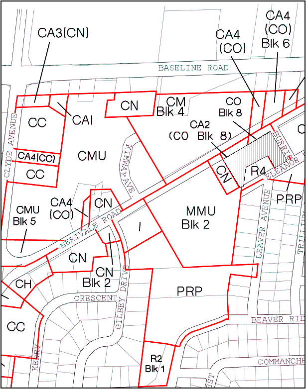
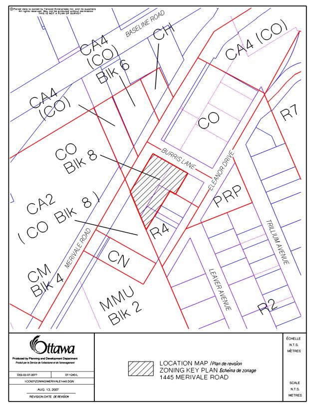
The subject property is located
on the east side of Merivale Road immediately south of Burris Lane (see
Document 1). The site is approximately
55 metres wide and 49 metres deep.
The area of the site is
approximately 3210 square metres. The
surrounding properties contain a mix of uses including low density residential
to the east, and commercial to the north, south, and west.
A motorcycle retailer and large
format grocery store are located on the west side of Merivale Road, while a
three-storey office building occupies the north side of Burris Lane. Approximately 100 metres to the south
is a shopping outlet, which contains a number of retailers including a grocery
store, drug store, restaurant, etc. In
general, the area is dominated by asphalt parking lots that flank Merivale
Road. Buildings are typically setback
away from the street. For the most part
landscaping is sparse along this segment of Merivale Road. Behind this site exists an established
residential neighbourhood.
Purpose of
Zoning Amendment
The purpose of this application is to amend the Zoning
By-law to permit a 450-square metre fast food restaurant and parking lot. The revised concept plan provided in support
of the application sites a one-storey building at the corner of Merivale Road
and Burris Lane, with parking facilities to the rear and side of the building
(see Document 4). Vehicular access is
proposed to be from Burris Lane. The
owner has established that it wishes to maintain some zoning flexibility to
accommodate potential market demands.
If the proposed fast food restaurant proves unviable the owner would
also like to be able to market the site for retail uses.
Existing
and Proposed Zoning
The property is zoned Commercial
Office (CO) Block 8. This zone permits
a number of uses including business office, bank, day nursery and private
club. The Block 8 provision restricts
development from occurring until all of the lands delineated in Schedule B7 of
the Zoning By‑law are assembled under single ownership (see Document
2). At present the CO Block 8 Zone does
not support restaurant or retail uses.
According to the applicant, the property
owner has attempted to acquire the entirety of Block 8 for several
decades. Although the owner has not
been able to attain the full block, it recently increased its landholdings. This most recent acquisition has prompted
the proposed Zoning By‑law amendment, as the owner now believes that it
maintains sufficient property within Block 8 to accommodate a fast food
restaurant. To facilitate the proposed
use it is recommended that the site’s zoning be amended from ‘CO Block 8’ to a
Merivale Mixed Use (MMU) Exception Zone.
The MMU Zone permits a wide variety of uses including residential.
DISCUSSION
Official Plan
The Official Plan provides a
vision of the future growth of the city and a policy framework to guide its
physical development. The Plan is not a
tool to limit growth but rather to anticipate change, manage it and maintain
options. According to Schedule B of the Official Plan,
the subject property is designated ‘Arterial Mainstreet’.
Specific policies related to this designation
are outlined in Section 3.6.3 of the Plan.
Larger lots, varied setbacks, and lower densities are characteristic of
Arterial Mainstreets. Streets carrying
this designation often contain four or more traffic lanes, and do not typically
support on-street parking. Parking is
usually provided in lots located between buildings and the street. At present, Arterial Mainstreets typically
house single-purpose commercial buildings.
Overtime, Arterial Mainstreets are expected to
evolve into more compact places that provide a mix of pedestrian friendly
uses. Arterial Mainstreets are also
envisioned to support high-quality public transit and cycling routes.
Merivale Road Secondary Plan
The property is also subject to the
provisions of the Merivale Secondary Plan.
This Plan was first prepared in 1982 and updated in 1998. The 1998 version acknowledges that the
former vision outlined for the area never was fully realized; Merivale Road has
not become a competitive location for office buildings. Today’s Plan further recognizes that
automobile-oriented retail uses will likely continue to dominate the area for
some time. Unlike the original Plan,
today’s version introduces an alternative land use approach that focuses on
enhancing urban design rather than controlling land
uses. The Plan continues to support
a broad range of retail uses, but has also been expanded to include additional
varied uses such as residential. The intent of the
most recent Plan is to improve the area as a place to shop, work, and live by
enhancing the relationship between retail, employment, and residential
uses. The
Plan also strives to improve Merivale Road’s ability to efficiently provide
access to all modes of travel including trips made by pedestrians and cyclists,
as well as by automobiles and buses.
Analysis
Generally speaking, the Zoning By-law regulates
the type, scale and location of land uses within a property. With respect to type, ‘fast food restaurant’
and ‘retail’ uses are permitted in areas designated Arterial Mainstreet within
the Official Plan. They are also in
accordance with the Merivale Secondary Plan.
In support of the Merivale Secondary Plan, the Department
recommends that a MMU Exception Zone be applied to the site because of its
extensive list of permitted uses. It
should be noted that the applicant’s original request detailed a fast food
restaurant with drive-though use. In
response to concerns raised by the Department and community the owner has
agreed to remove the drive-through component from its proposal.
In terms of scale,
the proposed one-storey building has a smaller footprint than many of the
area’s retail and commercial buildings.
According to the concept plan, the building is expected to occupy
approximately 13 per cent of the site. The
scaling of the building’s Mainstreet façade is encouraging from an urban design
perspective because it covers more than 50 per cent of the lot within three
metres of the front lot line. With
respect to height, the building is not expected to greatly exceed that of
neighbouring dwellings. In contrast,
the CO Block 8 Zone permits a building that occupies up to 40 per cent of the
site (1284 square metres on ground floor), with a potential height of 18.3
metres. This uniformity in scale is
desirable, since the proposed restaurant and existing dwellings will occupy the
same block. The proposed MMU Zone
permits a floor area ratio of 0.33 (total of 1059 square metres of
development).
With respect to parking a total of 45 spaces
(one per 10 square metres) have been proposed, whereas the current requirement
is 73 spaces (one per 6.2 square metres).
The chosen rate corresponds with the New Comprehensive Zoning
By-law. While the new by-law has not
been formally established, the Department is satisfied that the amount of
parking supplied is sufficient to accommodate a fast food restaurant. In addition, the area is served by frequent
and multiple public transit opportunities.
Although additional parking can be accommodated
on site, the Department believes that the need for landscaping supersedes the
requirement for extra parking.
Permitting a decrease in the number of required surface parking spaces
also helps to achieve the Official Plan’s policies in support of compact urban
environments.
The owner has requested permission to reduce
parking stall lengths to 5.2 metres, instead of the required 6.0 metres. This standard reflects the New Comprehensive
Zoning By Law and is presently the standard applied in other parts of the
city. With this, aisle widths have been
increased from the required 6.0 metres to 6.7 metres. When combined, the stall length and aisle width total 11.9
metres, resulting in a 0.1-metre deviation from the Nepean Zoning By-law.
In terms of the location of land
uses, the proposal incorporates a zoning envelope that respects adjacent
residents and corresponds to the City’s broader policy objectives. The current proposal includes a three-metre
buffer around the entire parking lot, to ensure that adequate space is
available for vegetation along the edges of the site and fencing along the rear
property line. This application has
allowed the Department to significantly increase the amount of buffer space
required between the proposed parking lot and rear property. The current zone requires between 0 and 1.5
metres of landscaped area, whereas the proposed zoning establishes a 3.0-metre
setback.
Unlike other Merivale Road
developments the parking lot has been located 3.0 metres beyond the building’s
Mainstreet façade. It is important to
note that the City is acquiring a 4.75 metre strip of land adjacent to Merivale
Road to accommodate a possible future road widening. Effectively, the amount of buffer space available along Merivale
Road increases accordingly until the roadway is widened. Presently there are no future plans to widen
this segment of Merivale Road.
Therefore the total amount of buffer space between the proposed parking
lot and existing sidewalk is over 7.0 metres, which is greater than surrounding
commercial properties. Similar to the
privately owned portions of the site, the City will be exploring opportunities
to landscape these public portions of the property through its Site Plan
Control Review process.
In terms of building location,
the Department is in support of the proposed 0 metre setback along the
Mainstreet. The current zoning requires
a three-metre front yard setback, while the Applicant’s original request
detailed a four-metre setback.
Situating the building adjacent to the front property line not only provides
added space for landscaping at the rear of the site, but also supports numerous
Official Plan and Secondary Plan policies.
A 0-metre setback also permits a greater separation between the proposed
building and neighbouring residential uses.
A generous setback between the building and rear lot line will ensure
that neighbours maintain sun exposure and unobstructed sight lines.
Conclusion
In light of the above, the
Department is recommending that the Planning and Environment Committee approve
this request to amend the Zoning By-law.
CONSULTATION
Notice
of this application was carried out in accordance with the City's Public
Notification and Consultation Policy. The
Ward Councillor is aware of this application and the staff recommendation. Numerous comments were
received from the public and are provided in Document 5.
APPLICATION PROCESS
TIMELINE STATUS
This application was not processed by the “On
Time Decision Date” established for the processing of Zoning By-law amendment
applications due to a public meeting held on October 15, 2007, and
subsequent updates to the proposed concept plan.
FINANCIAL IMPLICATIONS
N/A
SUPPORTING DOCUMENTATION
Document 1 Location
Map
Document 2 Schedule B7
Document 3 Site Concept
Document 4 Details
of Recommended Zoning
Document 5 Consultation
Details
DISPOSITION
City Clerk’s Branch, Council and
Committee Services to notify the Owner, J. Michael Casey, 1801 Woodward Drive, Ottawa, Ontario, K2C 0R3, Applicant, Brian Casagrande, 233 McLeod Street Ottawa, Ontario
K2P 0Z8, OttawaScene.com, 174 Colonnade Road, Unit 33, Ottawa,
ON K2E 7J5,
Ghislain Lamarche, Program Manager, Assessment, Financial Services Branch (Mail
Code: 26-76) of City Council’s
decision.
Planning, Transit and the Environment
Department to prepare the implementing by-law, forward to Legal Services Branch
and undertake the statutory notification.
Legal Services Branch to forward the
implementing by-law to City Council.

SITE CONCEPT (November 14, 2007) DOCUMENT
3
DETAILS OF RECOMMENDED ZONING DOCUMENT
4
1445 Merivale Road
A new MMU Exception zone will be added to 7:10:3 and will
include the following special permitted uses and provisions:
- Fast
food restaurant excluding drive-through
- A
0-metre building setback along the front lot line abutting Merivale Road
- A
3.0-metre minimum setback for a parking lot and any parking space from any
lot line
- A
2.5-metre front lot line setback abutting Burris Lane
- Reduction
to parking stall length to 5.2 metres
- Ingress
and egress directly and from every parking space must be by means of a
driveway, land or aisle having a width of at least 6.7 metres
- Parking
rate reduction to one per 10 square metres of gross floor area
CONSULTATION DETAILS
DOCUMENT 5
NOTIFICATION AND CONSULTATION PROCESS
Notification and public consultation
was undertaken in accordance with the Public Notification and Public Consultation
Policy approved by City Council for Zoning By-law amendments. A public meeting was also held in the
community on October 15, 2007.
PUBLIC COMMENTS
The Planning, Transit and
Environment Department has not received any commentary in support of the
proposed Zoning By-law amendment.
Dozens of formal complaints have been submitted in response to the
proposal, in addition to a petition signed by approximately 80 area residents.
SUMMARY OF PUBLIC INPUT
A number of issues were raised in
response to the circulation of this application. Citizens have voiced concerns over the establishment of a fast
food restaurant. Many believe that
there are too many restaurants in the area and that another restaurant will
worsen traffic. In addition to traffic
concerns, some residents believe that a fast food restaurant contravenes
policies in support of the diversification of Merivale Road. Residents have indicated that they would
rather the site be developed with one of the uses permitted under the current
CO Block 8 Zone. Citizens were also
concerned at the prospect of a potential drive-through facility because of its
impact on traffic levels, pedestrian safety, and human health.
Many residents are opposed to the
location of the proposed site access (via Burris Lane). Most residents would prefer to replace the
proposed access with a right in/right out access via Merivale Road. Many believe that a fast food restaurant
will generate more traffic than can be safely accommodated on Burris Lane. There is concern that providing access from
Burris Lane will increase the amount of cut-though traffic into the adjacent
residential neighbourhood. Residents
also believe that the proposed access will jeopardize the safety of the many
pedestrians whom utilize Burris Lane to gain access to Merivale Road. A number of secondary concerns related to
noise, pollution, odour, and sewage were also raised. An in depth summary of concerns follows.
Concern: Area traffic has been cited
as a major problem, particularly along Merivale Road and throughout the
residential community. There is concern
that the proposal will worsen area traffic, particularly along Burris
Lane. It has also been suggested that
the applicant’s traffic study is flawed because it does not consider added traffic
impacts created by the Merivale Market development (shopping outlet containing
Food Basics).
Response: Merivale
Road is classified as an ‘Arterial Road’ within the City’s Official Plan. Arterial roads are designed to carry heavy
volumes of traffic over long distances.
They function as the City’s major public corridors and therefore
accommodate traffic generated by all forms of travel (trucks, cars, bikes,
pedestrians, buses, etc.).
As communities grow, incremental traffic
increases can be expected on all roadways, particularly major thoroughfares
such as Merivale Road. With respect to
the proposal, steps have been taken to ensure that traffic impacts have been
minimized.
For example, the drive-through component of the
proposal has been removed, and the building has been oriented to encourage
arrival by alternative modes of travel (walking, cycling, transit).
Staff have reviewed the Traffic Impact
Statement (TIS) submitted in support of this application. No concerns have been raised with respect to
its methodology or contents. The TIS
correctly indicates that Merivale Road is able to accommodate traffic generated
by the proposed use. It also confirms
that the area’s local roadways are capable of handling resulting traffic. Area infrastructure is similarly
equipped to support traffic generated by the Merivale Market. According to the City’s Traffic and Parking
Operations Branch (TPO), the volume of traffic on Burris Lane has actually
decreased by 20 per cent in the past 10 years.
TPO has suggested that additional traffic increases are not expected to
occur along Burris Lane because the surrounding community is relatively
static.
Concern: Many residents suggest that
the proposal will increase the flow of non-local traffic through the community. Local residents have indicated that
cut-through traffic is presently problematic and that this proposal will
aggravate matters.
Response:
The Department does not expect cut-through traffic to increase on account of
the proposal. To arrive at Meadowlands
Drive from Burris Lane one must travel at least four streets, none of which are
arranged in a grid pattern. Also, the
five-kilometre segment of Meadowlands Drive between Woodroffe Avenue and Prince
of Wales Drive is entirely occupied by residential uses (with the exception of
the Merivale Road intersection).
Therefore, the main generators of cut-though traffic are likely to live
or work nearby. It is perceivable that
only those familiar with the area will be able to navigate through the circuitous
residential community with ease. TPO
has stated that it has not previously received any formal complaints from the
community or Councillor regarding the incidence of cut-through traffic in the
area.
Concern: Most residents believe that the proposal would be
better served if access to the site were supplied via Merivale Road as opposed
to Burris Lane.
Response: With respect to site access, Burris
Lane is the City’s preferred location.
A number of safety concerns have been raised by staff in response to a
potential Merivale Road access.
Merivale Road is considered unsuitable for site access because of the
heavy traffic volumes and high speeds accommodated along this thoroughfare. Access from Merivale Road is also
discouraged because of its potential to interfere with the functioning of the
existing roadway. Providing access from
the Mainstreet is also undesirable from an urban design perspective; a Merivale
Road access will result in the loss of area available for landscaping, drawing
attention to the parking lot rather than the public realm.
Concern: Many believe that pedestrian safety
will be jeopardized if access to the site is provided via Burris Lane. Pedestrians frequently use local streets to
access nearby shopping.
Response: In relation to pedestrian safety, a
number of residents have suggested that a Burris Lane access poses risks for
persons travelling to nearby shopping centres.
This concern seems unfounded, as a Merivale Road access should be
subject to the same risks, since it has been identified as a final destination
for pedestrians. The potential for
conflict between pedestrians and vehicles is perceivably greater along Merivale
Road; vehicles often exit onto arterials at higher speeds to keep up with fast
moving traffic.
Those pedestrians concerned with potential
conflicts may prefer to travel on the sidewalk located to the north side of
Burris Lane, which is void of accesses.
Concern:
Pollution has been raised as a potential impact. Residents are primarily concerned with noise, smell, garbage, and
sewage pollution caused as a result of the proposed.
Response:
Matters related to pollution are typically dealt with through the City’s Site
Plan Application review process. With
respect to noise attenuation, fencing and vegetation will be required along the
site’s rear property line. To help
mitigate potential noises generated by mechanical equipment site zoning has
been amended to permit a building along the front lot line, away from
residential uses. In terms of a garbage
receptacle, an enclosed facility will be required as part of the City’s site
planning process.
ZONING - 1445 MERIVALE ROAD
ZONAGE - 1445, CHEMIN
MERIVALE
ACS2008-PTE-PLA-0009 Knoxdale-Merivale (9)
(This application
is subject to Bill 51)
The following written
correspondence was received and is held on file with the City Clerk:
·
Documents prepared by the Fisher Heights Skyline Orchard
Park Community Working Group (Summary of Public Meeting, Concerns and
Objections, Transportation Issues, and Community Views and Concerns)
·
Letter dated November 12, 2007 signed by the owners of 15
single addresses from the local community
Geraldine Johnston, Planner
II, provided a detailed PowerPoint presentation, which is held on file with the
City Clerk. Karen Currie, Manager of
Development Approvals East/South accompanied her and Mike Wildman, Manager of
Infrastructure Approvals was present to respond to questions.
Councillor Hunter pointed
out this area is designated Arterial Mainstreet and covered by the Merivale
Secondary Plan (MSP), which calls for a seven metre street side zone for snow
storage (two metres), a walkway (two metres) and landscaping (three
metres).
Ms. Currie specified that
the submitted Site Plan showed a 2.5 metre set back along Burris Lane in
addition to the area provided in the road allowance from the curb. She added this matter would be examined
during Site Plan review. Ms. Johnston explained that an access point would be
provided from that roadway and the abutting wall would not be blank.
Councillor Hunter emphasized
the MSP speaks to landowners working together to provide internal linkages
between separate parking and service facilities. As an example, he cited the reduction of 16 access points to 8 on
the west side of Merivale Road at Clyde Avenue. The MSP also states that changes to the transportation system
resulting from development should minimise the potential for cut-through
traffic in adjacent neighbourhoods.
Further, opportunities to reduce the number of site driveway connections
and improve pedestrian and vehicular interconnection should be investigated.
Mr. Wildman confirmed a
traffic study was undertaken for the area.
Planning staff conferred with Traffic and Parking Operations (TPO) and
determined there has been a steady decline in cut-through traffic in the area,
which has been monitored over the past 10 years, dropping by 20 per cent. He observed this drop is attributable to the
circuitous road network, which is not a straight grid pattern.
The existing traffic numbers
are indicative of neighbourhood traffic.
The traffic analysis indicates cut-through traffic would not increase
significantly, but local residents would utilise the new facility. He confirmed the analysis is part anecdotal
based on empirical numbers from traffic counts rationalised by TPO and the
applicant’s consultant. Mr. Wildman
confirmed the City’s Transportation Impact Assessment Guidelines require that
the applicant submit a Community Traffic Study, which looks at the
functionality of the local road network and its ability to accommodate traffic
generated by this type of development.
Detailed design issues are dealt with at Site Plan and the proponent has
gone beyond what is normally required for zoning. The existing zoning would generate three times more traffic, as
compared to the zoning proposed.
Responding to a question
from Councillor Desroches, Ms. Johnston confirmed the proposed building height
is less than what is currently permitted under the by-law.
Councillor Feltmate occupied
the Chair.
Cathleen Schmidt, a local
resident and mother of two daughters, voiced opposition to the proposal, noting
the negative impacts of the proposed use.
She specified traffic and pedestrian safety concerns due to the lack of
sidewalks on neighbouring streets. Ms.
Schmidt pointed out many young families are choosing to locate in this area.
Terrence Bell, past
president of the Skyline-Orchard Park Community Association, commented that
the Community would be adversely impacted and affected should the application
be approved. He touched on sole access
and egress to the site on Burris Lane, urging instead that it be given from
Merivale Road, as called for in the MSP.
Mr. Bell also spoke of shared access with adjacent businesses and
increased cut-through traffic. He noted
that for many years City and Regional Councillors have relied heavily on staff
recommendations before taking into consideration the views and concerns of all
stakeholders.
In response to a question
from Councillor Bellemare, Mr. Bell did not support dual access, as it would be
detrimental to the residents due to the size and stacking potential on Burris
Lane. The Community in recent years
asked for restrictive turns, which exist currently on Meadowlands Drive, but
there is no such restriction on Burris Lane to stop cut-through traffic.
Ken Cox, the first of
five speakers from the Fisher Heights Skyline Orchard Park Community Working
Group, addressed Community concerns with the application. He noted 250 individuals attended the
October 15, 2007 public meeting and a working group was formed, composed of 16
members, to ensure the views of the Community were known.
Mr. Cox voiced the position
that the present zoning serves both the interests of the applicant and the
Community, suggesting the Planning department did not give due consideration to
the views and concerns of the Community.
Further, he said the main opposition related to access to the site via
Burris Lane. Mr. Cox’s email dated
January 6, 2008 to Ms. Johnston is held on file with the City Clerk.
Councillor Monette asked
whether a business office would be a more appropriate use. Mr. Cox responded the Community does not
object to the current zoning, as the traffic studies show the number of cars
would be approximately the same. The
main concern centres around access and egress on Burris Lane. Building height is not a concern due to set
back requirements.
Responding to a question
from Councillor Holmes, Ms. Johnston clarified the set back provision aims to
protect adjacent residential areas by setting back the building 1.4 times the
height.
Bob McCaw focused his
remarks on traffic/transportation issues, notably the grave concern of
residents regarding the entrance and exit on Burris Lane, rather than Merivale
Road. No other business in the vicinity funnels traffic onto adjacent
streets. It also ignores the Merivale
Secondary Plan, which mandates commercial properties to utilize singular or
shared access points onto Merivale Road.
Mr. McCaw noted Burris Lane is only 70 metres in length and leads to the
community of low-rise and medium-rise apartments, townhouses, semi-detached and
single homes. He suggested if a safety
concern exists currently, it should be addresses accordingly. He also referenced Delcan’s study,
questioning assertions that residents would only represent a small portion of
the clientele and only local residents would use Burris Lane to enter the
residential area. He stated
through-traffic is an existing problem, which will be compounded, noting four
recent traffic measures that were instituted to address it. He also mentioned current traffic volumes on
Burris Lane and stacking at the intersection at peak times.
Councillor Hume resumed the
Chair.
In reply to a question from
Councillor Holmes with regard to controlling in and out traffic, Mr. Wildman
explained detailed discussion with regard to access would be conducted at Site
Plan and the zoning application focuses on whether the road network could
tolerate the proposed use. He confirmed
right-in and right-out options were given consideration; however, the staff
consensus was to move the entrance to Burris Lane due to the proximity to the
intersection and Official Plan policies, which seek to minimise accesses on
arterial roads.
Sheila Granger outlined five
problems with regard to the zoning:
·
The application disregards existing policies that promote
consolidation of small lots.
·
The final use of the property is not determined. She characterised the rezoning application
as speculative.
·
The application, if approved, would add to the reliance on
the automobile.
·
With respect to the residential lots on Eleanor Drive,
abutting this site, the proposal encroaches on the established residential
neighbourhood. The current zoning takes
into consideration the current mixed-use designation in the Merivale Secondary
Plan.
·
The developer has not worked with other landholders to
develop the property as a harmonious mix of residential housing, business
offices and retail stores.
Terrence Lonergan commented on the
process as it relates to Community input and participation. He noted a petition signed by 80 residents
was submitted in August 2007 and more than 250 individuals attended a public
meeting on October 15, 2007. The
working group has contributed more than 100 volunteer hours, prepared three
technical briefs and a summary of the
public meeting, wrote to councillors and met with five of them. He suggested community concerns and actions
were not properly or adequately reflected in the departmental report, which
does not critique or scrutinise the work of FoTenn or Delcan on behalf of the
applicant. He detailed three
misrepresentations in the report dealing with an independent study to verify
the assumptions made by Delcan, concerns related to through-traffic, and
increased traffic on Burris Lane over the last 10 years.
L. Paul Dumbrille, who also
submitted written comments (held on file with the City Clerk), pointed out that
the Community is not hostile to business or local enterprise. It is hoped Merivale Road will experience
rapid and sustainable development. He
called on Committee to reject the application in order that Merivale Road can
develop into the functional and pleasant mid-town axis that Ottawa needs and
deserves. He reiterated points raised by
previous speakers, notably the most detestable feature of this application is
that all traffic to the site would enter and exit on Burris Lane. He also looked forward to the establishment
of a Business Improvement Association for Merivale that can plan and work with
the Community.
Written submissions from all
five speakers representing the working group are held on file with the City
Clerk.
Iris Lonergan suggested the
working group’s submissions have not been given due consideration. She commented that the owner purchased the
property aware that it was zoned for office uses, noting she researched the
area prior to purchasing her home two years ago. She stated zoning requirements must be respected. Mrs. Lonergan added that trough-traffic has
increased incrementally and noted the absence of sidewalks on adjacent local
streets. She urged Committee and
Council to take into account the concerns and safety of nearby residents, by
not allowing residential streets to be a dumping ground for cars in an effort
to spare Merivale Road. She emphasized
cut-through traffic will be a major issue.
Councillor Hunter
congratulated the working group for their excellent briefs and
presentations.
In reply to a question from
Councillor Hunter, Mrs. Lonergan confirmed access on Burris Lane is a major
concern and would be compacted by a fast food or convenience store use. Ms. Johnston confirmed the permitted uses
under the new zone and the drive thru restriction.
Mr. Lonergan once again came
forward explaining that a technical document was prepared addressing the future
Arterial Mainstreet designation for Merivale Road, noting strict regulations
apply. With respect to height, an
11-meter building could be constructed.
The Community would be comfortable with sub zone 4 or 5, which restrict
the uses that are acceptable to the adjacent residential neighbourhood. In all cases, the entrance and exit of a
business that serves Merivale Road should remain on that street.
Responding to further
questions from Councillor Hunter, Mr. Lonergan reiterated the concern related
more to the flow of cars, rather than the type of use. The Delcan report showed very little
difference between a convenience store and fast-food operation in terms of generated
traffic. Mrs. Lonergan added some
residents abutting the site do not support a restaurant use due to food
smells. She also discussed possible
impact on sewers. Councillor Hunter
noted many emails were received on the food smell issue, noting the large
number of restaurants in the area.
Michael Casey, Arnon, was present to
address the application and was accompanied by Brian Casagrande, FoTenn
Consultants, and Ms. Newgard, Delcan.
He put forward the following arguments:
·
A drive thru was removed in response to community feedback
at the public meeting and subsequent to discussions with the ward councillor.
·
Arnon owns 83 per cent of street frontage on Burris Lane
and he questioned the assertions presented by previous delegations with respect
to cut-through traffic.
·
With regard to land assembly, Arnon owned the land for 20
years and attempted to purchase additional parcels held by a particular
individual with expectations as to the value of the property. He addressed recent acquisitions, noting there
is no opportunity for assembly.
·
Joint accesses only work if property lines are at 90
degrees to the street, as opposed to the 45-degree angle in the current
situation. The MSP does not obligate
joint access, stating instead that it is preferable. In this case, joint access is not possible given the
configuration of the land holdings.
·
City staff clearly indicated access should not be on
Merivale Road, due to the close proximity to the traffic signals that control
the intersection at Merivale Road/Burris Lane.
The entrance is much safer on Burris Lane.
·
The proposed uses would be permitted in the new
Comprehensive Zoning By-law designation for this area and is less than what be
permitted.
Mr. Casagrande focused on
the Official Plan and Secondary Plan, which are the most critical evaluative
tools for a zoning amendment. The
proposal is consistent with the Arterial Mainstreet designation, which is a
reflection of what currently exists on Merivale Road. The concept plan as proposed shows a number of aspects that also
support Official Plan policies and vision with respect to buffering,
articulation to the street, and so on.
With respect to the MSP, the proposal conforms to the permitted
uses. He opined policies with regard to
joint access are misrepresented, as the objective is to protect major roads,
such as Merivale Road. He suggested an
entrance on Merivale Road would encourage cut-through traffic, rather than
alleviate it.
In response to a question
from Councillor Hunter, Mr. Casey advised that if the zoning is approved he
could begin marketing the site for a potential occupant, including retail,
restaurant and other permitted uses. He
confirmed he would not construct an office building, because the site is too
small. Ms. Johnston confirmed the
permitted uses in the proposed zone, as compared to the current zone, which is
more permissive. With respect to access
on Merivale Road, Mr. Casey suggested the MSP seeks to minimise access points
on Merivale Road and both staff and the applicant believe the entrance should
be located on Burris Lane.
Councillor Monette asked the
applicant if he would accept locating the entrance on Merivale Road. Mr. Casey reiterated his earlier comments,
but noted he would respect what is imposed.
Councillor Hunter announced he would address the entrance.
Ms. Newgard explained the
entrance, if located on Merivale Road, would be 50 metres from the
intersection, which is unsafe in terms of stacking and visibility for turning.
Councillor Holmes suggested
Toronto’s guidelines for greening parking lots should be utilised at this
location. She noted it would not reduce
the number of parking spots. Chair Hume
explained that through an inquiry at this Committee, staff is looking at the guidelines
in terms of implementation.
Councillor Holmes commented
on the application, noting it is a down zone, which she usually does not
support. She compared this proposal
with some in her ward with respect to community compatibility and concern. She remarked intensification must not only
occur downtown.
Councillor Monette congratulated
the community for their efforts, commenting that the local community must be
respected.
Councillor Hunter addressed
his motion, in rebuttal to Councillor Holmes’ assertion that this proposal
represented down zoning. He noted a
greater number of uses would be permitted and building height is constrained by
set back requirements.
That the
Planning and Environment Committee recommend Council approve an amendment to
the former City of Nepean Zoning By-law to change the zoning of
1445 Merivale Road from CO – Commercial Office Block 8 to a MMU – Merivale
Mixed Use Exception Zone as shown in Document 1 and as detailed in Document 4.
CARRIED, with G.
Hunter dissenting.
Moved by G. Hunter:
Whereas access and egress for 1445
Merivale Road via Burris Lane is a major concern for the surrounding community.
THEREFORE Be it resolved that should
the application for rezoning be approved staff be directed to consider a site
plan with access and egress on Merivale Road.
AND THAT if such access is considered not desirable that it be
subject to a report to the Transportation Committee.
CARRIED