|
3. ZONING - 453 BANK STREET AND 343 MCLEOD STREET ZONAGE - 453, RUE BANK ET 343, RUE MCLEOD |
Committee recommendationS as
amended
(This application is subject to Bill 51)
1. That
Council approve an amendment to the former City of Ottawa Zoning By-law to
change the zoning of 453 Bank Street and 343 McLeod Street from CN6 F(2.0)
H(18.3) Neighbourhood Linear Commercial Zone with a Heritage Overlay and
R5D[82] H(10.7) Low Rise Apartment Zone with a Heritage Overlay to a CN6[***]
Schedule [**] Neighbourhood Linear Commercial Zone as detailed in Document 2, as
amended to modify the requirement for bicycle parking for an apartment building
to 0.60 spaces per dwelling unit.
2. That
the By-law to implement Recommendation 1 not be enacted until final approval of
the proposed development pursuant to the Ontario Heritage Act has been given as
set out in the Departmental Report Reference ACS2008-PTE-PLA-0067.
RecommandationS modifiÉeS du Comité
(Cette demande est assujettie
au Règlement 51)
1. Que le Conseil approuve une modification du Règlement de
zonage de l’ancienne Ville d'Ottawa qui aurait pour effet de rezoner le 453 de
la rue Bank et le 343 de la rue McLeod de CN6 F(2.0) H(18.3), Zone de rue
commerçante de quartier avec désignation patrimoniale, et de R5D[82] H(10.7),
Zone d'immeubles d'appartement de faible hauteur avec désignation patrimoniale,
respectivement, à CN6[***] Annexe [**] Zone de rue commerçante de quartier,
comme le montre en détail le document 2, amendé afin de modifier l’exigence d’une aire de stationnement pour
vélos d’un immeuble d’habitation à 0,6 espace par unité d’habitation.
2. Que le règlement municipal de mise en application de la
recommandation 1 ne soit pas adopté tant que l’aménagement projeté n’aura pas
reçu une approbation définitive en vertu de la Loi sur le patrimoine de
l’Ontario, suivant ce qui est prévu dans le rapport ACS2008-PTE-PLA-0067.
Documentation
1.
Deputy
City Manager's report Planning, Transit
and the Environment dated 12 March 2008 (ACS2008-PTE-PLA-0067).
Report to/Rapport au :
Planning and Environment Committee
Comité de l'urbanisme et de l'environnement
and Council / et au Conseil
12 March 2008 / le
12 mars 2008
Submitted by/Soumis par : Nancy Schepers, Deputy City Manager
Directrice municipale adjointe,
Planning, Transit and the Environment
Urbanisme, Transport en commun et Environnement
Contact
Person/Personne Ressource : Grant Lindsay, Manager / Gestionnaire, Development Approvals
/ Approbation des demandes d'aménagement
(613)
580-2424, 13242 Grant.Lindsay@ottawa.ca
|
SUBJECT: |
ZONING - 453 Bank street and 343
mcleod street (FILE NO. d02-02-07-0122) |
|
|
|
|
OBJET : |
REPORT RECOMMENDATION
1.
That the recommend Council approve an amendment
to the former City of Ottawa Zoning By-law to change the zoning of
453 Bank Street and 343 McLeod Street from CN6 F(2.0) H(18.3) Neighbourhood Linear Commercial Zone
with a Heritage Overlay and R5D[82] H(10.7) Low Rise Apartment Zone with a Heritage
Overlay to a CN6[***] Schedule [**]
Neighbourhood Linear Commercial Zone as detailed in Document 2.
2. That the By-law to implement Recommendation 1 not be enacted until final approval of the proposed development pursuant to the Ontario Heritage Act has been given as set out in the Departmental Report Reference ACS2008-PTE-PLA-0067.
RECOMMANDATION DU RAPPORT
1.
Que
le Comité de l'urbanisme et de l'environnement recommande au Conseil
d’approuver une modification du Règlement de zonage de l’ancienne Ville
d'Ottawa qui aurait pour effet de rezoner le 453 de la rue Bank et le 343 de la
rue McLeod de CN6 F(2.0) H(18.3), Zone de rue commerçante de quartier avec
désignation patrimoniale, et de R5D[82] H(10.7), Zone d'immeubles d'appartement
de faible hauteur avec désignation patrimoniale, respectivement, à CN6[***] Annexe [**]
Zone de rue commerçante de quartier, comme le montre en détail le
document 2.
2.
Que le règlement municipal de mise
en application de la recommandation 1 ne soit pas adopté tant que l’aménagement
projeté n’aura pas reçu une approbation définitive en vertu de la Loi sur le
patrimoine de l’Ontario, suivant ce qui est prévu dans le rapport
ACS2008-PTE-PLA-0067.
BACKGROUND
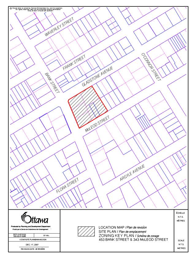
The subject properties are located on the
east side of Bank Street, with frontage on Gladstone Avenue to the north and
McLeod Street to the south as shown in Document 1. The combined
area of the properties is 3761 square metres, with 56 metres of frontage along
Bank Street and a depth of 61 metres.
453 Bank Street contains a three-storey, red brick, flat-roofed building which fronts onto
Bank Street and McLeod Street. The building was constructed and has been used
as a place of worship (Metropolitan Bible Chapel). The remainder of the site comprises of paved surface parking for
the church. The congregation is in the
process of building a new facility and as a result this church has become
surplus to its needs.
343 McLeod Street contains a former detached
dwelling that has been converted and is currently used for commercial purposes
with surface parking located at the rear.
Both properties are designated within the Centretown Heritage
Conservation District requiring that Council approval for any demolition and
new construction be obtained pursuant to the provisions of the Ontario Heritage
Act. Vehicular accesses to the properties are provided from McLeod Street and
Gladstone Avenue.
Bank Street is
designated as a Traditional Mainstreet in the Official Plan. The Centretown
Secondary Plan designates the portion of the site abutting Bank Street as
Residential Office with the remainder of the site designated as Residential
Medium Profile. This area of Bank
Street contains a variety of service commercial, retail, professional and
residential uses in the immediate area
Purpose of
Zoning Amendment
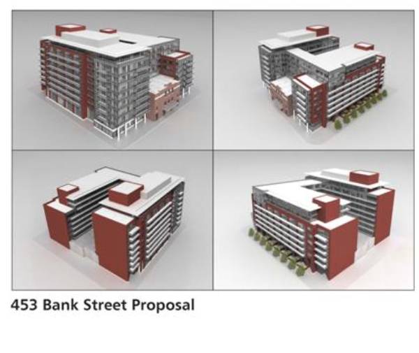
The rezoning application has been submitted to
accommodate the construction of a new commercial, retail and residential
mixed-use building as
shown on Document 4. The height of the building varies along each
frontage to a maximum height of nine storeys along Gladstone Avenue. Commercial, retail and some residential uses
would be located on the ground floor with residential units occupying the upper
floors. 223 dwelling units and 175 underground parking stalls are proposed for the new building with access from
Gladstone Avenue and McLeod Street.
The subject properties currently fall within
two zoning designations. The western
third of the site fronting onto Bank Street from Gladstone Avenue to McLeod
Street is zoned “Neighbourhood Linear Commercial” CN6 F(2.0) H(18.3).
This zone permits a variety of mixed commercial uses that are pedestrian oriented and permits residential dwellings located on upper floors. This zone permits a maximum floor space index (FSI) of 2.0 and a maximum height of 18.3 metres. The rear two-thirds of the site is zoned “Low Rise Apartment” R5D[82] H(10.7). This zone permits medium density residential uses with a maximum height of 10.7 metres. The entire site is also subject to a Heritage Overlay which regulates the permitted height of an existing building notwithstanding the permitted height within the zone. Where there is no building on a site, the underlying zoning regulates the maximum height. Both situations apply to the subject properties as portions of the site are vacant and other areas contain buildings.
The application
proposes a change in zoning to establish a uniform Neighbourhood Linear
Commercial (CN) zoning for the entire site with site-specific modifications to
the maximum permitted height, required yards, parking requirements, loading
areas, landscaping, heritage overlay, bicycle parking and to allow dwelling
units on the ground floor along McLeod Street.
DISCUSSION
Official Plan
Considerations
A. Primary Plan
Strategic Directions
The Strategic Directions Section (Section 2) of
the Official Plan sets broad directions to meet the challenge of managing
growth in Ottawa, providing infrastructure, maintaining environmental integrity
and creating liveable communities. To achieve these, polices are set out
directing major growth towards key locations within the urban area that are
easily accessible and to pursue a mix of land uses and compact forms of
development. This in turn will enable
the City to support a high-quality transit system and make better use of
existing roads and infrastructure.
Within Section 2.2.3, specific strategic directions are set out for
managing growth within the urban area that directs growth to locations with
significant development potential, and especially to areas designated Central
Area, Mixed-Use Centers, Employment Areas, Enterprise Areas, Developing
Communities and Mainstreets. Specific direction is also set out in Section 2.5
for building liveable communities. To
achieve this, great emphasis is placed on community design with attention on
how buildings and the spaces around them look and function in their
setting. The strategic directions set
out in Section 2 are further built on in the policy directions set out in the
Plan dealing with specific land use designations.
Land Use Designation
The subject properties are designated
Traditional Mainstreet. Mainstreets are identified in the Official Plan as
streets that offer some of the most significant opportunities in the city for
intensification through more compact forms of development, a lively mix of uses
and a pedestrian friendly environment.
As such, the plan encourages intensification along Mainstreets through
the redevelopment of vacant lots, parking lots and gas stations as well as
through additions to existing buildings.
Traditional Mainstreets are planned as mixed
use, pedestrian oriented streets. The
Plan encourages redevelopment and infill to optimize the use of land through
increased building height and density. Along
Traditional Mainstreets, heights in the range of four to six storeys are
supported with direction provided for considering greater heights. In this regard, the Plan provides for
considering higher buildings in any one of several situations including where
greater heights have been determined to be appropriate through a Community
Design Plan, where greater heights conform to prevailing heights or provides a
transition between buildings, where increased height contributes to fostering
the creation of a community focus for properties located on a corner or at a
gateway location, where the increased height facilitates the provision of
desired community facilities and services, or where the application of the
provisions of Section 2.5.1 and Section 4.11 dealing with community design and
compatibility determine that additional height is appropriate.
The proposed development to be permitted by the recommended zoning conforms with and implements the key strategic directions set out in the Plan for Mainstreets. The development provides for redevelopment of an underdeveloped property to a level of intensification that will support rejuvenating Bank Street and contribute to an increased population along a key commercial corridor in walking distance to transit, downtown employment and amenities. The development exhibits a design that will integrate into the Bank Street environment through the breaking of the Bank Street façade into architectural segments that respects the variation in building heights in the surrounding area along Bank Street and is of a scale that fits into its urban context. The development will create a new focal point for the community on a corner lot that is currently underutilized and absent of form and beneficial function for the community. The curvature of Bank Street in this area creates a natural reference point which the design of the building will take advantage of architecturally to promote a strong presence and sense of place. The proposed development responds to the specific compatibility considerations of the Official Plan which are elaborated on in the following section.
Compatibility Considerations
To ensure that any new development will
respond to the compatibility objectives of the Plan, direction is provided
under the polices dealing with Mainstreets that any development for which a
rezoning is required to permit intensification be evaluated in terms of scale,
design and compatibility in accordance with the provisions for Compatibility
and Design in Section 2.5.1 and the Compatibility Criteria set out in Section
4.11.
Section 2.5.1
Direction is provided
in Section 2.5.1 as to the meaning of compatible development. In general terms, it provides for compatible
development meaning development that, although not necessarily the same as or
similar to existing buildings nonetheless enhances an established community and
coexists. The development fits well
within its physical context and works well among the functions that surround
it.
Within Section 2.5.1
broad design objectives are set out as qualitative statements of how the City
wants to influence the built environment.
These objectives are broadly stated and are applicable to all land use
designations either at the city-wide level or on a site specific basis.
Design principles are
further set out to describe how the City hopes to achieve the design objectives
with acknowledgment that all the design objectives may not be achieved or
achievable in all cases. Annex 3 to the
Official Plan provides an evocative design framework intended as a catalyst for
the pursuit and consideration of a wide range of planning and design
alternatives that will foster implementation of the design objectives and
principles.
The proposed
development is consistent with and implements the various aspects of the design
objectives and principles as discussed below. The objectives of greatest
significance to the application speak to enhancing the sense of community,
having new development respect the character of existing areas, defining quality
public and private spaces through development and providing for the creation of
adaptable and diverse places.
The first design objective to enhance a sense of community is being achieved by infilling a large vacant site that now breaks the built form and functional continuity of a significant inner urban commercial street and strengthening the urban fabric of the street both physically and functionally. The development also incorporates a key heritage element to retain a relationship of the historical context of the site to the community. Finally, the development will establish a unique focus at a key location along Bank Street and can contribute to the rejuvenation of Bank Street as a key retail street for both the Centertown community and the larger community.
The second
design objective is focused on development complementing the massing pattern,
rhythm, character and context. The Bank
Street elevation respects the existing pattern and rhythm along Bank Street as
the main portion of the former church building will be preserved and integrated
into the new design. The positioning of
the new building is slightly recessed from the portion of the church to be
retained to provide visual prominence for this heritage element while keeping
the new portions of the development as close to Bank Street as possible to
provide for built form continuity. The
variation in the setbacks from Bank Street and building height creates new
vertical and horizontal rhythms to this section of Bank Street which are
compatible with the area. The proposed massing of the building
along the east property line with its blank wall treatment is the one element
of the proposed development that requires modification to better respect the
existing lower profile context as one moves east along Gladstone Avenue and
McLeod Street. This is the subject of specific recommendations in the
accompanying report to obtain required approvals under the Ontario Heritage Act which is referenced in Recommendation 2
of this report.
Encouraging the continuity
of street frontage, meeting the needs of pedestrians and contributing to
attractive public spaces and vistas is the third key design objective. As a result of the retention of the existing
façade and to retain visual prominence for this element of the project, the
newer portions of the building are being setback further while still
maintaining a sense of building continuity that has a strong street
orientation. The increased setbacks
provides some variation that serves to create a larger public amenity area,
space for pedestrian movement and opportunities for additional
landscaping. With respect to meeting
the needs of pedestrians, the introduction of new commercial retail uses at
grade and upper floor residential with ground floor residential along McLeod
will create opportunities for a variety of social and commercial interactions
that previously did not exist. The proposed design will take advantage of the
natural focal point along this segment of Bank Street, specifically created
through the curvature of the road. It is intended that the profile of the
building at the Bank Street and Gladstone Avenue intersection will create a new
landmark for the community and sense of place.
The objective of creating adaptability and
diversity will be implemented through a more compact and diverse building
envelope that efficiently uses land, while contributing to the regeneration of
Bank Street with a new building that integrates the past with contemporary
design. The development proposal will add new commercial, retail and housing
options along Bank Street. The
development will also help reduce resource consumption by promoting residential
intensification inside the urban area along a Transit Priority Corridor and by
providing services to local residents.
Section 4.11
Section 4.11 sets out objective
criteria to evaluate compatibility with respect to more traditional planning
considerations dealing with matters including but not limited to traffic,
parking, building height and massing, pattern of surrounding development, and
micro-climate considerations. The following is an analysis of the applicable
criteria set out in Section 4.11 which demonstrates that the proposed
development is meeting the compatibility tests of the Plan in a way that does
not result in undue adverse impacts.
a) Traffic and Access
A traffic impact study was prepared in support of the application and has been reviewed by staff. Staff concur with the conclusions reached. In this regard, the study determined that the area roads could accommodate the traffic that would be generated without any requirements for roadway modifications and found the proposed private approaches from Gladstone Avenue and McLeod Street to be appropriate. There is no current or proposed access to the site from Bank Street so as to ensure a continuity of built form and retail frontage along this street.
b) Parking
Vehicular parking for the building is provided in accordance with By-law standards, however the application proposed to establish a new minimum parking standard for the building in place of a ratio to allow for a slight reduction in parking required for the commercial use.
The application proposes to provide 175 parking spaces, with 40 parking spaces dedicated to ground floor commercial uses. Under the current by-law parking ratios, 106 parking spaces would be required for the residential component with 53 spaces for the commercial component. As the building is located along a transit corridor and in walking distance to employment areas, staff has no concerns with the new parking standard.
c) Height and Massing
New buildings are to have regard to the area context, massing and height of adjacent buildings. It is recognized that there are no immediate buildings in the area nine storeys in height, however as noted previously, the Official Plan does not require a new building to be the same as other buildings to be considered compatible.
The section of Bank Street where the subject property is located is viewed as an area in transition and reinvestment.
The development is consistent with the direction and vision outlined within the Centretown Secondary Plan and Downtown Ottawa Urban Design Strategy 2020 (DOUDS) (as elaborated on in subsequent discussion) while respecting the main historical portion of the existing church which is to be retained and integrated into the development. The Official Plan states that heights above six storeys may be considered whereas the Centretown Secondary Plan permits heights up to nine storeys. Where variation in height and massing are considered appropriate, transitions in building heights are desirable and can be offset through the use of a more pedestrian friendly at-grade environment. As mentioned previously, the increase in height is considered appropriate given the site’s urban context with no undue adverse impacts anticipated. However, as also noted previously, the eastern façade of the building requires modification to create an appropriate transition to the lower development located to the east of the site.
d) Pattern of the Surrounding Community
To compensate for the proposed variations in building height and mass the building has been designed to appear as three distinct building elements along Bank Street. The Gladstone Avenue and McLeod Street elevations are individual as well, which is representative of the uses found along each section. Along McLeod Street, street oriented townhouse type units are proposed to reinforce and strengthen the residential fabric of this street.
While each building profile varies in height, the design focuses on integrating common building characteristics and materials found in the area along with the retention of a significant portion of the original structure.
e) Loading Areas, Service Areas and Outdoor Storage
The required amount of loading bays will be provided within the proposed building. The application proposes a reduction in the size of the bays to more efficiently meet the expected loading needs for the project.
Staff supports to proposed size modifications which will also allow the loading bays to be fully enclosed so as to reduce impacts on abutting properties and potential congestion on local streets. There is no proposed outdoor storage for the building.
The site falls under two land use designations
within the Centretown Secondary Plan.
The portion of the property that abuts Bank Street for a depth of
approximately 20 metres is designated as Residential Office while the remainder
of the site is designated as Residential Medium Profile. The Centretown Secondary Plan provides goals and objectives
for the entire community that are to be considered in the review of an
application, and specific policies related to the land use designations,
heritage and site development.
The goals of the Centretown Secondary Plan seek
to maintain and enhance the residential character of Centretown while allowing
for a moderate increase in population along with accommodating persons of all
age groups, income levels and lifestyles with good quality and affordable
housing. The objectives of the Secondary Plan provide for encouraging
innovative building and site development to contribute to the physical
environment of the community and enhancing the desirability of Centretown as a
place to live.
The proposed placement of the building in
relation to the curvature of Bank Street creates a natural focal point in the
community when traveling northbound or southbound thereby creating a sense of
place and an attractive vista.
The proposed development is consistent with
objectives focused on protecting and preserving buildings which have local
historical, cultural and architectural significance. The main historically significant portion of the Metropolitan
Bible Chapel is to be preserved and integrated into the design of the new
building. The application will also allow for the revitalization of the local
commercial area by providing commercial facilities and services for nearby
residents on the ground floor of the building. Construction of the new building
will also create an opportunity for additional landscaping to be placed along
all street frontages to improve the pedestrian experience, environment and
overall streetscape.
The Medium Profile Residential Area policies
outline that maximum building heights will be limited. A building height of up to nine storeys may
be considered within this designation with higher buildings only contemplated
where sites are located adjacent to areas designated high profile residential
and where the project provides affordable housing beyond market affordability
as defined in the Official Plan. The
application proposes a maximum height of nine storeys which is the upper height
limit that can be considered for the site under the Centretown Secondary
Plan. The Residential Office
designation states that maximum building heights may be limited but does not
establish a specified height limit.
As previously discussed, the heights proposed
for the building will range from three to nine stories. Given the site’s context, these heights are
considered appropriate. The nine-storey
component of the building will be focused along Gladstone Avenue and extend to
Bank Street to create a focal point along the street.
Along the remainder of Bank Street, the heights
range from the height of the existing church building to six stories reflecting
the typical pattern of heights found along Bank Street and along McLeod Street
the development will provide for a six-storey street edge height with an
additional two stories set back from the street edge façade. This treatment along McLeod Street provides
for an appropriate scale relationship with the built form existing along this
street. To ensure the heights will be
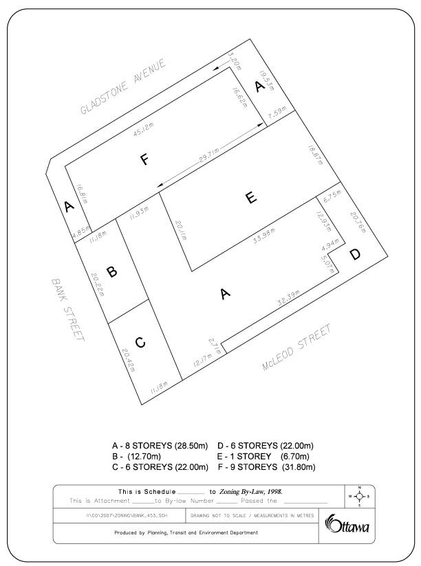
provided as shown on the plans submitted, a height Schedule will be established
in the proposed zoning as shown on Documents 2 and 3.
Site development policies are meant to apply to
vacant sites within Centretown available for redevelopment. A significant portion of the property is
vacant and utilized as surface parking.
Similar to the policies of the Official Plan, the specific residential
site development policies recognize the need to maintain a compact urban form
of development and may adopt regulations relating to yard clearances and
building setbacks which will preserve this form of development. It is the intent of such regulations to
ensure adequate buffering between residential areas and other existing and
possible future land uses. As
recommended by staff, the modification of the eastern façade which faces lower profile
residential buildings is intended to provide for a more appropriate
relationship between the proposed development and existing development to the
east than is currently proposed.
Commercial site development policies direct
that façades of buildings compliment one another and provide a positive
contribution to the overall physical environment of the area.
Parking and loading areas are to be designed to
minimize conflict with adjacent land uses and access points are to be designed
to minimize disruption to traffic flows.
The extension of the building façade along the entire frontage of Bank Street along with
the introduction of new amenity areas and landscaping dramatically improves the
pedestrian experience and the overall physical environment. Parking and loading areas have been designed
to be located internal to the building and access points are located from the
lower order side streets versus Bank Street which is a significant transit
route.
In summary, subject to the modifications to be
made to the east façade, staff considers the proposed development to be fully
in keeping with the applicable policy directions of the Centertown Plan and is
satisfied that the project will make a positive contribution to the community
by strengthening the commercial continuity of Bank Street and providing for
increased residential opportunities for people to live and work in an area
accessible to transit, services, work places and amenities.
Design Review Considerations
The subject property is within the area covered by the DOUDS and subject to design control as per Schedule L – of the Official Plan. Properties within this area require review by the Downtown Ottawa Urban Design Review Panel. The role of the Panel, where a rezoning application is submitted to allow for increased building height and or density, is to assess these changes in the context of the design objectives outlined in DOUDS in order to assist the Department in assessing the application and in bringing forward a recommendation to Committee and Council.
The Panel comments are also intended to inform LACAC of considerations relevant under DOUDS where a proposed development is subject to heritage approval.
A pre-consultation meeting was held with the Design Review Panel in October 2007 followed by a formal submission accompanying the rezoning application. The Panel expressed support for the level of urban intensification proposed, the range of uses and their deployment within the proposed building design. The one concern raised by the Panel related to the eastern façade of the building and its relationship to the eastern property line and lower buildings to the east. The Panel suggested modifications to this facade to provide for an improved contextual fit between the lower profile developments to the east and the proposed building. Subject to this modification, the Panel advised staff that they are prepared to offer full endorsement of the project. Comments from the Design Review Panel are included as Document 6.
Staff concurs with the concern expressed by the Panel and as part of the Departmental recommendations dealing with the accompanying Heritage Act application being considered concurrently with the rezoning, is requiring that modifications to the east facade be made prior to final heritage approval being given. Recommendation 2 contained in this report provides for the by-law to implement the recommended zoning change not being enacted until final heritage approval which will include a modified design for the east facade has been given. A revised façade that could include setbacks and terracing to the east walls would provide for an appropriate and repeatable type of transition between the proposed development and the properties to the east.
Heritage Considerations
The subject properties are located within the Centretown Heritage Conservation District, designated under Part V of the Ontario Heritage Act (OHA). The OHA requires that demolition and new construction in a Heritage Conservation District be approved by City Council. An application for demolition and construction has been submitted as per the OHA and is the subject of an accompanying report to be considered by the Planning and Environment Committee and City Council concurrently with the rezoning
The Official Plan outlines that where a new development is proposed within a heritage area or adjacent to heritage resources, a heritage impact statement must be prepared. A Cultural Heritage Impact Statement was prepared in support of the proposed development. Section 4.6.7 of the Plan requires that new development adjacent to heritage buildings shall respect the massing, profile and character of adjacent heritage buildings. As well, applications should ensure new buildings facing the street approximate the width of heritage buildings and follow established setback patterns of the street. The intent is that new development fit within the established development pattern and that new development integrates well with heritage resources that serve to define the heritage character of the area.
Subject to the modification of
the east façade, as discussed in detail in the accompanying report dealing with
the Heritage Act application, the proposed development is considered to
be in keeping with the intent of the heritage policies of the Official Plan.
Details of Proposed Zoning
Increase in Height
The application proposes an increase in height
of 31.5 meters (nine storeys) for a portion of the building. The remainder of the building is terraced at
various heights when viewed from the Bank Street, Gladstone Avenue and McLeod Street frontages. The increase in height as considered
appropriate with respect to the design objective and principles and the
compatibility criteria of the Official Plan.
The height will be regulated under the recommended zoning through a
height schedule to be included in the Zoning By-law.
Reduced Side Yard
To implement the proposed building footprint,
the application proposes to establish a minimum 1.3-metre side yard abutting
Gladstone Avenue and McLeod Street. The
reduced side yard will still provide an area for landscaping and public amenity
along with the adjacent public right-of-way.
The specific landscaping details will be finalized through the
application for Site Plan Control.
Reduced Rear Yard
For the purposes of administering the new
site-specific by-law and to be consistent with the direction of the new
Comprehensive Zoning By-law,
Bank Street will be considered the frontage of the property.
As a result, the application is proposing a
0.0-metre setback which is consistent with side yard setbacks permitted for
development fronting onto Gladstone Avenue and McLeod Street. It is further noted, while a 0.0-metre rear
yard setback will be permitted, there still remains a requirement for modifications
to the east façade as part of the Ontario
Heritage Act approval being recommend that could result in a setback
being prescribed for all or part of the rear façade.
Minimum Parking Requirements
The property is located along a high volume
transit corridor, is within walking distance to a major employment area, and in
an area with a high amount of pedestrian traffic anticipated. Recognizing these locational attributes, as
previously discussed the application is proposing that a new minimum parking requirement
be established for the proposed development to allow a slight reduction in
required commercial and visitor parking from what would be required when
applying the standard by-law parking ratios.
Reduced Loading Spaces
The application proposes to provide two loading
spaces that are undersized. As previously noted, the Department has no concerns
with the size modifications requested for the loading spaces. The provision for
the required amount of loading will remain the same which is appropriate to
handle the demand.
Required Landscaping Strip
Due to the proposed footprint of the building,
the application does not propose to establish a minimum landscape strip
abutting any street frontage. Detailed
landscaping opportunities will be examined through the related application for
Site Plan Control to better determine the appropriate amount and type of
landscaping for each street frontage.
Currently the entire property is subject to a
heritage overlay that would limit the height of a new building to that which
currently exists. The existing building
is a two- to three-storey building whereas the application proposes a building
of varying heights from three stories for the portion of the main church
building to be retained to six stories along McLeod Street and south of the
main church building with an eight storey element stepped back along these
streets and a nine storey element along Gladstone Avenue and extending to Bank
Street. As a result, the application proposes to remove the heritage overlay
provisions for the subject property and regulate building heights through a
height schedule.
Reduced Bicycle Parking Spaces
The amendment proposes to provide storage
lockers that can accommodate bicycle parking and miscellaneous storage. As such, the rezoning application has
requested modifications to the standards for bicycle parking which would allow
bicycle parking in association with other storage, as well as not providing
bicycle parking in a designated area.
The Department has no concerns with the proposed modifications.
There are no modifications proposed in the
required amount, location or standards for bicycle parking related to the
commercial element of the building.
Residential Units on the Ground Floor
The proposed design incorporates ground level
dwelling units along a portion of the McLeod Street wing. This design element is crucial in
maintaining and enhancing the residential fabric along McLeod Street moving
eastward. To avoid encroachment of
commercial uses along McLeod Street and Gladstone Avenue, standards have been
created in the implementing by-law to limit the visibility of commercial uses
along these streets.
Conclusion
Staff reviewed the project and
requested zoning changes within the context of Official Plan, the Centretown
Secondary Plan and the Downtown Ottawa Urban Design Strategy. With the modification to the east façade
recommended as a condition of the approval for the related Ontario Heritage
Act application, staff are satisfied that the proposed development and
recommended zoning responds to all the relevant planning policies and design
objectives for considering approval.
The proposed amending by-law will create a building envelope that will
effectively implement the proposed recommended design.
ENVIRONMENTAL IMPLICATIONS
A Phase I and Supplemental
Environmental Site Assessment (ESA) were submitted with the application
indicating that there were no significant environmental concerns with the
existing building and site. However, as
a result of a previous use of the site (former fuel outlet) the mandatory
filing of a Record of Site Condition (RSC) will be required as per Ontario
Regulation 153/04. The RSC will be
addressed through conditions of the related application for Site Plan Control.
CONSULTATION
Notice of this application was carried out in accordance with the City's Public Notification and Consultation Policy. The Ward Councillor is aware of this application and the staff recommendation. A summary and discussion of the responses to the public notification is included in Document 6.
FINANCIAL IMPLICATIONS
APPLICATION PROCESS
TIMELINE STATUS
This application was processed by the "On Time
Decision Date" established for the processing of Zoning By-law amendment
applications.
SUPPORTING DOCUMENTATION
Document 1 Location Map
Document 2 Details
of Recommended Zoning
Document 3 Building
Height and Yard Schedule
Document 4 Concept Plan
Document 5 Design Review
Panel Comments
Document
6 Consultation Details
DISPOSITION
City Clerk’s Branch, Council and Committee
Services to notify the owner, David Wex, Urban Capital, 10 King Street East,
Suite 810, Toronto ON, M5C 1C3, Ted Phillips, Taggart Construction 3187 Albion Road South, Ottawa ON, K1V 8Y3, Nat Hughes, FoTenn Consultants
Inc., 232 McLeod Street, Ottawa ON, K2P 0Z8, OttawaScene.com, 174 Colonnade Road, Unit #33, Ottawa, ON K2E 7J5,
Ghislain Lamarche, Program Manager, Assessment, Financial Services Branch (Mail Code: 26-76) of City Council’s decision.
Planning, Transit and the Environment
Department to prepare the implementing by-law, forward to Legal Services Branch
and undertake the statutory notification.
Legal Services Branch to forward the implementing
by-law to City Council.
LOCATION MAP DOCUMENT
1
DETAILS OF RECOMMENDED ZONING DOCUMENT
2
The following change in zoning will be made to all of the lands know municipally as 453 Bank Street and 343 McLeod Street as shown on Document 1.
- The subject lands will be rezoned from CN6 F(2.0) H(18.3) to CN6 [***] Sch [***].
- The subject lands will be rezoned from R5D[82] H(10.7) to CN6 [ ***] Sch [**].
- The following provisions shall apply to lands zoned CN6 [***] Sch [**].
i) The lot line abutting Bank Street shall be considered the front lot line.
ii) Part II, Sections 14 to 19 do not apply (Heritage Overlay).
iii) The minimum front yard setbacks do not apply where they conflict with the requirement of a corner sight triangle.
iv) The minimum Side Yard setbacks abutting a street are:
i. 1 storey (6.7m) - 1.3m
ii. 2 – 8 storeys (12.7m – 28.5m) – 0.0m
iii. 9 storeys (31.8m) – 3.0m
v) The minimum Front Yard setbacks are:
i. 1 – 8 storeys (6.7m – 28.5m) – 0.0 m
ii. 9 storeys (31.8m) – 4.5m
vi) The minimum Rear Yard setbacks are:
i. 1 – 6 storeys (6.7m – 28.5 m) – 0.0m
ii. 7 – 8 storeys abutting McLeod Street – 6.75m
iii. 9 storeys (31.8m) – 7.5m
vii) Despite Part III, Table 50, Visitor Parking – of the minimum parking spaces to be provided, 15 parking spaces shall be for visitor parking.
viii) Despite Part III, Table 51, Commercial Parking – of the minimum parking spaces to be provided, 40 parking spaces shall be provided for all ground floor commercial uses.
ix) Despite Part III, Table 78, Parking – a minimum of 175 parking spaces shall be provided for the entire building.
x) Part III, Sections 87, 88, 90 and 91 do not apply for bicycle parking associated with an apartment building (Bicycle Storage).
xi) Despite Part III, Table 89 Bicycle Parking Rate – bicycle parking for an apartment building shall be provided at 0.70 spaces per dwelling unit.
xii) Despite Part III, Table 108, Loading Space Design
a. minimum width of a loading space shall be 3.0 metres.
b. minimum length shall be 10.0 metres.
xiii) Part III, Section 114 does not apply (Passenger Loading).
xiv) Part IV, Sections 123 and 124 do not apply (Landscaped Area).
xv) Ground floor commercial uses may occupy a maximum length of 39.0 metres of the frontage on Gladstone Avenue measured from Bank Street.
xvi) Ground floor commercial uses may occupy a maximum length of 24.0 metres of the frontage on McLeod Street measured from Bank Street.
xvii) Despite Part VII, subsection 295 (2) dwelling units are permitted on the ground floor along McLeod Street,
xviii) Part VII, Table 298 does not apply (CN Zone regulations).
xix) That the maximum permitted building heights are as shown on Document 3 (New Schedule).
BUILDING
HEIGHT SCHEDULE DOCUMENT
3
CONCEPT ELEVATIONS DOCUMENT
4
DESIGN REVIEW PANEL COMMENTS DOCUMENT 5
The design review panel submits the following report for 453 Bank Street/343 McLeod Street based on a pre-consultation meeting held in Ottawa and on the package submitted for formal review in December 2007. The panel notes this site was identified as a re-development opportunity in the Downtown Ottawa Urban Design Strategy.
The panel appreciates the level of completeness in the design brief as prepared by FoTenn Planning and Urban Design. This package has assisted greatly in the review.
The panel would like to express support for level of intensification, the overall program of uses and their deployment within the project on this site.
The panel specifically references;
·
The modulation of the
building massing and types along Bank Street and feels that the project will
add positively to Bank Street in this location.
·
The retail ground floor
will animate the street and help to re-establish this area as a retail service
zone.
·
The grade related
housing and streetscape on McLeod is a very positive feature.
During the pre-consultation the panel expressed concern with the eastern end of the building and the relationship to the property line and the context of the houses to the east. The panel suggested that the building should not be 100 per cent to the property line and not be composed of six‑storey and eight-storey blank walls. Suggestions included introducing terracing and setbacks to the east walls and that they be fully developed architecturally recognizing that the eastern walls will be very visible to the adjacent houses and the general context of the neighbourhood including the park at the Museum of Nature.
There is a specific reference to this in the DOUDS on page 61
“Regardless of the
height of new buildings, the City should carefully review all design aspects
including street setbacks, architectural quality, contextual fir, massing,
parking provisions and the distance between buildings. It is important to note that while zoning
may define allowable building envelopes, design review could impose limitations
and require further refinements within that envelop to ensure compatibility with
local conditions. As building heights
exceed 6 storeys this design review becomes even more critical to ensure
appropriate development and compatibility with the existing context.”
To be specific;
1. The façade and massing is still presenting a blank unarticulated wall between six stories and eight stories tall at the eastern property line. The panel does not feel this massing at the property line is a good repeatable urban design for the intensification of Bank Street.
2.
The panel had asked that the adjacent buildings be drawn on the elevations and the three‑dimensional
computer model to illustrate how this transition was to be successful. This has
not been done.
3.
Elevations are required for all four facades. The east façade is still
missing.
4.
The panel discussed a change in massing to lower and or set back the end
module (east end between grid 10 and 11) to reduce the height of this wall at
the property line. No attempt to address this has been made. The building as designed is too tall at the
eastern end and the blank brick walls in a single plane are not an appropriate
repeatable condition. Please see DOUDS, pg 61.
5.
The building between the towers has also been moved to the property line
and expressed in a blank wall which appears to be concrete at the property
line. This is not an acceptable edge condition between the properties.
6.
Lane - explain how this area will operate. This feature should include
overhead doors to close this opening from the street, complete the facades at
the street line and reduce impact on the adjacent properties to the east.
Recommendation
The design review panel would recommend these changes be made before granting the project approval.
CONSULTATION
DETAILS DOCUMENT
6
NOTIFICATION AND CONSULTATION PROCESS
Notification and public consultation was undertaken in accordance with the Public
Notification and Public Consultation Policy approved by City Council for Zoning
By-law amendments.
PUBLIC COMMENTS
Five letters were received from members of the public. Two letters were submitted in opposition to the application and three were in support.
Comments in opposition raised concerns related to adequate parking for the building and the impact of the east façade of the building on abutting properties.
Response
With respect to parking the building is proposing two levels of underground parking that conform to the by-law requirements. The application has not requested a reduction in parking. With respect to the east façade of the building, staff share the same concern and as a result have recommend the redesign of the building to create a better transition to the lower profile buildings.
Comments in support of the application were supportive of residential intensification along this section or Bank Street, the introduction of a building that can improve the profile of the area and the possibility of this development attracting additional investment in the area.
COUNCILLOR’S COMMENTS
General
Comments:
Redevelopment of this
site should transform a pivotal intersection in Centretown by introducing a
desirable residential intensification to an empty tract of Bank Street. The
overall components of the project - a strong continuous retail presence on
Bank, with mid-rise housing units above meet the goals of the 'Traditional Mainstreet'
zoning and the Centretown Plan's Medium-Profile residential OP designation. .
Increase
in Maximum Building Height:
Although the
requested increase in maximum height from six storeys to nine is at the
upper limit of what is acceptable within a medium-profile residential and the
Bank Street zoning, and there are other sites where a nine storey height would
not be appropriate, it has to be assessed in the site-specific context of the
property, which is on a busy arterial roadway across from an automotive use. I
note that the McLeod Street frontage has been stepped down to six floors, with
ground-oriented townhouses at grade that are more appropriate to the McLeod
Street block.
The re-zoning should
be a built-form envelope that conforms to this proposal and adheres to the
various stepped down transitional sections.
Compatibility
with Centretown Heritage Conservation District/Heritage Overlay Provisions:
The Centretown HCD
guidelines state that each application for new construction in the district should be
assessed for its compatibility with its environs, streetscape, footprint and
massing. It does not require new buildings to be copies of other historic
buildings in the area - but clearly buildings of their time. In this case, the
immediately adjacent streetscape is very mixed, and would not be overwhelmed by
the new building. Its massing (a U-shaped block) respects and echoes a
well-established footprint seen in other mid-rise apartment buildings in the
Centretown area, and the mixed use (with commercial at grade, and residential
above) is seen up and down Bank Street in earlier examples.
Given the
above rationale, I am in support of this application.
ADDITIONAL COMMENTS FROM THE COUNCILLOR
In response to the Application for new construction in the Centretown Heritage District, Councillor Holmes submitted these additional comments:
The 'rear' of the
building is a remains an unresolved design issue. The blank
masonry walls of each wing and the concrete base of parking podium need to be
articulated to reduce their impact. This was the primary comment of the Urban
Design Peer Review Panel, and I share their concerns.
While the proposed
building is certainly an uncompromisingly contemporary design statement, its
functional programme (at-grade storefronts and residential units above) is
a traditional format that is already found on commercial streets in the
Centretown Heritage District. This is further echoed by the proposed U-shaped
apartment block (another historic form) - so in that sense it meets the spirit
of the design management guidelines for the Centretown HCD. The use of red
brick continues a material that predominates the Centretown area. The portion
of the Bible Church that is to be entirely demolished does not have
architectural significant.
From the preservation
perspective, it would have been desirable to retain the 1930s portion
of the tabernacle in its entirety. On this site, with no existing heritage
streetscape in its blockface, or immediately abutting it, I feel that the Bank,
Gladstone, and McLeod facades of the new building are generally appropriate -
although certainly at the upper limit of what would be acceptable in
terms of height in this zone. That said, the street level treatment of the
commercial space along Bank Street should be more pedestrian friendly, finely
detailed, and make a positive contribution to the Bank Street retail ambience.
The treatment of the
east side of the building is not acceptable. I cannot support a building
having blank walls and a concrete base. The wall needs to be stepped down and
articulated to be more sympathetic to the area to the east.
COMMUNITY ORGANIZATION COMMENTS
Centretown Citizens’ Community Association (CCCA)
At a meeting on November 20, 2007 the developer made a presentation regarding the proposal. A motion was passed which states that the CCCA does not support any building on this site higher than the current zoning permits. The CCCA is not opposed to development in Centretown; however it should be appropriate to the area and must respect existing zoning by‑laws.
While height was a key issue in the discussion,
other comments related to inappropriate building materials, unsuccessful
integration of the façade of the church, no appreciable landscaping and lack of
parking.