|
1. TMP Update: Downtown Transit
Solution and Rapid Transit Network – Recommendations Mise à
jour sur le Plan directeur des transports : Solution pour le transport
en commun au centre-ville et réseau de transport en commun rapide dans le
centre-ville – Recommandations |
joint CommitteeS’ recommendations as amended
That Council approve
the following:
1. That staff review the option of an
LRT terminus more central to the Riverside South community as part of the
staging process and report back to Committee and Council in the fall.
2. That staff
recommended Option 4 be amended to extend Light Rail Transit (LRT) in the east
to Trim Road (along Cumberland Transitway) and in the west to Scotiabank Place
subject to the following:
·
Development of transit corridors inside Greenbelt
first
·
Business case supports return on rail investment
(ridership, capital and operating costs)
·
Achieving a minimum density target (to be
determined in the updated Official Plan)
·
Availability of funding
3. That
Council direct staff to include all proposed streetcar corridors as detailed by
the international review panel be referred to the TMP update.
4. That the
following Motion be referred to the proposed Joint Consultative Committee - STO and City of
Ottawa Transit Committee:
That
Committee and Council direct staff to utilize as an option for service
integration with Gatineau (STO) in the recommended staff option for the
Transportation Master Plan be for integrated rail via existing bridge links.
5. That the
following Motion be referred to the Environmental Assessment Study for this
transit project for the Ottawa River Parkway:
That
Committee and Council direct staff to develop a local implementation strategy
for the electrification of the Transitway (that includes route and mitigation
measures) in consultation with the local ward councillor and community.
6. That
Council direct staff to consider all rail corridors as detailed in the Mayor’s
Task Force on Transportation and report back to Committee.
7. That all
identified rail corridors be protected until the Transportation Master Plan is
approved.
8. That
staff:
·
Undertake an intensive evaluation of
existing bus routes to improve operating practices and service standards
·
Improve traffic congestion by
improved road engineering and cycling network development.
9. That the recommended
Transit Network be approved on the following basis:
a) A city-wide network that ultimately
extends LRT to Kanata, Orléans and Barrhaven/Riverside South;
b) A priority network within the
planning horizon based on Option 4, as amended.
Recommandations modifiées dES ComitÉS conjoints
Que le Conseil approuve ce qui suit:
1. Que le personnel examine l’option
d’un terminus du TLR plus central pour la collectivité de Riverside-Sud dans le
cadre du processus d’ordonnancement des travaux et qu’il en fasse rapport au
Comité et au Conseil à l’automne.
2. Qu’on
modifie l’option 4 recommandée par le personnel pour prolonger le train
léger sur rail (TLR) dans le secteur est jusqu’au chemin Trim (le long du Transitway
de Cumberland) et dans le secteur ouest jusqu’à la Place Banque Scotia, sous
réserve des facteurs suivants :
·
Que
des couloirs de transport en commun soient d’abord aménagés à l’intérieur de la
ceinture de verdure
·
Qu’une
analyse de rentabilisation démontre un rendement de l’investissement dans le
système sur rail (achalandage, coûts d’immobilisations et d’exploitation)
·
Qu’une
cible de densité minimale soit atteinte (à déterminer dans le Plan officiel mis
à jour)
·
Que
des fonds soient disponibles
3. Que
le Conseil donne au personnel la directive d’intégrer tous les couloirs de
tramway proposés par le comité d’examen international à la mise à jour du PDT.
4. Que
la motion suivante soit renvoyée au comité consultatif mixte proposé – STO
et Comité du transport en commun de la Ville d’Ottawa :
Que le Comité et le Conseil donnent au personnel la directive d’utiliser
comme option d’intégration du service avec Gatineau (STO) dans l’option
recommandée par le personnel pour le Plan directeur des transports le système
sur rail intégré utilisant les ponts existants.
5. Que
la motion suivante soit renvoyée à l’étude d’évaluation environnementale de ce
projet de transport en commun pour la promenade de l’Outaouais :
Que le Comité et le Conseil donnent au personnel la directive d’élaborer
une stratégie de mise en œuvre locale de l’électrification du Transitway (qui
comprend le parcours et les mesures d’atténuation) en consultation avec le
conseiller du quartier local et les membres de la collectivité.
6. Que
le Conseil donne au personnel la directive d’examiner tous les couloirs
ferroviaires proposés par le Groupe de travail du maire sur les transports et
d’en faire rapport au Comité.
7. Que
tous les couloirs ferroviaires indiqués soient protégés jusqu’à ce que le Plan
directeur des transports soit approuvé.
8. Que le personnel :
·
entreprenne
une évaluation intensive des circuits d’autobus existants pour améliorer les
pratiques d’exploitation et les normes de service;
·
réduise
la congestion en améliorant la technique routière et le réseau cyclable.
9. Que le Réseau de transport en commun recommandé soit
approuvé selon les modalités suivantes :
a) un
réseau municipal qui prévoit le prolongement du TLR jusqu’à Kanata, à Orléans
et à Barrhaven/Riverside-Sud;
b) un
réseau prioritaire dans l’horizon de planification qui est fondé sur la version
modifiée de l’option 4.
Documentation
1.
Deputy City Manager, Planning, Transit and the
Environment report
dated
15 April 2008, (ACS2008-PTA-PLA-0016).
2. Extract of draft Joint Minutes 6, 21
May 2008, may be distributed prior to Council.
Report to/Rapport au :
Joint Transportation and Transit Committee
Réunion conjointe du Comité des Transports et du Comité du Transport en
Commun
15 April 2008 / le 15avril 2008
Submitted by/Soumis par : Nancy Schepers, Deputy City Manager/Directrice
municipale adjointe,
Planning, Transit and the
Environment/Urbanisme, Transport en commun et Environnement
Contact Person/Personne ressource : Vivi Chi, Manager/Gestionaire
Planning
Branch/Direction de l'urbanisme
(613)
580-2424 x21877, vivi.chi@Ottawa.ca
REPORT RECOMMENDATIONS
1.
That this report be
received and tabled for public consultation and future consideration by the
Joint Transportation and Transit Committee meeting on May 21, 2008; and
2.
That, subject to
public consultations, the following recommendation be tabled at the May 21,
2008 meeting of the Joint Transportation and Transit Committee:
That the Joint Transportation and Transit
recommends that City Council approve Option 4 as the preferred downtown transit
solution and future rapid transit network.
RECOMMANDATIONS DU RAPPORT
1.
Que
le présent rapport soit soumis et déposé aux fins des consultations publiques
et de son examen futur à la réunion du Comité conjoint du transport et du
transport en commun le 21 mai 2008;
2.
Que,
sous réserve des consultations publiques, la recommandation suivante soit
déposée à la réunion du Comité conjoint du transport et du transport en commun
le 21 mai 2008 :
Que le Comité conjoint du transport
et du transport en commun recommande au Conseil d’approuver l’option 4 comme
solution privilégiée en ce qui a trait au transport en commun au centre-ville
et au réseau de transport en commun futur.
EXECUTIVE SUMMARY
Assumptions
and Analysis
This report presents the primary rapid transit network component of the Transportation Master Plan (TMP) update for Committee’s and Council’s consideration and approval. The phasing or implementation plan (including possible interim solutions, and development of secondary transit corridors) will be assessed over the coming months and will be subject of another round of public consultation and reporting to Committee and Council in Fall 2008.
The review of the rapid transit system began in the Fall 2007, starting with a series of high-profile public consultation events on the transportation vision with particular emphasis on transit. The proposed Transportation Vision and a summary of the consultation are attached as Documents 1 and 2. Key transit comments received include:
· Support for a public transit system that is convenient and reliable;
· Transfers are acceptable provided that service is frequent and waiting areas are pleasant;
· Strong support for a downtown transit tunnel;
· Continuing interest in caring for the environment;
· Need to develop a transit plan that is affordable.
Following the visioning exercise, surface, elevated and tunnel connections through the downtown were assessed and only the tunnel option was deemed to be feasible. Four network options, all with a tunnel facility, were developed with combinations of bus and/or rail based transit systems. Agencies, business groups, and the public were extensively consulted on the four network options.
A strong majority of those who participated in the consultation events prefer the rapid transit network Option 4 (Figure 7). This network has a light rail transit (LRT)-based tunnel with rail transit in an east-west direction between Baseline and Blair transitway Stations. The network also includes a north-south rail line from downtown to Bowesville, including a link to the Airport. Extensions to all suburban nodes from the rail terminus points will continue to be on the Transitway.
The recommended rapid transit network Option 4 represents the minimum light rail and bus-based system that is required to serve the City to the year 2031, with an anticipated population of 1.136 million by that time. Its most significant feature that sets this plan apart from previous plans is the LRT tunnel through the downtown and the conversion of the Transitway to LRT between Baseline and Blair Stations. This grade separation will ensure reliable transit service through the downtown, which will encourage transit ridership and result in the City meeting its transit modal split target of 30 per cent. The transit tunnel could also be a major catalyst for partnerships with the private sector to create a vibrant community with services connected to active transit stations below ground. The network is also flexible in that it does not preclude future extensions of the LRT to the suburbs should it be deemed financially prudent to do so. In the meantime, BRT corridors to the suburbs can continue to be built so that early rapid transit service can be brought to these communities. The consultant’s technical report on the network development is attached as Document 3.
Options have also been left open to integrate with the Société de transport de l'Outaouais (STO) bus-based transit services. STO integration will be addressed through the City’s upcoming Downtown Transit Tunnel Planning and Environmental Assessment Study and the Interprovincial Transit Integration Strategic Planning Study (the latter to be led by the National Capital Commission (NCC) with joint partnership of the City of Ottawa and STO/Gatineau).
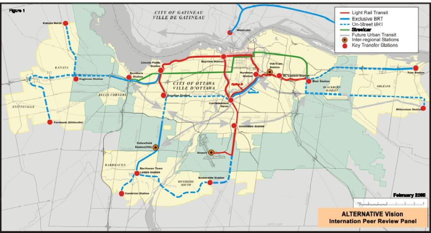
Staff also engaged an international team of respected transit and urban planning professionals to conduct a technical review of the proposed primary rapid transit network. The Peer Review Panel’s report and a brief background description of the panel members is attached as Document 4. Key findings of the Panel include:
· 30 per cent modal split target is achievable;
· Option 4 is recommended, however LRT corridors should be limited to inside the Greenbelt area (with BRT connections to the designated outlying Town Centres);
· LRT connection to the Airport is recommended because Ottawa is the nation’s capital;
· Transit investment should be contained within the current urban boundary and that only basic mobility (e.g. Para Transpo) be provided beyond;
· Aggressive management of land use and growth is required to complement the massive transit investment program that is envisaged for Ottawa;
· STO should continue to operate on-street in downtown Ottawa if possible.
Next steps in the TMP update relating to transit planning include examining the secondary corridors (grey lines depicted in Figures 4,5,6, and 7) and developing an implementation/priority plan. In setting the priority plan, the following factors need to be considered for each of the projects/corridors in the transit network:
· Ridership;
· Status of planning work to date;
· Ease of implementation (minimize disruption, opportunities to integrate with development, etc.);
· Logical sequencing of projects to maximize transit benefits;
· Opportunities to implement interim solutions/staging;
· Affordability (funding, available cash flow).
Financial Implications:
The preliminary cost estimate for the primary transit corridors in Option 4 (in 2008 dollars) is approximately $4B and the annual operating cost in year 2031 would be approximately $434M. The costs are subject to detailed planning and environmental assessments and system configuration. Secondary transit corridors still need to be developed and costs estimated. Estimated cost does not include costs for STO solutions, inflation, property acquisition or additional costs for unforeseen circumstances.
The current Long Range Financial Plan includes a total funding envelop of approximately $2.1B for rapid transit over the 10 years of the plan. This forecasted budget includes the anticipated minimum 1/3 contribution each from the Federal and Provincial governments. Discussions are continuing with the funding agencies.
Public Consultation/Input:
The consultation program to-date has consisted of two main phases:
Phase 1 took place throughout September to December 2007 and focussed on informing and seeking feedback from citizens about various transportation related challenges and opportunities facing Ottawa. Within this context, the TMP Vision and Guiding Principles were reviewed and key information was collected with respect to the development of a preferred rapid transit network. Document 2 further summarizes the consultation process and outcomes from Phase 1.
Phase II consultations began March 3 and concluded March 31, 2008 as an exercise to inform and seek feedback from the public about four Downtown Rapid Transit Network Options and their implications on the overall transportation systems. A number of activities were undertaken including open houses, discussion groups, stakeholder focus group sessions, online consultation and a Mayor’s streeter survey. Feedback received is summarized in Chapter 8 of Document 3.
BACKGROUND
During the 1970s, the former Region began a program to implement a
rapid transit system. This program led to the construction of the initial
31-kilometre Transitway network (the sections from Baseline Station in the
southwest to Blair Station in the east and South Keys Station in the
southeast). Since the completion of
these initial sections, several extensions and use of freeway shoulder lanes
have been planned, parts of which have been implemented. To complement the Transitway system, an
eight-kilometre diesel light rail service, commonly known as the O-Train, was
introduced in 2001 between Greenboro and Bayview Stations. Today, the City has 46 kilometres of
rapid transit system (in exclusive rights-of-way and shoulder lanes), which has
been a key factor in Ottawa attaining enviable transit ridership levels. Ridership has reached over more than 120
riders per capita – highest in North America of comparable-size cities.
This success, however,
has led to the system reaching its capacity in the downtown area and has
contributed to congestion problem and reliability issues especially in the
winter months. The lack of transit
capacity in the downtown area has been a topic of discussion for many
years. Previous studies have identified
the eventual need for a grade separated rapid transit facility through the
downtown. Regional/City Council decided
to continue with further extensions of the bus Transitway outside of the
Central Area first, leaving the expensive grade separation of the downtown
section until later. This “outside-in” approach to Transitway development
helped with the early establishment of Ottawa’s high transit ridership.
The 2003 Rapid Transit
Expansion Study (RTES) identified the implementation of a light rail transit
(LRT) service from the downtown (Rideau Centre) to Riverside South (Limebank
Station) as the top priority project. RTES reviewed the concept of a downtown
transit tunnel and concluded that the proposed on-street LRT corridor, combined
with operational improvements along the Albert and Slater Street Transitway,
would provide the required transit capacity within the 2021 planning period.
The plan to proceed
with the North-South LRT was approved by Council in November 2005 with a
condition of reducing the number of buses operating on Albert and Slater
Streets by 30 per cent. This
condition would have resulted in consolidating and reducing the number of
direct-to-downtown express routes.
However, in December 2006, due to non-fulfillment of conditions, the Project Agreement for the N-S LRT Project was terminated in accordance with its terms. One of the principle reasons leading to the decision not to proceed with the contract award for the North-South Corridor LRT project was concern over the proposed mixed operation of the LRT with buses and general traffic on Albert and Slater Streets.
In January 2007, Mayor O’Brien formed a Task Force to study the City’s transportation priorities. In June 2007, the Mayor’s Task Force delivered a report entitled “Moving Ottawa”. The report covered a wide range of transportation issues, but focused on the development of a future rapid transit plan. The Task Force recommended an east-west rail tunnel bored through the downtown with diesel-electric trains operating on a city-wide network that would switch to electric mode while in the tunnel.
In
November 2007, Council approved the scope of work for the Downtown Ottawa
Transit Tunnel Planning and Environmental Assessment Study. Furthermore,
Council identified the completion of the Transitway, construction of the
downtown tunnel, implementation of rapid transit using the Cumberland
Transitway corridor and the implementation of the LRT to the south-eastern
growth area as the City’s priority projects for transit funding.
The update of the Transportation Master Plan (TMP), which is being undertaken in conjunction with the five-year review of the Official Plan, provides an opportunity to reassess the City’s growing transit need to 2031, also keeping in mind the City’s vision for a transit system beyond the planning horizon.
This report summarizes the
technical work leading to the proposed network and technology options, public
feedback received as well as the recommended option for the downtown and its
implications on the rest of the network.
The analysis and recommendation presented in this report are one component of a
larger study to update the TMP.
DISCUSSION
Transportation Vision and Guiding
Principles
Throughout the Fall of 2007, the TMP Vision and Guiding Principles were reviewed through the following new and unique public consultation activities:
· Educational materials ‘White Papers’;
· Online Consultation (Beyond Ottawa 20/20, Ottawa Talks, etc.);
· Streeter Surveys;
· Stakeholder-based Focus Groups;
· The City Café event;
· A Transportation Master Plan Interactive Workshop.
What We Heard
· Overall, a significant majority of people felt that the existing TMP Vision and Guiding Principles continues to remain valid and that only modest changes should be considered with respect to: the natural environment; performance measurements; implementation timelines; affordability; and land use planning.
· People want a transit system that is efficient, convenient, reliable and comfortable.
· Interest in the idea of a downtown transit tunnel is strong. Many people believe that a tunnel is needed immediately while others believe further study is required to examine potential alternatives.
· A strong majority of people believe the City should consolidate express routes and expand feeder-line-haul service to improve transit speed and reliability through the downtown provided that transfers are convenient, quick, reliable and comfortable.
This led to the development of the following revised TMP Vision Statement (in box below) and its accompanying Guiding Principles, as summarized in Document 1.
|
Transportation Vision In
2031, Ottawa’s transportation system will enhance our quality of life by
supporting social, environmental and economic sustainability in an
accountable and responsive manner. |
Feedback from this phase of consultation influenced the development of the downtown rapid transit options as presented later in this report. Document 2 provides a complete summary of public comments received.
Development of the Downtown Rapid Transit
Network
Planning Assumptions (population,
employment)
Projections of Ottawa’s long-term growth are fundamental to the City’s assessment of future infrastructure needs. As part of the Official Plan review, the City’s current 2021growth projections were comprehensively re-examined for the new 2031-planning horizon. The development of these new growth projections considered the Greater Ottawa-Gatineau Area (including adjacent municipalities) to ensure that the magnitude and the extent of the commuter shed were included in the overall assessment of growth for Ottawa.
The City’s population is projected to grow by approximately 30 per cent to reach 1,135,700 by 2031 (an additional 265,000 persons). Employment is expected to grow by approximately 35 per cent to reach 703,000 (an additional 180,300 jobs). The 2031 population and employment levels for major growth areas, and the percentage increase over current population and employment levels are summarized in Figure 1. By 2031, approximately 52 per cent of the population and 72 per cent of employment will be located in areas inside the Greenbelt.
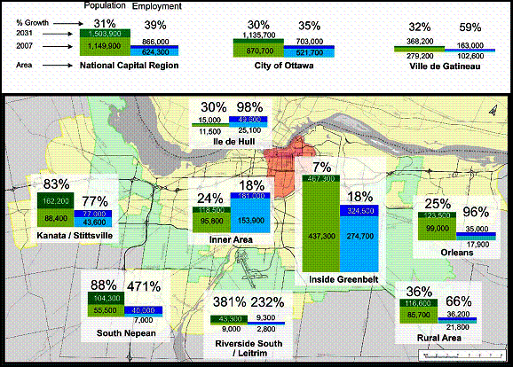
Figure 1.
2031 Population and Employment Projection by Major Growth Area
Future Travel Demand
The requirements for transportation systems is fundamentally linked to where people live and work, with the most significant demands occurring during peak commuter travel times. Therefore, the travel demand analysis efforts have been focused on the morning peak hour as it represents the time of the day when road networks experience increased levels of congestion and is the busiest hour for transit use.
The 2031 morning peak hour travel demand forecast was determined using a computer-based long-range transportation demand model (TRANS model). The model was recently redeveloped to incorporate the state-of-the art modeling practices and calibrated against the 2005 Origin-Destination Survey.
Main findings of the forecast modeling, as summarized in Table 1, include:
1. Total travel by all modes will increase by about 38 per cent during the morning peak hour.
2. Non-motorized trips (walking and cycling): City-wide, morning-peak hour trips is forecast to grow by about 50 per cent, from 23,700 to 35,400 trips.
3. City-wide growth in trips by automobile during the morning peak hour is forecasted to increase by approximately 24 per cent (from 146,600 to 182,300 trips) which is less than the rate of population growth. The growth in auto vehicle use is largely to destinations outside the Greenbelt. City-wide morning peak hour mode split will decrease from 77 per cent to 70 per cent.
4. City-wide growth in travel by public transit during the morning peak hour is forecasted to increase by approximately 76 per cent (from 44,500 to 78,300 trips). City-wide transit mode split is forecast to increase from 23 per cent to 30 per cent by 2031.
5. Transit mode split, for morning peak hour, is forecasted to increase from 46 per cent to 55 per cent for trips destined to the Inner Area, from 26 per cent to 36 per cent for trips destined to inside the Greenbelt and from 9 per cent to 19 per cent for trips destined to outside the Greenbelt
6. Transit mode split is forecasted to increase from 24 per cent to 29 per cent for trips originated from outside the Greenbelt.
Table 1. Growth in Travel by all Modes of Travel (Morning Peak Hour)1
|
Ottawa Travel2 AM Peak Hour |
2006 |
2031 |
Percentage Growth |
||||
|
Person Trips |
Mode Share3 |
Mode Split4 |
Person Trips |
Mode Share |
Mode Split |
||
|
Walking/Cycling
(Non-Motorized) |
23,700 |
11% |
- |
35,400 |
12% |
- |
49% |
|
Transit Riders |
44,500 |
21% |
23% |
78,300 |
26% |
30% |
76% |
|
Private Auto Trips |
146,600 |
68% |
77% |
182,300 |
62% |
70% |
24% |
|
Total - All Trips |
214,800 |
100% |
100% |
296,000 |
100% |
100% |
38% |
1.
Individual
area transit mode split values are summarized in Appendix D of Supporting
Document 3
2.
Includes
all travel originating or destine to Ottawa
3.
Mode
share is the percentage of trips made by one mode, relative to total trips made
by all modes
4.
Mode
split is the percentage of trips made by one mode, relative to total trips made
by motorized modes
Primary Travel Desire Lines:
Figure 2 shows the 2031 predicted primary travel flows (i.e. greater than 1,700 trips/hour) as well as the transit mode split between different planning areas. The width of the arrows indicates the magnitude of travel (number of morning peak hour person trips) and the colour of the arrow indicates the transit mode split (the darker the colour, the higher the transit mode split).
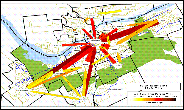
Figure 2. Primary
Desire Lines (2031 morning peak hour)
As demonstrated in Figure 2, during the morning peak hour, Ottawa’s Inner Area will continue to be the most significant destination for travel since more than one-quarter of Ottawa’s 2031 employment base will be located inside the Inner Area. However, as a result of the significant planned growth in the urban areas outside the Greenbelt, other strong travel demand between other areas of the city will emerge, such as: from Orleans to AltaVista area; from Kanata to Bayshore and Merivale areas; and from Barrhaven to Merivale, Bayshore and Kanata areas.
Urban areas located outside the Greenbelt will continue to be attracted to transit to reach Ottawa’s Inner Area with average mode splits reaching 70 per cent (i.e. during the morning peak hour, 70 per cent of trips from the suburban areas to the Inner Area will be by transit). Transit mode splits for the other primary travel demand between other urban areas are predicated to be in the mid 20 per cent to 30 per cent range.
Downtown Transit Ridership
The configuration of the rapid transit network will dictate the corridor that transit customers will take and the directions through which they enter downtown. Riverside South/Leitrim residents as well as some Barrhaven residents could be carried north on the current O-Train corridor through Carleton University and Bayview Stations and enter the downtown from the west. The other option would be for Riverside South/Leitrim residents to use the current Southeast Transitway corridor to enter the downtown from the east. Each of these options would have different ridership implications on the capacity requirements for the downtown. The downtown transit demand for these two options is shown in Figure 3. The peak passenger demand would range between 13,700 and 15,600 passengers per hour. Option to fully integrate transit customers from Gatineau could potentially add up to 8,500 passengers per hour.
To visualize the scale of the problem in the downtown core, up to 347 standard buses at 10 seconds apart or 223 articulated buses at 16 seconds apart would be required to carry the 15,600 potential transit riders per hour entering downtown using Ottawa transit system. In addition, 252 standard buses or 162 articulated buses would be required to carry future morning peak hour transit customers coming from the City of Gatineau.
It is clear that the downtown will continue to be the bottleneck of the system and addressing the downtown transit congestion will need to be a priority if the City were to achieve the 30 per cent transit mode split target. The following section describes the different options that were investigated to provide the required capacity to accommodate future transit demand in the downtown area.
|
2006 Transit Demand |
2031 Transit Demand |
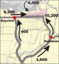
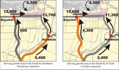
Figure 3.
Existing and Future Transit Demand in the Downtown Area (morning peak hour)
Alternatives
for serving the downtown
Various options to provide the necessary
transit capacity to accommodate anticipated transit demand in the downtown were
assessed:
· Surface options
· Elevated option
· Tunnel options
Surface Options
The theoretical capacities of the bus-only lanes on Albert and Slater Streets are 195 buses per hour per direction. In the last five years, in responding to severe delays to service in the downtown, transit service has been modified to reduce the number of buses from over 200 to no more than 180 buses per hour to maintain service reliability. However, with the current operating strategy and with transit ridership continuing to grow, it will be impossible to accommodate the growth in ridership without exceeding the physical capacity of the two streets.
The following measures to increase the potential capacity of the downtown Transitway are examined:
· Consolidating express routes;
· Use of additional bus-only lanes on each of Albert and Slater Streets;
· Dedicating Mackenzie King Bridge for transit only;
· Use of other downtown streets such as Wellington Street, Queen Street and Laurier Avenue;
· Increasing the use of high-capacity buses such as double-deck or double-articulated vehicles.
Each of the above measures would have unfavourable traffic impacts and would create a negative on-street environment that would be unattractive to pedestrians and cyclists, and unacceptable to the adjacent business and property owners. Adding more buses on the streets would jeopardize the reliability of the transit operation especially during winter months. In addition, the analysis shows that even combining all of the above measures does not offer the required capacity to accommodate 2031 ridership demand.
Light-Rail Transit (LRT) surface option was also examined. It is estimated that a two-car LRT vehicle, operating every one minute, would be required to carry future transit demand. This frequency is much higher than the 2.0- to 2.5-minute minimum practical frequency for rail operation. Using longer trains will not be possible because the required platform length will necessitate the closure of adjacent property access points. Therefore, the LRT-only surface option is not an acceptable downtown transit solution for the long term.
Two concepts of a combined bus and LRT operation were examined during the North-South Corridor LRT project EA Study: one direction of LRT and BRT on each of Albert and Slater Streets; and two directions of LRT service on one street and two directions of BRT service on the other street. The two-direction concept was deemed to be unsafe. The one-direction concept of LRT and BRT on separate lanes was rejected as it would have significant impact on business due to the loss of the left-hand curb lane used for parking, loading, delivery and taxi zones. The one-direction concept of LRT and BRT on the same lane was deemed feasible and would be sufficient to carry the anticipated demand (20 two-car LRT and 180 buses on each street during peak hour). This was an appropriate solution at that time given that the funding envelop for the North-South LRT project was limited. The EA noted that a grade separation should not be precluded, as it would be required at some point in the future to ensure reliability of service. Due to concerns related to the reliability of the combined LRT/BRT operation, Council directed staff to reduce the number of buses by a minimum of 30 per cent by 2009 and evaluate the possibility of removing up to 100 per cent of buses. In order to remove large volumes of buses, more bus-to-bus transfers will need to be introduced. This reduced and modified service, however, would not accommodate the transit demand being forecasted for the 2031-planning horizon.
Based on the above, it is clear that there is no feasible surface-only transit solution in the downtown area without severely impacting adjacent businesses, having an undesirable urban environment and severely impacting the reliability of transit service.
Elevated Option
An elevated option for downtown was considered in the 1988 “Central Area Transitway Grade Separation Feasibility Study”. The Study found that an elevated solution would create a visual barrier through downtown, reduce direct sunlight to street level and would have very high capital costs to integrate stations into existing adjacent buildings. Also, the elevated solution would require significant utility relocation, and would have high operating and life-cycle costs due to exposure to the elements. For the above reasons, the elevated solution was not recommended.
Tunnel Options
A tunnel can resolve many of the current surface operating problems, as it would allow unconstrained flow through the downtown and hence improve the reliability of transit service. It will also provide weather-protected amenities for transit customers, improve pedestrian and cycling operations, reduce street noise and emissions, and present opportunities to enhance the street environment. A range of transit technologies that may be incorporated in the tunnel was considered. They include bus-only, LRT-only, and combination of bus and LRT. These different options are discussed in more details in the next section.
Combined surface/tunnel options were also
considered. There are two main
options: Bus-only tunnel with LRT on
the street; or LRT tunnel with buses operate on the surface. However, since both options will require
extensive financial investment in building the tunnel component and since the
tunnel can provide the necessary capacity to fully accommodate future demand,
there is no need to continue surface operation for anything more than local
routes for the ultimate network. This
would maximize the use of the tunnel and will improve the return on the
investment.
Primary Rapid Transit Corridors – Network
Options with Tunnels
The approach that is taken is to build a network from the core out — addressing downtown congestion and determining the best way to serve communities in the west, south and east. Therefore, four alternative core rapid transit networks, each incorporating a tunnel option, have been developed to determine the most appropriate long-range rapid transit network and technology to serve Ottawa. These options are:
· Network Option 1: BRT Tunnel - Bus based
· Network Option 2: BRT/LRT Tunnel – Bus based with North-South LRT
· Network Option 3: LRT Tunnel - East and West downtown LRT
· Network Option 4: LRT Tunnel - East and West downtown LRT plus North-South LRT
The four options are illustrated in Figures 4, 5, 6 and 7 with existing corridors shown as solid lines and future extension as dashed lines. The broad grey arrows represent other possible complementary rapid transit corridors, which will be evaluated following Council’s decision on the primary transit network.
All options will require the move
to a feeder-line-haul operation with major transfer points to be at Baseline,
Lincoln Fields, Hurdman and Blair Stations.
The basic difference between each of the above options is the extent to
which LRT is incorporated. The
following sections describe briefly each of the four options.
Option 1: BRT Tunnel - Bus
based
This option is based on the existing bus Transitway with extensions to outlying suburban areas in the east, west and south. It incorporates an underground bus tunnel through the downtown and keeps the existing diesel-powered O-Train service from Bayview Station to Greenboro Station.
To address emission concerns in the tunnel, low emission buses such as hybrid-electric buses are assumed to be used on the main feeder-line haul. Also, to simplify passengers boarding in the downtown area, consolidating of some express buses will be required which will result in more transfers from bus to bus for some residents. An articulated bus running every 18 seconds through the downtown tunnel is required to accommodate the projected 2031 peak hour transit ridership demand.
Option 2: BRT/LRT Tunnel – Bus
based with North-South LRT
This option is based on the existing bus Transitway with extensions to outlying suburban areas in the east, west and south and the addition of a twin-track electric North-South LRT line from Bowesville Station to the downtown and the University of Ottawa with a connection to the airport. A joint-use LRT/bus tunnel through the downtown is incorporated to accommodate both the east-west buses and the North-South LRT trains. Similar to Option 1, consolidation of some express services and the introduction of low-emission buses on the main feeder-line haul will be required. A combination of two-car LRT trains running every 3 minutes and 45 seconds, and articulated buses running every 22 seconds through the downtown tunnel is required to accommodate the projected 2031 ridership demand.
The LRT is extended beyond the
Greenbelt to Bowesville to reach the preferred location for a rail maintenance
yard, which was approved as part of the North-South Corridor LRT EA Study. The existing Walkley yard has several
operational issues dealing with its size and access, additional cost and
environmental liability that prohibit its use for the North-South LRT
corridor. An advantage of the extension
is to serve the Riverside/Leitrim communities as they are currently not served
by any form of rapid transit service.
Option 3: LRT Tunnel - East
and West downtown LRT
This option is based on an LRT-only tunnel through the downtown, which requires a conversion of the Transitway between Baseline Station and Blair Station to twin-track electric LRT. It also includes Transitway extensions to outlying suburban areas in the east, west and south. The existing diesel O-Train would continue in operation as it does today from Bayview Station to Greenboro Station. Train sets of four-cars each need to run every 2 minutes and 18 seconds through the downtown tunnel to accommodate the projected 2031 transit ridership demand.
Bus to LRT transfers will mainly occur at Baseline, Lincoln Fields, Hurdman and Blair Stations. Baseline Station directly serves Algonquin College and is the focal point for the development of the Nepean Centrepointe lands as well as provides a direct connection to the Southwest Transitway. Lincoln Fields Station provides a direct connection to the West Transitway, as well as to transit routes operating on Carling Avenue. Hurdman Station is already a major transfer facility, located at the connection of the East and Southeast Transitways. Blair Station is at the convergence point of the East and Cumberland Transitways, and is surrounded by employment and retail developments.
It should be noted that for Option 3, the Southeast Transitway is extended to provide direct service to Riverside South residents destined to downtown. For this reason, Option 3 is not a staging option for Option 4.
Option 4: LRT Tunnel - East and
West downtown LRT plus North-South LRT
This option is essentially the same as Option 3 except that the O-Train is converted to twin-track electric LRT and extended to Bowesville Station with an LRT connection to the airport. Riverside South residents would travel to the downtown on the North-South LRT line. This option will require four-car LRT trains running every two minutes and four seconds through the downtown tunnel to accommodate the projected 2031 transit ridership demand.
Bus to rail transfers will occur at Baseline, Lincoln Fields, Bowesville,
Hurdman and Blair Stations. Further LRT extensions east, west and southwest are
possible and can be considered, but the segments from Baseline to Blair
Stations and from Bayview Station to Bowseville Station have been selected as
the minimal segments required for a successful operation. .
Figure 4.
Network Option 1: BRT Tunnel - Bus based
Figure
5. Network Option 2: BRT/LRT Tunnel –
Bus based with North-South LRT
Figure 6.
Network Option 3: LRT Tunnel - East and West downtown LRT
Figure 7. Network Option 4: LRT Tunnel - East and West downtown LRT plus North- South LRT
Capital and Operating Costs for Different
Network Options – Primary Transit Corridors
Preliminary capital cost
estimates for each of the four options are provided in Table 2, in 2008 dollars.
These estimates include engineering and contingency costs, but make no
allowance for property costs. Details
are included in Appendix G of Supporting Document
3. They are subject to refinement through further detailed planning work
and environmental assessments, as appropriate.
Table 2. Capital and Operating
Costs for Different Network Options (millions $)
|
Section |
Description |
Alternative 1 |
Alternative 2 |
Alternative 3 |
Alternative 4 |
|
|
Central Downtown |
Bayview
to Hurdman (excluding
Tunnel) |
$49 |
$68 |
$112 |
$112 |
|
|
Downtown Tunnel |
$780 |
$1032 |
$555 |
$555 |
||
|
West Downtown |
Baseline
to Bayview |
$22 |
$22 |
$237 |
$237 |
|
|
East Downtown |
Blair
to Hurdman |
0 |
0 |
$97 |
$97 |
|
|
South Downtown |
Bayview
to Bowesville Includes
Airport Link |
$100 |
$435 |
$100 |
$435 |
|
|
South Transitway |
Barrhaven
Town Centre to Bowesville |
$100 |
$100 |
$100 |
$100 |
|
|
West Transitway |
From
Southwest Transitway to Kanata |
$338 |
$338 |
$338 |
$338 |
|
|
Southwest Transitway |
Cambrian
to Baseline |
$180 |
$180 |
$180 |
$180 |
|
|
Southeast Transitway |
Greenboro
to Hurdman Includes
Hospital Link |
$44 |
$44 |
$44 |
$44 |
|
|
East Transitways |
Blair
to Trim and Blair
to Millennium |
$239 |
$239 |
$239 |
$239 |
|
|
LRT Maintenance Facility |
|
|
$100 |
$100 |
$200 |
|
|
Bus Maintenance Facility |
|
$300 |
$240 |
$120 |
$120 |
|
|
Infrastructure Sub-Total |
$ 2,152 |
$ 2,798 |
$ 2,222 |
$ 2,657 |
||
|
LRT Vehicles |
0 |
$140 |
$750 |
$890 |
||
|
BRT Vehicles* |
Initial Fleet |
$800 |
$720 |
$400 |
$320 |
|
|
Replacement Vehicles |
$600 |
$540 |
$200 |
$160 |
||
|
Vehicles Sub-Total |
$1,400 |
$1,400 |
$1,350 |
$1,370 |
||
|
|
$3,552 |
$4,198 |
$3,572 |
$4,027 |
||
|
|
$ 485 |
$ 472 |
$ 453 |
$ 434 |
||
Note 1: Cost estimates are
subject to verification through EA studies and system design
Note 2: Estimates do not include costs for STO solutions, inflation, property acquisition and additional cost for unforeseen circumstances
Note 3: Vehicle costs are
estimated over 30 years
Note 4: Operating costs are to accommodate the demand at the end of the planning horizon (2031)
Opportunities for STO Service Integration
La Société de transport de l’Outaouais (STO) currently operates
approximately 120 buses serving 4,400 peak hour transit passengers through
Ottawa’s central core
on the Rideau/Wellington Street
corridor. The combined operation of STO
interprovincial and OC Transpo transit on the Rideau/Wellington corridor is
currently nearing capacity with little room for growth.
This interprovincial ridership demand is expected to increase to 8,500
peak hour passengers by 2031, which translates to approximately 250 standard
buses in the peak hour. STO currently
uses mostly standard buses to service their interprovincial passengers. STO has plans for a future BRT operation in
a freight rail corridor in Gatineau and does not anticipate any need to convert
to rail transit service within the planning horizon.
Four very preliminary options were developed to show how interprovincial
STO service might be integrated in downtown Ottawa with the primary rapid
transit network options described above.
Option A: Surface Transit - STO would continue to operate on the
surface in downtown Ottawa. However, with a projected 250 buses per hour in the
peak direction, a single corridor will not provide enough capacity. Therefore,
STO buses would require more streets in Ottawa’s downtown on which to
operate. This is not an acceptable
option and solutions have to be developed.
Option B: Shared Transit Tunnel – STO buses cannot be accommodated in the
bus tunnels proposed for rapid transit network Options 1 and 2 because of the
limited bus tunnel capacity. For network Options 3 and 4, a wider LRT/BRT
tunnel would be required to accommodate STO buses with an estimated additional
construction cost of $475M.
Option C: Separate Transit Tunnel - a separate bus tunnel for STO services
could be built with an estimated additional construction costs of $610M.
Option D: Transfer to Ottawa LRT – for rapid transit network Options 2, 3 and 4, there is capacity in the tunnel to accommodate additional STO passengers if they transferred to the Ottawa LRT system. Additional trains would be needed to accommodate the extra STO passengers. Transfer point could be located either in Ottawa or in Gatineau. Estimated additional construction cost could range between $35M for a transfer point in Ottawa to $190M for a transfer point in Gatineau.
A more detailed analysis will be undertaken to select the preferred
option for interprovincial rapid transit service through the upcoming joint
NCC/Ottawa/Gatineau-STO Interprovincial Rapid Transit Strategic Integration
Study, and the Downtown Transit Tunnel Planning and EA Study.
Evaluation of Options
The four rapid transit network options are assessed using a common set of evaluation criteria. These criteria are grouped under four general categories: Transportation; Natural Environment; Social/Cultural Environment; and Costs.
Transportation:
· Transit ridership attraction
· Accommodating forecast transit ridership by 2031
· Accommodating transit growth beyond the planning horizon
· Operating issues that may impact service reliability
Natural Environment
· Air quality and greenhouse gas emissions
· Biophysical environment (amount of salt use during winter operation)
Social / Cultural Environment
· Urban form (intensification and redevelopment opportunities)
· Access to key destinations
· Tourism and national capital image
· Noise and vibration
Costs
· Capital construction costs
· Vehicle costs (including replacement)
· Operating Costs
The results of
the relative evaluation of the four network options are presented in Table 3
Table
3. Evaluation Summary of the Different Network Options
|
|
Alternative 1 Bus Based |
Alternative 2 Bus with NS LRT |
Alternative 3 EW LRT |
Alternative 4 EW and NS LRT |
|
|
Transit and
Transportation |
|||||
|
Transit Ridership Attraction |
Base ridership of 76,400
trips (Growth of 31,900) Limited potential |
Ridership of 76,900 trips (Growth of 32,400) (2% more than Alternative
1) Some potential |
Ridership of 78,700 trips (Growth of 34,200) (7% more than Alternative
1) Greater potential |
Ridership of 79,200 trips (Growth of 34,700) (9% more than Alterative 1) Greatest potential |
|
|
Accommodating Forecast Transit Ridership |
Theoretically could operate at capacity Requires stations with; ·
4 bus bays ·
Fare pre-payment ·
Bus platoons |
Buses may be accommodated but will operate close to
theoretical capacity NS LRT vehicles can easily be accommodated Mix of bus and LRT traffic is unbalanced |
LRT vehicles can be accommodated |
LRT vehicles can be accommodated |
|
|
Accommodating Transit Growth Beyond the Planning Horizon |
No flexibility to accommodate growth beyond the
planning period |
Minimal room for additional buses LRT component has additional capacity but it is not
required for this option |
Has room for growth. Longer trains and more frequent service could be provided |
Has room for growth. Longer trains and more frequent service could be provided |
|
|
Operating Issues |
Operating at capacity will mean that the service
reliability is substantially reduced Small delays will cascade
through the system causing larger delays well after the first delay is
cleared |
Buses will be operating close to capacity, which may
alleviate some of the reliability issues however the loss of the passing lane
will affect service Allowing buses to use the LRT lane will require reduced operating speed, affecting capacity |
Signalized system will operate well |
Signalized system will operate well |
|
Natural
Environment
|
|||||
|
Air Quality and GHG emissions |
682,900 kg CO 63,900 kg HC 515,500 kg NOx 33,300 kg SOx 11,800 kg PM 88,875 t CO2 |
646,900 kg CO 60,400 kg HC 489,400 kg NOx 31,600 kg SOx 11,100 kg PM 84,227 t CO2 |
557,300 kg CO 52,200 kg HC 421,700 kg NOx 27,200 kg SOx 9,600 kg PM 72,559 t CO2 |
512,000 kg CO 47,800 kg HC 387,300 kg NOx 25,000 SOx 8,800 kg PM 88,875 t CO2 |
|
|
Excavated Material |
Tunnels: 390,000 cu. m. Stations: 3 standard
stations |
Tunnels: 390,000 cu. m. Stations: 3 larger stations
(to accommodate extra platforms) |
Tunnels: 140,000 cu. m. Stations: 3 standard
stations |
Tunnels: 140,000 cu. m. Stations: 3 standard
stations |
|
|
Salt Use |
Highest use |
Second highest use |
Second lowest use |
Lowest use |
|
|
Social / Cultural
Environment |
|
|
|
|
|
|
Property and Development Criteria |
Continuation with the current technology will
encourage similar property and development patterns |
Introduction of some LRT will encourage more
development in those areas |
Substantial LRT network will encourage a substantial
amount of property and development interest |
Largest LRT network with the greatest potential to
encourage property and development interest |
|
|
Capital Image |
No improvement to Capital
Image |
Improves Capital Image
somewhat |
Fosters very good Capital
Image |
Fosters best Capital Image |
|
|
Public Support |
No support |
No support |
Some support |
Substantial support |
|
|
Direct Airport Service |
Provides bus access to the
Airport |
Provides rail access to the
Airport |
Provides bus access to the
Airport |
Provides rail access to the
Airport |
|
|
Noise and Vibration |
Largest proportion of the
network is bus-based Highest impact |
Less bus-based activity
than Alternative 1, however busiest routes remain bus-based Second highest impact |
Similar to Alternative 4,
but with more bus-based service in the south Second lowest impact |
Smallest proportion of the
network is bus-based Lowest impact |
|
|
Costs |
|
|
|
|
|
|
Capital Construction Costs |
$ 2,152 M |
$ 2,798 M |
$ 2,222 M |
$ 2,657 M |
|
|
Vehicle Costs (including replacement) |
$1,400 M |
$1,400 M |
$1,350 M |
$1,370 M |
|
|
Total Capital Costs |
$3,552 M |
$4,198 M |
$3,572 M |
$4,027 M |
|
|
Operating Costs |
$485 M |
$472 M |
$453 M |
$434 M |
|
Public and Agency Consultation
Consultations began March 3 and concluded March 31, 2008 as an exercise to inform and seek comments from the public on the four Downtown Rapid Transit Network Options and their implications on the overall transportation system. A number of activities were undertaken to provide flexible and convenient opportunities for the public and agencies to provide comments to the City, as listed below:
· Open Houses held at various locations throughout the City, including a public presentation at City Hall followed by a questions and answers period;
· Registered Discussion Groups as part of each Open House;
· Stakeholder Focus Group Sessions;
· City Advisory Committee Briefings
· Online Consultations;
· Internal and External Agency Group Meetings;
· Mayor’s Streeter Survey.
In
total, approximately 1200 written submissions were received during the month of
March, which shows the great interest in this planning exercise.
What
We Heard
A
summary of the consultation effort and feedback is attached in Chapter 8 of Document
3.
In general, a strong majority of the public and stakeholders indicated Option 4 as the preferred long-term transit solution for Ottawa (approximately 70 per cent of all comments received supported Option 4). The respondents believe that Option 4 provides the highest quality of transit service; is the best approach for urban intensification; has the lowest operating costs; has optimum long-term transit growth capacity; has the most positive environmental, social and economic impacts; and projects the most favourable perception of Ottawa as the Nation’s Capital City.
While there was also support for Option 3 (approximately 22 per cent of all comments received) many suggested that this alternative could serve as a ‘staged’ implementation for ultimately developing Option 4. It should be noted, however, that Option 3 would only be a staging of Option 4 if the existing O-Train were to be extended further south to connect Riverside South to downtown, otherwise the direct route to downtown for these residents would be the extension of the Southeast Transitway as depicted in Option 3.
There was little to no support for Option 1 and Option 2 (approximately three per cent of all comments received). People found these options to be the least sustainable and economically viable networks for the future.
Few people were either undecided or did not prefer any of the four options (approximately 5 per cent of all comments received). Additional key issues included:
Extension of LRT Service
Many people suggested that the LRT corridors shown in Option 4 should extend further to serve urban communities beyond the Greenbelt such as Kanata, Barrhaven and Orleans. Several people also suggested a northern LRT extension to the City of Gatineau.
Response:
The options presented illustrate the recommended minimum LRT service
requirements and do not preclude future additional LRT service extensions. Adding more LRT service will increase
capital costs. For the projected
transit demand volumes to 2031, it is not necessary to extend the LRT lines
beyond what is depicted in Option 4.
Corridor Locations
Some people mentioned that existing rail lines should be utilized. Others suggested that providing LRT corridors inside the Greenbelt would result in less suburban sprawl and greater urban intensification. Some people questioned the feasibility of the corridors identified in Option 4 such as using the Ottawa River Parkway.
Response: In general, most of Ottawa’s existing rail lines are not located close to where many people live or work and would be more appropriate for a regional commuter system than for urban transit. The options do not preclude the development of a commuter system using existing rail lines in the future. All corridors identified in the options, including the use of the Ottawa River Parkway, are subject to Environmental Assessments and functional designs.
Interprovincial Integration
Several people suggested a need for greater transit integration between the City of Ottawa and the City of Gatineau. Ideas ranged from developing a single interprovincial system to more integration between the two transit networks. Both the Ontario Ministry of Transportation (MTO) and the Ontario Ministry of Public Infrastructure Renewal (PIR) recommended greater coordination between the Interprovincial River Crossing Environmental Assessment, STO’s Rapibus System Plan, and the National Capital Commission Transit Study.
Response: City of Ottawa, City of Gatineau, STO, MTO, MTQ and the NCC are frequently involved in joint transportation planning studies. This coordination is on going. Staff appreciates the importance of a coordinated effort while also respecting the autonomy between our different cities.
Urban Design
Many people commented that they want an attractive and well-designed transit system with comfortable and accessible transit stations that are well integrated with development. Personal security and safety are also concerns. The idea of consolidating express routes and expanding feeder-line-haul service is acceptable if transfers are convenient, quick, reliable and comfortable (enclosed heated shelters).
Response: Station features and integration will be addressed during the design stage of each approved project. The City of Ottawa Urban Design Guideline and the Transit-Oriented Development Guidelines provide very good direction for urban design. The City’s Transit Service Policies identify standards for quick and reliable service.
Environmental and Human Health Impacts
Many people stated that Option 4 would have the most positive environmental and human health impacts. Greenhouse gas emissions were a major concern for many people from both a natural environment and human health perspective. People suggested that a transit tunnel that is well integrated with adjacent developments would improve the downtown environment, particularly during the winter months.
Response: Opportunities to integrate with development will continue to be
investigated through out all planning phases of each project.
Social, Mobility and
Accessibility Impacts
Several people noted mobility and accessibility concerns associated with new transit stations and a downtown transit tunnel. Other people commented that improvements to our transit system are a priority as a way to improve mobility for people that do not drive (i.e. aging population, students, etc) and that transit improvements, particularly an LRT system, would help to improve Ottawa’s perception as a great world-class national capital city.
Response:
Mobility and accessibility will continue to be major considerations in the
planning and design phases of each project.
All transit stations will be wheelchair accessible and will include
elevators, as provincially mandated.
Economic
and Financial Implications
Many people mentioned that they support Option 4 because it has
the lowest operational costs and the greatest potential for land value uplift
and attracting new development. Several
people suggested that additional funding is required from senior levels of
government. Some people, including the
Ontario Ministry of Transportation (MTO) and the Ontario Ministry of Public
Infrastructure Renewal (PIR), recommend a more detailed analysis of the costs
and benefits. Both MTO and PIR also
recommend additional short-term transit investments to address immediate
transit challenges. People stated that operational costs are an important
consideration as operational costs are mainly funded locally through fares and
taxes. Increasing future fuel costs
associated with a bus-based system was also a noted concern.
Response:
Costs (capital and operating) will be refined as each project advances
forward from strategic planning to detailed planning (and environmental
assessments), design, and implementation phases. Cost-benefit analyses for each project will be undertaken as this
is typically a condition of funding from senior levels of government.
Technology Choice
Most people said they prefer electric LRT technology rather than hybrid electric-diesel or hydrogen, as it is perceived as a more sustainable, non-fossil fuel approach. A few people suggested that a subway or an elevated monorail system should be considered.
Response:
Environmental impacts associated with various technologies are part of the
evaluation criteria for assessing the different network options. An elevated solution was not recommended due
to the major aesthetic and physical impacts as detailed in the Document 3 and
the RMOC Central Area Transitway Grade-Separation Feasibility Study (1988). An LRT system provides sufficient capacity
for the projected transit demand volumes to year 2031 and also provides more
service flexibility than a subway.
Construction and Phasing Implementation
People commented about disruptions to transit service during the construction period and are concerned about reduced transit ridership while the transit infrastructure is being built. Some people questioned the need to twin the tunnel under Dows Lake and the impacts on ridership this would have during the construction period.
Response:
There will always be disruption to transit service and general traffic
whenever major transportation projects are constructed. A comprehensive plan will be developed to
mitigate as much of the negative effects as possible. This work will be undertaken closer to the timing of project
implementation.
Ridership
Several people suggested that ridership should be the primary criterion for evaluating the four transit options, including the implementation-phasing plan of the preferred option. People mentioned that Option 4 would lead to the highest ridership due to its reliability and attractiveness.
Response: Ridership is a key evaluation criterion in assessing the various network options.
Peer Review
The City of Ottawa engaged a Peer Review Panel of respected professionals with decades of transit and urban planning experience to carry out the technical review of the proposed primary rapid transit network.
The Panel examined the transit network in place today and that proposed by the TMP study team in terms of their effectiveness in serving Ottawa’s existing and future travel demand. The Panel assessed the reasonableness of the study’s assumptions, methodologies, findings and conclusions pertaining to corridor locations, technology and estimated cost including the proposed downtown transit options.
The Panel’s report is included as Document 4. Key comments/recommendations made by the Panel with respect to the primary rapid transit network include:
· The 30 per cent peak hour modal split target appears achievable in light of current 23 per cent transit mode split;
· Bus Rapid Transit (BRT) alone will not provide the all-day mobility and urban development that are needed for future success;
· Light Rail Transit (LRT) corridors should be limited to inside the Greenbelt area with Bus Rapid Transit connections to the designated outlying Town Centres;
· Significant concerns about reliability of transit surface operation as well as the visual and mobility barrier presented by transit vehicles and passenger volumes making downtown public environment less attractive;
· LRT should operate in a tunnel through downtown with a two-corridor LRT system that includes an east-west line from Blair Station to Baseline Station, and a north-south line from Bayview to the Ottawa International Airport;
· Rapid transit corridors should be fully segregated to the greatest extent possible (providing good travel time and reliability);
· The existing O-Train corridor should be converted to a double-track LRT, with the line extended south only to the airport;
· STO buses should operate on-street in downtown Ottawa if possible into the future;
· No Transitway development beyond the Kanata, Barrhaven, and Orleans Town Centres;
· Transit investment should be contained within the current urban boundary and that only basic mobility (e.g. Para Transpo) should be provided beyond;
· Commuter rail network in the Ottawa region and beyond is not justified through 2031;
· Ottawa’s Greenbelt is a major asset and it should always be a permanent defining feature of the City as Canada’s Capital;
· The projection of 80 per cent of population growth and 58 per cent of employment growth to 2031 to occur outside the Greenbelt is a major concern – should focus population growth inside the Greenbelt to achieve a more efficient transit system;
· Aggressive land use and growth pattern are required to complement the massive transit investment program that is envisaged for Ottawa.
RECOMMENDATION
Recommended Rapid Transit Network Option
Based on the technical evaluation of the different core network options and feedback from the public as well as advice from the Peer Review Panel, it is recommended that Option 4 be selected as the preferred long-term core rapid transit network option. While the long term capital cost of this option is the most expensive, it provides a number of major benefits to the City including:
· The lowest annual operating costs;
· The highest annual ridership;
· The lowest negative impact on the environment as a result of the lowest greenhouse gas emissions and the least amount of winter salt contamination;
· The best overall quality of rapid transit service over the entire city;
· The best overall image of the city as a world capital including a direct and attractive rail connection from the airport to downtown and the parliament precinct for visiting tourists and world delegations; and
· The highest quality of transit service to key city destinations.
This recommendation is consistent with the Peer Review Panel recommendations with respect to the primary rapid transit work. The only exception is that the Peer Review is recommending terminating the North-South LRT at the airport with no further extension to Riverside South. Staff recommendation is to extend the line to Bowesville to connect to the preferred location for a rail maintenance facility.
NEXT STEPS
The TMP Update will continue with further transit planning matters upon Council’s approval of the primary rapid transit network. These next activities include developing:
Secondary Transit Corridors
These are shown as grey links on the various network options. They are intended to link the primary corridors, enhance transit service coverage, and provide flexibility and choice for transit users. Potential secondary corridors to be examined are Carling, Rideau/Montreal, Baseline, Hospital, OCR rail and VIA rail corridors. Results of the analysis will be subject to public review in early Fall 2008.
Implementation Plan:
Following the approval of the primary rapid transit network in May 2008 and the identification of the secondary corridors, a priority implementation plan to year 2031 will be developed in order to move forward with the transit implementation program in a staged approach. Developing the implementation plan will consider the following:
· Ridership (corridor demand, easing downtown transit congestion, enhance level of service for existing riders and attracting new riders);
· Status of the planning work;
· Difficulty of construction, potential complexity of design, uncertainty of location;
· Logical sequencing – e.g. need to connect to a maintenance facility;
· Staging flexibility (possible interim solutions);
· Minimize service disruption during construction;
· Support smart growth objectives of intensification and redevelopment.
Tunnel Planning and EA Study:
This study will be undertaken concurrently with the TMP. The consultant selection process is underway. It is expected that the study will start in late Spring. The Study will be undertaken in accordance with the new accelerated Environmental Assessment Process for Public Transit Projects (expected to be in place by June 2008). With the likelihood of requirements for federal permits and property, and with the City pursuing federal funding, the Study will also have to comply with the requirements of the Canadian Environmental Assessment Act (CEAA). The Study will be using the technical work completed to date for the TMP which confirmed an LRT tunnel as the preferred solution.
Land Use and Transportation Demand Management
Policies
As the City develops its rapid transit network, a commitment to complementary land use and Transportation Demand Management (TDM) policies will be made, including:
· Identify density targets for areas adjacent to rapid transit stations, especially at mixed-use centers;
· Ensure that type of development at rapid transit stations is transit supportive;
· Increase the overall accessibility of the rapid transit station;
· Revisiting the Zoning By-law to ensure that intensification targets can be met and “up” zone if necessary to facilitate intensification;
· TDM measures to change behaviour and promote transit as a more sustainable mode of travel;
· Fare policy to help spread transit peak demand to minimize capital and operating costs.
Other TMP Update Tasks:
· Assess road infrastructure needs
· Assess other modes (cycling, pedestrian) and their infrastructure requirements
· Identify budgetary needs for infrastructure and programs for all modes
· Identify project priorities for all modes
· Develop implementation plan
· Update TMP policies
· Consult with public and agencies in late September/early October
· Prepare draft TMP for tabling in November 2008 to coincide with the tabling of the draft Official Plan
CONSULTATION
The TMP consultation objectives have been to engage, in a meaningful way, a broad range of citizens and stakeholders in a dialogue around Ottawa’s long-term transportation planning.
Towards this effort, the consultation program has consisted of two main phases, as summarized in Document 2 and in Chapter 8 of Document 3.
Phase 1
Phase 1 took place throughout September to December 2007 and focussed on informing citizens in new and unique ways about various transportation related challenges and opportunities facing Ottawa. Within this context, the TMP Vision and Guiding Principles were reviewed and key information was collected with respect to the development of a preferred rapid transit network. Document 2 further summarizes the consultation process and outcomes from Phase 1.
Phase II consultations began March 3 and concluded March 31, 2008 as an exercise to inform the public about the four Downtown Rapid Transit Network Options and their implications on the overall transportation systems. A number of activities were undertaken to provide flexible and convenient opportunities for the public and agencies to provide comments to the City, as summarized below and further outlined in Chapter 8 of Document 3.
· Four Open Houses held at various locations throughout the City;
· Registered Discussion Groups as part of each Open House;
· Stakeholder Focus Group Sessions;
· City Advisory Committee Briefings;
· Online Materials and Consultations;
· Internal and External Agency Group Meetings;
· Mayor’s Streeter Survey.
Open
Houses
Four Public Open Houses were held during the first week of March in various locations across the city. In total, approximately 400 individuals attended the Open Houses and 156 comment sheets were completed and submitted at the events.
Registered
Discussion Groups
Registered Discussion Groups were conducted between 7:00 and 8:00 p.m. at each of the Public Open Houses. In total, 152 people participated in the discussion groups. The format involved up to eight participants seated at each table and supplied with information and maps of the four Downtown Rapid Transit Networks. Technical facilitators led the discussions at each table and all comments and input was collected on flips charts.
Stakeholder
Focus Group Sessions
Three Stakeholder Focus Group Sessions were held at City Hall during the first week of March 2008. Participants were organized into an Industry, Economic or Downtown group according to their various interests and areas of expertise. Each session included a presentation of the four transit options followed by an open discussion.
City
Advisory Committee Briefings
A number of the City of Ottawa Advisory Committees with an interest in transit and transportation were invited to participate in a briefing on the Downtown Rapid Transit Network Options. Several Advisory Committee members also participated in the Public Open Houses and Registered Discussion Groups.
Online
Materials and Consultations
The Beyond Ottawa 20/20 website (www.ottawa.ca/beyondottawa2020) has been extensively used to promote the TMP update process, including all Public Open House materials, online feedback forms and additional background information. All information has been provided in both official languages. In total, 631 written submissions were received in the month of March via the online comment form, fax, mail and email.
Internal
and External Agency Group Meetings
The City hosted two meetings with various agencies during the first week of March 2008 that included representatives from different levels of governments, crown corporations and private interest groups. The primary objective of the agency meetings was to provide information about the four Downtown Rapid Transit Network Options. Each meeting included a presentation and was followed by an open discussion.
Mayor’s
Streeter Survey
A Streeter Survey was conducted with the Mayor during the week of March 17, 2008 to provide a brief snapshot of the public's awareness and opinions of the City's long-term transit plans. The locations were selected to capture a diverse set of opinions, mostly from transit users. The survey team approached people at transit stops, bus stops, park and ride lots, and sidewalks and asked a series of brief questions. In total, 401 surveys were completed.
Further Consultation
Following the tabling of the recommended rapid transit network on 16 April 2008, further consultation will be undertaken to seek public feedback on the recommendation. Events include:
· Six city-wide ward consultations between April 21 and May 6, inclusive
· Online interactive consultations through OttawaTalks
· Online Feedback Form
Inputs received though these consultation events will be presented to Joint Transportation and Transit Committee on May 21.
FINANCIAL IMPLICATIONS
The capital cost estimates included in the report are preliminary and will be subject to detailed planning and EA work. The costs do not include the secondary transit corridors – still to be developed and costed. It does not include costs for STO solutions, inflation, property acquisition and additional cost for unforeseen circumstances.
For the purpose of estimating the capital and operating costs for transit vehicles, LRT vehicles and standard propulsion buses are assumed. These estimates will be subject to detailed analysis of system specifications, LRT and bus standards and operating strategies.
This proposal continues a significant investment in transit infrastructure, which will require major funding commitments by all levels of government for the program to be implemented. Recent discussions with the federal and provincial governments indicate serious interest in rapid transit projects in Ottawa. Staff will continue to negotiate for funding from both levels of governments.
Currently the City’s Long Range Financial Plan identified transit capital growth needs of $2.1B within the next 10-year period (2007-2016). This amount assumed a minimum of 1/3 funding each from Ontario and Canada. Besides provincial and federal grants, potential funding sources could include: development charges, gas taxes, transit reserve fund, and debt.
SUPPORTING DOCUMENTATION
Document 1. Transportation Master Plan Updated Vision and Planning Principles
Document 2. Summary of Phase 1 Consultation on Transportation Vision and Planning Principles (September – December 2007), January 2008 (PACE)
Document 3. Development
of a Downtown Transit Solution and Network Implications, April 2008
(McCormick Rankin, Delcan) (previously distributed and held on file with the
City Clerk)
Document 4. Peer Review Panel Report, April 2008.
DISPOSITION
The Planning, Transit and the Environment Department will continue with the transit-planning component of the TMP Update – specifically to assess the complementing secondary transit corridors and to develop an implementation/priority plan. The public will be consulted in early Fall 2008 on these new findings. Concurrently, the TMP Update team will also look at the needs of other modes that make up the City’s transportation network – this too will be available for public review and comment in the Fall.
TRANSPORTATION MASTER
PLAN UPDATED VISION AND
PLANNING PRINCIPLES DOCUMENT
1
|
In 2031, Ottawa’s
transportation system will enhance our quality of life by supporting
social, environmental and economic sustainability in an accountable and
responsive manner. |