|
7. ZONING - 3150 SOLANDT ROAD ZONAGE - 3150, RUE SOLANDT |
Committee recommendations
(This application is not subject to Bill
51)
That Council:
1. Approve an amendment to Zoning By-law
2008-250 to change the zoning of 3150 Solandt Road from General Industrial
Zone, Subzone 6 (IG6) to General Industrial Zone Subzone 6 - Holding
(IG6[xxxx]-h) and Environmental Protection (EP), as shown in Document 1 and
detailed in Document 2; and
2. Approve an amendment to the former City
of Kanata Zoning By-law to change the zoning of 3150 Solandt Road from M2
(Industrial General) to M2S(xx)-h (Industrial General -special exception -
Holding) to permit all uses in the M2 Zone and to create a new OS-1 (Open Space
Type 1) as shown in Document 1 and detailed in Document 2.
RecommandationS du Comité
(Cette demande n’est pas assujettie au
projet de loi 51)
Que le Conseil :
1.
approuve
une modification au Règlement de zonage 2008-250 visant à faire passer la
désignation de zonage du 3150, chemin Solandt de Zone industrielle
générale, sous-zone 6 (IG6) à Zone industrielle générale, sous-zone 6 –
Aménagement différé (IG6[xxxx]-h) et Zone de protection de l’environnement
(EP), comme l’illustre le document 1 et le précise le document 2;
2. approuve une modification au Règlement
de zonage de l’ancienne Ville de Kanata visant à faire passer la désignation de
zonage du 3150, chemin Solandt de M2 (Zone industrielle générale) à M2S(xx)-h
(Zone industrielle générale – Exception spéciale – Aménagement différé), afin
de permettre toutes les utilisations propres à la zone M2 et de constituer une
nouvelle zone OS-1 (Zone d’espace vert de type 1), comme l’illustre le document
1 et le précise le document 2
Documentation
1. Deputy City Manager, Planning,
Transit and the Environment report dated 5 August 2008 (ACS2008-PTE-PLA-0181).
Report to/Rapport au :
Planning and Environment Committee
Comité de l'urbanisme et de l'environnement
and Council / et au Conseil
05 August 2008 / le 05 août 2008
Submitted by/Soumis par : Nancy Schepers, Deputy City Manager
Directrice municipale adjointe,
Planning, Transit and the Environment
Urbanisme, Transport en commun et Environnement
Contact
Person/Personne Ressource : Grant Lindsay, Manager / Gestionnaire,
Development Approvals / Approbation des demandes d'aménagement
(613)
580-2424, 13242 Grant.Lindsay@ottawa.ca
|
SUBJECT: |
|
|
|
|
|
OBJET : |
REPORT RECOMMENDATION
That the Planning
and Environment Committee recommend Council:
1.
Approve an amendment to Zoning By-law 2008-250 to
change the zoning of 3150 Solandt Road from General Industrial Zone,
Subzone 6 (IG6) to General Industrial Zone Subzone 6 - Holding (IG6[xxxx]-h)
and Environmental Protection (EP), as shown in Document 1 and detailed in
Document 2; and
2.
Approve an amendment to the former City of Kanata
Zoning By-law to change the zoning of 3150 Solandt Road from M2 (Industrial
General) to M2S(xx)-h (Industrial General -special exception - Holding) to
permit all uses in the M2 Zone and to create a new OS-1 (Open Space Type 1) as shown in Document 1 and detailed in
Document 2.
RECOMMANDATION DU RAPPORT
Que le Comité de l'urbanisme et de
l'environnement recommande au Conseil
1. d’approuver une
modification au Règlement de zonage 2008-250 visant à faire passer la
désignation de zonage du 3150, chemin Solandt de Zone industrielle
générale, sous-zone 6 (IG6) à Zone industrielle générale, sous-zone 6 –
Aménagement différé (IG6[xxxx]-h) et Zone de protection de l’environnement
(EP), comme l’illustre le document 1 et le précise le document 2;
2.
d’approuver une modification au
Règlement de zonage de l’ancienne Ville de Kanata visant à faire passer la
désignation de zonage du 3150, chemin Solandt de M2 (Zone industrielle
générale) à M2S(xx)-h (Zone industrielle générale – Exception spéciale –
Aménagement différé), afin de permettre toutes les utilisations propres à la
zone M2 et de constituer une nouvelle zone OS-1 (Zone d’espace vert de type 1),
comme l’illustre le document 1 et le précise le document 2.
BACKGROUND
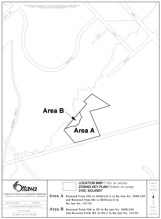
The site is situated at 3150 Solandt Road. Specifically, it is at the western end of the proposed future extension of Solandt Road, immediately west of the Ottawa Hydro Corridor, and immediately north of the Arnprior Nepean Rail Corridor (see Document 1).
Purpose
of Zoning Amendment
The
applicants are seeking two zoning options on this property. They wish to do this through a special
exception to the existing General Industrial zone. The applicants are proposing that the industrial zone development
requirements remain in place in case a future property owner wishes to develop
the lands with light industrial uses.
The special exception would allow the development of a wide range of
residential uses should no industrial uses exist on the subject lands. The
industrial and residential land uses would be mutally exclusive. The trigger as to which zone requirements
would be applicable would be the submission of a plan of subdivision or site plan
identifying the desired land uses.
In addition, an Environmental Protection zone is proposed that respects the flood plain and wetland associated with Shirley's Brook as it runs through this property.
The subject
site is currently zoned General Industrial, Subzone 6 (IG6) under the
Comprehensive Zoning By-law. This zone permits a range of light industrial uses
and allows a variety of complementary uses such as service commercial to serve
the employees of the adjacent Employment Area and the general public. The zone does not allow for residential
development and the flood plain and wetland are not recognized.
The former City of Kanata Zoning By-law designates these lands M2 (General Industrial). This zone allows a range of light industrial, light assembly or light manufacturing uses.
It is proposed to rezone the subject property to General Industrial,
Subzone 6 - Holding (IG6[xxxx]-h). The
special exception for the General Industrial zone will allow the type of
development defined by the Residential Fifth Density Zone, Subzone N (R5N) in
order to permit development of a variety of residential uses that vary in
density from fully-detached residential dwellings to an apartment dwelling on
the site. This new exception zone will permit the same land uses as proposed in
the exception zone for the M2 zone as defined by the former City of Kanata
Zoning By-law. The lands
encompassing the flood plain and wetland associated with Shirley’s Brook will
be zoned Environmental Protection (EP).
The Holding category is
required since issues such as provision of roads, servicing for the lands and
the preparation of an Environmental Impact Statement, still need to be
addressed. In addition, a plan of subdivision needs to be designed in order to
properly review the roads, servicing and environmental issues. The applicant is not requesting any relief
from any of the zone provisions within the Residential Fifth Density N zone.
DISCUSSION
The lands are designated General Urban Area in the Official Plan. This designation permits a broad range of uses from all housing types, to commercial, employment, industrial, parkland and institutional uses.
The Official Plan also contains policies that ensure compatibility between different land uses. These policies recognize that within some designations like General Urban Area, there are broad use provisions. The Plan notes that it is up to the Zoning By-law to establish more specific land use lists in a way that achieves compatibility among proximate uses. The criteria used to establish compatibility will vary depending on the use proposed and its context but may include traffic, access, building height and massing.
Both requested zonings, residential and industrial, would be in compliance with the provisions of the General Urban Area designation.
Under the Comprehensive Zoning By-law, the applicant is proposing to
rezone the lands from General Industrial, Subzone 6 (IG6) to an industrial zone
with a special exception that allows a complete range of residential uses.
Staff is recommending that the Zoning Map of By-law 2008-250 be amended
as detailed in Document 2 to create the IG6[xxxx] and the EP zones. A Holding category will be established in
order to include several requirements that must be met before development on
this property can proceed. The
requirements will address the issues noted below as well as the environmental
concerns.
Staff is also recommending that the zoning for these lands be changed under the former City of Kanata Zoning By-law from M2 to M2S(xx)-h and )OS-1 as detailed in Document 2. As mentioned above, the Holding category will be established in order to include several requirements that must be met before development on this property can proceed.
Transportation
3150 Solandt Road is currently a land-locked parcel which can only be accessed by foot or rail as it abuts the Arnprior Nepean rail corridor. The Official Plan identifies Solandt Road as being a collector road which is to be extended from its current termination point at Hines Road across the MDS Nordion Site, the subject lands and across the railway line to connect to the future extension of Walden Drive in the KNL subdivision. A transportation study undertaken for the KNL subdivision confirmed the requirement for this road link. The construction of Solandt Road is required in conjunction with the development of the KNL lands which have yet to commence. The timing for the construction of Solandt Road is dependant upon the possible need for an Environmental Assessment for the road and associated budget considerations for the study, timing of the development of the subdivision block, and any land negotiations and acquisitions that may be required.
Sanitary and storm servicing will be from the KNL lands and a watermain will be required in Solandt Road between Hines Road and Walden Drive. Servicing will be available once development reaches Walden Drive.
Conclusions
The proposed Zoning By-law amendment is consistent with the policies of the Official Plan and the intent of both Zoning By-laws.
The rezoning of the subject site to allow for the option of development for either residential or light industrial uses is an anticipatory change that reflects the uniqueness of the site and it’s setting. It recognizes that because this parcel sits on the fringe of two different land use communities, it is a reasonable expectation that a future land owner may choose to link the property to one land use type or another and it provides the appropriate zone provisions for each option. The Holding Category provides the means whereby any outstanding technical issues can be satisfactorily addressed before development proceeds.
These zones combined with the isolated setting provide the means for the appropriate development of the subject lands.
ENVIRONMENTAL IMPLICATIONS
There are several environmental implications associated with this proposal. First, the lands are adjacent to an Urban Natural Feature known as Trillium Woods. Official Plan policies state that an Environmental Impact Statement (EIS) is required for any development within 30 metres of the boundary of a designated Urban Natural Feature. The requirements of the EIS are defined in the Official Plan. The applicant submitted a document in support of this application that addresses some of the environmental issues on this site. Mississippi Valley Conservation (MVC) has reviewed this document and believes that it falls short of meeting the requirements of the EIS.
Second, as part of their review, MVC noted that the proposal raises issues regarding fisheries, potential impacts on the adjacent Urban Natural Feature, significant species at risk and tree preservation. None of these issues were examined in depth in the document provided. MVC therefore recommends that these missing elements be included in the EIS and that the work be undertaken during appropriate growing and nesting seasons.
MVC recognizes that there will also be an EIS trigger at the next stage of the development process. Once a subdivision or a site plan is submitted, an assessment of the environmental impacts will be more straightforward. They feel that establishing a holding category will ensure that the full EIS requirements will be met.
Third, Shirley’s Brook runs through this property. The Shirley’s Brook and Watts Creek Subwatershed Study specifies that a 15-metre riparian buffer area, measured on both sides of the watercourse from the centre line is recommended for fish habitats like the one found in this area. MVC noted however, that in this area, the brook consists of braids and wetland. Because of this, they feel that a setback measured from the centerline would be inappropriate and therefore recommend that the 15-metre riparian buffer be measured from the edge of the wetland. They state that the buffer should be a no-touch area, remaining in a natural vegetated state. The rezoning will reflect this setback. It is shown as Area B on the Zoning Key Plan as EP in the Comprehensive Zoning By-law No. 2008-250 and OS-1 in the former City of Kanata Zoning By‑law.
MVC has no objections to the rezoning of these lands based on the use of the holding provision and the establishment of the buffer in the implementing by-law.
Outstanding issues will be addressed as requirements of any future subdivision and/or site plan application and are reflected in the requirements of the Holding Category.
CONSULTATION
Notice of this application was carried out in accordance with the City's Public Notification and Consultation Policy. The Ward Councillor is aware of this application and the staff recommendation.
FINANCIAL IMPLICATIONS
APPLICATION PROCESS TIMELINE STATUS
The application was not processed by the "On Time Decision Date" established for the processing of Zoning By-law amendments due to the complexity of the issues associated with development adjacent to Shirley's Brook and Trillium Woods.
SUPPORTING DOCUMENTATION
Document 1 Location
Map
Document 2 Details of Recommended zoning
Document 3 Consultation
Details
DISPOSITION
City Clerk’s Branch, Council and Committee Services to notify the owner, Northtech Land Development Inc., 495 Richmond Road, Ottawa, Ontario, K2A 4B2, applicant, Novatech Engineering Consultants Ltd. c/o Mr. Adam Thompson, 240 Michael Cowpland Drive, Suite 200, Ottawa, Ontario, K2M 1P6, OttawaScene.com, 174 Colonnade Road, Unit #33, Ottawa, ON K2E 7J5, Ghislain Lamarche, Program Manager, Assessment, Financial Services Branch (Mail Code: 26-76) of City Council’s decision.
Planning, Transit and the Environment Department to prepare the implementing by-law, forward to Legal Services Branch and undertake the statutory notification.
Legal Services Branch to forward the implementing by-law to City Council.
LOCATION MAP DOCUMENT
1
DETAILS OF RECOMMENDED ZONING DOCUMENT 2
Proposed Changes to the Comprehensive Zoning By-law 2008-250
1. The lands shown as Area A on Document 1 will be rezoned from IG6 to IG6[xxxx] and a holding category will be applied to the Zoning Map as IG6[xxxx]-h.
2. The lands shown as Area B on Document 1 will be rezoned from IG6 to EP.
3. The lands shown as Area A on Document 1 will be zoned IG6[xxxx] and in spite of anything to the contrary in By-law 2008-250, the following provisions will apply:
(i) Additional
Permitted Uses:
·
apartment
dwelling
·
detached dwelling
·
semi-detached
dwelling
·
multiple attached
dwelling
·
stacked dwelling
(ii) the
lands will be subject to a holding category shown on the Zoning Map as
IG6[xxxx]-h and the holding category may be lifted by by-law when the following
conditions have been satisfied:
(a) road access to the lands must be provided
(b) servicing to the lands must be provided
(c) an Environmental Impact Statement as defined by clause 4.7.8 of the Official Plan for the City of Ottawa must be submitted to and approved by Mississippi Valley Conservation
(d) a draft Plan of Subdivision or Site Plan must be submitted to and approved by the City of Ottawa
(iii) where
the proposed land use is for low to moderate impact, light industrial uses, the
zone provisions of the IG6 zone apply;
(iv) where
the proposed land use is an apartment dwelling, a detached dwelling, a
semi-detached dwelling, a multiple attached dwelling or a stacked dwelling, the
zone provisions of the R5N zone apply;
(v)
no minimum
frontage is required for a lot on a public street or highway, provided that the
lot abuts a private right-of-way for a minimum of 6.0 metres.
Proposed Changes to By-law 132-93 of the former City of Kanata
1. The lands shown as Area A on Document 1 will be rezoned from M2 to M2S(xx) and a holding category will be applied to Schedule A as M2S(xx)-h.
2. The lands shown as Area B on Document 1 will be rezoned from M2 to OS1.
- Subsection 2.37 of By-law 132-93 is amended by adding the following:
(a) APARTMENT DWELLING, LOW RISE means a residential use building of four or fewer storeys in height containing four or more principal dwelling units, other than a Multiple Attached Dwelling or Stacked Dwelling;
(b) APARTMENT DWELLING,
MID-HIGH RISE means a residential use
building of more than four storeys
in height containing four or more principal dwelling units, other than a Multiple Attached Dwelling;
(c) DETACHED DWELLING means
a residential use building that
contains only one principal dwelling
unit;
(d) SEMI-DETACHED DWELLING means a residential use building containing two attached principal dwelling units that are divided vertically, with each unit having lot frontage except where located within a planned unit development;
(d) MULTIPLE ATTACHED DWELLING means a residential use building containing three or more attached principal dwelling units divided vertically;
(e) STACKED DWELLING means a residential use building of four or fewer storeys in height containing four or more principal dwelling units where the units in each pair are divided horizontally, and the pairs are divided vertically, and in which each dwelling unit has an independent entrance to the exterior.
- The lands shown as Area A on Document 1 will be zoned M2S(xx) and in spite of anything to the contrary in By-law 132-93, the following provisions will apply:
(i) Additional
Permitted Uses:
·
apartment
dwelling, low rise
·
apartment
dwelling, mid-high rise
·
detached dwelling
·
semi-detached
dwelling
·
multiple attached
dwelling
·
stacked dwelling
(ii) the
lands will be subject to a holding category shown on Schedule A as M2S(xx)-h
and the holding category may be lifted by by-law when the following conditions
have been satisfied:
(a) road access to the lands must be provided
(b) servicing to the lands must be provided
(c) an Environmental Impact Statement as defined by clause 4.7.8 of the Official Plan for the City of Ottawa must be submitted to and approved by Mississippi Valley Conservation
(d) a draft Plan of Subdivision or Site Plan must be submitted to and approved by the City of Ottawa
(iii) no minimum frontage is required for a lot on a public street or highway, provided that the lot abuts a private right-of-way for a minimum of 6.0 metres
(iv) clause 5.17(a) does not apply to any yard abutting a railway
(v) zone provisions for detached dwelling, semi-detached dwelling and multiple attached dwelling uses:
(a) front yard depth – minimum: 6.0 metres
(b) distance between main building and
private road in a yard having a driveway
crossing said yard - minimum: 6.0 metres
(c) exterior
side yard width – minimum: 4.5
metres
(d) rear
yard depths – minimum:
-
main building 6.0
meters
-
accessory building 1.0
metres
(e) coverages
– maximum:
-
main building 50%
-
accessory buildings 5%
(f) building
heights – maximum:
-
main building 11.0
metres
-
accessory buildings 4.0
metres
(g) building
separations – minimum:
-
between main buildings 3.0
metres
-
between other buildings 1.0
metre
(h) permitted
storage:
-
all types of storage, except enclosed
storage, are prohibited unless
specifically permitted elsewhere in this
by-law
(vi) zone provisions for a stacked townhouse dwelling use:
(a) front
yard depth – minimum: 6.0
metres
(b) exterior
side yard width – minimum: 6.0
meters
(c) rear
yard depths – minimum:
-
main building 7.5
metres
-
accessory buildings 1.0
metres
(d) interior
side yard widths – minimum:
-
main building 6.0
metres
-
accessory buildings 1.0
meters
(e) coverages
– maximum:
-
main building 45%
-
accessory buildings 5%
(f) buildings
heights – maximum:
-
main building 10.0
metres
-
accessory buildings 4.0
metres
(g) building
separations – minimum:
-
between main buildings 3.0
metres
-
between other buildings 1.0
metres
(h) permitted
storage:
- all types of storage, except enclosed
storage, are prohibited unless
specifically permitted elsewhere in this by-law
(vii) zone provisions for an apartment dwelling use:
(a) lot area – minimum: 4,000 m2
(b) lot
frontage – minimum: 30.0
metres
(c) front
yard depth – minimum: 6.0
metres
(d) exterior
side yard width – minimum: 7.5
metres
(e) rear
yard depth – minimum:
-
main building 7.5
metres
-
accessory buildings 6.0
metres
(f) interior
side yard widths – minimum:
-
main building 6.0
metres
-
accessory buildings 6.0
metres
(g) coverage
– maximum: 45%
(h) building
heights – maximum:
-
main building 22
metres
-
accessory buildings 11.0
metres
(i) building
separations – minimum:
-
between main buildings 10.0
metres
-
between other buildings 1.0
metre
(j) permitted
storage:
-
all types of storage, except enclosed
storage, are prohibited unless
specifically permitted elsewhere in this
by-law
CONSULTATION DETAILS DOCUMENT 3
NOTIFICATION AND CONSULTATION PROCESS
Notification and public consultation was undertaken in accordance with the Public Notification and Public Consultation Policy approved by City Council for Zoning By-law amendments.
PUBLIC COMMENTS
1) There is opposition to rezoning industrial land to residential since the road systems and schools are already overloaded in the City’s west end. More residential development will make these problems worse. Industrial uses should not be forced to relocate to West Carleton or Stittsville.
2) The proposed rezoning is incompatible to adjacent land uses. Increased residential traffic could disrupt the efficient flow of traffic to and from the adjacent industrial sites at critical times during the day and perhaps for other nearby businesses. Has there been a traffic assessment undertaken in the vicinity of the proposed development and specifically in the area?
3) Adjacent businesses could face prospective requests from residential neighbours to modify or limit industrial operations in the future to meet residential needs. This proposed area was designed to be an industrial zone in order to avoid such potential conflicts. What are the principles that guide any proposed change in zoning designation from industrial to residential zoning?
4) Is there adequate green space proposed for the site? In the absence of adequate green space, prospective residential owners may look to neighbouring industrial sites as a unique available green space to utilize. This would impose an unacceptable liability to these companies. Has there been an assessment of green space within and around the proposed site?
SUMMARY OF PUBLIC INPUT
1) Three issues were raised with this comment: school overcrowding, overloading the road system and the loss of industrial land uses. Each will be discussed in turn.
· School Overcrowding: The school boards are actively working to increase the number of schools in the area. The Kanata Lakes Community that is currently being developed immediately south of the subject lands, has one existing elementary school and one existing high school. Two more elementary schools and one more high school are being proposed as part of this development.
· Overloading the Road System: The City’s Transportation Master Plan identifies the Solandt Road connection as a proposed Collector road connection. There have been a number of detailed traffic studies completed in this area over the years, the most recent of which was associated with an approved Draft Plan of Subdivision application for the KNL lands in Kanata Lakes. The approved traffic report supports the need for a connection of the Kanata Lakes lands to the Business Park area to the east through the lands in question. This connection will allow for an alternative outlet for vehicles from the developments and will serve the need for the provision of connectivity between the community and the Business Park areas as well as providing a connection to March Road. This road connection matter was also an item disputed to the Ontario Municipal Board and the Board ruled in favour of the findings of the traffic study to implement the road connection.
· Loss of Industrial Land Uses in Kanata: Although employment activity is permitted in almost all designations in the Official Plan, the Plan works to protect large tracts of land for this function and in so doing designates these lands Employment Area or Enterprise Area. It is within these areas where the City’s economic health is expected to be sustained and enhanced. The Employment and Enterprise Areas are situated throughout the City enabling any prospective employer a variety of choices regarding location. As mentioned above, the subject lands were removed from the Enterprise Area designation and placed within General Urban Area designation. The proposed residential development conforms to current Official Plan policies regarding the type and intensification of land use.
2) The site is bounded by industrial uses to the north and northeast, open space lands to the northwest and west, an Ottawa Hydro Facility site to the east and residential land to the south. The portion of the property that abuts the industrial lands and the Ottawa Hydro facility is the hydro corridor that runs through Kanata from the southeast to the northwest. There are no plans in to develop the lands under the hydro corridor.
The lands zoned Environmental Protection are in fact part of the Urban Natural Feature described above. As mentioned earlier, an EIS will be required prior to the development of this property to mitigate any possible impacts on the Urban Natural Feature and to ensure compatibility. A medium density or townhouse type of development will be compatible with the residential lands to the south. How the traffic will pass through this site is not known at this time and any traffic assessment if required, will be requested at the subdivision or site plan stage of development.
3) The Official Plan of the City of Ottawa contains the policy directions the City will follow when it comes to changing land uses. There are policies within the Plan that work towards designing a proposed development in such a way that it fits in with the existing development even though it may be different. One of the benefits of this approach is that it allows the development of the City to be flexible and able to adapt to changing social and economic needs. There are also policies within the Official Plan that speak to compatibility between land uses within and between areas and even specific sites. These policies require an evaluation of the compatibility of development applications and sets out criteria for this purpose.
The Plan also identifies where the various land use designations will occur in general but notes that the more detailed land use zones are identified within a Zoning By-law. The Official Plan includes as one of its objectives the assurance that there is adequate land available within the Employment Areas and the Enterprise Areas to accommodate the City’s economic needs. If the proposal had been to change the designation from either of these to the General Urban Area designation and represented a significant loss of jobs, a rationale may have been required. As it is, the existing designation allows both employment (which includes industrial uses) and residential land uses. Lands within the General Urban Area designation do not count for much of the total of employment opportunities within the City especially when considering a 4 hectare site.
4) The City requires a dedication of 5% of the total land area (or its monetary equivalent) for greenspace for any new residential development. The City takes this contribution either at the subdivision or the site plan stages. It should be noted that in this situation, more than 30% of the subject lands are within the hydro corridor. This is the same portion of the property that is adjacent to the industrial land uses.