|
2. PROPERTY ACQUISITION - LIMEBANK ROAD WIDENING -
NATIONAL CAPITAL COMMISSION - BALMORAL DRIVE TO LEITRIM ROAD ACQUISITION DE TERRAIN – ÉLARGISSEMENT DU CHEMIN LIMEBANK – COMMISSION
DE LA CAPITALE NATIONALE – DE LA PROMENADE BALMORAL AU CHEMIN LEITRIM |
Committee Recommendation
That Council
approve the acquisition in fee
simple of three (3) vacant parcels of land, consisting of a combined land area
of approximately 7.426ha (18.35 acres), owned by the National Capital
Commission, required for the widening
of Limebank Road, described
as Part of Lots 11 to 16, inclusive, Concession 1, Rideau Front, Geographic
Township of Gloucester, City of Ottawa, and shown as Parcel 1 on the attached
Annex “A”, Annex “B and Annex “C”, respectively, together with temporary construction easements containing a combined land area of
approximately 1.763ha (4.36 acres), shown as
Parcel 2 on Annex “A” and “B”, respectively, all for the
consideration of $1,630,000 plus GST, subject to final adjustments on closing.
Recommandation du comité
Que le Conseil approuve l’acquisition en fief simple de trois parcelles
de terrain non bâties ayant une superficie combinée d’environ 7,426 ha (18.35
acres) et appartenant à la Commission de la capitale nationale, en vue de
l’élargissement du chemin Limebank. Les terrains sont décrits comme une partie
des lots 11 à 16 inclusivement, concession 1, façade rivière Rideau, canton
géographique de Gloucester, ville d’Ottawa, et désignés comme la parcelle 1 aux
annexes A, B et C respectivement. S’y s’ajoutent des servitudes de construction
temporaires ayant une superficie combinée d’environ 1,763 ha (4.36 acres) et
désignés comme parcelle 2 aux annexes A et B respectivement. Le montant de
l’acquisition sera de 1 630 000 $ (TPS non comprise), sous réserve
de rajustements à la clôture.
Documentation
1. Executive Director, Business Transformation
Services’ report dated 4 September 2008 (ACS2008-BTS-RPM-0033).
Report
to / Rapport au :
Corporate Services and Economic Development Committee
Comité des services organisationnels
et du développement économique
and Council / et au Conseil
04 September 2008 / le 04 septembre 2008
Submitted by / Soumis par : Stephen A. Finnamore, Executive Director, Business Transformation
Services / Directeur exécutif, Services de transformation des activités
Contact Person /
Personne ressource : Gordon MacNair, Manager
Real Property Asset Management / Gestion des
actifs des biens immobiliers
(613) 580-2424 x21217,
Gordon.MacNair@ottawa.ca
REPORT RECOMMENDATION
That the Corporate Services
and Economic Development Committee recommend Council approve the acquisition in fee simple of three (3)
vacant parcels of land, consisting of a combined land area of approximately
7.426ha (18.35 acres), owned by the National Capital Commission, required for the widening of Limebank Road, described as Part of Lots 11
to 16, inclusive, Concession 1, Rideau Front, Geographic Township of
Gloucester, City of Ottawa, and shown as Parcel 1 on the attached Annex “A”,
Annex “B and Annex “C”, respectively, together with temporary construction
easements containing a combined land area of approximately 1.763ha (4.36
acres), shown as Parcel 2 on Annex “A”
and “B”, respectively, all for the consideration of $1,630,000 plus GST,
subject to final adjustments on closing.
RECOMMANDATION DU
RAPPORT
Que le Comité des
services organisationnels et du développement économique recommande au Conseil
d’approuver l’acquisition en fief simple de trois parcelles de terrain non
bâties ayant une superficie combinée d’environ 7,426 ha (18.35 acres) et
appartenant à la Commission de la capitale nationale, en vue de l’élargissement
du chemin Limebank. Les terrains sont décrits comme une partie des lots 11 à 16
inclusivement, concession 1, façade rivière Rideau, canton géographique de
Gloucester, ville d’Ottawa, et désignés comme la parcelle 1 aux annexes A, B et
C respectivement. S’y s’ajoutent des servitudes de construction temporaires
ayant une superficie combinée d’environ 1,763 ha (4.36 acres) et désignés comme
parcelle 2 aux annexes A et B respectivement. Le montant de l’acquisition sera
de 1 630 000 $ (TPS non comprise), sous réserve de rajustements
à la clôture.
BACKGROUND
The City of Ottawa initiated a Class Environmental Assessment Study (EA) in March 2000, in order to provide transportation service to the Riverside South Community. The roads under study included Riverside Drive, Limebank Road, River Road, Leitrim Road and Earl Armstrong Road.
In Report ACS2003DEV-POL-0005 to Transportation and Transit Committee, carried by Ottawa City Council 26 March 2003, the Transportation and Infrastructure Planning Division presented the EA recommendations, including:
· The staging plan for the transit priority measures and roadway infrastructure for Gloucester South developed through this assessment. This infrastructure includes car pool lots;
·
Reconstruction
of Riverside Drive (between Hunt Club Road and Limebank Road) from a 2-lane
rural roadway, to a 4-lane divided urban cross section with sidewalks, bicycle
lanes, roadway lighting, traffic control signals, property requirements,
landscaping and safety features, that include geometry improvements in an area
that has a history of fatal collisions;
·
Reconstruction of Limebank Road between River Road
and a point south of Earl Armstrong Road (southern limit of the urban
boundary), from a 2-lane rural cross section to a 4-lane divided urban/rural
facility, including a pedestrian sidewalk, recreational path, bicycle lanes,
roadway lighting, structure over Mosquito Creek, traffic control signals and
property requirements;
·
Modifications for Leitrim Road (between River Road
and Albion Road) to a 2-lane rural cross section with paved shoulders for
bicycles and a future realignment, to accommodate the additional east-west
runway at the Ottawa Macdonald-Cartier International Airport (should the
Airport build a second runway as shown in their Master Plan). Other short-term modifications include the
realignment of the existing offset approaches to Limebank Road;
· Reconstruction of Earl Armstrong Road (between Spratt Road and Albion Road) from a 2-lane rural roadway, to a 4-lane urban divided cross section with sidewalks, bicycle lanes, roadway lighting, structure over Mosquito Creek, traffic control signals, and property requirements;
· The preparation and filing of an Environmental Study Report (ESR) for the above-noted modifications to Riverside Drive, Limebank Road, Leitrim Road and Earl Armstrong Road.
The EA Recommendations
were posted for public review on 30 May 2003 and the EA was approved following
the end of the review on 30 June 2003.
In
June 2007, the City of Ottawa initiated a Federal Environmental Assessment (Screening)
under the Canadian Environmental Assessment Act (CEAA), for the
section of Limebank Road between Balmoral Drive and Leitrim Road, as part of
the Federal Land Use, Design and Transaction Approval process overseen by the
NCC. At the request of the National Capital Commission (NCC), this undertaking
also included a review and update to the design alternatives development and
evaluation process conducted during the Municipal Class EA process, for both
the widening of Limebank Road (including roadway cross-section and horizontal
alignment alternatives), from Balmoral Drive to Leitrim Road, as well as for
the Limebank and Leitrim Road intersection.
The City of Ottawa completed this (Screening) document and has submitted
it to the federal Responsible Authorities for approval.
The
City of Ottawa has also filed a Municipal Class EA Addendum to the Limebank
Road Environmental Study Report (2003), which addresses changes to the
recommended design of Limebank Road between Balmoral Drive and Leitrim Road. The EA Addendum has been made available for
a 30-day public review period as of 11 July 2008. The Federal Environmental Assessment (Screening) report has been
filed as a supporting document.
DISCUSSION
Pursuant to the
Municipal Class EA (2003) and Municipal Class EA Addendum (2008), the
subject of this report is concentrated on the planned widening of Limebank
Road, between Balmoral Drive and a point approximately 240 metres south of
Leitrim Road, for the most part situated immediately west of the Ottawa Macdonald-Cartier International
Airport, from a 2-lane undivided arterial roadway, to a 4-lane divided arterial
roadway with a 5.0 metre median, as well as realignment of the existing
offset approaches to the Limebank Road and Leitrim Road intersection. This
section of the alignment requires approximately 7.426ha (18.35 acres) of land
from the NCC that forms part of the federal Greenbelt.
The proposed modifications to Limebank Road within this section include:
- Expansion to a 50 metre right-of-way;
- Full rural (1.5 metre flat bottom ditch) 4-lane cross section;
- 5 metre curbed median - with median lighting;
- 2.5 metre paved shoulder and 4:1 granular side slope;
- 3.0 metre multi-use asphalt pathway beyond the western limit of right-of-way on NCC property - to be constructed and maintained by the City of Ottawa;
- 4:1 ditch foreslopes - 3:1 ditch backslopes;
- Box culvert crossings of four (4) existing minor tributaries of the Rideau River;
- Re-aligned signalized intersection at Leitrim Road;
- Re-alignment of Tom Roberts Avenue to the north of its present location, to align with the existing Balmoral Drive, at a two-way stop controlled intersection.
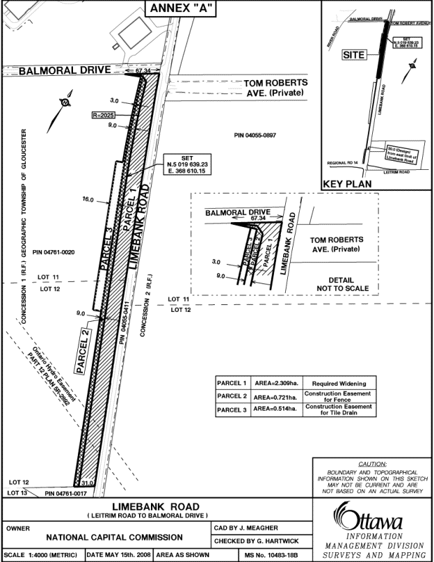
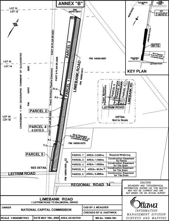
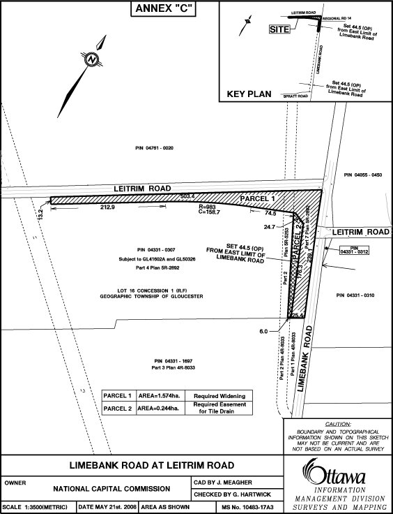
The lands required from the NCC for the road widening are described as
Parcel 1 on the attached Annex “A”, Annex “B” and Annex “C” sketches,
respectively. These parcels comprise an elongated strip of vacant land situated
along the west side of Limebank Road, as well as a section along the south side
of Leitrim Road within the described project area. This is a rural/agricultural
area separating the urban area to the north of Hunt Club Road and the South
Urban Community situated to the south of Leitrim Road, where the NCC lands are
currently tenant occupied and used for agricultural crop production.
At the request of the Public Works and Services Department (PWS) negotiations with the NCC were undertaken to acquire the fee simple interest in the lands required. These were supported by (2) independent appraisals completed on behalf of the City and NCC, respectively, in order to provide an estimate of market value attributable to urban development land staged for future development in an employment use that was agreed to be indicative of the most probable alternate use of the lands. Following an exchange of reports for peer review, this resulted in a negotiated rate of $219,500 per hectare ($88,832 per acre) and total consideration of $1,630,000 for the fee simple interest in the 7.426ha (18.35 acres) of land.
It was also determined that part
of the land requirement for the road widening will cause disturbance damage (relocation of fencing and repair of tile
drain) upon the remainder parcels, that are occupied by (2) agricultural
tenants. The work necessary to address this disturbance and associate
costs will be undertaken by the City at the time construction of this phase of
the project proceeds.
In addition to the above and pursuant to terms and conditions in the NCC Federal Land Use, Design and Transaction Approval for the Limebank Road Widening project, the City agrees to design and construct, at its own cost and expense, a pathway along the west side of the widened Limebank Road from the south side of Balmoral Drive to the north side of (realigned) Leitrim Road. The pathway will be situated on NCC lands but constructed and maintained by the City subject to a Recreational Pathway Agreement. This was agreed to be an alternative to constructing a sidewalk within the limit of the road right of way that would have been the responsibility of the City to construct and maintain.
The costs related to construction of the pathway will be included in
the construction budget for this phase of the road widening project and one (1)
year prior to the service delivery, Surface Operations will request funding for
associated maintenance costs in the prior year Capital Budget. Temporary
construction easements containing a combined land area of approximately 1.763ha
(4.36 acres), shown as Parcel 2 on Annex “A” and “B”, respectively, are
required in order to complete this work will be granted by the NCC as a License
of Occupation for the nominal consideration of $1.00.
The terms and conditions relating to the above real estate transaction
have been formalized in a Memorandum of Understanding, subject to:
1. NCC obtaining all necessary internal approvals including approval from it’s Board of Directors and other necessary governmental approvals including any Treasury Board of Canada and Governor in Council approvals for the sale of the NCC Lands (Note: tentatively scheduled to be considered by NCC Board of Directors 8 September 2008).
2. The City’s approval by Committee and Council.
ENVIRONMENTAL
IMPLICATIONS
As
a condition of Federal Land Use, Design and Transaction Approval, the
Environmental Conditions specify that all mitigation measures identified in the
Limebank Road Widening from Tom Roberts Road to Leitrim Road, City of Ottawa,
CEAA Environmental Screening Report must be implemented.
As part of the environmental due diligence a
Phase I Environmental Site Assessment (ESA) was completed to address issues of
potential environmental concern identified in the vicinity of the subject
lands. The report identified historical
agricultural (farm) use of the lands as a potential source of contamination due
to on site fuel storage, fuelling of equipment, equipment maintenance and the
storage and use of pesticides and fertilizers. As part of the
construction project impacted soils and/or groundwater encountered will be
managed in accordance with Ministry of Environment (MOE) standards.
CONSULTATION
Public consultation was undertaken as part of the environmental assessment process for this project. No other public consultation was undertaken. The Ward Councillors, Councillor Deans and Councillor Desrosches are aware of the project.
FINANCIAL STATEMENT
Approved Budget to Date $32,200,000
Total Paid & Committed ($2,782,024)
Balance Available $29,417,976
THIS REQUEST including GST ($1,711,500)
Balance Remaining $27,706,476
Funds are available in the 2005/2006 Capital Budgets, Order No. 900429 Limebank Road (Riverside-Spratt). Funds Reservation # 10645106.
SUPPORTING DOCUMENTATION
Attached, as Annex “A”, “B” and “C”, respectively, are sketches showing the lands to be acquired.
DISPOSITION
Following Council’s approval, Real Property Asset Management and Legal Services Branches will finalize the transaction.