|
2. FIRE
STATION LOCATION STUDY - PHASE 1 ÉTUDE SUR L’EMPLACEMENT DES CASERNES DE POMPIERS - PHASE 1 |
Committee Recommendations
That Council:
1.
Approve the methodology developed to support the
Station Location Study which was validated by the Ontario Fire Marshal’s
Office.
2.
Approve the identified growth areas in Ottawa as the
next priorities for Fire Services to address based on the approved service
standards.
RecommandationS du Comité
Que le
Conseil :
1.
approuve
la méthodologie mise au point en vue d’appuyer l’étude sur l’emplacement des
casernes, qui a été validée par le Bureau du commissaire des incendies de
l’Ontario.
2.
approuve
les secteurs de croissance soulevés à Ottawa comme étant les prochaines
priorités dont devra s’occuper le Service des incendies conformément aux normes
de service approuvées.
Documentation
1. Deputy City Manager's report Community
and Protective Services dated 8 September 2008 (ACS2008-CPS-OFS-0001).
2. Extract of Draft Minutes, 2 October
2008.
Report to/Rapport au:
Community and Protective Services Committee
Comité des services communautaires et de protection
8 September 2008/le 8 septembre 2008
Submitted by/Soumis par :
Steve Kanellakos, Deputy City Manager/Directeur
municipal adjoint,
Community and Protective
Services/Services communautaires et de protection
Contact Person/Personne ressource : Rick Larabie, Fire Chief
Ottawa
Fire Services/Service des incendies d' Ottawa
(613)
580-2424 x 29411, Rick.Larabie@ottawa.ca
SUBJECT:
|
|
|
|
|
OBJET :
|
REPORT RECOMMENDATIONS
That the Community and
Protective Services Committee recommend that Council:
1. Approve the methodology developed to
support the Station Location Study which was validated by the Ontario Fire
Marshal’s Office.
2. Approve the identified growth areas in
Ottawa as the next priorities for Fire Services to address based on the
approved service standards.
RECOMMANDATIONS DU RAPPORT
Que le Comité des services
communautaires et de protection recommande au Conseil :
1. d’approuver
la méthodologie mise au point en vue d’appuyer l’étude sur l’emplacement des
casernes, qui a été validée par le Bureau du commissaire des incendies de
l’Ontario.
2. d’approuver
les secteurs de croissance soulevés à Ottawa comme étant les prochaines
priorités dont devra s’occuper le Service des incendies conformément aux normes
de service approuvées.
EXECUTIVE SUMMARY
Ottawa Fire Services requested funding through the 2005 budget process to conduct an in-depth Fire Station Location Study that would result in a comprehensive Risk Assessment for the City of Ottawa; set a standard of service for areas of the City based on their identified risk; and, make recommendations with respect to future growth areas and their eventual requirement for an equalization level of fire service. Council approved that budget request. Consequently the Fire Services contacted the Ontario Fire Marshal’s Office (OFM) to enlist their assistance and expertise in the development of the Ottawa study.
Components of a Station Location Study include identifying: (1) levels of risk throughout the City; (2) desired response times to those risk areas and (3) the speed at which fire resources can travel to get to those risk areas based on existing and projected road networks. Depending on the desired response time, appropriate resources needed to address risk in the area and the speed with which resources can travel, the desired location of fire stations can be identified.
Using sophisticated methodology and advanced technical tools, Ottawa Fire Services has utilized available data and have been able to identify standards of response needed to address levels of risk. This process has allowed them to develop an approach that can be used now and into the future to inform the fire service with respect to deployment that will best meet the needs of Ottawa and its citizens.
RÉSUMÉ
Le Service des incendies d’Ottawa a
demandé des fonds dans le cadre du processus budgétaire de 2005 dans le but de
procéder à une étude approfondie sur l’emplacement des casernes de pompiers qui
donnerait lieu à une évaluation approfondie des risques pour la Ville d’Ottawa,
d’établir une norme de service pour les secteurs de la Ville selon leur niveau
de risque déterminé et de faire des recommandations en ce qui a trait aux
secteurs de croissance future et à leur exigence éventuelle de répartition
équitable des services des incendies. Le Conseil a approuvé cette demande
budgétaire. Par conséquent, le Service des incendies a communiqué avec le
Bureau du commissaire des incendies de l’Ontario (BCI) afin de s’assurer le
concours du bureau et son expertise dans l’établissement de l’étude pour Ottawa.
Les volets d’une étude sur
l’emplacement des casernes comprennent notamment les suivants :
(1) déterminer les niveaux de risque dans l’ensemble de la Ville,
(2) déterminer les temps de réponse souhaités à ces secteurs à risque et
(3) définir la vitesse à laquelle les ressources des incendies peuvent se
déplacer jusqu’à ces secteurs à risque selon les réseaux routiers existants et
prévus. Selon le temps de réponse souhaité, les ressources appropriées
nécessaires pour remédier au risque dans le secteur et la vitesse à laquelle
les ressources peuvent se déplacer, il est possible de déterminer l’emplacement
souhaité des casernes de pompiers.
À l’aide d’une méthode perfectionnée
et d’outils techniques avancés, le Service des incendies d’Ottawa s’est servi
des données disponibles et a été en mesure de déterminer les normes de réponse
nécessaires pour diminuer les niveaux de risque.
Ce processus a permis au service de
mettre au point une approche qui peut être utilisée maintenant et dans le futur
pour informer les services des incendies quant aux ressources à déployer, de
façon à mieux répondre aux besoins d’Ottawa et de ses citoyens.
BACKGROUND
Following amalgamation of the nine fire services in January 2001, Ottawa Fire Services is now a composite municipal Fire Service composed of career and volunteer firefighters. Currently, there are approximately 1300 firefighters delivering service from forty-three fire stations – career firefighters staff twenty-seven (27) stations (4 of which combine career and volunteer resources) and sixteen (16) stations are serviced by volunteer firefighters. Collectively, they provide service to approximately 890,000 residents across 2,796 square kilometres.
At amalgamation, the Ottawa Transition Board (OTB) identified potential transition savings of $2.4M to be achieved from Fire Services. These savings were to be achieved through the reduction of management that would occur by reducing the number of Fire Services from nine (9) to one (1) and through the reduction of fire stations. The station reductions were presumed to be achievable as a result of the removal of former municipal boundaries and employing a best station response.
In 2002, Ottawa Fire Services brought forward a Service Delivery Model (ACS2002-EPS-FIR-004) for Council’s consideration that outlined the Organizational Structure and a high-level deployment model intended to achieve the required savings identified by the OTB. However, at the time of transition and during the development of the subsequent Deployment Model Report in 2002, there was limited access to consolidated data and technology upon which to make decisions. The Fire Service was still working under 8 separate dispatch centres collecting data in a number of different systems. As a result, savings identified by staff were put forward to Council at that time and were based predominantly on manual data collection and analysis and educated recommendations from Fire staff that had worked in the department for many years. The savings through station closures put forward by Fire Services in 2002 were rejected by Council and were rejected again in 2004 when the same options were presented as a potential solution to budget reduction requirements identified through the Universal Program Review.
Subsequently, Ottawa Fire Services requested funding through the 2005 budget process to conduct an in-depth Fire Station Location Study that would result in a comprehensive Risk Assessment for the City of Ottawa; recommend a standard of service for areas of the City based Ontario Fire Marshal (OFM) guidelines and on risk; and, make recommendations with respect to future growth areas and their eventual requirement for a standardized level of fire service. Council approved that budget request and Fire Services subsequently contacted the OFM to enlist their assistance and expertise in the development of the Ottawa study. Fire Services put a project team together and began to develop the terms of reference for this project in August of 2005.
Role of the Fire Marshal’s
Office
The lead for the Fire Station Location Study project team as well as several other team members were provided by the OFM. They had expertise in conducting similar, albeit smaller, studies in other municipalities in the province. Consequently, they were able to provide direction on the project plan and managed the quality and validity of the deliverables.
In addition, they conducted “on site” interviews with staff at various fire stations in Ottawa to ensure interim findings were consistent with reality. They maintained continual contact with the staff in Ottawa to ensure compliance with OFM guidelines and accountabilities.
The OFM staff that worked on the project were instrumental in presenting the findings to the OFM, managing compliance with all appropriate guidelines and ultimately in attaining the OFM’s endorsement of the subsequent study. Given the enormity and sophistication of the Ottawa study, the OFM now have staff that are knowledgeable in completing a study of this magnitude and can provide that expertise to other municipalities in Ontario.
DISCUSSION
In order to identify the location of stations required in future growth areas and to avoid unnecessary redundancy, Ottawa Fire Services worked with the OFM and City staff to develop a methodology that would support station location recommendations in the future. Ottawa Fire Services began meeting with the Ontario Fire Marshal staff in September, 2005 and developed an approach that would see the use of three (3) years of historical fire response information, census data and building data, projected growth data and road network data available at the City.
Comprehensive Methodology
Technical Tools
Unlike the previous deployment
recommendations made in 2002, staff had access to multiple years of electronic
fire response data, which included the number and address of fire calls from
the RMS system and alarm levels, electronic fire response grids and dollar loss
data from Computer Aided Dispatch (CAD).
Staff also had access to census data and City statistics, including
property numbers and values, average economic property values, square footage
information and historical value data.
As well, the team accessed the road network data available in the
Enterprise GIS system from the City.
This data in combination was utilized employing a spatial
analysis tool called ArcGIS Spatial Analyst.
ArcGIS
ArcGIS is a
software tool that enabled staff to overlay various themes of data on to a map
of the City of Ottawa. Consequently
staff were able to overlay location of facilities, roadways including
attributes such as one-way streets and turn restrictions, building and
population densities, etc.
Specifically for Ottawa Fire Services, this tool allowed staff to plot densities – population and buildings, historical buildings, and other features, which illustrated proposed risk levels for specific areas of the City. As well, staff were able to designate attributes to road types which later allowed them to propose travel speeds based on types of roads. With the modeling capability, staff could add or remove potential fire stations and then run “what if” scenarios to determine how far resources could travel in an allotted time period, which allowed them to determine if the proposed response time standards could be met given the location of stations.
Station Location Study
Components of a Station Location Study include identifying: (1) levels of risk throughout the City; (2) desired response times to those risk areas, and (3) speed at which fire resources can travel to get to those risk areas based on existing and projected road networks. Based on the desired response time, appropriate resources required and the speed with which resources can travel, the desired location of fire stations can be identified.
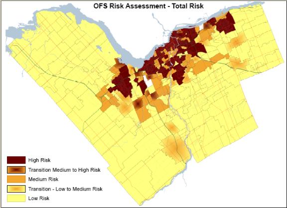
(1) Risk assessment
The Ottawa Fire Services risk assessment process was guided by the main principles of the Ontario Fire Marshal’s Comprehensive Fire Safety Effectiveness Model and included construction age, type of occupancy, exposure risk (risk of fire spread based on proximity of other buildings) and the risk that the combination of these factors pose. The Ontario Fire Marshal mandates that every community should carefully assess its fire risk and that the results of this risk assessment should be used as a basis for determining the level, type and amount of fire protection provided.
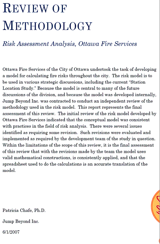
Not many communities have developed a risk assessment to the level of detail and sophistication as the one created by the City of Ottawa and as such there was little supporting research to assist staff in identifying the best approach to developing such a complex risk assessment. As a result, staff used various components of other risk assessment processes to develop a made in Ottawa approach. The final risk assessment for Ottawa was a collaborative effort between Ottawa and the Fire Marshal’s Office and was a compilation of 18 months worth of work. To ensure that final assessment resulted in a model that is consistent with practices in the field of risk analysis and conformed to valid mathematical constructions that were consistently applied, Dr. Patricia Chafe, Ph.D, an outside consultant in the field of risk assessment analysis, reviewed and validated the final risk assessment methodology and findings (Document 1). The Ottawa Fire Services now has a risk assessment methodology that is both repeatable and updateable as new data become available and can be used to make informed decisions on Fire Service deployment in the future.
Using data that was available through the City’s Corporate planning group, the Census, the Fire Services RMS and CAD systems and GIS technology, Fire staff identified the data that was appropriate to best indicate fire risk. Contributory data such as property values, population counts, building type, size and use were analyzed. Each factor was given a “weight” using a formula to determine the potential, frequency and consequence of an event as it related to life loss, property loss, economic loss and historic loss.
This weighting system resulted in a fire risk for Ottawa based on Life Lost Risk, Property Risk, Economic Risk and Historical Risk. The greater the risk to the community the greater the weight that is assigned.
The levels of risk identified through this methodology confirmed that in most instances the former urban, suburban and rural areas of the city were in fact in general alignment with a high, medium and low risk areas as identified by the risk assessment. The results indicated that, in general, those areas of the City with high population and building density, high potential for economic loss and historical loss in the event of an incident -“downtown core” - were deemed as a “high risk” area of the City.
Likewise, those areas with medium population and building density and medium risk for economic and historical loss – suburban areas - were given a rating of medium risk. Finally, those areas with low densities of population and buildings with lower potential economic and historical loss – rural areas - were rated as low risk areas in the City.
(Document 2)
(2) Standards of Response
Before staff can make recommendations on Fire Station Locations, a level of response (how fast and how many resources should respond to a fire) must be identified.
There are two separate standards, which when combined, fire services propose be the standard of response for the City of Ottawa.
Ontario
Fire Marshal’s Guidelines
Per the Ontario Fire Marshal’s Public Fire
Safety Guidelines PFSG 04-08-12, in urban and suburban areas of a City, Fire
Services should provide 10 fire fighters in 10 minutes 90% of the time to
single-family dwelling fires. This
guideline is intended to ensure sufficient resources are in attendance to
provide fire suppression or rescue efforts as required. A detailed analysis of 3 years of historical
response time data for City of Ottawa and using mapping capabilities explained
earlier in this report indicate that the City of Ottawa currently meets this
guideline in the majority of both urban and suburban areas of the City.
However, the Ontario Fire Marshal’s Office
recognized during the development of this standard that 10 firefighters in 10
minutes, 90% of the time, may be unachievable in some rural and/or remote areas
of a municipality. For example, in remote areas of some municipalities, it may take 20 minutes
or longer to respond to a fire situation. In these cases, it is not possible to
meet the 10-minute expectation of the guideline. Nevertheless, a municipality
can still achieve the spirit and intent of the Fire Protection and Prevention
Act, 1997 (FPPA) by compensating for its staffing limitations through enhanced
public education and fire prevention activities and programs. As is the case in Ottawa, rural and remote areas of the city do not always
receive 10 firefighters in 10 minutes 90% of the time. Consequently, Ottawa Fire Services has
implemented a more stringent and appropriate fire prevention program in the
rural areas.
It is important to note that this Public Fire Safety Guideline is based on response requirements to single-family dwellings only.
In addition to adhering to the Fire Marshal’s response standard for single-family dwellings, Ottawa Fire Services have identified a response standard for initial resources based on their newly created Comprehensive Risk Assessment.
In order to determine the current standard of initial response – how fast Fire Services is currently responding to calls – staff reviewed 2 years of data (Jan 2004 – December 2005) available in their Records Management System (RMS).
All Level 1[1] Fire calls (24,000 responses in total) were reviewed and analyzed by individual fire station response grids[2]. Results indicated that stations in the “downtown core” area received a first vehicle response time of 5 minutes at the 90th percentile, which generally aligned with high-risk areas.
Areas of the city, which had medium risk (predominantly the areas of the City which would be classified as suburban), received an initial response time of 7 minutes in the 90th percentile and areas of the city with low risk (rural areas) received an initial response time of 14 minutes at the 90th percentile. [3] These initial response resources are critical as they are the resources that set up an incident command on scene, ready the scene for fire attack and request additional and specialty resources as required to deal with multiple unit dwellings, high density addresses and vulnerable addresses – i.e., hospitals. In the absence of legislated initial response time standards for Fire Services, the Ottawa Fire Services staff propose that the historical standard of initial response be an appropriate standard to be maintained in the future.
This initial response standard (5, 7 & 14 minutes) in conjunction with the Fire Marshal’s 10 firefighters in 10 minutes 90% of the time to a single family dwelling standard is proposed as the combined “Standard of Response” in the future for the City of Ottawa. This standard has been endorsed by the Ontario Fire Marshal.
(3) Road Assessment Process
In order to accurately project where future stations should be located, staff had to determine average travel speeds for various types of roads. In addition, staff needed to determine which types of roads would be built in future growth areas. Depending on the anticipated road type and the speed at which fire resources can travel on those road types, staff can identify the station location based on response time required for the anticipated level of risk.
Travel Times
Response Time = Dispatch time[4] + assembly time[5] + travel time[6]
Travel time can be defined as the total response time less the dispatch and assembly times. As a result, when achieving a response time of 5 minutes in the high-risk areas, as is the current standard of response, the actual travel time is 2 minutes and 56 seconds, when the dispatch and the assembly time is removed. Likewise, in order to achieve a 7-minute response time in the medium risk area (which is the current standard of response), the actual travel time is 4 minutes and 40 seconds when dispatch and assembly times are removed.
Finally, in order to achieve a 14-minute response time in the low risk areas of the city, a total travel time of 10 minutes is allowed when removing dispatch and assembly times.
Road speeds
In order to determine road speeds, staff reviewed two years of actual fire response time data. Road speed was determined by removing dispatch time and assembly times from the response times (travel time). The actual travel time was then measured over the actual distance travelled to result in travel speeds. The travel speed was then modeled using the GIS tool (ESRI Network Analyst), which was then used to develop average road speed for certain types of roads. Table 1 illustrates that estimated road speeds based on type of roads.
Table 1: Road Speed
|
Service Area |
Primary (Non congested) |
Secondary (Congested) |
Highway |
|
Urban |
45 km/h |
35 km/h |
70 km/h |
|
Suburban |
50 km/h |
40 km/h |
80 km/h |
|
Rural |
65 km/h |
50 km/h |
90 km/h |
The travels times in conjunction with road speeds from Table 1 form the basis for ongoing scenarios - including potential station and vehicles locations required to achieve a risk based standard of response.
Road Networks
In order to predict road speeds in future growth areas and ultimately the location of required stations, staff needed to model road networks for use in the GIS system. Staff used existing similar road development to model road networks for planned growth areas.
Based on the models, staff used the ESRI Network Analyst tool to run scenarios and place stations in locations that would result in travel speeds and ultimately response times in accordance with the proposed standard required to meet the anticipated risk level for the new area.
Findings
Interim
Using the ArcGIS network analysis software, Ottawa Fire Services was able to develop a Comprehensive Risk assessment that identified various levels of risk through out the City as well as illustrate for Fire Services where they had current and future vulnerabilities based on that risk assuming the proposed service standard.
During the evaluation of response capabilities in various parts of the city, it was found that there were deficits in 10 firefighters in 10 minutes coverage. As a result, in July 2007 adjustments to current deployment were made to address these shortages. The main adjustments to deployment entailed reallocating resources from Coventry Road Station to the Barrhaven Station so that the area would be served with a 10 firefighters in 10-minute 90% of the time. These adjustments were handled within the current daily operations, however any increased requirement for resources will require Council endorsement.
Planned and Future Growth Requirements
During the station location study process, City of Ottawa planning staff provided information to support the evaluation of Fire Service needs in the future. Used as part of the examination was the Vacant Urban Residential Land Survey (VURLS), Vacant Industrial Land Survey (VILS) and the Rural Residential Land Survey. This allowed staff to map out locations of anticipated new growth (by type) over the next 5 years. Based on this planned development, Ottawa Fire Services was able to identify level of risk for those growth areas based on the type and density of the intended growth. With level of risk projected using the newly developed risk assessment, staff propose these areas receive a standard of response similar to other areas of the city with similar risk levels. In addition, using the corporate desktop GIS Software’s modeled road network and speeds functionality, Fire Services predicted travel times and hence station locations needed to achieve an appropriate response standard based on risk.
Based on the methodology described above and the projected growth data available at the time, staff from Ottawa Fire Services in conjunction with the Ontario Fire Marshal’s Office had identified three areas of Ottawa – Kanata, Barrhaven, and Orleans - that would require additional fire services to meet the needs of growing communities. In all three instances, the level of risk associated with the development areas would have been medium and as such should receive a standard of initial response of seven (7) minutes and 10 firefighters in 10 minute 90% of the time response standard to single-family dwellings.
Growth in these areas was expected to see an increase in population by almost 21,000 in Nepean South in the area bordered by Strandherd Rd to the North, Bowsville Rd to the East, the 416 to the West and Barnsdale Rd to the South. Growth in Orleans is predicted to be 11,000 in the area South of Innis Rd, West of Trim Rd, North of Navan Rd and East of Renaud Rd. Growth in the area of Kanata bordered by March Rd to the North, Eagleson Rd to the East, Huntmar Rd to the West and Huntley Rd to the South is predicted to be 27,000 between 2006 and 2011. Further, the population was expected to increase by 31% in Orleans by 2021 with Kanata and Nepean South seeing populations almost doubling in the same time period.
However, in November 2007, Council considered report ACS2007-PTE-POL-0068, which provided “New Growth Projections for 2006-2031: Adoption of reference projection as basis for Official Plan Review”. In that report, staff recommended that the city adopt revised projections which reflected a 5% decrease in population for the year 2031 from that which was projected in the 2003 Official Plan for 2021 (ten years earlier) and which had been used by Fire project staff to plan the location of new stations. These new numbers, which were endorsed by Council, reflect overall city-wide projected growth. Staff have not yet identified projected growth numbers by neighbourhoods. The process for determining where growth will occur is currently underway as part of the Official Plan review process and is not anticipated to be adopted by Council until March 2009. While Fire Services had already completed the work necessary to determine where future stations are needed to address growth, the work was based on 2006 projected growth data, which was higher than the new restated growth that was approved by Council in late 2007.
Staff anticipates that the updated numbers will continue to identify these neighbourhoods as the areas of Ottawa that will see significant growth over the next number of years. However, the new projections may not see growth occurring at the original rate. Consequently, the timing of the proposed stations will need to be reviewed when the final neighbourhood projected growth becomes available in early 2009.
The new tool developed for fire services allows staff to review and validate the risk assessment and deployment options as new data becomes available.
CONCLUSION
Through a comprehensive and methodical approach to a Fire Station Location Study, Ottawa Fire Services has been able to use three years of actual fire data and current and future demographic information available from the City to develop a detailed risk assessment; propose standards of response to address levels of risk and identify travel speeds for fire resources based on road types. As a result, staff can now use the GIS technology to determine where future resources will be required to support projected growth. The methodology has been reviewed and validated by both the Ontario Fire Marshal’s Office and an outside Risk Analysis expert as sound and repeatable as new data becomes available. With this technology and process now available, Ottawa Fire Service staff anticipates reporting to Council in the fall of 2008 with potential opportunities to align existing resources with existing risk in anticipation of being able to identify some cost avoidance opportunities associated with anticipated growth in the future.
CONSULTATION
The Ontario Fire Marshal’s Office has been
consulted in the development of this report as well as staff from the City of
Ottawa Planning branch.
FINANCIAL IMPLICATIONS
There are no direct financial implications
associated with this report. Subject to
approval of this report, any change in resource requirements identified by
application of the methodology described in this report will be identified in
future reports to Council.
SUPPORTING DOCUMENTATION
Document 1: Validation Letter
Document 2: Map 1 – Areas of Fire Risk
DISPOSITION
The Community and Protective Services Department will action any direction received as part of consideration of this report by Committee and Council.
DOCUMENT 1
Document 2
Risk Map