|
2. SALE OF LAND BEhind 1063 BANK STREET VENTE
DE TERRAIN situÉ DERRIÈRE 1063, RUE BANK |
COMMITTEE RECOMMENDATIONS
That Council:
1. Declare
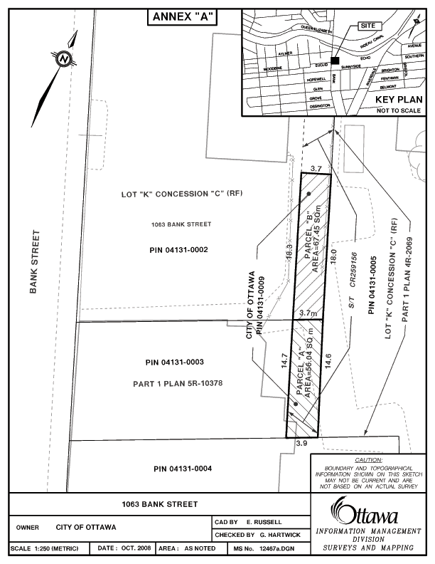
a parcel of vacant land containing an area of 123.49 m2,
subject to final survey, described as part of Lot K, Concession C (Rideau
Front) geographic Township of Nepean now City of Ottawa, shown as Parcel “B” on
the attached Annex “A”, as surplus to the City’s needs; and
2.
Approve the sale of the land outlined in Recommendation 1, subject to any
easements that may be required, to Cal Barber Investments Limited for
$29,000.00 plus GST, together with associated costs, pursuant to an Agreement
of Purchase and Sale that has been received.
RECOMMANDATIONS DU COMITÉ
Que le Conseil:
1.
déclare
excédentaire aux besoins de la Ville, un terrain vacant d’une superficie de
123,49 m2, à confirmer par arpentage, décrit
comme une partie du lot K, concession C (façade rivière Rideau), canton
géographique de Nepean, maintenant la ville d’Ottawa, et illustré par les
parcelles A et B à l’annexe A; et
2.
approuve la vente du terrain décrit
comme parcelle B dans la recommandation 1, sous réserve des servitudes
requises, à la société Cal Barber Investments Ltd., moyennant la somme de 29
000 $ (TPS non comprise) plus les frais connexes, conformément à la convention
d’achat-vente qui a été reçue.
DOCUMENTATION
1. City
Manager’s report dated 17 February (ACS2008-CMR-CPO-0018).
Report
to/Rapport au :
Corporate Services and Economic Development
Committee
Comité des services organisationnels et du développement économique
and Council / et au Conseil
17 February 2009 / le 17 février 20099
Submitted by/Soumis par: Kent Kirkpatrick, City Manager / directeur municipal
Contact Person/Personne ressource : Gordon MacNair,
Manager Real Estate Services, Corporate Project Office/ gestionnaire, Services
immobiliers, Bureau des projects municipaux
(613)
580-2424 x 21217, Gordon.MacNair@ottawa.ca
SUBJECT:
|
|
|
|
|
OBJET :
|
REPORT RECOMMENDATIONS
That the Corporate Services
and Economic Development Committee recommend Council:
1.
Declare a parcel of vacant land containing an area of
123.49 m2, subject to final survey, described as part
of Lot K, Concession C (Rideau Front) geographic Township of Nepean now City of
Ottawa, shown as Parcel “B” on the attached Annex “A”, as surplus to the City’s
needs; and
2.
Approve the sale of the land outlined in Recommendation
1, subject to any easements that may be required, to Cal Barber Investments
Limited for $29,000.00 plus GST, together with associated costs, pursuant to an
Agreement of Purchase and Sale that has been received.
RECOMMANDATIONS DU RAPPORT
Que le
Comité des services organisationnels et du développement économique recommande
au Conseil:
1.
De
déclarer excédentaire aux besoins de la Ville, un terrain vacant d’une
superficie de 123,49 m2,
à confirmer par arpentage, décrit comme une partie du lot K, concession C
(façade rivière Rideau), canton géographique de Nepean, maintenant la ville
d’Ottawa, et illustré par les parcelles A et B à l’annexe A; et
2.
D’approuver
la vente du terrain décrit comme parcelle B dans la recommandation 1, sous
réserve des servitudes requises, à la société Cal Barber Investments Ltd.,
moyennant la somme de 29 000 $ (TPS non comprise) plus les frais connexes,
conformément à la convention d’achat-vente qui a été reçue.
BACKGROUND
The subject property is a 123.49 m2 parcel of vacant land shown on the attached Annex A sketch as Parcels “A” and “B”. This 3.7m wide strip of land is part of a right-of-way corridor that was established many years ago along the rear yards of properties situated between 1049 and 1065 Bank Street. Rights-of-way for passage over the entire corridor were granted to each abutting owner. However, over the years most of this corridor has been physically assimilated by the abutting properties, and although a right-of-way exists on title, vehicular travel along the corridor has not been physically possible for many years.
In 1946 the
former City of Ottawa acquired both Parcels “A” and “B” by a tax arrears
process. As a result of its size, lack
of road frontage, and the fact that it is accessible only to abutting owners,
the property is considered to be a non-viable development entity. Since it is subject to a right-of-way in
favour of several other owners, it must remain undeveloped until such time as
the rights-of-ways are released.
DISCUSSION
Following receipt of a request from an adjacent property owner to purchase the portion of the subject property abutting 1063 Bank Street, an agreement was reached with Cal Barber Investments Limited to purchase Parcel “B” for $29,000.00, plus appraisal and survey costs. The sale will be subject to rights-of-way in favour of various other owners and together with a right-of-way over the remainder of the corridor. The sale will also be subject to any easement that may be required.
The abutting property at 1063 Bank Street is a 1,306 m2 holding improved with a 1 storey commercial building, which is currently being operated as an automotive repair shop and used car sales lot. The purchaser intends to incorporate the subject parcel with its existing used car lot. The use is consistent with the current TM2 H(15) – Traditional Main Street Zone.
City policy requires the sale of property to be on the basis of market value. An appraisal confirms the recommended sale price of $29,000.00 to be consistent with current market values for comparable lands in the area.
The offer is considered fair and reasonable and is recommended for approval.
ENVIRONMENTAL IMPLICATIONS
The subject property does not contain natural environment lands designated as significant in the Official Plan or areas identified in the Urban Natural Areas Environmental Evaluation Study (March 2006). No significant implications to the natural environment have been identified for the proposed sale of this property to the adjacent property owner.
CONSULTATION
In accordance with policies approved by City Council on
14 November 2001, the availability of the property was circulated to all client
City Departments, including the Affordable Housing Division, Infrastructure
Services and Community Sustainability and City Operations, to determine if the
parcel should be retained for a City mandated program. The Environmental Sustainability Division of
the Infrastructure Services and Community Sustainability Department was
consulted with respect to the Urban Natural Area Environmental Evaluation Study
and Greenspace Master Plan, their comments are indicated under the
Environmental Implications section of this report. Neither the Affordable Housing Division nor any City Department
expressed interest in retaining the property.
The utility companies were also circulated and no requirements were indicated.
The following Advisory Committees have been circulated:
Local Architectural Conservation Advisory Committee (LACAC)
Ottawa Forests and Greenspace Advisory Committee (OFGAC)
Environmental Advisory Committee (EAC)
Parks and Recreation Advisory Committee (PRAC)
Roads and Cycling Advisory Committee (RCAC)
Pedestrian and Transit Advisory Committee (PTAC)
Rural Issues Advisory Committee (RIAC)
The subject property is a non-viable parcel with access available only to abutting owners. No concerns were expressed with respect to the sale of the subject property to the abutting owner.
The ward Councillor was made aware of the intent to dispose of the subject property through circulation process and by subsequent notification. The community association’s planning committee has reviewed the matter and has expressed no concern over the proposed sale. The ward Councillor is in agreement that no further community consultation is required.
HOUSING FIRST POLICY
The Official Plan policy directs that the City make land available for affordable housing and give priority for the sale or lease of surplus City-owned property for this purpose.
The Housing First Policy, approved by Council on 13 July 2005, establishes priority consideration to the Housing Branch in the identification of potentially surplus City-owned property, to be used in achieving the City’s affordable housing program targets. The policy also requires that the Official Plan target of 25% affordable housing, be met on any City-owned property sold for residential development. Where viable, residential properties are disposed of without a condition requiring an affordable housing component, 25% of the proceeds from the sale are to be credited to a housing fund, to be used for the development of affordable housing elsewhere in the City.
The subject property is a non-viable property in a commercial zone and therefore does not meet the affordable housing criteria outlined in the Housing First Policy.
LEGAL/RISK MANAGEMENT IMPLICATIONS:
There are no legal/risk management impediments to implementing any of the recommendations arising from this report.
FINANCIAL IMPLICATIONS
All revenues received by the Corporation for the sale of the land, will be credited to the City’s Sale of Surplus Land Account.
SUPPORTING DOCUMENTATION
Attached as Annex "A" is a sketch showing the surplus property.
DISPOSITION
Following Council’s approval Corporate Project Office and Legal Services Branches will finalize the transaction.