|
3. PROPERTY ACQUISITION - LIMEBANK ROAD WIDENING – RIVERSIDE SOUTH
DEVELOPMENT CORPORATION AND
URBANDALE CORPORATION – LEITRIM
ROAD TO SPRATT ROAD ACQUISITION DE TERRAIN – ÉLARGISSEMENT DU CHEMIN LIMEBANK –
SOCIÉTÉ D’AMÉNAGEMENT RIVERSIDE SUD ET SOCIÉTÉ URBANDALE –
DU CHEMIN LEITRIM AU CHEMIN SPRATT |
COMMITTEE RECOMMENDATIONS
That Council approve the acquisition of vacant parcels of land required for the widening of Limebank Road, together with the acquisition of permanent easements
consisting of the following real property:
1.
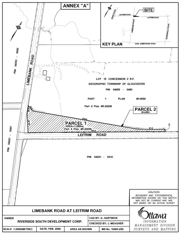
Approximately 1.26ha (3.13
acres) owned by the Riverside South Development Corporation, referred to as part of PIN
04055-0450 and described as being Part of Lot 15, Concession 2 (Rideau Front),
Geographic Township of Gloucester, now in the City of Ottawa, designated Part 4
on Plan 4R-23239, which is shown as Parcel 1 on the attached Annex “A”, as well
as an Easement Interest to benefit
Hydro Ottawa for the installation of a pole guy-wire anchor, all for the
consideration of $332,616 plus GST, subject to final adjustment on closing;
2.
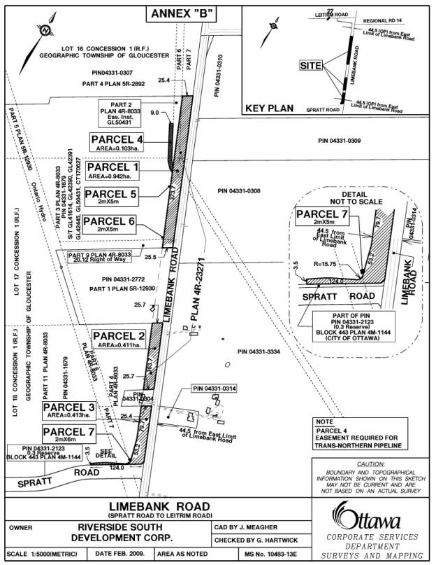
Approximately 1.77ha (4.38
acres) owned by the Riverside South Development Corporation, referred to as part of PIN
04331-1679 and described as being Part of Lots 16, 17 and 18, Concession 1
(Rideau Front) and Part of Block 443 Registered Plan 4M-1144, Geographic
Township of Gloucester, now in the City of Ottawa, designated Parts 1, 2, 4, 5,
7, 10, 11, 12, 13, 14 and 15 on Plan 4R-23271 which are shown as Parcels 1, 2
and 3 on Annex “B” attached hereto, as well as an Easement Interest of
approximately 0.10ha (0.25 acres) in Part of Lot 16, Concession 1 (Rideau
Front), Geographic Township of Gloucester, now in the City of Ottawa,
designated Part 3 on Plan 4R-23271, which is shown as Parcel 4 on attached Annex
“B”, and Easement Interests to benefit
Hydro Ottawa for the installation of three pole guy-wire anchors, all
for the total consideration of $541,471 plus GST, subject to final adjustments
on closing; and
3.
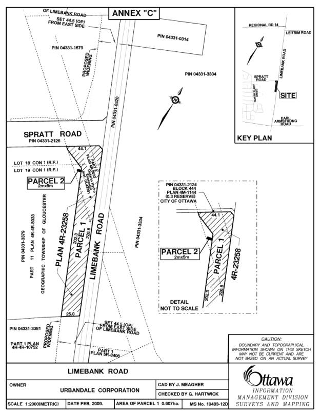
Approximately 0.60ha (1.50
acres) owned by Urbandale Corporation, referred to as part of PIN 04331-3379 and described as
being Part of Lots 18 and 19, Concession 1 (Rideau Front) and Part of Block 444
Registered Plan 4M-1144, Geographic Township of Gloucester, now in the City of
Ottawa, designated Parts 1, 2, 3, 4 and 5 on Plan 4R-23258, which is shown as
Parcel 1 on the attached Annex “C”, as well as an Easement Interest to benefit
Hydro Ottawa for the installation of a pole guy-wire anchor, all for the consideration of $437,035 plus GST, subject to final
adjustments on closing.
RECOMMANDATIONS DU COMITÉ
Que le Conseil approuve l’acquisition de
parcelles vacantes de terrain nécessaires pour élargir le chemin Limebank et l’acquisition de servitudes permanentes comprenant les
biens-fonds suivants :
1.
Environ 1,26 ha
(3,13 acres) appartenant à la Société d’aménagement Riverside Sud, segment
de PIN 04055‑0450 et segment du Lot 15, Concession 2
(Façade Rideau), canton géographique de Gloucester, maintenant dans la ville
d’Ottawa, désigné Partie 4 au Plan 4R‑23239, affiché en
Parcelle 1 à l’Annexe « A » jointe, ainsi qu’un droit
d’emprise à l’avantage d’Hydro Ottawa pour
aménager un pied de poteau haubané, pour la somme de 332 616 $ plus
la TPS, selon l’ajustement définitif en conclusion;
2.
Environ 1,77 ha (4,38 acres)
appartenant à la Société d’aménagement Riverside Sud, segment de PIN 04331‑1679,
segment des Lots 16, 17 et 18, Concession 1 (Façade Rideau) et
segment du Bloc 443 au Plan enregistré 4M‑1144, canton géographique
de Gloucester, maintenant dans la ville d’Ottawa, désigné Segments 1, 2,
4, 5, 7, 10, 11, 12, 13, 14 et 15 au Plan 4R‑23271, affiché en
Parcelles 1, 2 et 3 à l’Annexe « B » jointe, ainsi qu’un
droit de servitude d’environ 0,10 ha (0,25 acre), segment du
Lot 16, Concession 1 (Façade Rideau), canton géographique de
Gloucester, maintenant dans la ville d’Ottawa, désigné Partie 3 au
Plan 4R‑23271, affiché en Parcelle 4 à
l’Annexe « B » jointe, et des droits de servitude à l’avantage
d’Hydro Ottawa pour aménager
trois pieds de poteau haubané, pour la somme totale de 541 471 $ plus
la TPS, selon les ajustements définitifs en conclusion; et
3.
Environ 0,60 ha
(1,50 acre) appartenant à la Société Urbandale, segment de PIN 04331‑3379,
segment des Lots 18 et 19, Concession 1 (Façade Rideau), segment du Bloc 444
au Plan enregistré 4M‑1144, canton géographique de Gloucester, maintenant
dans la Ville d’Ottawa, désigné Segments 1, 2, 3, 4 et 5 au Plan 4R‑23258,
affiché en Parcelle 1 à l’Annexe « C » jointe, ainsi qu’un
droit de servitude à l’avantage d’Hydro
Ottawa pour aménager un pied de poteau haubané, pour la somme de
437 035 $ plus la TPS, selon les ajustements définitifs en
conclusion.
DOCUMENTATION
1. City Manager’s report dated 20 February (ACS2008-CMR-CPO-0005).
2.
Extract of Draft Minutes.
Report to/Rapport au :
Corporate Services and
Economic Development Committee
Comité des services organisationnels et du développement économique
20 February 2009/ le 20 février 2009
Submitted by/Soumis par: Kent Kirkpatrick, City Manager / directeur municipal
Contact
Person/Personne ressource: Gordon MacNair, Manager, Real Estate Services,
Corporate
Project Office / gestionnaire, Services immobiliers,
Bureau des
projets municipaux
(613)
580-2424 x 21217, Gordon.MacNair@Ottawa.ca
REPORT RECOMMENDATIONS
That the Corporate Services
and Economic Development Committee recommend Council approve the acquisition of vacant parcels of land required for the widening of Limebank Road, together with the
acquisition of permanent easements consisting of the following real property:
1.
Approximately
1.26ha (3.13 acres) owned by the Riverside South Development Corporation,
referred to as part of PIN 04055-0450 and described as being Part of Lot 15,
Concession 2 (Rideau Front), Geographic Township of Gloucester, now in the City
of Ottawa, designated Part 4 on Plan 4R-23239, which is shown as Parcel 1 on
the attached Annex “A”, as well as an
Easement Interest to benefit Hydro Ottawa for the installation of a pole
guy-wire anchor, all for the consideration of $332,616 plus GST, subject to
final adjustment on closing;
2.
Approximately
1.77ha (4.38 acres) owned by the Riverside South Development Corporation,
referred to as part of PIN 04331-1679 and described as being Part of Lots 16,
17 and 18, Concession 1 (Rideau Front) and Part of Block 443 Registered Plan
4M-1144, Geographic Township of Gloucester, now in the City of Ottawa,
designated Parts 1, 2, 4, 5, 7, 10, 11, 12, 13, 14 and 15 on Plan 4R-23271
which are shown as Parcels 1, 2 and 3 on Annex “B” attached hereto, as well as
an Easement Interest of approximately 0.10ha (0.25 acres) in Part of Lot 16,
Concession 1 (Rideau Front), Geographic Township of Gloucester, now in the City
of Ottawa, designated Part 3 on Plan 4R-23271, which is shown as Parcel 4 on
attached Annex “B”, and Easement
Interests to benefit Hydro Ottawa for the installation of three pole
guy-wire anchors, all for the total consideration of $541,471 plus GST, subject
to final adjustments on closing; and
3.
Approximately
0.60ha (1.50 acres) owned by Urbandale Corporation, referred to as part of
PIN 04331-3379 and described as being Part of Lots 18 and 19, Concession 1
(Rideau Front) and Part of Block 444 Registered Plan 4M-1144, Geographic
Township of Gloucester, now in the City of Ottawa, designated Parts 1, 2, 3, 4
and 5 on Plan 4R-23258, which is shown as Parcel 1 on the attached Annex “C”, as
well as an Easement Interest to benefit Hydro Ottawa for the
installation of a pole guy-wire anchor, all for the consideration of $437,035 plus GST, subject to final
adjustments on closing.
RECOMMANDATIONS DU RAPPORT
Que le Comité des services organisationnels et
du développement économique recommande au Conseil d’approuver l’acquisition de
parcelles vacantes de terrain nécessaires pour élargir le chemin Limebank et l’acquisition de servitudes permanentes comprenant les
biens-fonds suivants :
1.
Environ 1,26 ha (3,13 acres)
appartenant à la Société d’aménagement Riverside Sud, segment de PIN 04055‑0450
et segment du Lot 15, Concession 2 (Façade Rideau), canton
géographique de Gloucester, maintenant dans la ville d’Ottawa, désigné
Partie 4 au Plan 4R‑23239, affiché en Parcelle 1 à
l’Annexe « A » jointe, ainsi qu’un droit d’emprise à l’avantage
d’Hydro Ottawa pour aménager un
pied de poteau haubané, pour la somme de 332 616 $ plus la TPS, selon
l’ajustement définitif en conclusion;
2.
Environ 1,77 ha
(4,38 acres) appartenant à la Société d’aménagement Riverside Sud, segment
de PIN 04331‑1679, segment des Lots 16, 17 et 18,
Concession 1 (Façade Rideau) et segment du Bloc 443 au Plan
enregistré 4M‑1144, canton géographique de Gloucester, maintenant dans la
ville d’Ottawa, désigné Segments 1, 2, 4, 5, 7, 10, 11, 12, 13, 14 et 15
au Plan 4R‑23271, affiché en Parcelles 1, 2 et 3 à
l’Annexe « B » jointe, ainsi qu’un droit de servitude d’environ
0,10 ha (0,25 acre), segment du Lot 16, Concession 1
(Façade Rideau), canton géographique de Gloucester, maintenant dans la ville
d’Ottawa, désigné Partie 3 au Plan 4R‑23271, affiché en
Parcelle 4 à l’Annexe « B » jointe, et des droits de
servitude à l’avantage d’Hydro Ottawa pour
aménager trois pieds de poteau haubané, pour la somme totale de 541 471 $
plus la TPS, selon les ajustements définitifs en conclusion; et
3.
Environ 0,60 ha
(1,50 acre) appartenant à la Société Urbandale, segment de PIN 04331‑3379,
segment des Lots 18 et 19, Concession 1 (Façade Rideau), segment du
Bloc 444 au Plan enregistré 4M‑1144, canton géographique de
Gloucester, maintenant dans la Ville d’Ottawa, désigné Segments 1, 2, 3, 4
et 5 au Plan 4R‑23258, affiché en Parcelle 1 à
l’Annexe « C » jointe, ainsi qu’un droit de servitude à
l’avantage d’Hydro Ottawa pour
aménager un pied de poteau haubané, pour la somme de 437 035 $ plus
la TPS, selon les ajustements définitifs en conclusion.
BACKGROUND
The City of Ottawa initiated a
Class Environmental Assessment Study (EA) in March 2000, in order to provide
transportation service to the Riverside South Community. The roads under study included Riverside
Drive, Limebank Road, River Road, Leitrim Road and Earl Armstrong Road. In report ACS2003-DEV-POL-0005 to
Transportation and Transit Committee, carried by Ottawa City Council 26 March
2003, the Transportation and Infrastructure Planning Division presented the EA
recommendations. These were posted for public review on 30 May
2003 and the EA was approved following the end of the review on 30 June 2003.
The City of Ottawa also filed a Municipal Class
EA Addendum to the Limebank Road Environmental Study Report (2003), which
addressed changes to the recommended design of Limebank Road between Balmoral
Drive and Leitrim Road. The EA Addendum
was posted for public review and approved following the end of the review
period on 11 July 2008.
DISCUSSION
The subject of this report is concentrated on the planned alignment and reconstruction of Limebank Road between Leitrim Road to a point approximately 225 metres south of Spratt Road from a two-lane rural cross section to a four-lane divided urban/rural facility. This will include a pedestrian sidewalk, bicycle lanes, roadway lighting and traffic control signals, as well as realignment of the existing offset approaches of Leitrim Road to Limebank Road and construction of a fully signalized intersection. The recommended alignment within this section of the project requires property from private landowners including the Riverside South Development Corporation (RSDC) and Urbandale Corporation.
The land required from RSDC is situated within an undeveloped rural/urban area separating the NCC Greenbelt and Ottawa Macdonald-Cartier International Airport situated north of Leitrim Road from the built portions of the South Urban Community situated southwest of Spratt Road, wherein most of the RSDC lands are zoned for urban (employment) land uses but are currently tenant occupied and used for (holding) agricultural purposes. The property requirements consist of a partial taking of approximately 3.13 acres (1.26ha) to be taken from a larger parcel of vacant land situated at the northeast corner of Limebank and Leitrim Roads that is described as Parcel 1 on the attached Annex “A”.
Land is also required from a larger parcel of vacant land situated along the west side of Limebank Road, between Leitrim and Spratt Roads. This partial taking comprises several elongated strips of land containing a combined land area of approximately 4.38 acres (1.77ha) described as Parcels 1, 2 and 3 on the attached Annex “B”, as well as a permanent easement of 0.25 acres (0.10ha) described as Parcel 4 on Annex “B” that is required by Trans-Northern Pipeline in order to maintain access to its existing easement that would otherwise be impeded as a result of the road realignment. In addition to the above requirements four (4) permanent easements ranging from 2m x 5m to 2m x 8m in size are required by Hydro Ottawa in order to install one hydro pole guy-wire anchor on the parcel situated on the north side of Leitrim Road, described as Parcel 2 on Annex “A” and three pole guy-wire anchors placed at intervals on the remaining RSDC lands situated along the west side of the new Limebank Road alignment between Leitrim and Spratt Roads, described as Parcels 5, 6 and 7 on Annex “B”.
The lands required from Urbandale Corporation include a partial taking of 1.50 acres (0.60ha) from a larger parcel of vacant land that is situated at the southwest corner of Limebank and Spratt Roads, described as Parcel 1 on the attached Annex “C”. This parcel is zoned for urban (commercial) land uses, wherein approximately 0.51 acres (0.20ha) of the partial taking is encumbered by an existing easement to Hydro One Networks for a transmission line and a supporting tower structure. One permanent easement (2m x 5m) is also required for Hydro Ottawa to install a hydro pole guy-wire anchor on the remaining Urbandale land described as Parcel 2 on Annex “C” that is situated on the west side of the new Limebank Road near Spratt Road.
At the request of the Infrastructure Services Branch - Construction Services - Development Division negotiations with RSDC and Urbandale Corporation were undertaken to acquire the fee simple and easement interests in the lands required. These were supported by two (2) independent appraisals completed for each of the subject properties on behalf of the City and each property owner, respectively, in order to provide an estimate of market value attributable to the subject lands in its respective highest and best use.
Recommendations 1 and 2
In the case of the RSDC lands, the appraisals completed for the respective parties concluded highest and best use to be development with a mix of employment uses in the mid term (5 years plus) for the land identified as Parcels 1 and 2 on Annex “A”, and a mix of local commercial and employment uses in the short to mid term (3-5 years) for the land identified as Parcels 1, 2, 3 and 4 on Annex “B”. Following an exchange of reports for peer review, negotiations with the owner have resulted in an agreement being reached to purchase the fee simple interest in the 3.13 acres (1.26ha) parcel of land described as Parcel 1 on Annex “A” at the rate of $106,200 per acre. As for the 4.38 acres (1.77ha) described as Parcels 1, 2 and 3 on Annex B” an agreement was reached to purchase the fee simple interest in these lands at a rate of $120,000 per acre. It was agreed the consideration applicable to the respective easement interests in land was to be based on 50% of the negotiated rate per acre applicable to the respective land parcel in which they are situated. Therefore, based on the land requirements described above, this results in a total consideration of $332,616 for the land requirements described in Annex “A” and $541,471 for those described in Annex “B.
Recommendation 3
In the case of the Urbandale Corporation lands, the independent appraisals completed for the respective parties concluded highest and best use to be holding for future commercial development for the land identified as Parcel 1 on Annex “C”. Following an exchange of reports for peer review, negotiations with the owner have resulted in an agreement being reached to purchase the fee simple interest in the land that is not encumbered by the existing easement to Hydro One Networks, containing approximately 0.99 acres (0.40ha), at the rate of $350,000 per acre. The discounted rate of $175,000 per acre (50% of negotiated rate of $350,000 per acre) was agreed to for the purchase of the fee simple interest in the remaining portion of land requirement of 0.51 acres (0.20ha) that is encumbered by the Hydro One Networks easement, as well as for the easement interest required by Hydro Ottawa for the pole anchor guy-wire. Therefore, based on the land requirements described above, this results in a total consideration of $437,035 for the land requirements described in Annex “C”.
It was also determined that part
of the land requirements for the road widening will cause disturbance damage (relocation of fencing and repair of tile
drain) upon some of the remainder lands owned by RSDC and Urbandale Corporation, respectively. The
work necessary to address this disturbance and associated costs will be
undertaken by the City at the time construction of this phase of the project
proceeds.
ENVIRONMENTAL IMPLICATIONS
As part of the environmental due diligence, a
Phase I Environmental Site Assessment (ESA) was completed to address issues of
potential environmental concern identified in the vicinity of the subject
lands. The report identified historical
agricultural (farm) use of the lands as a potential source of contamination due
to on site fuel storage, fuelling of equipment, equipment maintenance and the
storage and use of pesticides and fertilizers.
As part of the construction project, impacted soils and/or
groundwater encountered will be managed in accordance with Ministry of
Environment (MOE) standards.
CONSULTATION
Public consultation was undertaken as part of the environmental assessment process for this project. No other public consultation was undertaken. The Ward Councillor is aware of the project.
FINANCIAL STATEMENT
Approved Budget to Date $40,200,000
Total Paid & Committed $(5,642,851)
Balance Available $34,557,149
THIS REQUEST including GST $(1,376,678)
Balance
Remaining $33,180,471
Funds are available in the 2009 Capital Budget, Order No. 900429 Limebank Road (Riverside-Spratt). Funds Reservation # 10704656
LEGAL/RISK MANAGEMENT
There are no legal/risk management
impediments to implementing any of the recommendations arising from this
report.
SUPPORTING DOCUMENTATION
Attached, as Annex “A”, “B” and “C”, respectively, are sketches showing the lands to be acquired.
DISPOSITION
Following Council’s approval, the Corporate Project Office and Legal Services Branches will finalize the transactions.