|
2. OFFICIAL PLAN AND
ZONING – PART OF 5504 SPRATT ROAD (FRONTING
ONTO RIVER ROAD) PLAN
OFFICIEL ET ZONAGE – PARTIE DU 5504 CHEMIN SPRATT (PORTION
DONNANT SUR LE CHEMIN RIVER) |
Committee
Recommendations
That Council:
1. Oppose an amendment
to the Official Plan to change the land use designation applying to part of the
property at 5504 Spratt Road from "Agricultural Resource Area" to "General Rural
Area".
2. Oppose an amendment to Zoning By-law 2008-250 to change the zoning of part of 5504 Spratt Road to permit the construction of a shopping centre with retail, service commercial and office uses.
3. Direct staff to oppose the foregoing applications at the pending Ontario Municipal Board hearing concerning the appeals to the Official Plan and Zoning Amendments submitted by the applicant.
RecommandationS du Comité
Que le Conseil :
1. Oppose une modification au Plan
officiel visant à faire passer la désignation d’utilisation du sol s’appliquant
à une partie du 5504, chemin Spratt de « secteur de ressources
agricoles » à « secteur rural général ».
2. Oppose
une modification au Règlement
de zonage 2008-250 visant à changer le zonage d’une partie du 5504, chemin
Spratt en vue de permettre la construction d’un centre commercial abritant des
utilisations de commerces de détail, de services commerciaux et de bureaux.
3. Charge le personnel de
contester les demandes précitées à l’audition en instance de la Commission des affaires municipales de l’Ontario,
concernant les appels pour des modifications au Plan officiel et de zonage
proposées par le requérant.
Documentation
1.
Deputy
City Manager's report Infrastructure Services and Community Sustainability
dated 11 March 2009 (ACS2009-ICS-PLA-0057).
2.
Extract
of Draft Minute, 26 March 2009.
Report to/Rapport au :
Agriculture and Rural Affairs Committee
Comité d'agriculture et des questions rurales
and Council / et au Conseil
11 March 2009 / le 11 mars, 2009
Submitted by/Soumis par Submitted
by/Soumis par : Nancy Schepers,
Deputy City Manager/Directrice municipale adjointe,
Infrastructure Services and Community Sustainability/
Services d’infrastructure et Viabilité des collectivités
Contact Person/Personne ressource : Danny Page, Acting Manager/
Gestionnaire intérimaire, Development Approvals/Approbation des demandes
d'aménagement, Planning and Growth Management/Urbanisme et Gestion de la
croissance
(613) 580-2424, 27595
Danny.Page@ottawa.ca
57
REPORT
RECOMMENDATIONS
That the Agricultural and Rural
Affairs Committee recommend Council:
1. Oppose an amendment to the Official
Plan to change the land use designation applying to part of the property at
5504 Spratt Road from "Agricultural
Resource Area" to "General Rural Area".
2. Oppose an amendment to Zoning By-law 2008-250 to change the zoning of part of 5504 Spratt Road to permit the construction of a shopping centre with retail, service commercial and office uses.
3. Direct staff to oppose the foregoing applications at the pending Ontario Municipal Board hearing concerning the appeals to the Official Plan and Zoning Amendments submitted by the applicant.
RECOMMANDATIONS
DU RAPPORT
Que le Comité de l’agriculture et des affaires rurales
recommande ce qui suit au Conseil :
1. de
s’opposer à une modification au Plan officiel visant à faire passer la
désignation d’utilisation du sol s’appliquant à une partie du 5504, chemin
Spratt de « secteur de ressources agricoles » à « secteur rural
général ».
2. de
s’opposer à une
modification au Règlement
de zonage 2008-250 visant à changer le zonage d’une partie du 5504, chemin
Spratt en vue de permettre la construction d’un centre commercial abritant des
utilisations de commerces de détail, de services commerciaux et de bureaux.
3. de charger le personnel de contester
les demandes précitées à l’audition en instance de la
Commission des affaires municipales de l’Ontario, concernant les appels pour
des modifications au Plan officiel et de zonage proposées par le requérant.
BACKGROUND
Applications for an Official Plan Amendment and Zoning By-law Amendment have been submitted to the City in support of a development proposal on the subject site. The purpose of the Official Plan Amendment proposal is to redesignate the subject lands from "Agricultural Resource Area" to "General Rural Area" to permit the construction of a commercial development. The purpose of the Zoning By-law Amendment proposal is to rezone the subject lands from Ar2 (Agricultural Restricted Zone 2) to a rural commercial zone to permit the construction of a shopping centre with retail, service commercial and office uses.
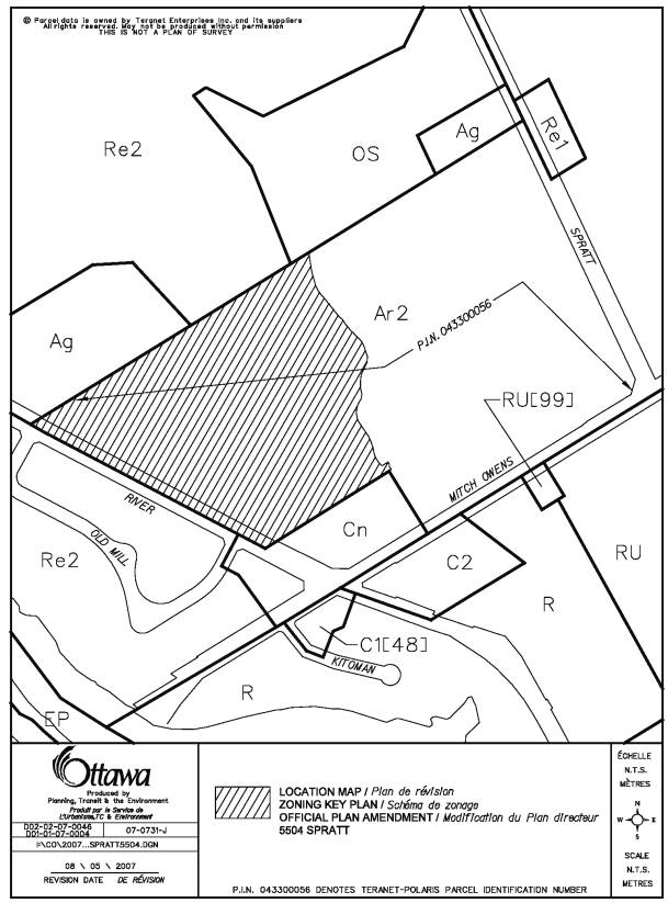
The subject lands are located on River Road approximately 100 metres north of Mitch Owens Road. The subject property is situated in proximity to, but outside the Village of Manotick.
The subject lands are surrounded to the north by residential estate lots and a 10-acre hobby farm, to the south by a Tim Horton's restaurant and a bank, to the east by a rural residence and beef farm operation fronting on Spratt Road and to the west by residential single detached dwellings. There is also a small retail plaza at the northeast corner of Bridge Street and River Road.
The lands are currently being used as pasture lands to grow hay for cattle. The lands subject to these amendments are approximately 11.13 hectares in size and will be severed from an overall holding of 26.7 hectares. The current owners plan to continue their farm operation on the retained parcel fronting on Spratt Road.
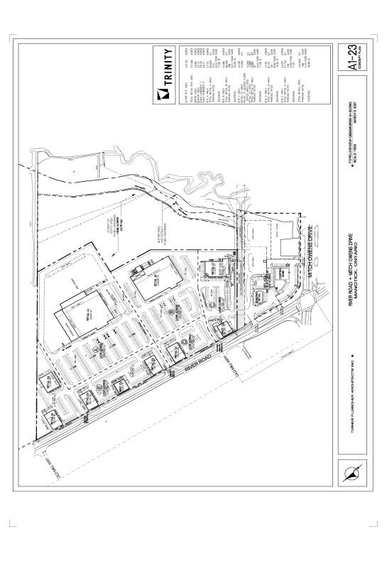
The proposal consists of approximately 13,377.6 square metres of total planned building area on 11.3 hectares of land yielding a site coverage of 18.69 per cent. The plan shows six smaller retail buildings and two restaurant pads along River Road and two large retail buildings further back on the site between the creek and River Road.
The applicant appealed both applications to the Ontario Municipal Board claiming the City failed to make a decision regarding the Official Plan Amendment within 180 days and failed to make a decision regarding the Zoning By-law Amendment within 120 days as established by the Planning Act.
The purpose of this report, therefore, is to provide the Committee with staff’s recommendation concerning the applications, and to seek Committee’s direction respecting the City’s position at the pending Ontario Municipal Board hearing concerning the appeal.
DISCUSSION
Provincial Policy Statement
The Provincial Policy Statement (PPS) stresses that development in the rural areas shall be appropriate to the infrastructure which is planned or available and shall avoid the need for the unjustified and/or uneconomical expansion of this infrastructure. Development should be compatible with the rural landscape and should be sustained by rural service levels. Locally important agricultural areas should be designated and protected by directing non-related development to areas where it will not constrain these resources.
The PPS also includes policies that require the protection of surface water and groundwater. This includes minimizing potential negative impacts on the existing watershed, identifying surface water features, ground water features, hydrologic functions and natural heritage features and areas which are necessary for the ecological and hydrological integrity of the watershed. It also suggests implementing necessary restrictions on development and site alteration to protect, improve or restore vulnerable surface and ground water and sensitive surface and ground water features, and ensuring stormwater management practices minimize stormwater volumes and contaminant loads and maintain or increase the extent of vegetative and pervious surfaces.
According to the PPS, land may be excluded from prime agricultural areas for limited non-residential uses, provided the land does not comprise a specialty crop area, there is a demonstrated need within the established planning horizon for additional land to be designated to accommodate the proposed use, there are no reasonable alternative locations which avoid prime agricultural areas, and there are no reasonable alternative locations in prime agricultural areas with lower priority agricultural lands. Impacts from any new or expanding non-agricultural uses on surrounding agricultural operations and lands should be mitigated to the extent feasible.
Official Plan
The Official Plan designates the subject lands as an Agricultural Resource Area. The purpose of this designation is to protect prime agricultural land from loss to other uses and to ensure that uses that would conflict with agricultural operations are not established in productive farming areas.
The identification of prime agricultural lands is based on the Ottawa-Carleton Land Evaluation and Area Review (LEAR) evaluation system that employs the following factors: soil capability for agriculture (large areas predominantly of soils of Classes 1, 2 and 3), land use (existing use of individual properties), parcel size (flexibility of parcel size to accommodate different farm activities) and the presence of conflicting land uses in the area (e.g. adjacent to Villages or residential uses).
Although the primary use of land in the Agricultural Resource Area is intended to be agriculture, the Official Plan permits other uses such as small-scale industrial and commercial uses that are directly related to agriculture, subject to a rezoning, on areas of poor soils that exist within the larger prime agricultural areas. These small areas of various sizes are marginally productive or of lower priority for agriculture due to their size, shape, topography, soil class, drainage, location, access or other physical characteristics. The possible permitted uses must be of the type that needs to locate close to farm operations, such as livestock assembly points, grain drying, storage for farm produce, and custom machinery operators. Furthermore, these uses must not adversely affect agricultural operations in the general vicinity.
The Official Plan also contains a comprehensive Plan for the Village of Manotick. This Plan emphasizes that the retail uses and all commercial activities should be located exclusively in the core of the village. Guiding principles for the Village are in place to ensure Manotick continues to serve as the retail and business centre of a predominantly rural community while managing its evolution as a residential community situated at the edge of a growing metropolitan area. The principles are also in place to enhance and develop the Village Core as a place of commerce to serve the Villagers and residents of the surrounding rural community. The objective of the plan is to basically ensure the Village Core continues to function as Manotick’s meeting place, its retail centre and the primary focus of its economic activity.
Requested Official Plan
Amendment
The proposal calls for an amendment to the Official Plan from an Agricultural Resource Area to a General Rural Area designation. The General Rural Area contains a variety of land uses, such as farms, rural housing, wood lots and forests, small industries, golf courses, and in many places, small clusters of residential and commercial development. The intent of this designation is to accommodate a variety of land uses that are appropriate for a rural location and a limited amount of residential development where such development will not preclude continued agricultural and non-residential uses.
This designation may allow,
subject to a rezoning, such new industrial and commercial uses as farm
equipment and supply centres, machine and truck repair shops, building products
yards, landscape contractors, and nurseries.
Other new non-residential uses that would not be better located within a
Village and which are in keeping with the rural character, or those uses that
meet the needs of the travelling public, such as a restaurant, gas station,
motel or retail use of up to 1,000 square metres gross leasable area or similar
use, would also be appropriate in this land use designation.
RATIONALE
Policies
When considering an application to amend the Zoning By-law to permit a new use, staff must determine whether or not it would be better located in a Village or the urban area, and if located on a local road, it must be demonstrated that the volume and pattern of traffic flow anticipated from the development will not interfere with the proper functioning of the local road network. The privacy of adjacent landowners and the potential adverse impacts of lighting, noise, odour, dust or traffic must be considered as well as the impact on neighbouring agricultural uses or nearby rural residential or Village communities. The development must also be in keeping with the surrounding rural character and landscape. All requirements related to transportation, servicing, design and compatibility and environmental protection must be considered. Noxious uses will not be considered in locations within groundwater recharge areas or immediately adjacent to residential areas, scenic-entry routes, or waterfront areas.
Development proposals within one kilometre of a Village and/or urban boundary must be reviewed with respect to lot size, type of use and other characteristics to ensure that they do not adversely limit potential expansion of the boundary at that location or create a long-term demand for the extension of municipal services.
The subject proposal is located within one kilometre of the Village of Manotick in an unserviced area. It is much larger than the maximum allowable 1,000-square metre floor area described in the policies. The development is of an urban scale and not in keeping with the surrounding rural character and landscape. It is adjacent to an existing farm, estate residential lots and small-scale commercial uses. In accordance with Official Plan policies, any major new retail facility of this scale in this area belongs in the Village of Manotick.
This proposal for the development of a commercial shopping centre does not comply with the intent of the Official Plan policies established to allow for small-scale commercial uses directly related to agriculture. Also, allowing this scale of commercial retail development just outside of the village limits would heavily impact the vibrancy and viability of the Manotick Village Core and would likely hinder the planned development of a commercial core in Greely.
The subject proposal does not meet the tests described in the Provincial Policy Statement because it is not compatible with the rural landscape, has not conclusively demonstrated sustainable rural servicing, would remove land from a prime agricultural area, and there are reasonable alternative locations where this use would be better suited.
Private Services
Notwithstanding the policy issues outlined above, staff reviewed the supporting documents which accompanied the Official Plan Amendment and Zoning By-law Amendment proposals and found some of the reports to be incomplete and somewhat contradictory. There were several critical elements for which staff were missing information in order to complete a comprehensive review.
The drinking water system, the stormwater management system and the sewage system information did not permit staff to clearly assess the capacity and impacts of such systems to provide adequate servicing to the site. Various other issues related to the anticipated traffic generation by the site, entrance locations and traffic signals were also identified.
Sewage
The Phase 1 ESA needed to clarify information on existing features (structures, wells, septic) within the limits of the development. Staff requested a Reasonable Use Impact Assessment to determine the type of sewage treatment system required and to ensure that Ministry of Environment requirements can be met. The 100-year flood limit had to be properly identified on the conceptual servicing plan in relation to the septic envelope. On the original submission, the septic envelope was shown encroaching within the 100-year flood limit and needed to be revised.
Stormwater
The Stormwater Management Report did not consider external drainage flowing through the site and did not establish the 100-year flood elevation.
Water
The Hydrogeological Assessment did not provide sufficient details on well testing and did not address the impact of pumping on adjacent properties.
Other Issues
A Sediment and Erosion Control Plan was requested and not provided. Some of the information requested was submitted to the City’s satisfaction in order to deem the applications complete, however, some of the above issues were still not adequately addressed.
Traffic
The applicant’s initial Transportation Impact Study did not include traffic information for the proposed Minto Mahogany Harbour development and therefore was deemed incomplete. Submitting a revised study including this information was essential in order for staff to properly assess the impact of the traffic volumes generated by both the proposed residential development in Manotick and the proposed commercial retail shopping centre. The intersection of Mitch Owens Road and River Road and the nearby bridge are already failing under existing conditions and cannot handle additional traffic volumes without major intersection modifications and bridge improvements. The City currently has no plan to improve the capacity of Bridge Street until the Strandherd/Armstrong Bridge is constructed and the effects of which are analyzed. The preliminary development plan also clearly indicates that property acquisition is required to accommodate the widening of Mitch Owens Road at this intersection.
Conclusion
After reviewing the Official Plan policies, the Provincial Policy Statement and the documents provided by the applicant in support of the applications, the Department deems this proposal not to comply with the established policies and guiding principles for commercial development in the rural area adjacent to an established village.
The proposed commercial retail shopping centre is not in keeping with the surrounding rural character and is of a scale which clearly belongs in either a Village or an urban setting.
The traffic study provided indicates that major road modifications are required to accommodate the proposed commercial retail development without knowing the full impact it will have on the community in the absence of the Strandherd/Armstrong bridge. Furthermore, there are no plans to improve the existing Bridge Street bridge, which is currently operating at capacity, and the Mitch Owens Road and River Road intersection.
Therefore, the Department recommends that the applications for an Official Plan Amendment and Zoning By-law Amendment on the subject site be refused.
RURAL IMPLICATIONS
A shopping centre of this magnitude is inconsistent with the rural character and would seriously threaten the vibrancy and viability of the Manotick Village Core as well as the planned development of a commercial core in Greely.
CONSULTATION
Notice of this application was carried out in accordance with the City's Public Notification and Consultation Policy. The Ward Councillor is aware of this application and the staff recommendation.
A Community Information Session was held on February 21, 2008 at the Manotick Public School at 1075 Bridge Street in Manotick. More than 100 residents were in attendance and most were opposed to the commercial retail proposal.
The main issues which have been raised by the residents of Manotick and surrounding areas, the business associations and community associations either at the meeting or by written submission received by the City can be summarized as follows:
1) The proposal will create an increase in noise, odour and light pollution and traffic. Congestion is already a problem at the intersection of Bridge Street/Mitch Owens and River Road. The proposed development would generate a lot of vehicular traffic because this is not a transit serviced area.
2) The development has the potential to impact the municipal drain, water table, adjacent wells and septic sewer overflow.
3) The development will have an impact on local businesses which are already struggling. The Mews Shopping Centre already has many vacant spaces and the restaurants are working hard to stay open. The main street in the heart of the village is inviting with all its local merchants. The residents want this preserved and fear that a big box retail development would destroy it.
4) The proposal is of an urban scale and belongs in Riverside South or Barrhaven, not east of the river outside of the Village.
5) River Road is part of the scenic-entry route into Ottawa and should be preserved as such without introducing this size and type of commercial development.
6) Residents chose to live in Manotick and surrounding area because of the rural nature of the area, free of large-scale commercial development. The proposed development, which would have multiple accesses and traffic signals, is not compatible with the surrounding rural low density development and community lifestyle.
7) Garbage bins, noisy delivery trucks, exhaust fumes from the restaurants and the smell of septic sewage (already a problem with the existing Tim Horton's) will negatively impact the surrounding residential homes and farms.
8) The development will have a potential impact on property values and marketability of homes in the surrounding area.
Response
to Public Comments
Staff are in agreement with most of the concerns expressed by the residents relating to the appropriateness of the subject proposal in this location. The scale of commercial development proposed is not appropriate for the rural area and would be more suitably located in the urban area or within a village, particularly when situated so close to an established village. Some of the traffic and private servicing issues remain outstanding as staff’s most recent comments have not yet been addressed by the applicant.
LEGAL/RISK MANAGEMENT
IMPLICATIONS
The
applicant has already appealed the Official Plan and Zoning amendments to the
Ontario Municipal Board on the basis that they have not been adopted within 180
and 120 days respectively of an application having been filed that meets the
minimum requirements of the Planning Act. It can therefore be anticipated that there would be a hearing on
these matters in 2009.
However,
the Ontario Municipal Board has the authority to dismiss on a motion, without
holding a hearing, an appeal where the Board is of the view that the appeal has
no planning merit. It is the opinion of
Legal Services that there is a solid justification for bringing such a motion
in this case. Should the
recommendations be adopted, staff will proceed to request a motion date from
the Board.
FINANCIAL IMPLICATIONS
N/A
APPLICATION PROCESS TIMELINE STATUS
This application was not processed by the "On Time Decision Date" established for the processing of Official Plan amendments and Zoning By-law amendments due to the complexity of issues pertaining to servicing, stormwater management and traffic.
SUPPORTING DOCUMENTATION
Document 1 Location Map
Document 2 Proposed Concept Plan
DISPOSITION
City Clerk and Legal Services Branch, Legislative Services to notify the owner, Trinity Property Holdings, 150 Isabella Street, Suite 610, Ottawa, ON K1S 1V7, applicant, Holzman Consultants Inc., 1076 Castle Hill Crescent, Ottawa, ON K2C 2A8, OttawaScene.com, 174 Colonnade Road, Unit #33, Ottawa, ON K2E 7J5, Ghislain Lamarche, Program Manager, Assessment, Financial Services Branch (Mail Code: 26-76) of City Council’s decision.
LOCATION MAP DOCUMENT 1
PROPOSED CONCEPT PLAN DOCUMENT 2