|
Plan de
conception communautaire de FERNBANK : modification au Plan officiel;
Plan directeur des transports; Plan directeur de viabilisation; et plan de
gestion environnementale |
Committee recommendations as
amended
(This matter is subject to Bill 51)
That Council:
1.
Approve the Fernbank Community Design Plan in Document 3, the
Transportation Master Plan in Document 4, the Master Servicing Plan in Document
5 and the Environmental Management Plan in Document 6, which have been
submitted under separate cover.
2. Approve Official Plan Amendment No. XX
to the City of Ottawa Official Plan (2003), as detailed in Document 2, to
implement the Community Design Plan.
3. Amend
Document 2 – Official Plan Amendment to correct an error in the legend by
deleting Schedule 2 and replacing it with a new Schedule 2.
4. Amend
Document 2 – Official Plan Amendment by deleting policy 2 vi) and replacing it
with a new policy 2 vi).
5. Amend
Document 3 – Fernbank Community Design Plan, by deleting Figure 11 – Greenspace
Plan and replacing with a new Figure 11.
6. Amend
Document 3 – Fernbank Community Design Plan, Section 6.4.3 Road Network for
Arterial Road/Transit Corridor by adding the following bullet:
·
At both Terry Fox Drive and the North-South Arterial extension
provision should be made for possible grade separation of these transportation
facilities where they intersect this potential rapid transit corridor. At the North-South Arterial there is also
the intersecting new Abbott Street extension, which makes such a grade
separation more problematic; consideration of a long-term grade separation of
these various transportation facilities at this location will be addressed as
part of the EA study being soon undertaken by the City for the Western
Transitway segment from Kanata Centrum to Fernbank Road.
7. Amend
Document 3 – Fernbank Community Design Plan, Section 6.5.4 Linkages and Pathways
by deleting the last bullet and replacing it with the following:
·
It is recommended that lands to accommodate a
grade separation of the TransCanada Trail, whose use
may in the long term include a rapid transit corridor, at the North-South
Arterial be protected for.
8. Amend
Document 3 – Fernbank Community Design Plan, Section 7.7 Affordable Housing, by
deleting the first bullet in the third paragraph and replacing it with the
following:
·
“City Council or a social housing provider may
acquire land to build social housing units equivalent to approximately 7% of
the total units anticipated”.
9. Amend
Document 3 – Fernbank Community Design Plan, Section 6.4.3 Road Network by
deleting the following bullet for Collector Roads and Local Roads:
·
Coordinate the location of trees, street fixtures, utility and light
poles, and signs.
and replacing it with the following:
·
Coordinate the location of trees, street fixtures,
telecommunications equipment, utility and light poles, and signs.
10. Amend
Document 3 – Fernbank Community Design Plan, by deleting Figure 18 –Cross
–Section for 26m Major Collector Road and replacing it with a new Figure 18 as
shown in Attachment 4.
11. Amend Document 4 – Transportation
Master Plan, Section 12.1 Plan of Roads by adding a new paragraph before the
earlier paragraph that begins with “It is also noteworthy …”, to read as
follows:
“The TransCanada Trail runs along a corridor that has been
identified in the Ottawa Official Plan and Transportation Master Plan as a
long-term (post-2031) potential rapid transit corridor both within Ottawa and
possibly beyond to communities such as Carleton Place. It is also a part of a long-term commuter
rail network referenced in the Mayor Task Force on Transportation (2007). At both Terry Fox Drive and the North-South
Arterial extension provision should be made for possible grade separation of
these transportation facilities where they intersect this potential rapid
transit corridor. At the North-South
Arterial there is also the intersecting new Abbott Street extension, which
makes such a grade separation more problematic; consideration of a long-term
grade separation of these various transportation facilities at this location
will be addressed as part of the EA study being soon undertaken by the City for
the Western Transitway segment from Kanata Centrum to Fernbank Road”.
12. Amend Document 4 – Transportation Master Plan, Section 12.2
Pedestrian and Cycling Plans by adding the following sentence at the end of the
third paragraph:
As stated in Section
12.2 the issue of potential grade separation must also be considered for this
same east-west corridor whose use may in the long term include a rapid transit
corridor.
13. Amend
Document 5, Master Servicing Study, Section 13.0 Conclusions by adding the
following as the second last bullet under Storm Drainage:
·
A local grade raise constraint affects the storm sewer west
of Terry Fox Drive between the Glen Cairn SWF and the Trans-Canada Trail. The constraint area is identified on the
Grading Plan and may lead to reduced sewer cover, sewer insulation, units
without basements, or geotechnical techniques to raise the grade such as
pre-loading or light-weight fill.
Resolution of this local constraint will be addressed at detailed design
stage in conjunction with Plans of Subdivision.
14. Amend Document 5, Master Servicing
Study, Section 13.0 Conclusions by adding the following as the last bullet
under Wastewater Collection:
· A local grade raise constraint affects the wastewater system west of the Carp River between Hazeldean Road and the Carp Tributary. The constraint area is identified on the Grading Plan and may lead to reduced sewer cover, sewer insulation, units without basements, or geotechnical techniques to raise the grade such as pre-loading or light-weight fill. Resolution of this local constraint will be addressed at detailed design stage in conjunction with Plans of Subdivision.
RecommandationS MODIFIÉES DU Comité
(Cette question est
assujettie au Règlement 51)
Que le Conseil approuve
:
1.
le Plan de conception communautaire
de Fernbank (document 3), le Plan directeur des transports
(document 4), le Plan directeur de viabilisation (document 5) et le
Plan de gestion environnementale (document 6), qui ont tous été fournis
sous pli séparé;
2.
la modification no
XX au Plan officiel de la Ville d’Ottawa (2003) selon les détails fournis dans
le document 2, dans le but de mettre en œuvre le Plan de conception
communautaire..
3. l’amendement de la modification au
Plan officiel (document 2) pour corriger l’erreur présente dans la légende,
soit le remplacement de l’Annexe 2 actuelle par la nouvelle;
4. l’amendement de la modification au
Plan officiel (document 2), soit le remplacement de la politique 2 vi) actuelle
par la nouvelle;
5. la modification du Plan de
conception communautaire de Fernbank (document 3), soit le remplacement du
schéma 11 actuel (Plan des espaces verts) par le nouveau;
6. la modification de la section 6.4.3
(Réseau routier : artères et couloirs de circulation) du Plan de conception communautaire
de Fernbank (document 3), soit
l’ajout du point suivant :
·
On prévoira une éventuelle
séparation des niveaux pour la promenade Terry Fox et le prolongement de
l’artère nord-sud aux intersections avec le couloir de transport en commun
rapide envisagé. Dans le cas de l’artère nord-sud, l’intersection avec le
nouveau prolongement de la rue Abbott rend l’aménagement d’une séparation des
niveaux problématique; on tiendra compte du projet à long terme d'aménagement
d'une séparation des niveaux pour les diverses infrastructures de transport de
ce secteur dans le cadre de l’étude d’évaluation environnementale qui sera
bientôt entreprise par la Ville pour le tronçon ouest du Transitway qui va du
centre commercial de Kanata au chemin Fernbank;
7. la modification de la section 6.5.4
(Liens et sentiers) du Plan de conception communautaire de Fernbank
(document 3), soit le remplacement du dernier point par le suivant :
·
On recommande la protection de
terres aux abords de l’artère nord-sud en prévision de l’aménagement d’une
séparation des niveaux pour le Sentier transcanadien et, à long terme, d’un
couloir de transport en commun rapide;
8. la modification de la section 7.7
(Logement abordable) du Plan de conception communautaire de Fernbank
(document 3), soit le remplacement du premier point du troisième
paragraphe par le point suivant :
·
« Le conseil municipal, ou un
fournisseur de logements sociaux, peut acquérir des terres en vue de bâtir des
unités de logement social équivalent à environ 7 % de l’ensemble des
unités prévues »;
9. la modification de la section 6.4.3
(Réseau routier) du Plan de conception communautaire de Fernbank
(document 3), en supprimant le point ci-dessous relatif aux routes
collectrices et aux routes locales :
·
Coordonner le choix de l’emplacement
des arbres, des accessoires fixes, des poteaux électriques, des lampadaires et
des panneaux de signalisation;
et en le remplaçant par le point
suivant :
·
Coordonner le choix de l’emplacement
des arbres, des accessoires fixes, des installations de télécommunications, des
poteaux électriques, des lampadaires et des panneaux de signalisation;
10. la modification du Plan de conception
communautaire de Fernbank (document 3), soit le remplacement du schéma 18
actuel (coupe transversale de 26 m de la route collectrice principale) par
le nouveau schéma (pièce jointe no 4);
11. la modification de la
section 12.1 (Plan des routes) du Plan directeur des transports (document 4),
soit l’ajout d’un nouveau paragraphe avant le paragraphe commençant par
« Il convient également de noter […] » qui se lira comme suit :
« Le Sentier transcanadien longe le couloir décrit dans le Plan
officiel de la Ville et le Plan directeur des transports comme étant, à long
terme (soit après 2031), un couloir potentiel de transport en commun rapide
pour Ottawa et, éventuellement, pour
les collectivités environnantes, comme Carleton Place. Il fait également partie
du réseau de train de banlieue envisagé à long terme par le Groupe de travail du
maire sur les transports (2007). On prévoira une éventuelle séparation des
niveaux pour la promenade Terry Fox et le prolongement de l’artère nord-sud aux
intersections avec le couloir de transport en commun rapide envisagé. Dans le
cas de l’artère nord-sud, l’intersection avec le nouveau prolongement de la rue
Abbott rend l’aménagement d’une séparation des niveaux problématique; on
tiendra compte du projet à long terme d'aménagement d'une séparation des
niveaux pour les diverses infrastructures de transport de ce secteur dans le
cadre de l’étude d’évaluation environnementale qui sera bientôt entreprise par
la Ville pour le tronçon ouest du Transitway qui va du centre commercial de
Kanata au chemin Fernbank. »
12. la modification de la section 12.2
(Plans de circulation piétonnière et cycliste) du Plan directeur des transports
(document 4), soit l'ajout de la phrase suivante à la fin du troisième
paragraphe :
Comme on l’indique à la section 12.2, la question de l’aménagement
possible d’une séparation des niveaux doit aussi être envisagée pour le couloir
est-ouest, lequel pourrait à long terme comprendre un couloir de transport en
commun rapide.
13. la modification de la
section 13.0 (Conclusions) de l’étude du Plan directeur de viabilisation
(document 5), soit l’ajout du
point suivant sous « Réseau d’évacuation des eaux pluviales » avant le dernier
point :
·
Les contraintes locales relatives à
la hausse du niveau du sol ont une influence sur les égoûts pluviaux à l’ouest
de la promenade Terry Fox entre les installations pour la régulation des eaux pluviales
de Glen Cairn et le Sentier transcanadien. Ce secteur de contraintes, dont on
traite dans le plan de nivellement, pourrait avoir une influence sur la
réduction de la couverture et de l’isolation des installations d’égoûts, la
construction d’édifices sans soubassement ou les procédés géotechniques
utilisés pour relever le niveau du sol (notamment le recours au pré-remblayage
ou à des matériaux de remblayage légers). On tentera de régler ces contraintes
locales à l’étape de la conception détaillée en tenant compte des plans de
lotissement.
14. la modification de la section 13.0 (Conclusions) de l’étude du Plan
directeur de viabilisation (document 5), soit l’ajout du point suivant sous
« Collecte des eaux usées » au dernier point :
·
Les
contraintes locales relatives à la hausse du niveau du sol ont une influence
sur le réseau de collecte des eaux usées à
l’ouest de la rivière Carp entre le chemin Hazeldean et les tributaires de la
rivière Carp. Ce secteur
de contraintes, dont on traite dans le plan de nivellement, pourrait avoir une influence sur la réduction de la couverture et de
l’isolation des installations d’égoûts, la construction d’édifices sans
soubassement ou les procédés géotechniques utilisés pour relever le niveau du
sol (notamment le recours
au pré-remblayage ou à des matériaux de remblayage légers). On tentera de régler ces contraintes locales à l’étape de la
conception détaillée en tenant compte des plans de lotissement.
Documentation
1.
Deputy
City Manager’s report, Infrastructure Services and Community Sustainability
dated 24 May 2009 (ACS2009-ICS-PLA-0079).
2.
Extract
of Draft Minute, 9 June 2009.
Report to/Rapport au :
Planning and Environment Committee
Comité de l’urbanisme et de l’environnement
and Council / et au Conseil
Submitted
by/Soumis par : Nancy Schepers, Deputy City Manager
Directrice municipale adjointe,
Infrastructure Services and Community
Sustainability
Services d’infrastructure et
Viabilité des collectivités
Contact Person/Personne-ressource : Richard
Kilstrom, Manager/Gestionnaire, Policy Development and Urban Design/Élaboration
de la politique et conception urbaine, Planning and Growth Management/Urbanisme
et Gestion de la croissance Élaboration de la politique et conception urbaine
(613)
580-2424 x22653, Richard.Kilstrom@ottawa.ca
REPORT
RECOMMENDATIONS
That the Planning and Environment Committee recommend
that Council:
1. Approve the Fernbank Community Design Plan in Document 3,
the Transportation Master Plan in Document 4, the Master Servicing Plan in
Document 5 and the Environmental Management Plan in Document 6, which have been
submitted under separate cover.
2. Approve Official Plan Amendment No. XX to the City of Ottawa
Official Plan (2003), as detailed in Document 2, to implement the Community
Design Plan.
RECOMMANDATIONS DU RAPPORT
Que le Comité de
l'urbanisme et de l'environnement recommande que le Conseil approuve :
1. le
Plan de conception communautaire de Fernbank (document 3), le Plan
directeur des transports (document 4), le Plan directeur de viabilisation
(document 5) et le Plan de gestion environnementale (document 6), qui
ont tous été fournis sous pli séparé;
2. la
modification no XX au Plan officiel de la Ville d’Ottawa (2003)
selon les détails fournis dans le document 2, dans le but de mettre en œuvre le
Plan de conception communautaire.
EXECUTIVE SUMMARY
Assumptions and Analysis:
The Fernbank Community Design Plan (CDP) is a plan for a new community
that is 674 hectares in size that will contain 9700 to 11000 dwelling units,
with an estimated population of 28000 to 31350 people and 2500 to 2650 jobs.
In August 2005, the Ontario Municipal Board allowed appeals by Del, Brookfield and West Park Estates to designate their lands between Stittsville and Kanata as urban in the 1997 Regional Official Plan. In Order 2092, the Board requested that a modification to the 1997 Plan be prepared to guide future development of the area according to policies similar to those in the 2003 Official Plan regarding community design plans. Recognizing that the designation of the area was also appealed in the 2003 Official Plan, Council subsequently settled the 2003 Plan appeals by supporting a ‘Future Urban Area’ designation for the area and setting additional requirements for the community design plan.
The purpose of a community design plan is to establish a community-wide land-use framework that reflects the principles, objectives and policies for community development as directed by the Official Plan. The CDP provides a level of detail between Official Plan policy and development approval and enables communities to establish incrementally over time in an optimum and coordinated manner. Community design plans are used as a tool to guide the preparation and review of applications for development.
The Fernbank CDP establishes the arrangement of the public road network, municipal water and stormwater management and sanitary sewer infrastructure, rapid transit corridor, the location of high, medium and low density residential areas, mixed use areas, schools, parks and open space linkages. The Plan also includes a Demonstration Plan, which illustrates one way in which the land use plan could be implemented: design guidelines providing a framework of design criteria for the overall identity and structure of the proposed Fernbank community and an Implementation Plan describing the mechanisms which will guide the administration and implementation of the CDP.
The proposed Official Plan Amendment in Document 2 is required to implement the Fernbank CDP. The Amendment makes a number of revisions to Official Plan schedules to account for the changes in land use and the transportation network required for the Fernbank community. Policies are added to Section 5.3 Implementation, requiring landowners to enter into private agreements to share and front end the costs of the major infrastructure projects and public amenities.
Three concurrent and integrated Class Environmental Assessment Studies/Master Plans were initiated to support the CDP: a Transportation Master Plan to provide for a road and transit network and a pedestrian and cycling plan; a Master Servicing Plan for water, storm drainage and sanitary services; and an Environmental Management Plan (EMP) for the natural environment and stormwater management/outlets. These reports have been prepared in conjunction with the community design plan for lands within the study area of the Fernbank Community.
This report seeks approval of the Fernbank CDP, the Transportation Master Plan, the Master Servicing Plan, the Environmental Management Plan and the Official Plan Amendment required to implement the Fernbank CDP.
Legal/Risk Management Implications:
The Fernbank Community Design Plan has been prepared using an integrated planning and environmental assessment process. The Official Plan Amendment is required to implement the Fernbank CDP. The Transportation Master Plan, Master Servicing Study, and Environmental Management Plan were prepared in accordance with the Planning Act provision of the Municipal Engineers Association Environmental Assessment Process. As such, the Official Plan amendment, Transportation Master Plan; a Master Servicing Study; and an Environmental Management Plan are subject to all normal notice requirements and rights of appeal by any person or public body to the Ontario Municipal Board under the provisions of the Planning Act. As this has been done through the integrated process, the notice of adoption will reflect that approval under the Environmental Assessment Act is being sought and there will not be a separate process for Part II Order ("bump up") requests.
If no notice of appeal is filed and the time for filing an appeal has expired, Council’s decision to adopt the amendment and infrastructure master plans will be final and the portion of the Official Plan and the Master Plans that has been amended will come into effect on the day after the last day for filing a notice of appeal.
Enactment of this Official Plan Amendment, Transportation Master Plan; a Master Servicing Study; and an Environmental Management Plan will enable Council to implement the Fernbank Community Design Plan.
Financial Implications:
Development Charges
Development of major servicing infrastructure, parks and recreational trails within Fernbank will be financed as per the Development Charges By-law.
Cost Sharing/Front-End Agreements
As development proceeds within the Fernbank Community Design Plan, innovative implementation strategies will be required in order to ensure the timely advancement of municipal infrastructure and community amenities and facilities. A cost sharing/front end agreement will be established within the Fernbank community to provide for landowners who wish to front-end and share the costs contemplated in the development of major spine infrastructure (roads, sewer and water) and public amenities, and in doing so, front end for those benefiting landowners who choose not to participate in the upfront funding of the costs contemplated in a comprehensive cost sharing agreement that addresses community land and shared infrastructure principles.
There will also be a master parkland agreement established within the Fernbank community to create a mechanism, which allows for compensation of parkland dedication that may be inequitably distributed across the Fernbank CDP.
New Infrastructure: Water, Wastewater, Stormwater Management and Drainage Servicing:
The build-out of this area will ultimately result in the City’s acquisition of the following new infrastructure:
- Watermains: approx. 76 kilometres
- Sanitary sewers: approx. 76 kilometres
- Storm sewers: approx. 76 kilometres
- Stormwater management ponds: eight wet ponds and five dry ponds
- Rehabilitated upper reach of the Monahan Drain: 800 metres
The number of stormwater management ponds is a function of the preservation of the Carp River West Tributary and the rehabilitation of the upper reach of the Monahan Drain, as well as the existing drainage divides within the development area that require the maintenance of flows to existing subwatersheds.
Requisite funding will be required for operation and maintenance as the City gradually assumes this new infrastructure over time. It is anticipated that the development will reach full build-out in approximately 20 years.
At build-out, the estimated annual operation and maintenance costs, in 2009 dollars, for the Fernbank community will be:
Watermains: approx. 76 kilometres $540,000 (7,100 $/km/year)
Sanitary sewers: approx. 76 kilometres $365,000 (4,800 $/km/year)
Storm sewers: approx. 76 kilometres $220,000 (2,900 $/km/year)
Stormwater management: $550,000 (ponds and channel maintenance)
These estimated annual costs represent approximately 0.7 per cent of the total annual operational budget for these services and will be recovered through the water and sewer rate.
Requisite
funding will also be required for operation and maintenance the new
transportation infrastructure as the City gradually assumes infrastructure that
will be built over time (rapid transit, arterial and collector roads, local
streets and sidewalks.
Woodlot
Acquisition
The moderate-value woodlot is designated as Urban Natural Feature in the Official Plan, which necessitates its acquisition by the City. This acquisition will be the subject of a future report.
Should acquisition not be possible, then an Official Plan Amendment will be required to permit development. Such development will be consistent with the underlying Low Density Residential designation in the Fernbank CDP.
Parks
– Land Banking and Compensation
Prior to the approval of the first plan of subdivision within the CDP area, an agreement will be executed among the landowners to establish a mechanism that allows for the compensation of parkland that may be inequitably distributed across ownership throughout the entire CDP. For the purposes of implementing the Fernbank Community Design Plan, the City will track all revenues and expenditures generated within this growth area. In order to preserve the integrity of the fund, cash-in lieu revenues generated in the Fernbank Community will be spent in Fernbank Community up to final build-out within the CDP planning area.
Public Consultation/Input:
Consultation is an integral part of both the Planning and Class
Environmental Assessment process. Consultation and the exchange of information
was undertaken throughout the assessments using a variety of methods including
meetings with community associations and the general public, electronic
information distribution and regular meetings with the study team, approval
agencies, and the three Ward Councillors.
Five public open houses were held at key junctures in the Fernbank study to develop the plan. The last meeting was held on April 27, 2009 to present the proposed CDP, Master Servicing Study, Environmental Management Plan, Transportation Master Plan and Official Plan Amendment.
RÉSUMÉ
Hypothèses et analyse
Le Plan de conception communautaire (PCC) de
Fernbank vise à établir cette nouvelle communauté de 674 hectares qui
comportera entre 9 700 et 11 000 unités d’habitation et qui, selon
les estimations, comptera une population d’entre 28 000 et 31 350
habitants et entre 2 500 et 2 650 emplois.
En août 2005, la Commission des affaires
municipales de l’Ontario a accueilli des appels des domaines résidentiels de
Del, de Brookfield et de West Park visant à obtenir le zonage urbain de leur
territoire situé entre Stittsville et Kanata dans le Plan directeur régional
de 1997. Dans l’Arrêté 2092, la Commission a exigé qu’une modification
soit apportée au Plan directeur de 1997 afin que les projets d’aménagement à
venir soient menés selon des politiques semblables à celles du Plan officiel de
2003 en matière de conception communautaire. Puisque la désignation du
territoire a aussi fait l’objet d’appels pour ce qui est du Plan officiel de
2003, la Commission a décidé de donner son appui à une désignation de
« future zone urbaine » pour le territoire en question et a établi
d’autres exigences relatives au plan de conception communautaire.
L’objectif d’un plan de conception
communautaire est d’établir un cadre d’utilisation du sol applicable à
l’ensemble de la communauté qui reflète les principes, les objectifs et les
politiques du Plan officiel en matière de développement communautaire. Le PCC
fournit un niveau de détail se situant à mi-chemin entre les politiques du Plan
officiel et les documents d’approbation des projets d’aménagement et permet aux
communautés de s’établir progressivement d’une façon coordonnée et optimale.
Les plans de conception communautaire sont utilisés pour guider la préparation
et l’examen des demandes d’aménagement.
Le PCC de Fernbank définit la configuration du
réseau routier, les infrastructures pour l’approvisionnement en eau potable et
pour la gestion des eaux usées domestiques et des eaux pluviales, le corridor
de transport en commun rapide, ainsi que l’emplacement des zones résidentielles
à forte, à moyenne ou à faible densité, des zones polyvalentes, des écoles, des
parcs et des espaces ouverts. Le PCC comprend également un plan de
visualisation, qui illustre une façon d’appliquer le plan d’utilisation du sol.
Il s’agit de lignes directrices qui constituent un cadre de conception
englobant la structure et l’identité générales proposées de la communauté de
Fernbank, de même qu’un plan de mise en œuvre qui décrit les mécanismes selon
lesquels le PCC sera administré et réalisé.
La modification au Plan officiel proposée dans
le document 2 est requise pour mettre en œuvre le PCC de Fernbank. Cette
modification apporte plusieurs corrections aux annexes du Plan officiel afin de
tenir compte des changements quant à l’utilisation du sol et des besoins de la
communauté de Fernbank en matière de transports. De plus, des politiques ont
été ajoutées à la section 5.3 intitulée « Mise en œuvre » pour que
les propriétaires de terrain concluent des ententes privées pour financer à
l’avance une partie des coûts des commodités publiques et des grands projets
d’infrastructures.
Trois évaluations environnementales de portée
générale/plans directeurs intégrés ont été amorcés pour appuyer le PCC :
le Plan directeur des transports, qui concerne le réseau routier, le transport
en commun, les cyclistes et les piétons; le Plan directeur de viabilisation,
qui touche l’approvisionnement en eau, l’évacuation des eaux pluviales et la
gestion des eaux usées; et le Plan de gestion environnementale (PGE), qui porte
sur les zones écologiques naturelles et les exutoires d’eaux pluviales. Ces
documents ont été préparés dans le cadre de l’élaboration du PCC pour les terres
comprises dans la zone à l’étude de la communauté de Fernbank.
Le présent rapport vise l’approbation du PCC de
Fernbank, du Plan directeur des transports, du Plan directeur de viabilisation,
du Plan de gestion environnementale et de la modification au Plan officiel qui
est requise pour mettre en œuvre le PCC de Fernbank.
Incidence sur le plan juridique et
de la gestion des risques
Le Plan de conception communautaire de Fernbank
a été préparé à l’aide d’un processus intégré d’aménagement du territoire et
d’évaluation environnementale. La modification au Plan officiel est nécessaire
pour mettre en œuvre le PCC de Fernbank. Le Plan directeur des transports, le
Plan directeur de viabilisation et le Plan de gestion environnementale ont été
élaborés conformément à la disposition portant sur la Loi sur l'aménagement du territoire du document Environmental Assessment Process de la
Municipal Engineers Association. Ainsi, la modification au Plan officiel, le
Plan directeur des transports, le Plan directeur de viabilisation et le Plan de
gestion environnementale sont assujettis à toutes les exigences en matière
d’avis et à tous les droits d’appel par toute personne ou organisme public
auprès de la Commission des affaires municipales de l’Ontario, en vertu des
dispositions de la Loi sur l'aménagement
du territoire. En raison du processus intégré, l’avis d’adoption indiquera
que l’on cherche à obtenir une approbation en vertu de la Loi sur les évaluations environnementales, et aucun autre processus
ne sera requis pour les demandes d’Arrêté de la partie II.
Si aucun avis d’appel n’est déposé et que la période
d’appel est expirée, la décision du Conseil d’adopter la modification et les
plans directeurs de l’infrastructure sera définitive, et la partie du Plan officiel
et des plans directeurs qui a été modifiée entrera en vigueur le lendemain du
dernier jour pour déposer un avis d’appel.
L’adoption de la modification au Plan officiel,
du Plan directeur des transports, du Plan directeur de viabilisation et du Plan
de gestion environnementale permettra au Conseil de mettre en œuvre le Plan de
conception communautaire de Fernbank.
Incidence financière
Redevances d’aménagement
Les aménagements importants de parcs, de
sentiers récréatifs et d’infrastructures de viabilisation seront financés en
vertu du Règlement sur les redevances d’aménagement.
Ententes de paiement à
l’avance et de partage des coûts
Dès le début des travaux prévus dans le Plan de
conception communautaire de Fernbank, des stratégies de mise en œuvre
innovatrices seront requises pour assurer la progression selon l’échéancier de
l’aménagement des infrastructures municipales et des commodités et
installations communautaires. Une entente de paiement à l’avance et de partage
des coûts sera établie et permettra aux propriétaires de terrain de la
communauté de Fernbank d’assumer à l’avance une partie des coûts liés à
l’aménagement d’infrastructures centrales (routes, égouts, eau potable) et de
commodités publiques, et ainsi de compenser pour les propriétaires qui
bénéficient de ces services, mais qui choisissent de ne pas participer au
financement initial des coûts prévus dans le cadre d’une entente détaillée de
partage des coûts élaborée selon les principes de la vie en communauté.
La communauté de Fernbank se dotera également
d’une entente-cadre sur les parcs afin de créer un mécanisme d’indemnisation au
cas où la distribution des terrains réservés à la création de parcs prévue dans
le PCC de Fernbank s’avérerait inéquitable.
Nouvelles infrastructures : eau potable,
eaux usées, gestion des eaux pluviales et drainage.
Lorsque le secteur sera entièrement aménagé, la
Ville fera l’acquisition des nouvelles infrastructures suivantes :
- Conduites
d’eau principales : environ 76 kilomètres;
- Égouts
domestiques : environ 76 kilomètres;
- Égouts
pluviaux : environ 76 kilomètres;
- Bassins
de rétention des eaux pluviales : 8 étangs humides et
5 étangs secs;
- Tronçon
réparé en amont de l’installation de drainage Monahan : 800 mètres.
Le nombre de bassins de rétention des eaux
pluviales dépend de la préservation de l’affluent ouest de la rivière
Carp, de la remise en état du tronçon en amont de l’installation de drainage
Monahan et des lignes actuelles de partage des eaux à l’intérieur de la zone
d’aménagement qui requièrent un maintien de l’écoulement jusque dans les
sous-bassins hydrographiques existants.
Un financement adéquat devra être obtenu pour
le fonctionnement et l’entretien des nouvelles infrastructures au fur et à
mesure que la Ville en assumera la gestion. Selon les prévisions, le secteur
devrait être totalement aménagé dans environ 20 ans.
En situation d’aménagement maximal, les coûts
de fonctionnement et d’entretien annuels en dollars de 2009 pour la communauté
de Fernbank s’élèveront à :
Conduites d’eau principales, environ
76 km : 540 000 $
(7 100 $/km/année)
Égouts domestiques, environ 76
km : 365 000 $
(4 800 $/km/année)
Égouts pluviaux, environ 76
km : 220 000 $
(2 900 $/km/année)
Gestion
des eaux pluviales : 550 000 $
(entretien des étangs et canaux)
Ces coûts annuels estimatifs représentent
environ 0,7 % du budget de fonctionnement annuel total pour ces services
et seront recouvrés à même les redevances d’eau et d’égouts.
Un financement adéquat devra également être
obtenu pour le fonctionnement et l’entretien des nouvelles infrastructures de
transport, au fur et à mesure que la Ville assumera la gestion de ces
infrastructures qui seront construites au fil du temps (transport en commun
rapide, artères et routes collectrices, rues et trottoirs).
Acquisition du boisé
Le boisé de valeur moyenne a été désigné
« Caractéristique naturelle urbaine » dans le Plan officiel, ce qui
signifie que la Ville doit en faire l’acquisition. Ces acquisitions feront
l’objet d’un autre rapport.
Si l’acquisition s’avère impossible, il faudra
alors apporter une modification au Plan officiel afin de permettre
l’aménagement. Cet aménagement correspond à la désignation résidentielle de
faible densité dans le PCC de Fernbank.
Parcs – Réserve et
indemnisation foncières
Avant l’approbation du premier plan de
lotissement du territoire couvert dans le PCC, une entente sera établie pour
permettre aux propriétaires de terrain de bénéficier d’un mécanisme
d’indemnisation pour pallier l’iniquité éventuelle de la distribution des parcs
sur l’ensemble du territoire résidentiel concerné dans le PCC. Aux fins de la
mise en œuvre du Plan de conception communautaire de Fernbank, la Ville fera le
suivi de toutes les recettes et les dépenses générées sur le territoire
aménagé. Pour préserver l’intégrité du fonds, on s’assurera que les recettes
compensatoires générées dans la communauté de Fernbank seront utilisées dans la
communauté de Fernbank jusqu’à l’aménagement complet de la zone prévue dans le
PCC.
Consultation publique et suggestions
Les consultations font partie intégrante des
processus d’aménagement et d’évaluation environnementale de portée générale.
Tout au long des processus d’évaluation ont eu lieu des échanges d’information
et des consultations de différentes natures, y compris des rencontres avec les
associations communautaires et la population, la diffusion de renseignements
électroniques, ainsi que des réunions régulières avec le groupe d’étude, les
agences d’approbation et les trois conseillers de quartier.
On a tenu cinq séances portes ouvertes sur des
points essentiels du projet de Fernbank dans le but d’élaborer le plan. La
dernière de ces séances, qui a eu lieu le 27 avril 2009, visait à présenter le
PCC, le Plan directeur de viabilisation, le Plan de gestion environnementale,
le Plan directeur des transports et la modification au Plan officiel qui sont
proposés.
BACKGROUND
In August 2005, the Ontario Municipal Board (OMB) allowed appeals by Del, Brookfield and West Park Estates to designate their lands between Stittsville and Kanata as urban in the 1997 Regional Official Plan. In Order 2092, the Board requested that a modification to the 1997 Plan be prepared to guide future development of the area according to policies similar to those in the 2003 Official Plan regarding community design plans. Recognizing that the designation of the area was also appealed in the 2003 Official Plan, Council subsequently settled the 2003 Plan appeals by supporting a Future Urban designation for the area and setting additional requirements for the preparation of a community design plan.
The purpose of a Community Design Plan (CDP) is to establish a community-wide land use framework that reflects the principles, objectives and policies for community development as directed by the Official Plan. The CDP provides a level of detail in-between Official Plan policy and development approval and enables communities to establish incrementally over time in an optimum and coordinated manner. Community Design Plans are used as a tool to guide the preparation and review of applications for development.
Direction from Council
The Official Plan policies for Future Urban Area (Section 3.11) are as follows:
1. Council has designated a ‘Future Urban Area’ on Schedules A and B in the West Urban Centre, which is subject to the following policies:
a) Lands in the ‘Future Urban Area’ designation are subject to the ‘Developing Community’ policies of this Plan;
b) A Community Design Plan will be prepared which, in addition to the requirements for such plans in Section 3.6.4, also addresses:
i. The phasing of north-south arterial road capacity,
ii. The need to advance the timing of infrastructure identified in Council’s master plans,
iii. Provision of recreation and other public amenities,
iv. The use of front-end financing, and
v. Measures to ensure that existing local infrastructure is not overburdened;
vi. Any phasing plan should acknowledge the relationship between development timing and amount and front-end financing requirements.
c) For the purpose of estimating the urban land supply for the comprehensive review in Policy 2.2.1.3, the ‘Future Urban Area’ will be considered as vacant urban land with a General Urban designation;
d) Subject to Policy 3.11b) above, all uses permitted in the ‘General Urban’ designation shall be permitted on lands designated ‘Future Urban Area’. However, Council shall only be required to consider applications for zoning by-law amendments or draft approval of plans of subdivision on land within the ‘Future Urban Area’ on the earlier of either:
i. March 1, 2008; or
ii. The date that Council, subsequent to 9 November 2005, approves an amendment to the Plan that results in a net increase in the area of land designated for urban purposes, greater than the area designated for urban purposes on 9 November 2005.
At Council’s meeting of November 9, 2005, further direction for the preparation of the Fernbank CDP was established, including:
- Preparation in accordance with the ‘Developing Community Policies’ of the 2003 Ottawa Official Plan;
- Examination of the timely advancement of public amenities such as sports fields, parks, pathways and other amenities, including community centres, to ensure local recreational and community infrastructure is not overburdened by the development of these lands and consider front-end financing to advance the undertaking of such public amenities;
- Examination of the need for the timely advancement of other infrastructure requirements as currently defined in the Transportation Master Plan (e.g., east-west transportation linkages) and the Infrastructure Master Plan (e.g., servicing) to ensure local infrastructure is not overburden by the development of these lands and consider front-end financing to advance the undertaking of such works;
- Reflection of the alignment/design/phasing of the north-south minor arterial road in the Kanata West Concept Plan;
- Ensuring that local road infrastructure serving a function which would also be served by the new north-south arterial should not be over-burdened by the development of these lands;
- Acknowledgement that the construction of the north-south arterial is an integral part of the overall development of the Fernbank lands;
- Inclusion of a final phasing plan that acknowledges the relationship between development timing, amount and front-end financing;
- Being subject to such Environmental Assessment or Class Environmental Assessment, as may be necessary; and,
- Being subject also to any other required implementation instruments such as a new or revised Development Charges By-law.
Planning and Environment Committee approved the Terms of Reference for the Fernbank Community Design Plan on July 11, 2006. (ACS2006-PGM-POL-0062).
The Planning Team
A consultant team on behalf of the sponsoring landowners, Del Corporation, Brookfield Homes Limited and Monarch/Cardel, prepared the Fernbank CDP and Infrastructure Master Plans. The consultant team included:
- Walker, Nott, Dragicevic Associates Limited – responsible for the Community Design Plan and project coordination
- Delcan – responsible for the Transportation Master Plan and Environmental Assessment Process
- Novatech Engineering – responsible for the Master Servicing Study and Environmental Management Plan
Other consultants were hired on sub-contracts to provide additional expertise as required by the consultant team.
The project proceeded under the direction of the City of Ottawa and benefited from the direct involvement and guidance of:
· a Core Project Team (CPT) consisting of City staff and Councillors, Sponsoring Landowners and the consultants in a variety of disciplines;
· a Technical Advisory Committee (TAC) consisting of representatives from select government agencies and approval bodies;
· a Public Advisory Committee (PAC) consisting of representatives from directly affected community associations and interested community groups; and
· Government Review Agencies (GRA) who represent government agencies who administer specific permits and approvals.
· five community meetings to get public input.
Integrated Planning and Environmental Assessment Process
The Official Plan requires the completion of a community design plan for lands subject to the ‘Future Urban Area’ designation prior to any development being approved within the area. Community design plans are intended to translate the direction and policies of the Official Plan to the community level. They are comprehensive in nature, and incorporate the planning policy context (as established by the Official Plan), infrastructure servicing, transportation, environmental and economic impacts. Principles, policies and guidelines established in the CDP provide the direction required for the preparation and review of development applications within the community.
Three concurrent and integrated Class Environmental Assessment Studies/Master Plans were initiated: a Transportation Master Plan to provide for a road and transit network and a pedestrian and cycling plan; a Master Servicing Study for water, storm drainage and sanitary services; and an Environmental Management Plan (EMP) for the natural environment, development constraints and stormwater management/outlets. These reports have been prepared in conjunction with the CDP for lands within the study area of the Fernbank Community. Approval of the CDP, and subsequent development applications under the Planning Act, will be supported by these Class Environmental Assessments/Master Plans. The three Master Plans were prepared that followed integration with the Planning Act provision of the requirements of the Municipal Class Environmental Assessment (Section A.2.9) process. As such, these projects will have satisfied the requirements outlined in Section A.2.9 of the Class EA process and will require no additional EA approvals. This allows the integration of both planning processes while ensuring the intent and requirements of both Acts are met.
This process was outlined, reviewed and accepted in the Terms of Reference for the Fernbank CDP (July 2006) in consultation with the City of Ottawa and approval agencies (Rideau Valley Conservation Area, Mississippi Valley Conservation Area, Ministry of the Environment, Ministry of Natural Resources).
Study Area
The Fernbank community is located adjacent to the established communities of Stittsville to the west, Kanata West to the north and Glencairn to the east. The study area extends from Hazeldean Road on the north, the Carp River and Terry Fox Drive on the east, Fernbank Road to the south and, the existing Urban Area of Stittsville on the west, as shown on Document 1.
The study area for the CDP encompasses approximately 674 hectares. Approximately 455 hectares are designated ‘Future Urban Area’ (as per the OMB decision). The remaining lands include approximately 132 hectares designated as ‘Agriculture Resource Area’ in the northeast portion of the study area that are now entirely surrounded by urban land, and approximately 60 hectares in the southwest portion of the study area that are designated as ‘General Rural Area’. Inclusion of these rural lands in the study area for the community design plan allows for efficient planning of public services for the long term. The Fernbank CDP was prepared anticipating that these rural lands outside the ‘Future Urban Area’ designation will eventually be developed for urban purposes. The CDP and the infrastructure required to support the CDP provide for the eventual coordination and integration of these lands into the ‘Urban Area’.
Amendment 76, to be adopted by Council
on June 10, 2009 designates the rural areas wholly within the boundaries of the
Fernbank Community Design Plan as
‘Future Urban Area’ (consistent with the remainder of the Fernbank
Community Design Plan lands) in order that they be recognized as an ‘Urban
Area’ and part of the community design plan process.
Approval
This report seeks approval of the Fernbank CDP, the Transportation Master Plan, the Servicing Master Plan, the Environmental Management Plan and an Official Plan Amendment required to implement the CDP.
DISCUSSION
The planning of the future Fernbank community requires the development to be integrated with the Stittsville community to the West, the Glencairn community to the east and the Kanata West area to the north. The Fernbank CDP process provided a number of opportunities for the residents of Ottawa, including the immediate surrounding communities of Kanata South, Stittsville and Kanata West, to contribute to a collaborative community design process.
The Fernbank CDP commenced in 2006. There were a number of milestones for the development of the Plan:
- July 11, 2006 – terms of reference approved by Planning and Environment Committee
·
November 29, 2006 – Community open house – visioning
workshop
·
January 31, 2007 – Community workshop to develop the plan
·
June 5, 2007 – Community workshop – review five
Preliminary Land Use Concepts.
- September 24, 2007 – Public open house to obtain comments on the Preferred Land Use Concepts that were developed and the infrastructure supporting the proposed land uses.
·
April 27, 2009 – Public open house to solicit
comments on the recommended draft plan that was developed and the
infrastructure supporting the proposed land uses.
- May 27, 2009 – Council approved The Third Party Review of the Carp River Restoration. The Fernbank Community Design Plan process was delayed until the Third Party Review was completed as approximately one third of the Fernbank site drains into the Carp River and the results of the Review were required to determine the flow requirements from the Fernbank Community.
The Fernbank CDP process has resulted in the preparation of a Community Design Plan, a Transportation Master Plan, a Master Servicing Study, an Environmental Management Plan and an Official Plan Amendment, which are described below.
1. Community Design Plan
The Community Design Plan was developed based on consideration of the current conditions of the study areas, servicing and transportation elements, the policies of the Official Plan, and through a comprehensive community consultation process consisting of several workshops and public meetings. The CDP consists of a land use plan and policies, community design guidelines, and recommended implementation tools. The recommended Fernbank CDP reflects an urban community containing a population of approximately 28027 to 31351 residents, with approximately 9718 to 10977 dwelling units and 2497 to 2623 jobs.
A) Guiding Principles
The guiding principles for the Fernbank CDP were prepared through a consultative process involving the Core Project Team, Technical Advisory Committee, Public Advisory Committee, and the public at-large. The guiding principles represent value statements about the kind of urban environment that is desired for the community, supported by the City Council approved 2003 Official Plan and Ottawa 2020, and are listed below.
- Maintain and respect the integrity and unique character of
existing communities
New development should be sensitive and responsive to the existing communities of Stittsville and Kanata, in terms of the relationship of planned land uses, roads, open spaces, schools and recreational facilities. It is important that the character and qualities of these existing communities are not diminished by development within the Fernbank area.
- Create distinctive liveable neighbourhoods
The Fernbank community will be designed to create unique residential neighbourhoods that serve the needs of residents of different lifestyles and incomes. Therefore, residential neighbourhoods should provide a range of housing options (both opportunities for different housing types [single, semis, townhouse and apartments] as well as affordable and market rental and ownership tenures). Neighbourhoods should contain focal points, such as recreation facilities, schools, parks and green spaces, accessible to neighbourhood residents, which will serve as distinctive local landmarks and gathering places.
- Create integrated, clean and active green spaces
The Carp River and other significant natural heritage features will be protected within the Fernbank community and provide important contributions to the greenspace network. Not only do these green spaces have environmental value, they can also provide open space and active/passive recreational amenities and will contribute to a healthy community. Where appropriate, these green spaces should be linked by multi-use pathways, stormwater management facilities, and parks.
- Create a ‘heart’ for the community
The community should be designed around an identifiable focal point, which includes uses that attract and are accessible to all residents and provide a ‘sense of place’. In addition, each neighbourhood should have a local focal point (such as a park, school or other open space) so that these amenities are well distributed through the community and are easily accessible to residents.
- Provide effective, efficient, timely
transportation that is integrated with land uses
The Fernbank community should be designed to accommodate all modes of transportation within a development pattern that emphasizes walking, cycling and transit over automobile travel. A modified grid road system, with a high degree of permeability and accessibility throughout the community, will support a diverse range of land uses and modes of transportation. Roads should link to important roads around the community and more importantly, to a road, that allows through traffic to bypass Stittsville Main Street. Public transit (including rapid transit) will be extended to support and serve the community. Transportation infrastructure should proceed in concert with development and opportunities for alternative means of financing such infrastructure will be considered.
- Ensure efficient and timely phasing of future infrastructure
The effective use of existing, and the provision of new servicing infrastructure, will be employed in order that development in the Fernbank community achieves the efficient and optimal use of such facilities. Alternative development standards will be considered where such standards can achieve a quality community while maintaining appropriate operating and maintenance standards. Servicing infrastructure should proceed in concert with development and opportunities for alternative means of financing such infrastructure will be considered.
- Create an environmentally sustainable community
Development within the Fernbank community will promote pedestrian, cycling and transit usage in order to reduce energy consumption patterns associated with automobile travel. Appropriate alternative development and green building standards which support energy efficiency and environmental sustainability will be encouraged.
B) Components of the CDP
Seven key components of the CDP include:
1. Introduction:
Presents a summary of the integrated planning process and consultation process for the CDP.
2. Planning Context:
Provides a general overview of existing conditions and the policy framework for the planning of the Fernbank community and the parameters which formed the development of the Community Design Plan.
3. Development of the Plan:
Describes the guiding principles that form the basis of the CDP and provides a synopsis of the evolution of the Fernbank Community Design Plan.
4. Fernbank Community Plan:
Establishes the foundation of the Fernbank Community Design Plan. The land use plan includes seven general land use categories:
- Low Density Residential
- Medium Density Residential
- High Density Residential
- Mixed Use
- Neighbourhood Commercial
- Elementary and Secondary Schools site
- Open Space (including parkland, Natural Environment Area, Woodlot, stormwater management facilities, Village Green, hydro transmission corridors).
5. Demonstration Plan:
Illustrates a way in which the Land Use Plan could be implemented through development approvals.
6. Community Design Guidelines:
Provides a framework for the overall design, identity and structure of the proposed Fernbank Community.
7. Implementation:
Describes the mechanisms, which will guide the administration and implementation of the Fernbank CDP, including a front ending/cost sharing agreement for the provision of infrastructure and community amenities.
C) Key Features of the Plan:
The Fernbank Community Design Plan is a plan for a new community that is 674 hectares in size that will contain 9700 to 11000 dwelling units, with an estimated population of 28000 to 31350 people and 2500 to 2650 jobs. The land use plan and the demonstration plan provide a blueprint for how the Fernbank community will develop in the future. The Fernbank community is, to some extent, partitioned into three segments by the existing hydro corridors and proposed north-south arterial road (the northeast, southeast and southwest sectors). The distribution of land uses, particularly community amenities such as parks and schools, is intended to provide an equitable distribution of uses so that all areas of the community have access to such uses and facilities. An integrated road, pedestrian walkway and multi-purpose pathway network serves to connect the various sectors and land uses. The components of the land use plan are described below.
Residential:
The high, medium, and low-density land use categories will permit a range and type of residential uses and built-form. Multiple unit dwellings are dispersed throughout the planning area, but focused along arterial roads, at the intersections of collector roads within neighbourhoods, and adjacent to neighbourhood focal points and major park facilities. The High Density Residential area permits multiple attached dwellings (such as a range of street, back-to-back and stacked townhouses) low and mid-rise apartment dwellings, live-work units, rooming houses and shelter accommodation. The Medium Density Residential area includes multiple attached dwellings, triplexes, stacked dwellings, live-work units, low and mid-rise apartment dwellings, live-work units, rooming houses and shelter accommodation. The Low Density Residential area provides for single-detached, semi-detached and linked detached dwellings.
Community
Core:
A ‘center’ or ‘heart’ is an important community-defining element of the plan and accordingly, the intersection of the proposed north-south arterial road and Abbott Street/TransCanada Trail was identified as a central area. In this location, a variety of land uses (such as mixed use areas, secondary school, and higher density residential uses) in proximity to the transit station, have been provided to create an active, interesting and diverse ‘Community Core’. The village green located at the centre of the Community Core is intended to be a civic gathering place and passive public open space for residents.
Mixed Use:
The Mixed Use designation is intended to accommodate a mix of residential and non-residential land uses to serve the personal and commercial needs of the Fernbank community’s residents. The design and built-form of this area will advance a human-scale pedestrian-friendly environment. Uses permitted with the Mixed Use designation along Hazeldean Road may be oriented to commercial uses in recognition of the planned land uses on the north side of Hazeldean Road. However, residential uses are also encouraged.
Neighbourhood Commercial:
One Neighbourhood Commercial designation, approximately 8.0 hectares in size, located at the northwest corner of Terry Fox Drive and Fernbank Road, will provide neighbourhood commercial uses to the southeast sector of the community. Uses permitted within the Neighbourhood Commercial designation include convenience stores; personal service businesses; banks or other financial services; business, medical and professional offices; restaurants; and retail stores.
Schools:
The Fernbank community will accommodate up to three secondary schools and eight elementary schools, as requested by the four area school boards. The location and size of these school sites have been conceptually illustrated on the Land Use Plan and reflect the general locational and site design criteria of the respective school boards.
School sites shall be zoned for both institutional and residential use in order that, in the event that a the school board does not wish to acquire a school site established in a Plan of Subdivision, the lands shall be developed for residential land uses.
Greenspace Network:
The greenspace network is comprised of open space, parks, woodlots, stormwater management facilities, pathways and other linkages. The Official Plan identifies a target of total public greenspace of 4.0 hectares per 1000 population, or approximately 16-20 per cent of gross land area (including stormwater management facilities, pathways, schools, parks, natural heritage areas, the majority of the hydro transmission corridors, etc.). The Demonstration Plan illustrates the means by which this Official Plan target for greenspace could be achieved.
Open Space:
The Carp River and other significant natural heritage features will be protected within the Fernbank community and provide important contributions to the greenspace network. Not only do these green spaces have environmental value, they can also provide open space and safe active/passive recreational amenities and will contribute to a healthy community. The existing watercourses and drainage corridors, floodplains associated with existing watercourses, woodlot(s), hydro transmission corridors, and the TransCanada Trail provide initial structuring elements to an open space network within the Fernbank community. These elements will be augmented by and integrated with, additional open spaces in the form of parks and stormwater management facilities in order that a full range of active and passive recreational opportunities such as sports fields, play areas, passive leisure areas, pathways, and recreation facilities can be accommodated.
Woodlot:
The woodlots within the Fernbank study area were evaluated using the methodology in the Urban Natural Areas Environmental Evaluation Study (UNAEES). One woodlot located east of Shea Road/Hydro One Corridor rated moderate under the UNAEES, meeting the criteria to be designated as an ‘Urban Natural Feature’ in the Official Plan. The intent of the ‘Urban Natural Feature’ designation is to retain the woodlot in its natural state. Only passive recreation activities such as trails and orientation areas will be permitted. It is anticipated that the City will reach agreement with the owner to acquire the woodlot. However, if the City does not acquire the woodlot, an Official Plan amendment will be required to permit development. Such development will be consistent with the underlying Low Density Residential designation in the Fernbank CDP.
The cedar forest in the north-west corner of the community south of Abbott Street is designated as a ‘Natural Environment Area’ in the Official Plan. The policies in the Official Plan will apply. Development and site alteration within 120 metres of the ‘Natural Environment Area’ requires an Environmental Impact Statement to demonstrate that there will be no negative impact on the natural features within the area or its ecological functions.
Parks:
The Demonstration Plan illustrates how the parkland dedication requirement of approximately 32.9 hectares based on the Official Plan requirements of 2.0 hectares per thousand population, or approximately eight to 10 percent of the developable land area) could be achieved through the full development of the Fernbank community. The CDP provides for a hierarchy of parks as follows:
· District Community Park, a minimum of eight hectares in size, is located in the centre of the community with frontage on two collector roads, with access to the TransCanada Trail and situated close to the ‘Community Core’. District Parks typically include such uses as community centres, arenas, indoor pools, sports fields, children’s play areas, off-street parking and, hard-surface sports areas;
· Community Parks, a minimum of 3.25 hectares in size, are located within a 10-minute walking distance of most residential areas. Three Community Parks have been distributed within each of the three sectors of the community. All Community Parks have frontage on collector roads in recognition that the users may come from a geographic area larger than the immediate neighbourhoods;
· Neighbourhood Parks, a minimum of 0.8 hectares in size, are broadly located within the residential neighbourhoods of the Fernbank community so that such parks can be accessed by the residents with a five-minute walk;
· The Village Green is strategically located at the centre of the Community Core within the Fernbank Community, with proximity to a major transit way stop, the Trans Canada Trail, a secondary school, and a large community population within walking distance. The Village Green would be a civic gathering place and passive public open space for residents.
Heritage
Designation:
The farmhouse and large barn located at 590 Hazeldean Road is recommended for designation as a property of cultural heritage significance under the Ontario Heritage Act.
Stormwater
Management:
The Stormwater Management designation provides lands to accommodate the stormwater management ponds and to address fish habitat objectives.
Road/Transit
Network:
A road/transit network has also been established for the Fernbank community, which includes a north-south arterial road/transit corridor (41.5-metre right-of-way), three transit stations, major collector roads (26-metre right-of-way), minor collector roads (24-metre right-of-way), local roads (18-metre right-of-way), single-loaded roads (14-metre right-of-way), and laneways (8.5‑metre right-of-way).
The north-south arterial between Hazeldean Road and Fernbank Road and the rapid transit corridor to be located in the median of the arterial are key to the development of the community. The phasing plan requires early implementation of the first two lanes of the north-south arterial, as the construction of this link is critical to the development of a bypass to the east of Stittsville, thus relieving Stittsville Main Street from excessive “through” traffic within the community.
The CDP provides for a well-balanced network of major and minor
collector roads, well spaced along the North-South Arterial Corridor, on which
local transit services will operate.
This will facilitate efficient traffic progression along the important
arterial corridor, thus protecting its function as a future bypass to
Stittsville Main Street and its arterial service to the Fernbank Community
Design Plan. Collector roads within
Fernbank will also link to existing collector roads within Kanata South and
their future intersections are also well spaced along Hazeldean Road, Fernbank
Road, Abbott Street and Shea Road.
Pedestrian and Cycling Facilities:
An integrated network of multi-use pathways and
sidewalks will facilitate pedestrian movement throughout the Fernbank
community, and provide connections to adjacent communities. Internal to the Fernbank community there
will be a system of multiuse pathways and sidewalks intended to link all
schools, parks and other community facilities, together with open spaces such
as the Carp River.
Density Targets:
The CDP for Fernbank has evolved over a two-year period. In the final few months of its preparation, the proposals for the new Official Plan became available. One of the key proposed changes is to increase the overall density of development in the suburbs.
The 2003 Official Plan Policy requires an average residential density of 29 units per net hectare for singles, semis and townhouses. The proposed new Official Plan policy requires the overall residential development to meet a minimum density target of 34 units per net hectare.
The CDP surpasses the approved policies in the OP and comes very close to the targets proposed in the draft Official Plan update amendment, to be adopted by Council on June 10. Table 2 of the CDP will be revised, if needed, prior to going to Council for approval on June 24, to provide for the density requirements established by Council.
Community Design Guidelines:
The design guidelines provide a framework of the design criteria for the overall identity and structure of the proposed Fernbank Community, as well as for the appearance of new buildings, streetscape, parks and open spaces within the community. The design guidelines will guide developers, builders, designers and City staff in achieving a consistently high quality design standards throughout the community building process. The design guidelines, in conjunction with the design policies of the Official Plan and other relevant city-wide design guidelines (such as the Urban Design Guidelines for Greenfield Neighbourhoods), are a tool to ensure the final built out of the Fernbank community to be an attractive, liveable and healthy community with distinct identity.
The design of the Fernbank community is predicated on a transit supportive street network, an integrated open space linkage system, and a well-defined community core and mixed-use areas at strategic locations to serve the community and beyond. Each distinctive and liveable neighbourhood will have a park, school or other amenities within walking distance. Well-designed streetscape and built form will be promoted in response to the location and intensity of the land uses.
Buffering
from Existing Development:
West of Shea Road, a linear open space (approximately 6 metres wide) will be provided between the existing Stittsville area and the proposed low-density residential development to the east. Such open space shall include a public multi-use pathway connecting to the trail system north of Abbott Street.
Where residential dwellings are located adjacent to the Iber Road industrial area, buffering from industrial uses will be achieved through inclusion of a road running parallel to the industrial lots, landscaping, fencing and/or berming along the residential lot lines.
Affordable Housing
Within the Fernbank community
approximately 25 per cent of all housing is required to be affordable (affordable
to households at or below the 30th income percentile for rental and at or below
the 40th income percentile for ownership), assessed at the time of subdivision
approval. Development of ‘social
housing’ for low/moderate income households by social housing providers, with
or without City funding or incentives, is included within the total 25 per cent
of affordable housing in the community. Approximately seven per cent of all
homes in the in the Fernbank Community will be for social housing. In recognition of providing social housing
opportunities within the Fernbank CDP, up to 6 hectares of lands designated
Medium Density or High Density residential purposes may be made available to a
social housing provider at the time of approval(s) of draft plan of
subdivision(s). The specific lands to
be made available will be identified through the development application. The
lands will be made available provided that that social housing provider enters
into an option agreement requiring it to exercise is purchase option within
three years of the registration of the subdivision plan(s). The lands shall be
acquired by the social housing provider at market value. There is a similar requirement in Riverside
South community.
Emergency
Services:
Ottawa Paramedic Service has indicated that they require a site in the southeast portion of the community. A site for Paramedic Services has been designated on Fernbank Road. Since police and fire services have indicated that the Fernbank community will be serviced from stations in Stittsville and Kanata, they do not need sites in the Fernbank community.
Ambulatory Care Facility:
Queensway Carleton Hospital has expressed interest in locating an ambulatory care facility in the Fernbank community. This facility could be accommodated in the Mixed Use designation, which provides for institutional uses such as hospitals, retirement homes, residential care facilities or medical facilities.
D) Implementation:
The Fernbank Community Design Plan is a statement of land-use policy that is intended to guide the development of the Fernbank community. The following describes the mechanisms, which will guide the administration and implementation of the Fernbank Community Design Plan.
Phasing:
It is anticipated that within each individual phase, development will occur incrementally through Plans of Subdivision with associated infrastructure and services being installed. The phasing plan prescibes the trigger mechanisms, indicating the infrastructure required to be in place for each phase before development can proceed. Details of proposed works and improvements are set out the CDP and will be influenced by the future development rate, municipal budgeting priorities, and front-ending agreements. In any scenario, a portion of the north/south arterial will be constructed to a two-lane cross-section as part of the first phase of development.
Cost Sharing/Front-End Agreement
The Official Plan Amendment will add a policy requiring all landowners in the Fernbank community to enter into a comprehensive cost sharing agreement to front end infrastructure and facilities that benefit the whole community, such as:
- phasing of two lanes of the north-south arterial
- community-level facilities including soccer pitches and play structures in neighbourhood and community parks
- master parkland agreement – dedication for neighbourhood, community and district park
2. Transportation Master Plan
The Transportation Master Plan is a key supporting document to the CDP that analyses the future long-term infrastructure needs of the proposed community in conjunction with the City’s 2009 Transportation Master Plan/ Official Plan (TMP/OP) for the West Urban Community as a whole, in order to ensure that the vision, strategic objectives and supporting principles will also apply to the Fernbank CDP.
The major conclusions of the Transportation Master Plan include:
· The proposed Fernbank community is assumed to develop in parallel with the Kanata West Development Area (KWDA) over the next 20 to 25 years to the horizon year (2031) of the upcoming Official Plan update (2008). The combined development of the two new communities is anticipated to contain approximately 17000 dwelling units and 26500 jobs, and will result in the need for additions to the arterial road and rapid transit networks, over and above those in place today, the majority of which had already been identified in the 2003 Official Plan and Transportation Master Plan and which have now been included in the recently approved 2008 Transportation Master Plan.
· The achievement of a peak hour transit share of travel approaching 25 per cent in the peak direction west of Terry Fox Drive will, if achieved, result in transit ridership figures of approximately 3000 passengers per hour at build-out. Volumes of this magnitude justify the extension of rapid transit within Kanata West to the Fernbank community.
· Although the peak hour transit ridership within the Fernbank community will be considerably less than that within Kanata West (approximately 1500 pph v 3000 pph), the application of the current City of Ottawa policy to extend rapid transit to the future urban boundaries means that a rapid transit corridor extension from Kanata West (Hazeldean Road) to Fernbank Road should be protected for.
· Based on the assumption that the peak hour transit share targets of the recently approved 2008 TMP are achieved as a result of the proposed implementation of rapid transit corridors to the extremities of the urban area by 2031, no additional arterial capacity will be required through the Greenbelt by 2031 over and above that already identified in the 2003 Official Plan and confirmed in the 2008 TMP, along with the proposed widening of Highway 417 to eight lanes, by MTO.
· The development proposed in the recommended Fernbank CDP will require the extension of the North-South Arterial as a future two to four-lane arterial south to the urban boundary at Fernbank Road, in addition to the arterial widenings already identified in the 2003 TMP and confirmed in the 2008 TMP (Hazeldean Road and Terry Fox Drive).
· The recommended arterial road network at build-out in the vicinity of the Fernbank community should comprise:
Hazeldean Road:
· four lanes: Terry Fox Drive to Carp Road
Terry Fox Drive:
· four lanes: Castlefrank Road to Eagleson Road
· six lanes: Palladium Drive to Campeau Drive
North-south arterial:
· two to four lanes: Palladium Interchange to Fernbank Road
Fernbank Road:
·
local upgrades (auxiliary
lanes/traffic signals) at collector road intersections between Shea Road and Terry Fox Drive
· Within the KWDA, the proposed alignment of the north-south arterial has been identified as far south as Hazeldean Road. The Fernbank community requires an extension from Hazeldean Road to Fernbank Road. Combined with a rapid transit corridor, the recommended right-of-way is 41.5 metres from Hazeldean Road to Fernbank Road.
· In addition to providing arterial capacity to the Fernbank community, the north-south arterial will function as a bypass of Stittsville, reducing traffic volumes on Stittsville Main Street.
· The four-laning of Fernbank Road is not required under the current land use assumptions of the Fernbank CDP. Should the urban boundary be extended south at some future date, the ROW being protected in the current 2003 Official Plan (37.5 metres) will satisfy future capacity needs (four-laning).
· The currently available capacity on Terry Fox Drive, Fernbank Road and Abbott Street coupled with the recently proposed timing of strategic arterial capacity, in particular the four-laning of Hazeldean Road between Iber Road and Terry Fox Drive commencing in 2011 and the Kanata West North-South Arterial, to be implemented by way of a front-ending agreement, will facilitate the orderly phasing of the Fernbank Community at an average development rate of approximately 500 dwelling units per annum.
· The planned widening of Highway 417 by Ministry of Transportation to be completed over the next three to four years, adding four lanes east and west of Eagleson Road, will greatly ease congestion at both the Eagleson and Terry Fox Screenlines with complementary relief provided to the east-west arterial system. However, the increased freeway corridor capacity will emphasize the need for increased north-south arterial capacity, to be provided by the North-South Arterial, in order to efficiently utilize the additional freeway capacity being made available in the near future.
· It is recommended that grade-separation of the Trans-Canada Trail at the North-South Arterial be protected for.
3. Environmental
Management Plan
The intent of the Environmental Management Plan (EMP) is to: create an inventory of existing features; provide an evaluation of those features; consider the impacts of any land-use activities on natural features; develop a recommended strategy to mitigate adverse effects and protect, enhance and restore the natural system for the benefit of all. The EMP represents a blueprint for development of the Fernbank community.
The EMP provides:
- An environmental constraints plan that outlines:
- environmental features targeted for preservation and/or enhancement – specifically the woodlot east of Shea Road to be designed as an Urban Natural Feature;
- environmental features that may impact the implementation of the proposed development (wells, tile drainage, hydro corridors);
- setbacks from water courses to be preserved.
- A stormwater management strategy comprised of:
- eight wet ponds to provide baseflow enhancement, erosion control, water quality control, peak flow control;
- measures to mitigate thermal impacts of the stormwater management facilities;
- promotion of infiltration of storm runoff.
- Recommendations for watercourses including:
- retention of a riparian corridor for Hazeldean Creek;
- preservation of the lower reach of the Carp River Tributary;
- naturalization of the main branch of the Monahan Drain.
Third Party Review of the Carp River Restoration
One third of the
Fernbank study area drains into the Carp River. The EMP was revised to implement the requirements of the Third
Party Review for the Carp River Restoration Plan. The Fernbank lands, in their developed condition, require that
peak flows not exceed existing conditions in the upper Carp River and that
runoff volume not exceed the suggested 40000 m³ above existing conditions for
the 100-year event. This will be
achieved.
4. Master Servicing Study
The intent of the Master Servicing Study (MMS) is to develop a
municipal servicing design for storm drainage, wastewater collection, and water
supply that would support development of the CDP. The MSS has created a
blueprint for development while maintaining sufficient flexibility to allow for
future changes to the land use plan. It is prudent to develop a process to
recognize that due to unforeseen circumstances, it may not be feasible to
implement the projects as described in the environmental assessment reports.
The implementation section of the MSS sets out the process to deal with
changes, which occur after filing and obtaining approval of the environmental
assessments and prior to construction.
The major conclusions of the Master Servicing Study include:
- The Master Servicing Study has built upon the conclusions of the EMP to develop a storm drainage and stormwater management plan for conveyance of the runoff to the proposed stormwater management facilities.
- The storm drainage system is designed using the dual-drainage concept. The minor system will be regulated using inlet control devices to convey the five-year peak flow. Overland flow is not permitted during a five-year rainfall event. Major system events are conveyed overland to a stormwater management facility, dry pond or watercourse and will not cross an arterial road.
- The storm ponds will provide quality treatment of rainfall runoff, and quantity control to the 100-year event (except two ponds at the downstream portion of the Carp River tributary that are to control to the 10-year event). The open channel outlet for the Granite Ridge Pond will be abandoned with controlled flow from this facility piped to the pond at the head of the Carp River tributary.
- Wastewater servicing to the Fernbank community will be entirely with gravity sewers. A new trunk sewer parallel the Trans Canada Trail will provide a sanitary outlet that discharges to the Hazeldean Pump Station. Residual capacity will exist in the proposed wastewater network to permit urban intensification and design flexibility.
- The Hazeldean Pump station will require increased pumping capacity.
- A network of 305mm waterman provides sufficient capacity to maintain appropriate pressures and fire flows throughout the Fernbank community.
- Additional firm pumping capacity at the Glenn Cairn Pumping Station and one of the Zone 2W pumping stations is required to meet the additional demands associated with the Fernbank community. The timing of these upgrades is related to the overall rate of growth of Zone 3W.
- The utility companies have indicated that they have adequate infrastructure in the vicinity to supply the Fernbank community as it grows.
5. Official Plan Amendment
The proposed Official Plan Amendment in Document 2 is required to implement the Fernbank CDP. The Amendment will make a number of revisions to the schedules within the Official Plan to account for the changes in land use, and to make revisions to the transportation network.
The Fernbank CDP was prepared anticipating that these rural lands outside the ‘Future Urban Area’ designation will eventually be developed for urban purposes. The CDP and the infrastructure required to support the CDP provide for the eventual coordination and integration of these lands into the ‘Urban Area’. The Official Plan update amendment that is expected to be adopted by Council on June 10, 2009 designates the rural lands within the Fernbank CDP study area as ‘Future Urban Area’, similar to the other Fernbank lands. This amendment (to implement the Fernbank CDP) amends the Official Plan that was in force prior to adoption of the Official Plan Five Year Review Amendment, due to the fact that Ministerial approval is needed for the Amendment, which is not anticipated until later in the year.
The following amendments to the Official Plan will implement the Fernbank Community Design Plan that has now been completed:
· Schedule A, Rural Policy Plan, is hereby amended by changing the designation from ‘Future Urban Area’, ‘Agricultural Resource Area’ and ‘General Rural Area’ to ‘Urban Area’ for the lands shown on Schedule 1 attached to this Amendment.
· Schedule B, Urban Policy Plan, is amended adding areas designated ‘Natural Environment Area’, ‘Major Open Space’ and ‘General Urban Area’ and by deleting ‘Future Urban Area’ and replacing it with ‘General Urban Area’, ‘Arterial Mainstreet’, and ‘Urban Natural Feature’ for the lands shown on Schedule 2 to this Amendment.
- Schedules C and E are being amended to add ‘On-Road Cycling Routes’, ‘Arterials Proposed (Alignment Defined)’, ‘Major Collectors Proposed’ and ‘Collectors Proposed’ to reflect the transportation infrastructure established within the Fernbank Community Design Plan.
- Section 3.11 ‘Future Urban Area’ is being deleted as the designation for the lands now subject to this designation is being changed from ‘Future Urban Area’ to ‘General Urban Area’, ‘Arterial Mainstreet’, ‘Urban Natural Feature’ and ‘Major Open Space’ to implement the Fernbank CDP.
- Section 5.3 ‘Other Implementation
Policies’ is amended by adding a policy requiring the landowners within
the Fernbank community to enter into private agreements to share the costs
of the major infrastructure projects and associated studies and plans
required and to distribute the costs fairly among the benefiting
landowners.
- Annex 1, Table 1 is amended to add the Kanata north-south arterial as a 41.5-metre ROW to be protected.
6. Issues Raised During the Consultation
Small
Individual Parcels:
Within the Fernbank CDP area, on the north side of Fernbank Road, there a number of small parcels owned by individuals, not development companies.
Comment:
Some landowners
who own small parcels want to know
what are the plans for their properties.
How will these properties be developed and integrated into the
community? Will parcels be acquired
and by whom?
Staff
Response:
The following policy has been added to the Implementation section of the
CDP to address small privately-owned parcels, and provide clarification to the
landowners.
“Where smaller, individual properties are located within a development phase, such properties shall not be required to be developed with the balance of the lands in that phase. However, through the implementation of plans of subdivision within each phase, provision shall be made to accommodate the potential integration of these individual properties at a future date through overall subdivision design, lot patterns, road layouts and infrastructure plans.”
Abbott
Street:
During the public consultation, two options were presented for the future alignment of Abbott Street between Iber Road and Terry Fox Drive.
- Alternative A: a direct but curvilinear collector road extension of Abbott Street from its present terminus at Iber Road east to the Castlefrank Road/Terry Fox Drive intersection.
- Alternative B: a less direct and straighter collector road with an approximate 400-metre offset at the north-south arterial between Abbott Street’s east and west extensions.
Comment:
Alternative
A, recommended by Delcan, is also favoured by the City's Transportation
Strategic Planning Unit, Ottawa Police Services, the Ottawa Carleton Catholic
School Board, the Stittsville Community Association.
Some people expressed concern that the future alignment proposed in Alternative A was a more direct route and it could be used as a “through route” by non-local traffic between the Kanata and Stittsville communities which would result in increased traffic on Abbott Street west of Iber and also result in increased congestion at the intersection of Abbott St and Stittsville Main St.
Staff Response:
Alternative A is being
recommended as it provides efficient road connectivity (and geometry) to
maximize integrated transit service; efficiently integrates and distributes
local traffic flows between the adjacent Stittsville Fernbank and Kanata
communities; better accommodates east-west pedestrian and bicycle travel
between adjacent communities and within the Fernbank Community itself; and
provides better access to the District Park shown on the Preliminary
Demonstration Plan.
District Park
At Open House No. 4 held on September 24, 2007 the Preferred Land Use Concept that was presented to the public showed two options for the District Park location:
- the triangle of land between the two hydro corridors, and
- a site south of the TransCanada Trail fronting on the N-S Arterial.
Neither site met the needs of staff and another location is being recommended in the CDP. The preferred location for the District Park is now located on Dawson/Mattamy lands.
Comment:
Richcraft and Mattamy disagree with the location of the District Park
proposed in the CDP. Richcraft
commented that in the preliminary draft plan that was circulated on January 24,
2008, the District Park was logically located between the hydro corridors. The benefit of this siting was the
opportunity to link directly to the TransCanada Trail, which runs through the
southern hydro corridor. The draft CDP
proposes “residential lands be placed awkwardly between two hydro
corridors. If past experiences are any
indication, we can expect conditions and separation distances within these
residential lands as a result of their proximity to the transmission
lines. With the triangular parcel shape
these additional restrictions will be harder to accommodate. It is also important to note that selling
residential units between active hydro lines is not ideal. The initial market value as well as the
resale value will be forever affected if the District Park is located as
currently proposed.”
Mattamy has requested that the City reconsider the direction to
designate the large District Park on the lands north of the Hydro Corridor and
assess other locations on better-suited lands, including the lands south of the
corridor. The District Park comprises
29 per cent of the Dawson lands and if these lands are burdened and constrained
with a disproportionate distribution of non-residential designations (district
park, stormwater facilities, schools) there will be a reduced financial
incentive to develop the lands. Mattamy has severe issues with the current
location of the District Park, which relate to their ability to build a
community, which we feel, is commensurate to their other sites in Ottawa. Mattamy has compared the two plans using
each criteria and feel that the previous plan (the triangular site between the
hydro corridors) is the better choice as it only “loses” to the new location in
two of the criteria – namely, shape and collector road frontage.
See Document 6, which contains a full discussion of the points raised by
Mattamy.
Staff Response:
Staff have met with Mattamy to discuss and review alternative locations
for the District Park. Staff still
believe the location proposed in the draft CDP is the best one to serve the
future needs of the Fernbank community.
The proposed district park location is favoured for the following
reasons:
- The site is
centrally located within the Fernbank Community
- The site has
excellent access with frontage on two collector roads
- The regular
shape of the parcel provides for maximum flexibility in the development of
future facilities on the site
- The site is
close to the TransCanada trail and the Carp River pathway
- The site is
adjacent to a hydro corridor, which could be used to complement the site
(parking, open space)
The following policy will be added through the Official Plan Amendment
to address Mattamy’s concern regarding compensation:
Prior to the registration of the first plan of subdivision within the
Fernbank community, an agreement will be executed among the landowners to
establish a mechanism that allows for:
·
the compensation for parkland to ensure that
costs are distributed equitably across ownership throughout the entire
Community Design Plan area; and
·
dedication of the
district park area to the City.
Relocation of Elementary School Site
Comment:
Le Conseil des écoles Catholique de la langue française has requested that a school site reserved for the Board be moved to a location east of North-South Arterial.
Staff
Response:
The school site has been relocated to a site that is satisfactory to the school board.
Neighbourhood Commercial
There is one neighbourhood commercial site identified in the CDP, an
eight-hectare site at the corner of Terry Fox and Fernbank Road.
Comment:
The Neighbourhood Commercial node needs to be larger than proposed. The CDP does not provide any justification
for its proposed size. Given our
understanding of the retail market this commercial area will need to be much
larger will want and need. A larger
more traditional commercial area will work in unison with the commercial uses
of the core not dominate them.
The Design Guidelines in Section 6.6.4 is not necessary, as the City
already has designed for large format retailers. The area should not be treated as a Mainstreet and design
guidelines orienting front entrances of buildings towards the street, providing
access to front entrances from sidewalks, minimizing the dominance of asphalt
areas through the placement of landscape isles or medians and locating parking
at the rear or to the interior side of the commercial development, are of
particular concern because the site fronts on three streets with residential on
the fourth side. Flexibility will be
required to determine the best fit.
Application of the design criteria may limit design flexibility during
site plan control.
Staff Response:
Malone, Given, Parsons (MGP) undertook a preliminary market assessment
analysis in order to assist in defining the quantum and general locations for
commercial uses within the Fernbank CDP at the commencement of the study
process. Given the context of existing
and planned/approved development in Kanata West, Kanata Town Centre and Kanata
South, MGP recommended focusing commercial activities along the south side of
Hazeldean Road with a smaller commercial centre at Fernbank/Terry Fox as
currently shown in the CDP. The Mixed
Use area along the north-south arterial is also an opportunity for commercial
activities and, since the intent is that this area will form the community
core, it was concluded that the CDP should not undermine the intended
commercial/mixed-use function of this area by allowing for significant amounts
of additional commercial uses.
SmartCentres (or Fernbank Properties Inc.) have provided no market
justification themselves as to the need for, or appropriateness of, a large
commercial centre at the corner of Fernbank/Terry Fox (particularly, given
recent developments/approvals in Kanata South).
The identified Neighbourhood Commercial area is not intended to be a
large-format retail centre; therefore, those City design guidelines would not
apply. The design guidelines have been
revised to recognize the unique challenges of this site having three road
frontages together with clarification that the guidelines will be applicable to
the entire designation and not just the food store.
Timing of the
North-South Arterial
On November 9, 2005, Council provided direction for the preparation of the Fernbank CDP that included:
- Acknowledgement that the construction of the north-south arterial is an integral part of the overall development of the Fernbank lands;
- Examination of the need for the timely advancement of other infrastructure requirements as currently defined in the Transportation Master Plan (e.g., east-west transportation linkages) and the Infrastructure Master Plan (e.g., servicing) to ensure local infrastructure is not overburden by the development of these lands and consider front-end financing to advance the undertaking of such works;
· Ensuring that local road infrastructure serving a function which would also be served by the new north-south arterial should not be over-burdened by the development of these lands;
· Inclusion of a final phasing plan that acknowledges the relationship between development timing, amount and front-end financing.
The phasing plan for the Fernbank CDP identifies building of the north-south arterial as a new two-lane roadway from Fernbank Road to Abbott Street (including a collector road connection to Iber Road) in the first phase of development (3000 dwelling units). The balance of the north-south arterial will be constructed for the next 5000 units. The north-south arterial is identified in the City’s Transportation Master Plan as a Phase 2 road infrastructure project to be required during the period 2016 to 2022. The draft of the Development Charges By-law Background Study proposes that the north-south arterial be implemented at the start of this period in 2016 or thereabouts.
Comment:
The sponsoring landowners wish to advance the timing of the north-south arterial to the 2012-2013 time frame. This would allow them to obtain the financing necessary to front-end and build the arterial in a timely manner that will service the new development in the Fernbank community.
Response:
The Transportation Master Plan sets out list of road infrastructure projects required during the planning period that extends to 2031. The implementation of these projects has been divided into three phases (2008-2015, 2016-2022 and 2023-2031) based on the anticipated amount, location and timing of growth. For ease of review they have also been listed by geographic area of the city and for the western sector eight projects are identified in Phase 1 and twelve projects in Phase 2, including the north-south arterial. Council approved the new TMP update in November 2008. It is not recommended that as part of the approval of the Fernbank CDP (or any other CDP) or the new Development Charges By-law that decisions be made which would set a new precedent by opening the door to advancing development charge funded projects to an earlier implementation date. To do so would require an increase in the proposed development charge rate to bring in more money earlier to pay for the project, or alternatively to avoid or offset such a change, decisions would have to be made to select and postpone other projects to later dates.
Hazeldean Potential Transit Station and Park and Ride Lot
The Hazeldean Potential Transit Station and Park and Ride Lot is being relocated south of Hazeldean Road in the Fernbank Community Design Plan and not north of Hazeldean Road in the Kanata West Community as originally anticipated. The Fernbank landowners group do not agree with the Potential Transit Station and Park and Ride Lot being relocated in the Fernbank Community. The explanation for the change is presented below:
- The Land Use map for the Kanata West Concept Plan shows a rapid transit station at the end of the Western Transitway corridor at Hazeldean Road. The Plan, in Section 4.3.4(2), states that the feasibility of a park and ride lot should be examined at Hazeldean Road adjacent to the proposed transit corridor and at Scotiabank Place near Palladium Drive.
- The 2003 Transportation Master Plan showed “future potential” park and ride lots at the end of all rapid transit corridors. Specifically at Hazeldean Road it showed both a “future potential” rapid transit station and a park and ride lot. More study, via the Environmental Assessment (EA) process, would be needed to change to a “location defined” for such facilities.
- Earlier circulations of the draft Fernbank Community CDP indicated a future rapid transit station and park and ride lot at the south end of the North-South arterial at Fernbank Road and the same at the north end at Hazeldean Road, but on the adjacent lands on the north side of the road in Kanata West.
- The 2008 Transportation Master Plan update modified the locations of potential park and ride lots based on information from the then underway study “Transportation and Infrastructure Planning, Park and Ride Facilities for Ottawa, Part 2: Identification of Need, Evaluation and Implementation of Lots". This study has been completed in the spring of 2009 with the last part of work involving a more detailed examination of the recommended potential locations for park and ride lots. In the case of Hazeldean Road, alternative sites on the south side, either east or west of the North-South arterial were identified as the candidates due largely to development plans being too far advanced for lands north of Hazeldean Road. The southeast quadrant site is the recommended most suitable one.
- An EA study will get underway soon
for the Western Transitway segment from Kanata Centrum (Terry Fox) to
Fernbank Road. This will include
the examination of the most suitable locations for a rapid transit station
and park and ride lot at Hazeldean Road, e.g. both facilities south of
Hazeldean Road, one north and one south, or other scenarios.
It is prudent and essential that
the Fernbank Community CDP and Fernbank TMP both include text and map reference
to the currently undetermined nature of these facilities at Hazeldean Road.
Although the station would be a permanent facility, the park and ride could be
temporary until the one further south is built (when rapid transit is extended
to Fernbank) - and the land goes back to the developer. Timing of development
in this vicinity will determine the need.
ENVIRONMENTAL IMPLICATIONS
The Environmental Management Plan compiled an inventory of existing features; provided an evaluation of those features; considered the impacts of any land-use activities on natural features; developed a recommend strategy to mitigate adverse effects and protect, enhance and restore the natural system for the benefit of all.
Carp River
Third Party Review
One third of Fernbank study area drains into the Carp River. The Fernbank CDP process was delayed until the Third Party Review was completed in order to determine flow requirements for the Fernbank community. The Third Party Review of the Carp River Restoration concluded that the Fernbank lands, in the developed condition, require that peak flows not exceed existing conditions in the upper Carp River and that runoff volume not exceed the suggested 40000 m³ above existing conditions for the 100-year event. This will be achieved.
CONSULTATION
Consultation is an integral part of both the Planning and Class Environmental Assessment process. Consultation and the exchange of information was undertaken throughout the assessments using a variety of methods including meetings with community associations and the general public, electronic information distribution and regular meetings with the study team, approval agencies, and the three Ward Councillors.
Five public open houses were held at Scotiabank Place in Kanata for the Fernbank community:
Open House No. 1 November 29, 2006
The public was provided the opportunity to review and comment on the study area’s existing conditions, identify concerns and opportunities, and contribute to the policies and processes guiding this development. The participants began shaping a vision for Fernbank community’s future appearance, function and interface with existing communities of Stittsville, Kanata West and Kanata South.
Open House No. 2 January 31, 2007
The Community Design Roundtable allowed a hands-on opportunity for the public to “plan” the community with consideration of the site constraints and the policy direction from the City.
Open House No. 3 June 5, 2007
The open house was held to solicit the ideas of the public on the five Preliminary Land Use Concepts that were developed and the Alternative Design Concepts for the infrastructure supporting the proposed land uses.
Open House No. 4 September 24, 2007
The open house was held to solicit the ideas of the public on the preferred Land Use Concepts that were developed and the infrastructure supporting the proposed land uses.
Open House No. 5 April 27, 2009
The open house was held to solicit the comments on the recommended Land Use Concepts that were developed and the infrastructure supporting the proposed land uses.
Additional meetings were held with area landowners and community groups as required. Scheduling of consultation opportunities corresponded to key project milestones throughout the process.
LEGAL/RISK MANAGEMENT IMPLICATIONS:
The Fernbank Community Design Plan has been prepared using an integrated planning and environmental assessment process. The Official Plan Amendment is required to implement the Fernbank CDP. The Transportation Master Plan, Master Servicing Study, and Environmental Management Plan were prepared in accordance with the Planning Act provision of the Municipal Engineers Association Environmental Assessment Process. As such, the Official Plan Amendment, Transportation Master Plan; a Master Servicing Study; and an Environmental Management Plan are subject to all normal notice requirements and rights of appeal by any person or public body to the Ontario Municipal Board under the provisions of the Planning Act. As this has been done through the integrated process, the notice of adoption will reflect that approval under the Environmental Assessment Act is being sought and there will not be a separate process for Part II Order ("bump up") requests.
If no notice of appeal is filed and the time for filing an appeal has expired, Council’s decision to adopt the amendment and infrastructure master plans will be final and the portion of the Official Plan and the Master Plans that has been amended will come into effect on the day after the last day for filing a notice of appeal.
Enactment of this Official Plan Amendment, Transportation Master Plan; a Master Servicing Study; and an Environmental Management Plan will enable Council to implement the Fernbank Community Design Plan.
FINANCIAL IMPLICATIONS
Development Charges
Development of major servicing infrastructure, parks and recreational trails within Fernbank will be financed as per the Development Charges By-law.
Cost Sharing/Front-End Agreements
As development proceeds within the Fernbank Community Design Plan, innovative implementation strategies will be required in order to ensure the timely advancement of municipal infrastructure and community amenities and facilities. A cost sharing/front end agreement will be established within the Fernbank community to provide for landowners who wish to front-end and share the costs contemplated in the development of major spine infrastructure (roads, sewer and water) and public amenities, and in doing so, front end for those benefiting landowners who choose not to participate in the upfront funding of the costs contemplated in a comprehensive cost sharing agreement that addresses community land and shared infrastructure principles.
There will also be a master parkland agreement established within the Fernbank community to create a mechanism, which allows for compensation of parkland dedication that may be inequitably distributed across the Fernbank CDP.
New Infrastructure: Water, Wastewater, Stormwater Management and Drainage Servicing:
The build-out of this area will ultimately result in the City’s acquisition of the following new infrastructure:
· Watermains: approx. 76 kilometres
· Sanitary sewers: approx. 76 kilometres
· Storm sewers: approx. 76 kilometres
· Stormwater management ponds: eight wet ponds and five dry ponds
· Rehabilitated upper reach of the Monahan Drain: 800 metres
The number of stormwater management ponds is a function of the preservation of the Carp River West Tributary and the rehabilitation of the upper reach of the Monahan Drain, as well as the existing drainage divides within the development area that require the maintenance of flows to existing subwatersheds.
Requisite funding will be required for operation and maintenance as the City gradually assumes this new infrastructure over time. It is anticipated that the development will reach full build-out in approximately 20 years.
At build-out, the estimated annual operation and maintenance costs, in 2009 dollars, for the Fernbank community will be:
Watermains: approx. 76 kilometres $540,000 (7,100 $/km/year)
Sanitary sewers: approx. 76 kilometres $365,000 (4,800 $/km/year)
Storm sewers: approx. 76 kilometres $220,000 (2,900 $/km/year)
Stormwater management: $550,000 (ponds and channel maintenance)
These estimated annual costs represent approximately 0.7 per cent of
the total annual operational budget for these services and will be recovered
through the water and sewer rate.
Requisite
funding will also be required for operation and maintenance the new
transportation infrastructure as the City gradually assumes infrastructure that
will be built over time (rapid transit, arterial and collector roads, local
streets and sidewalks.
Woodlot Acquisition
The moderate-value woodlot is designated as Urban Natural Feature in the Official Plan, which necessitates its acquisition by the City. This acquisition will be the subject of a future report.
Should
acquisition not be possible, then an Official Plan amendment will be required
to permit development. If development
is permitted, then the underlying Low Density Residential designation will
apply.
Parks – Land Banking and Compensation
Prior to the approval of the first plan of subdivision within the CDP area, an agreement will be executed among the landowners to establish a mechanism that allows for the compensation of parkland that may be inequitably distributed across ownership throughout the entire CDP. For the purposes of implementing the Fernbank Community Design Plan, the City will track all revenues and expenditures generated within this growth area. In order to preserve the integrity of the fund, cash-in lieu revenues generated in the Fernbank community will be spent in Fernbank community up to final build-out within the CDP planning area.
SUPPORTING DOCUMENTATION
Document 1 - Location Map
Document 2 - Official Plan Amendment (amended)
Document 3 - Community Design Plan
http://cupwp01/calendar/ottawa/citycouncil/pec/2009/06-09/5 - Supporting Doc. 3 - CDP.pdf
Document 4 - Transportation Master Plan
http://cupwp01/calendar/ottawa/citycouncil/pec/2009/06-09/5 - Supporting Doc. 4 - TMP.pdf
Document 5 - Master Servicing Study
Volume 1 – http://cupwp01/calendar/ottawa/citycouncil/pec/2009/06-09/5 - Supporting Doc. 5 - MSS - Vol.1.pdf
Volume 2 - http://cupwp01/calendar/ottawa/citycouncil/pec/2009/06-09/5 - Supporting Doc. 5 - MSS - Vol. 2.pdf
Document 6 - Environmental Management Plan
Volume 1 – http://cupwp01/calendar/ottawa/citycouncil/pec/2009/06-09/5 - Supporting Doc.6 - EMP - Vol.1.pdf
Volume 2 - http://cupwp01/calendar/ottawa/citycouncil/pec/2009/06-09/5 - Supporting Doc. 6 - EMP - Vol.2.pdf
Document 7 – Public Consultation Report (previously
distributed and on file with City Clerk)
Document 8 – Consultation Details
Document 9 – Civic Facilities, Public Utilities and Technical Agencies
DISPOSITION
1. Legal Services to forward the implementing by-law for the Official Plan Amendment to City Council, upon request from the Planning and Growth Management Department.
2. Planning and Growth Management to issue the Notice of Decision within 15 days of City Council adopting the implementing by-law for Official Plan Amendment No. XX.
3. Planning and Growth Management to revise Annex 5 to the Official Plan to indicate that the Fernbank community is subject to a Community Design Plan.
4. Prior to going to Council for approval, Planning and Growth Management will amend Table 2 of the Fernbank Community Design Plan in Document 3 to accord with the Council decision on June 10 regarding the density targets established in Section 2.2.2 of Official Plan by the Official Plan update amendment.
LOCATION MAP DOCUMENT
1
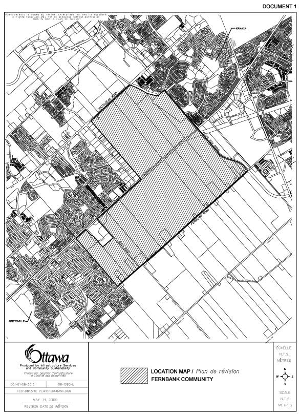
OFFICIAL PLAN AMENDMENT

|
|
Official Plan Amendment No.__ Modifications
du Plan directeur
To the Official Plan for the City of Ottawa