|
10.
ZONING - 3730 AND 3868 INNES ROAD AND 2170 MER BLEUE ROAD Zonage - 3730 ET 3868, CHEMIN INNES
ET 2170, CHEMIN MER BLEUE |
Committee recommendationS as
amended
(This
application is subject to Bill 51)
That
approve:
1. An amendment to the
Zoning By-law 250-2008 to change the zoning of 3730 and 3868 Innes Road
and 2170 Mer Bleue Road from IL2 H(14)-h, IL2[1532] H(14)-h, IL2[1642] H(14)-h
and IH H(11)-h to IL2[1642] H(21)-h and IH[1642] H(21)-h, as detailed in
Document 2 and shown in revised Document 3; and
2. An amendment to the
former City of Gloucester Zoning By-law to change the zoning of 3730 and 3868
Innes Road and 2170 Mer Bleue Road from HMp, HMg and HMe to HMp(E36), HMg(Exx)
and HMx(Exx), as detailed in Document 2 and shown in revised
Document 4.
3.
That there be no further notice
pursuant to Section 34 (17) of the Planning Act.
RecommandationS MODIFIÉES DU Comité
(Cette demande est
assujettie au Règlement 51)
Que le Conseil :
1. approuve
une modification au Règlement de zonage 250-2008 en vue de changer la
désignation de zonage du 3730 et du 3868, chemin Innes ainsi que celle du
2170, chemin Mer Bleue de IL2 H(14)-h, IL2[1532] H(14)-h, IL2[1642] H(14)-h et
IH H(11)-h à IL2[1642] H(21)-h et IH[1642] H(21)-h, tel qu’il est décrit en
détail au document 2 et illustré au document 3 révisé; et
2. approuve
une modification au Règlement de zonage de l’ancienne Ville de Gloucester en
vue de changer la désignation de zonage du 3730 et du 3868, chemin Innes ainsi
que celle du 2170, chemin Mer Bleue de HMp, HMg and HMe à HMp(E36), HMg(Exx)
and HMx(Exx), tel qu’il est décrit en détail au document 2 et illustré au
document 4 révisé.
3. Qu’aucun
autre avis ne soit donné, conformément au paragraphe 34 (17) de la Loi sur
l’aménagement du territoire.
Documentation
1.
Deputy
City Manager’s report, Infrastructure Services and Community Sustainability
dated 8 July 2009 (ACS2009-ICS-PGM-0100).
2. Extract
of Draft Minute, 25 August 2009.
Report to/Rapport au :
Planning
and Environment Committee
Comité de l'urbanisme et de l'environnement
and Council / et au Conseil
Submitted by/Soumis par : Nancy
Schepers, Deputy City Manager
Directrice municipale adjointe
Infrastructure Services and Community Sustainability
Services d’infrastructure et Viabilité des collectivités
Contact Person/Personne-ressource : Michael Wildman,
Manager/Gestionnaire, Development Review-Suburban Services/Examen des projets
d'aménagement-Services suburbains, Planning and Growth Management/Urbanisme et
Gestion de la croissance
(613) 580-2424, 27811 Mike.Wildman@ottawa.ca
|
SUBJECT: |
ZONING -
3730 AND 3868 INNES ROAD AND 2170 MER BLEUE ROAD (FILE NO. D02-02-09-0019) |
|
|
|
|
OBJET : |
Zonage - 3730 ET 3868, CHEMIN INNES ET 2170,
CHEMIN MER BLEUE |
REPORT RECOMMENDATIONS
That the Planning
and Environment Committee recommend Council approve:
1. An amendment to the Zoning By-law
250-2008 to change the zoning of 3730 and 3868 Innes Road and 2170 Mer
Bleue Road from IL2 H(14)-h, IL2[1532] H(14)-h, IL2[1642] H(14)-h and IH
H(11)-h to IL2[1642] H(21)-h and IH[1642] H(21)-h, as detailed in Document 2
and shown in Document 3; and
2. An amendment to the
former City of Gloucester Zoning By-law to change the zoning of 3730 and 3868
Innes Road and 2170 Mer Bleue Road from HMp, HMg and HMe to HMp(E36), HMg(Exx)
and HMx(Exx), as detailed in Document 2 and shown in Document 4.
RECOMMANDATIONS DU RAPPORT
Que le Comité de l’urbanisme et de
l'environnement recommande au Conseil :
1. d’approuver
une modification au Règlement de zonage 250-2008 en vue de changer la
désignation de zonage du 3730 et du 3868, chemin Innes ainsi que celle du
2170, chemin Mer Bleue de IL2 H(14)-h, IL2[1532] H(14)-h, IL2[1642] H(14)-h et
IH H(11)-h à IL2[1642] H(21)-h et IH[1642] H(21)-h, tel qu’il est décrit en
détail au Document 2 et illustré au Document 3; et
2. d’approuver
une modification au Règlement de zonage de l’ancienne Ville de Gloucester en
vue de changer la désignation de zonage du 3730 et du 3868, chemin Innes ainsi
que celle du 2170, chemin Mer Bleue de HMp, HMg and HMe à HMp(E36), HMg(Exx)
and HMx(Exx), tel qu’il est décrit en détail au Document 2 et illustré au
document 4.
BACKGROUND
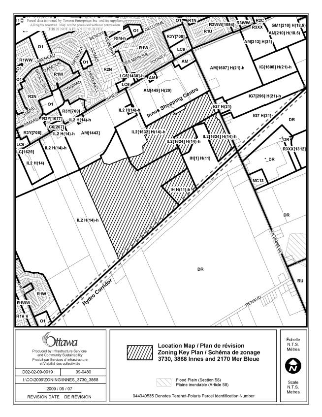
The purpose of the subject application is to request amendments to the Zoning By-law and former City of Gloucester Zoning By-law as they apply to 3730 and 3868 Innes Road and 2170 Mer Bleue Road, highlighted in Document 1.
The subject site consists of approximately 70
hectares of undeveloped land west of Mer Bleue Road within the Orléans
Industrial Park. The site has approximately 500 metres of continuous
public road frontage along Mer Bleue Road that is interrupted only by the
proposed access road to the City’s future snow disposal facility, which the
subject site surrounds. Immediately
north of the site are the Innes Shopping Centre (Wal-mart/Canadian Tire) and
the site of the future Trinity Developments shopping centre (Lowe's/Empire
Theatres) currently under construction.
A substantial City owned woodlot situated between the two shopping
centres also abuts the site’s northern limit, while the hydroelectric power
corridor that bisects the South Orléans community in a southwest to northeast
direction defines the southern extent of the site. The properties immediately west of the site and farther south of
the hydroelectric power corridor could be characterized generally as a
featureless meadow. There are 10
occupied residential properties along the east side of Mer Bleue Road opposite
the site’s public road frontage. The
subject lands are generally flat and featureless, containing only a sparse
cluster of mature trees and shrubs along a minor creek that flows through the
northern half of the site.
The Comprehensive Zoning By-law currently zones the subject lands “Light Industrial” (IL2[1624] H(14)-h, IL2[1532] H(14)-h and IL2 H(14)-h), which generally permits a wide range of low impact light industrial uses, as well as office and office type uses in a campus like industrial park setting. Another parcel is zoned “Heavy Industrial” (IH H(11)-h), which permits a wide range of industrial uses, including those which, by their nature, generate noise, fumes or odours, and are hazardous or obnoxious. All of these parcels are subject to a holding designation, and the applicable maximum height limitations are 11 and 14 metres.
The former City of Gloucester Zoning By-law zones the subject lands “Business Park” (HMp, HMp(E36)), “Industrial General” (HMg) and “Industrial Extraction” (HMe), the range of permitted uses for which is similar to that of the Comprehensive Zoning By-law. These parcels also are subject to a similar holding designation, and the maximum allowable building heights range from 10.7 metres to 13.7 metres.
The subject application proposes amendments to both the Comprehensive Zoning By-law and the former City of Gloucester Zoning By-law to change the current industrial zoning in effect over the subject lands to increase the maximum building height provisions to 21 metres and to consistently apply over the entire subject lands a set of conditions to be met prior to the lifting of the holding designation. The amendment also corrects a minor error pertaining to the subject lands that has gone undetected in the former City of Gloucester Zoning By-law since its initial adoption in 1999. The intent of the proposed amendments is to allow greater flexibility for large office uses on the lands.
DISCUSSION
Official Plan
The Official Plan assigns two land use designations to the subject
site. The majority of the subject site
is designated in the Official Plan as “Employment Area”, which is assigned to
those lands throughout the city where concentrations of at least 2,000 jobs at
a range of densities can be provided in an effort to achieve a balance of
housing and jobs, especially in communities outside the Greenbelt. The uses permitted in this designation
include a variety of industrial and employment generating uses, such as
warehousing, manufacturing, office, institutional, and research and
development. Retail uses are prohibited
from Employment Areas, except for convenience commercial uses occupying small
sites and intended to serve employees of the area and the passing general
public.
The southern portion of the subject lands adjacent to the hydro corridor
are designated as “Mixed Use Centre”, which is the designation applied to
select areas throughout the city that are strategically located along the
rapid-transit network, and that are, or are intended to be, compact centres of
activity containing a wide range of transit-supportive uses, including offices,
institutions, entertainment uses, retail and service uses, and medium and
high-density residential uses. The Plan
considers Mixed Use Centres to be priority locations for development or
redevelopment and, accordingly, encourages the use of such strategies and
techniques as flexible zoning controls, reduced parking requirements, and
increased height and density provisions, to achieve the desired development.
Other Relevant Planning Documents
The affected lands are also subject to the Orléans Industrial Land
Use and Design Study Urban Design Guidelines, December 2003. This document was developed out of Council’s
desire to shape an overall vision for future development within the Orléans
Industrial Park. Among other
initiatives, it establishes a set of urban design guidelines and development
requirements to help direct the visual image of future development within the
park.
A community design plan has not yet been developed for the portion of the subject lands within the Mixed Use Centre designation, but will be required.
Details of Proposed Zoning
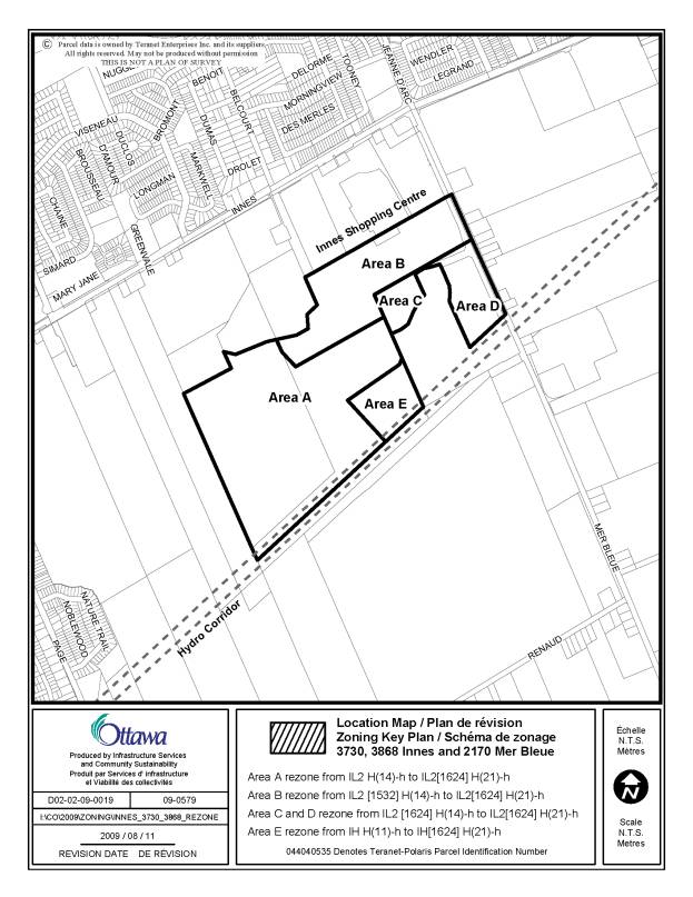
The details of the recommended changes to the Comprehensive Zoning By-law and the former City of Gloucester Zoning By-law appear in Documents 2. The Department is recommending that the five parcels zoned “Light Industrial” and “Heavy Industrial” in the Comprehensive Zoning By-law (parcels A to E in Document 3) be changed to IL2[1624] H(21)-h and IH[1624] H(21)-h, respectively, to increase the maximum building height to 21 metres and to apply a consistent set of conditions to be met prior to the lifting of the holding designation. The exception suffix [1624] lists such conditions, which are the approval of a community design plan for the Mixed Use Centre and proof that the lands can be adequately serviced prior to any future development approvals. The existing exception suffix [1532], which currently applies to parcel B and permits a “storage yard limited to a landscape business” as an additional use, has been removed.
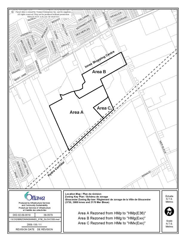
The Department is also recommending that similar and corresponding changes be made to the former City of Gloucester Zoning By-law. Specifically, two of the same five parcels zoned “Business Park” and “Industrial General” (parcels A and B in Document 4) are to be rezoned to HMp(E36) and HMg(E36), respectively, to increase the maximum building height to 21 metres and to consistently apply the same set of conditions to be met prior to the lifting of the holding designation. The exception (E36) attached to these parcels outlines such conditions as well as the increased height limitation. The remaining parcel zoned “Industrial Extraction” (parcel C) is recommended to be changed to “Heavy Industrial - Exception” HMx(E36) to correct the zoning that was applied in error at the time of the adoption of the Zoning By-law and to apply the above same exception.
Rationale
The Orleans Industrial Park, which includes the subject lands, was designated for industrial purposes by the former City of Gloucester well over 25 years ago and has been zoned accordingly for more than 20 years. To date, not a single industrial use occupies the park primarily because the lands are not serviced, but also because the industrial marketplace has shown little interest in the park’s location as a focus of warehouse, assembly and manufacturing establishments. In recent years, the development of two large commercial shopping centres along the park’s Innes Road frontage has occurred through a combination of Official Plan and Zoning By-law amendments and negotiated settlements to Ontario Municipal Board appeals. In addition, the southern portion of the park was designated as a mixed-use centre, as noted above, in part to create more favourable conditions for development of the adjacent employment lands. As a result of these recent policy changes, the future development potential of the park now appears to be more suited for prestige industrial and office uses than the lower profile, more industrial type uses that the former municipality contemplated for these lands. It is within this context, therefore, that the proposed amendment has been evaluated.
Staff evaluated
the proposed zoning amendment in terms of its appropriateness and the impact
that the increased building height would have on the surrounding uses. With respect to the appropriateness of the
increase in building height, staff reviewed the Employment Area and Mixed Use Centre
policies of the Official Plan, the intent of the current zoning in force, and
the height provisions of similar zones in the immediate vicinity of the subject
site. While the Employment Area
policies provide no direction
respecting building height, the Mixed Use Centre
policies specifically encourage
the use of such strategies and techniques as increased height to achieve the
desired development. In fact, the lands
east of Mer Bleue Road in proximity of the subject lands are zoned “Mixed Use
Centre” (MC13 and MC[1573]) and permit maximum building heights ranging from
seven to 10 storeys, or 25 metres to approximately 30 metres. These performance standards implement in
part the recently approved community design plan for the Mer Bleue Mixed Use
Centre. Therefore, it is reasonable to
suggest that the future required community design plan yet to be undertaken for
the portion of the subject lands within the Mixed Use Centre designation may
possibly establish a similar maximum building height. In the meantime, to apply a maximum building height of 21 metres
to these lands, as proposed, would be appropriate.
The intent of the “Light Industrial” (IL) zone currently in force over
the subject lands is, in part, to permit a wide range
of low impact light industrial uses as well as office and office type uses in a
campus like industrial park setting.
The Comprehensive Zoning
By-law establishes a maximum building height of 18 metres for the IL zone
category unless otherwise specified by exception or specific height
requirement. In the case of the subject
lands, specific height limitations of 11 and 14 metres apply. These more restrictive height limitations
were established by the former municipality when the industrial park was
largely undeveloped and were intended to attract the large floor plate, low-rise
industrial uses, such as warehouses, assembly and manufacturing
establishments. However, the IL zone
also permits other more prestige industrial and office uses that generally
require more flexibility in building height than the current zoning provides. Accordingly, staff looked to how other
nearby lands in the Orléans Industrial Park are zoned for purposes of
comparison. The majority of the lands
to the north and east of the subject lands are zoned either “General
Industrial” (IG) or “Arterial Mainstreet” (AM). These lands are subject to maximum building height limits of
either 20 or 21 metres, which is comparable to what is proposed for the subject
lands. Therefore, it is reasonable once
again to suggest that the proposed increase in the maximum building height to
21 metres applied over the entire subject lands is appropriate. Doing so would not preclude the large floor
plate, low-rise industrial uses from locating there.
As noted, the subject lands are
part of the Orléans Industrial
Park, which extends over the majority of the lands from Innes Road south to the
hydroelectric power corridor, and encompasses several residential properties
that have existed since the time the lands were rural. These residential properties lie within
industrial zones and are now deemed legal non-conforming uses. Ten of such residential properties front
along the east side of Mer Bleue Road opposite the subject lands. Staff evaluated the
impact that the proposed increased building height would have primarily on these
surrounding residential uses and
considered such matters as increased traffic and noise, and loss of enjoyment
of property.
The requested amendment essentially requests an increase in building
height of seven metres above the current maximum of 14 metres. This represents an increase of two to three
floors above the three to four storeys that are permissible today abutting Mer
Bleue Road. The proposed amendment does
not seek a change in the uses currently permitted (except in the case of the
proposed zoning correction to the by-law of the former municipality, discussed
below) or an increase in the development density of the site. In essence, the amendment seeks to provide
more flexibility in built form throughout the entire subject lands. As such, it is expected that any increase in
traffic volume or noise levels associated with the proposed increased height
provision can be mitigated and accommodated.
Similarly, it is anticipated that there would be minimal impact on the
residents’ enjoyment of their properties due to light infiltration and loss of
access to sunlight. Light infiltration
is a matter of site design that is addressed through the site plan control
approval process. With respect to
access to sunlight, the potential increased building height of up to three
storeys adjacent to Mer Bleue Road would likely cast longer shadows over a few
of the properties during the late afternoons of the summer months. However, because most of the affected
residential properties are directly opposite the subject site and therefore
would already be impacted by the shadow of a four-storey building if one
existed, the proposed increased maximum building height would have negligible
impact on these properties.
The proposed by-law amendment also changes the zoning in effect over a
portion of the subject lands identified as parcel C on Document 4 to correct an
error that has existed since the adoption of the former municipality’s Zoning
By-law in 1999. The current “Industrial
Extraction” (Me) zone is intended to recognize active or future quarry
operations. There is no such current or
intended use of the subject property.
Therefore, the amendment proposes to change the zoning to the more
appropriate “Heavy Industrial” (Mx) zone category.
Finally, the proposed amendment seeks to apply a consistent set of
conditions for the lifting of the holding designation that is already in effect
over the entire subject lands. Two
differently worded sets of conditions are currently in effect over the subject
lands even though the intent of each is the same. Staff support this change.
The details of the proposed single set of conditions are outlined in
Document 2.
In conclusion, it is staff’s opinion that the proposed Zoning By-law amendment conforms to the relevant policies of the Official Plan, and that the increased maximum building height provision is appropriate and compatible with both the surrounding industrial and non-industrial uses.
ENVIRONMENTAL IMPLICATIONS
City staff, in consultation with the Rideau Valley Conservation Authority, have identified no natural heritage or natural hazard features that would preclude the approval of the subject proposed zoning amendment.
CONSULTATION
Notice of this application was carried out in accordance with the City’s Public Notification and Consultation Policy. The Ward Councillor is aware of this application and the staff recommendation.
Two local residents expressed concerns with the potential impact the proposed zoning change could have on adjacent residential properties. One other resident expressed support. The concerns are addressed in Document 5.
LEGAL/RISK MANAGEMENT IMPLICATIONS
There are no legal/risk management implications associated with this report.
FINANCIAL IMPLICATIONS
N/A
APPLICATION PROCESS TIMELINE STATUS
This application was processed by the “On Time Decision Date” established for the processing of Zoning By-law amendment applications.
SUPPORTING DOCUMENTATION
Document 1 Location Map
Document 2 Details of Recommended Zoning
Document 3 Zoning Map – Comprehensive Zoning By-law
Document 4 Zoning Map – Former Gloucester Zoning By-law
Document 5 Consultation Details
DISPOSITION
City Clerk and Legal Services Branch, Legislative Services to notify the owner, Mr. Kevin McCrann, Emparrado Corporation, 190 Lisgar Street, Ottawa, ON K2P 0C4, applicant, Mr. Daniel Paquette Paquette Planning Associates Ltd., 56 Hutchison Avenue, Ottawa, ON K1Y 4A3; OttawaScene.com, 174 Colonnade Road, Unit #33, Ottawa, ON K2E 7J5, and Ghislain Lamarche, Program Manager, Assessment, Financial Services Branch (Mail Code: 26-76), of City Council’s decision.
Planning and Growth Management to prepare the implementing by-law, forward to Legal Services and undertake the statutory notification.
Legal Services to forward the implementing by-law to City Council.
LOCATION
MAP DOCUMENT 1
DETAILS OF RECOMMENDED ZONING DOCUMENT
2
Proposed Changes to the Comprehensive Zoning By-law
The proposed zoning amendment affects one section and the zoning map of the Comprehensive Zoning By-law, as amended. The proposed changes are outlined in general terms below.
1. The lands shown on Document 3 will be rezoned as follows:
a. Area A from IL2 H(14)–h to IL2[1624] H(21)–h;
b. Area B from IL2[1532] H(14)–h to IL2[1624] H(21)–h;
c. Area C from IL2[1624] H(14)–h to IL2[1624] H(21)–h;
d. Area D from IL2[1624] H(14)–h to IL2[1624] H(21)–h; and,
e. Area E from IH H(11)–h to IH[1624] H(21)–h.
2. Exception [1624] of Section 239, Urban Exceptions, will be amended by deleting the zone code currently contained within Column II and replacing it with IL2[1624] H(21)–h and IH[1624] H(21)–h, and by deleting the exception provision currently contained within Column V in its entirety and replacing it with the following new exception provision:
Proposed Changes to By-law 333-1999
The proposed zoning amendment affects one section and zone map of former City of Gloucester By-law 333-1999, as amended. The proposed changes are outlined in general terms below.
1. Section 9.15 Exceptions to Industrial Zones is amended by deleting the text to the existing exception Mp(E36) listed at subsection 9.15.36 in its entirety and replacing it with the following new special provisions or ones having the same effect:
a. Any lands zoned Mp(E36) that are subject to a holding designation, shown as HMp(E36) on Map 14B of this By-law, may be used for any permitted use in the Mp zone at such time as the following conditions are met and the holding designation is removed:
b. In any area on Schedule A of this By-law designated Mp(E36), the maximum permitted building height is 21.0 metres.
2. The lands shown as Area A on Document 4 are rezoned from HMp to HMp(E36).
3. The lands shown as Area B on Document 4 are rezoned from HMg to HMg(Exx).
4. Section 9.15 Exceptions to Industrial Zones is amended by creating a new exception zone, Mg(Exx). The new Mg(Exx) zone shall contain the following provisions or ones having the same effect:
a. Any lands zoned Mg(Exx) that are subject to a holding designation, shown as HMg(Exx) on Map 14B of this By-law, may be used for any permitted use in the Mg zone at such time as the following conditions are met and the holding designation is removed:
b. In any area on Schedule A of this By-law designated Mg(Exx), the maximum permitted building height is 21.0 metres.
5. The lands shown as Area C on Document 4 are rezoned from HMe to HMx(Exx).
6. Section 9.15 Exceptions to Industrial Zones is amended by creating a new exception zone, Mx(Exx). The new Mx(Exx) zone shall contain the following provisions or ones having the same effect:
a. Any lands zoned Mx(Exx) that are subject to a holding designation, shown as HMx(Exx) on Map 14B of this By-law, may be used for any permitted use in the Me zone at such time as the following conditions are met and the holding designation is removed:
b. In any area on Schedule A of this By-law designated Mx(Exx), the maximum permitted building height is 21.0 metres.
Revised DOCUMENT 3
ZONING MAP – COMPREHENSIVE ZONING BY-LAW
Revised DOCUMENT 4
ZONING MAP – FORMER GLOUCESTER ZONING BY-LAW
CONSULTATION DETAILS DOCUMENT
5
NOTIFICATION AND CONSULTATION PROCESS
Notification and public consultation was undertaken in accordance
with the Public Notification and Public Consultation Policy approved by City
Council for Zoning By-law amendments. No public information sessions
were held in the community.
PUBLIC COMMENTS
Comments were
received from three residents who own properties fronting on Mer Bleue Road
adjacent to the subject lands. Two of
the residents expressed concern over the increased traffic, noise and light
emissions that the proposed change to the maximum building height may cause. The
possibility of ground floor retail stores opened late into the evening, for
instance, may contribute to the loss of enjoyment of their properties due to
increased traffic, noise and excessive amounts of light infiltration. The third resident supports the proposed
zoning change by suggesting that large employment generators are needed in
Orléans and the subject site would be ideal for such uses.
Staff Response
The residents’ concerns are addressed in the Discussion section of this report.