|
3. Hunt Club Road In-Service Road Safety Rocade De Hunt Club – Examens
De La Sécurité Des Routes En Service |
Committee
Recommendations
That Council approve:
1. Implementation
of all of the low and medium cost strategies identified in the report for the
Hunt Club Road corridor between Airport Parkway and Albion Road.
2. That
the proposed roadway modification, as shown in Document 2, be constructed to
provide improved sightlines for northbound left turning vehicles on Bridle Path
Drive on the approach to Hunt Club Road;
3. That
the proposed roadway modification, as shown in Document 2, be constructed to
widen Hunt Club Road, between Daze Street and the entrance to the Southwest
Transitway to accommodate a reserved lane to improve transit access;
4. That
staff undertake a traffic operational
review to address the turning movement safety issues at median breaks on the
approaches to Bank Street and Hunt Club Road intersection, as identified in the
report;
5. That
the Public Works department be directed to include as part of the Strategic
Initiatives projects in the 2010 Draft Capital Budget for council
consideration, the installation of a permanent Variable Message Sign on Hunt
Club Road at an estimated cost of $50,000 as a component of the 2010 Traffic
Incident Management;
6. That
the Public Works department and Real Estate Services proceed with the
acquisition of the lands shown in Document 3.
7. That
the Public Works department submit as part of the future budget process $90,000 for the construction of the smart
channel work described in this Report and shown in Document 3.
Recommandations du comité
Que le Conseil
approuve :
1. la mise en œuvre de toutes les
stratégies à faible ou à moyen coût retenues dans le rapport pour le couloir du
chemin Hunt Club entre la promenade de l'Aéroport et le chemin Albion;
2. la réalisation de la modification de
chaussée proposée, illustrée dans le document 2, afin d'améliorer les lignes de
visibilité des conducteurs se dirigeant vers le nord et tournant à gauche sur
la promenade Bridle Path à l'approche du chemin Hunt Club;
3. la réalisation de la modification de
chaussée proposée, illustrée dans le document 2, afin d'élargir le chemin Hunt
Club entre la rue Daze et l'entrée du Transitway sud-ouest pour y aménager une
voie réservée qui améliorera l'accès des autobus;
4. la réalisation d'un examen opérationnel
de la circulation par le personnel municipal portant sur les problèmes de
sécurité, relevés dans le rapport, que posent les virages aux coupures de
terre-plein aux approches de l'intersection de la rue Bank et du chemin Hunt
Club;
5. l'inclusion par Travaux publics, parmi
les projets d'Initiatives stratégiques contenus dans les prévisions
préliminaires du budget des immobilisations de 2010 à soumettre à l'examen du
Conseil, d'une proposition d'installer un panneau permanent à message variable
sur le chemin Hunt Club, au coût estimatif de 50 000 $, en tant que
composante de la Gestion des incidents de circulation de 2010;
6. l'acquisition par Travaux publics et
les Services immobiliers des terrains indiqués dans le document 3;
7. la présentation par Travaux publics,
dans le cadre de la préparation du futur budget de fonctionnement, d'une
proposition d'affecter 90 000 $ aux travaux de construction des couloirs de
virage intelligents décrits dans le présent rapport et illustrés dans le
document 3.
Documentation
1. Deputy City Manager’s report, City
Operations, dated 30 September 2009 (ACS2009-COS-PWS-0022).
Report to/Rapport au:
Transportation Committee
Comité des transports
and
Council/et Conseil
30 September 2009 / 30 septembre 2009
Steve
Kanellakos, Deputy City Manager/Directeur municipal adjoint
City Operations/Opérations
municipales
Contact
Person/Personne ressource:
John
Manconi, General Manager/directeur générale, Public Works/TravauxPublics
613-580-2424, extension 21110,
John.Manconi@ottawa.ca
|
SUBJECT: |
Hunt club road
In-Service Road Safety Review |
|
OBJET: |
Rocade de Hunt Club – Examens
de la sécurité des Routes en Service |
REPORT
RECOMMENDATIONS
That
Transportation Committee recommend that Council approve:
1.
Implementation of all of the low and medium cost
strategies identified in the report for the Hunt Club Road corridor between
Airport Parkway and Albion Road.
2.
That the proposed roadway modification, as shown
in Document 2, be constructed to provide improved sightlines for northbound
left turning vehicles on Bridle Path Drive on the approach to Hunt Club Road;
3.
That the proposed roadway modification, as shown
in Document 2, be constructed to widen Hunt Club Road, between Daze Street and
the entrance to the Southwest Transitway to accommodate a reserved lane to
improve transit access;
4.
That staff
undertake a traffic operational review to address the turning movement
safety issues at median breaks on the approaches to Bank Street and Hunt Club
Road intersection, as identified in the report;
5.
That the Public Works department be directed to
include as part of the Strategic Initiatives projects in the 2010 Draft Capital
Budget for council consideration, the installation of a permanent Variable
Message Sign on Hunt Club Road at an estimated cost of $50,000 as a component
of the 2010 Traffic Incident Management;
6.
That the Public Works department and Real Estate
Services proceed with the acquisition of
the lands shown in Document 3.
7.
That the Public Works department submit as part of the future budget process $90,000 for the construction of the smart
channel work described in this Report and shown in Document 3.
RECOMMANDATIONS DU RAPPORT
Que le Comité des transports
recommande au Conseil d'approuver :
1.
la mise en œuvre de toutes les stratégies à faible ou à moyen coût
retenues dans le rapport pour le couloir du chemin Hunt Club entre la promenade
de l'Aéroport et le chemin Albion;
2.
la réalisation de la modification de chaussée proposée, illustrée dans
le document 2, afin d'améliorer les lignes de visibilité des conducteurs se
dirigeant vers le nord et tournant à gauche sur la promenade Bridle Path à
l'approche du chemin Hunt Club;
3.
la réalisation de la modification de chaussée proposée, illustrée dans
le document 2, afin d'élargir le chemin Hunt Club entre la rue Daze et l'entrée
du Transitway sud-ouest pour y aménager une voie réservée qui améliorera
l'accès des autobus;
4.
la réalisation d'un examen opérationnel de la circulation par le
personnel municipal portant sur les problèmes de sécurité, relevés dans le
rapport, que posent les virages aux coupures de terre-plein aux approches de
l'intersection de la rue Bank et du chemin Hunt Club;
5.
l'inclusion par Travaux publics, parmi les projets d'Initiatives
stratégiques contenus dans les prévisions préliminaires du budget des
immobilisations de 2010 à soumettre à l'examen du Conseil, d'une proposition
d'installer un panneau permanent à message variable sur le chemin Hunt Club, au
coût estimatif de 50 000 $, en tant que composante de la Gestion des
incidents de circulation de 2010;
6.
l'acquisition par Travaux publics et les Services immobiliers des
terrains indiqués dans le document 3;
7.
la présentation par Travaux publics, dans le cadre de la préparation du
futur budget de fonctionnement, d'une proposition d'affecter 90 000 $ aux
travaux de construction des couloirs de virage intelligents décrits dans le
présent rapport et illustrés dans le document 3.
EXECUTIVE SUMMARY
Hunt Club Road is a four-lane divided road between Airport Parkway and Albion Road. The study area comprises approximately 1.2 km with a posted speed limit of 60 km/h.
The safety study reviewed a total
of 489 collisions reported between January 1, 2002 and December 31st,
2006. For the study period, there were no fatal
collisions on the corridor but 28% (136) of all collisions resulted in injuries
and 72% (353) of all collisions resulted in Property Damage Only (PDO). As
well, six cyclists and eight pedestrians were involved in collisions. Four
collisions involving cyclists resulted in injuries and two in property damage
only (PDO). The total societal economic loss due to collisions resulting in
injuries and property damage only (PDO) was estimated close to $14.5
million in 2006 figures.
The Department reviewed the study findings to
prepare an implementation plan based on both low cost and medium cost
strategies.
Low cost strategies include: upgrading/adding signs and traffic signals display, continuation of the enforcement / education campaign and conducting a traffic operational study on existing median breaks on the approach to Bank Street and Hunt Club Road intersection. Medium cost strategies include modifying northbound left turn lane at Bridle Path Drive; extending the dedicated transit lane entrance to the northbound Transitway ramp; improving driving surface (2010-2013); acquiring the land necessary to reconstruct the northbound right turn (lane) channel to a smart channel at the intersection of Hunt Club Road and Albion Road; and developing an incident management plan.
Details of the study findings and recommendations
are contained in the following report.
RÉSUMÉ
Le chemin Hunt Club est une route à
chaussées séparées à quatre voies entre
la promenade de l’Aéroport et le chemin Albion. L’aire d’étude s’étend
sur environ 1,2 km avec une limite de vitesse affichée à 60 km/h.
L’étude
sur la sécurité comprenait l’examen d’un nombre total de 489 collisions
signalées entre le 1er janvier 2002 et le
31 décembre 2006. Aucune collision mortelle n’a eu lieu sur ce
tronçon, pour la période visée par l’étude, mais 28 %(136) de l’ensemble des
collisions ont causé des lésions corporelles et 72 % (353) de l'ensemble
des collisions ont entraîné des dommages matériels uniquement. De plus, six
cyclistes et huit piétons ont été touchés par des collisions. Quatre collisions
touchant des cyclistes ont entrainé des lésions corporelles et deux collisions
ont entrainé des dommages matériels uniquement. La perte économique totale pour
la société en raison de collisions entraînant des lésions corporelles et des
dommages matériels uniquement a été estimée à près de 14,5 millions de dollars
pour les chiffres de 2006.
Le Service a examiné les conclusions de l’étude
pour préparer un plan de mise en œuvre fondé à la fois sur les recommandations
à faibles coûts et celles à coûts plus élevés.
Les stratégies à faibles coûts
comprennent les éléments suivants : une amélioration et une augmentation
des panneaux de signalisation et des feux de circulation, une poursuite de la
campagne d’application des règlements et d’éducation et la réalisation d’un
examen opérationnel de la circulation pour les coupures actuelles des terre-pleins à l’abord de l’intersection de la
rue Bank et du chemin Hunt Club. Les stratégies celles à coûts plus
élevés comprennent une modification du virage
à gauche en direction nord sur la promenade Bridle Path un élargissement
de la voie réservée pour l’entrée du transport en commun vers la bretelle nord
du Transitway une amélioration de la
surface de la chaussée (de 2010 à 2013); une acquisition du terrain
nécessaire pour reconstruire la voie de virage à droite en direction nord vers
une bretelle intelligente à l’intersection
du chemin Hunt Club et du chemin Albion et l’élaboration d’un plan de
gestion des incidents.
Les détails des conclusions et des
recommandations de l’étude se trouvent dans le rapport suivant.
Under the conditions
described above, it was deemed appropriate to conduct an In-service Road Safety
Review (ISRSR) following the principles and tasks outlined in "The
Canadian Guide to In-service Road Safety Reviews" (2004 Edition) produced
by the Transportation Association of Canada (TAC).
The study area on Hunt Club Road comprises
approximately 1.2 km from the Airport Parkway’s ramps to Albion Road, as shown in Document 1. The posted speed limit on this road segment is 60 km/h. Also, the study
included a review of the short-stretches of adjacent roads as shown in Document
1.
The outcome of the
field observations and analysis of the data used for the operational and safety
review are summarized in the following section as well as a road safety
implementation plan.
DISCUSSION
The safety study
reviewed a total of 489 collisions reported between January 1, 2002 and
December 31st, 2006. For
the study period, no fatal collisions occurred on the corridor but 28% (136) of
all collisions resulted in injuries and 72% (353) of all collisions resulted in
Property Damage Only (PDO). As well, six cyclists and eight pedestrians were
involved in collisions. Four collisions involving cyclists resulted in injuries
and two in property damage only (PDO). The collisions involving cyclists didn’t
represent a pattern at any location within the study corridor.
The collision review
indicated that the high-frequency collision groupings occurred at the following
locations:
At the intersection of:
§ Hunt Club Road and Airport Parkway (86 collisions);
§ Hunt Club Road and Bridle Path Drive/Daze Street (100 collisions);
§ Hunt Club Road and Bank Street (98 collisions); and
§ Hunt Club Road and Albion Road (62 collisions).
On Hunt Club Road segments between:
§
Airport Parkway and Bridle Path Drive\Daze
Street (40 collisions);
§ Bridle Path Drive\Daze Street and Bank Street (34 collisions); and,
§ Bank Street and Albion Road (14 collisions).
At the accesses on:
§ Bank Street at Towngate Plaza (29 collisions); and
§ Bank Street at Mews Plaza (26 collisions).
The analysis showed that the majority of the
489 collisions occurred within a certain degree of favorable conditions. For example, 58% (285) of all collisions
occurred during the daytime, 67% (328) of all collisions occurred on dry road
surface conditions and 79% (386) of all collisions occurred within a clear
environment.
Over 50% of the 489 collisions involved rear
end collisions followed by turning movement collisions which reported 17% of
all collisions. More than 75 % of the 86
collisions that occurred at Hunt Club Road and Airport Parkway intersection
were eastbound and westbound rear end collisions. The remaining locations
reported similar rear end collision numbers ranging from 50% to 68% of all
collisions at each location.
During the study period (2002-2006), the total societal economic
loss due to collisions resulting in injuries and property damage only (PDO) was
estimated close to $14.5 million in 2006 figures. This cost figure was based on the “Willingness-to-Pay”
figures provided by the 2007 MTO-Transport
Canada document “Analysis and Estimation of the Social Cost of Motor Vehicle
Collisions in Ontario –2004”.
In addition to the collision data, the Ottawa
Police Service made available a list of all offence notices issued to motorists
within the study corridor over the period January 1, 2002 – December 31, 2006.
The study acknowledges the following information.
“A total of
2,443 offence notices were issued during the five year period. The primary
location of the offences was the intersection of Hunt Club Road and Bank
Street, followed by Hunt Club Road and Albion Road. Significant Highway Traffic
Act offences included speeding (356), red light running (174), and careless
driving (113). Offences were most common on a weekday (as opposed to the
weekend) and during afternoon hours.”
·
“End-of-queue
collisions due to sudden stopping or slowing;
·
Driver
frustration leading to aggressive behaviours such as red light running, and
resultant angle collisions;
·
Drivers
failing to clear an intersection at the end of a green phase due to congestion
downstream; and
·
Rear
end, sideswipe, left-turn opposing and left-turn adjacent collisions as drivers
exiting/entering commercial plaza accesses and unsignalized side-streets
attempt to negotiate their way through queued traffic.”
Low Cost
Strategies
§ Upgrading/adding signs and traffic signals display;
§ Conducting a traffic operational study on existing median breaks on the approach to Bank Street and Hunt Club Road intersection;
§ Continuing enforcement/education campaigns; and
§ Continuing to monitor collision frequency on the study corridor.
New
signs will be added to provide drivers positive guidance in selected locations
such as the westbound Hunt Club Road approaching the OC Transpo Transitway
entrance to indicate the restricted movements (to the Transitway) and permitted
movements (to Airport Parkway). New ‘No
Trucks’ sign will be installed to the inner eastbound left turn overhead lane
designation sign on Hunt Club Road at Bank Street. Also, reflective tape
will be installed around the primary signal head backboards on northbound Bank
Street approaching Hunt Club Road. The estimated cost of
implementing these recommendations is $20,000 and with Council approval the work will commence in fall 2009, with a
planned completion time of spring 2010.
The study revealed a cluster of collisions involving northbound vehicles on Bank Street making a left turn into the Mews Plaza entrance north of Hunt Club Road. Also, extensive queuing, delays and a high frequency of collisions have been reported due to the turning movements at other existing median breaks on the approach to the Bank Street and Hunt Club Road intersection. It is recommended that a traffic operational study be undertaken to identify the options for managing the safety risk at these locations and to also consult with affected business owners. The cost to undertake this study is approximately $25,000 and it will be done in 2010.
Continue the work in education and enforcement for Hunt Club Road between Airport Parkway and Albion Road, identified as a target location through the annual Integrated Road Safety Program campaign.
Medium Cost
Strategies (within 1-5 years)
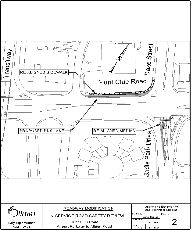
§ Modifying northbound left turn lane at Bridle Path Drive;
§ Extending the dedicated transit lane entrance to the northbound Transitway ramp;
§ Improving driving surface (2010-2013);
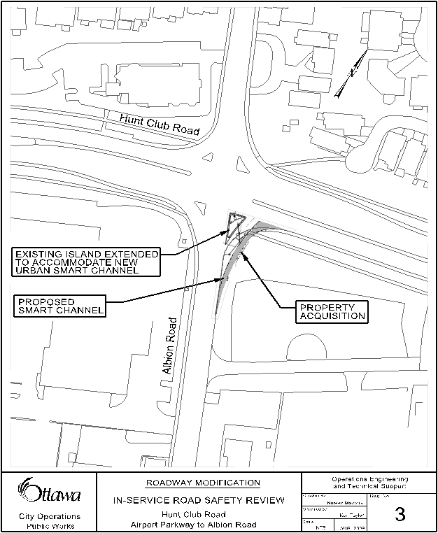
§ Acquiring the land necessary to reconstruct the northbound right turn (lane) channel to a smart channel at the intersection of Hunt Club Road and Albion Road; and
§ Developing an incident management plan.
Four
road measures in selected locations are recommended as medium cost
recommendations. The roadway modifications at the Hunt
Club Road and Daze Street/Bridle Path Drive, as shown in Document 2, will
improve sightlines for northbound left turning vehicles on Bridle Path Drive
and it will enhance transit access to the northbound Transitway ramp. The
estimated cost of this project is $150,000 and it will be implemented in 2010.
The proposed reconstruction of the right turn (lane)
channel to a smart channel would provide a smoother angle of entry on the
southeast corner of Albion Road and Hunt Club road intersection. Also, it will improve the sightlines
for the northbound drivers who are making a right turn movement onto Hunt Club
Road. The implementation of this strategy, as shown in
Document 3, is subject to successfully acquiring the necessary
land. The real estate process to purchase the land will be initiated in 2010
and it will be funded through the 2009 Safety Improvement Program.
Further, an incident management plan will be developed in 2010 to
relieve incident related congestion in the study corridor. This plan would include the following:
- Developing pre-planned detour routes in the event of road closures;
·
Installing a permanent variable message sign
(VMS) in advance of the corridor to inform motorists of incidents or delays due
to congestion; and
·
Installing an additional permanent traffic
camera at the intersection of Hunt Club Road and Bridle Path Drive\Daze Street.
This plan will allow the traffic operations center
to monitor the flow of traffic and make traffic signal timing adjustments to
maximize the efficient flow of traffic. Advanced real-time information provided
to drivers will allow them time to make the decision of taking alternate
routes. The estimated cost of
installing one permanent VMS is $50,000. Subject to Council approval, it will
be funded through the 2010 Traffic Incident management Program. The
additional camera is estimated to cost $20,000 and it is being funded through
the 2009 Advanced Traffic Management System Program.
As a part of the City Resurfacing and Preservation
Plan, the roadway surface condition on Hunt Club Road from west of Airport
Parkway and to Albion Road is being evaluated to determine the suitability of
different surface treatments and cost. The implementation year of the roadway
surface treatment is yet to be determined and it is likely to be done in the
next three years. It is expected that this treatment would reduce wet road
surface rear-end collisions.
CITY STRATEGIC DIRECTIONS
The safety
recommendations included in this report are consistent with the Service
Priorities for the City Strategic Plan 2007 – 2010, specifically the following:
§ Transportation Priority, Objective 1 - Continue to undertake Road Safety Audits along major corridors in order to address traffic safety issues.
The principles of the
Ottawa 20/20 Transportation Master Plan (TMP), Section 6.5 Road Safety,
approved by Council at its meeting November 28, 2008, are reflected in the
safety strategies recommended in this report.
CONSULTATION
The Ward Councillors have been briefed on the findings of the road safety study and the implementation plan set out in this report and they are supportive of the recommendations and workplan. Staff has consulted with the Infrastructure Services and Community Sustainability Department regarding this report.
On September 2009,
property owners on the vicinity of the intersection at the Hunt Club Road and
Bank Street were informed on the outcome of the In-Service Road Safety Review.
LEGAL/RISK MANAGEMENT IMPLICATIONS
FINANCIAL IMPLICATIONS
The financial
implications include:
Low cost strategies at an estimated cost of $45,000 to be charged to capital account 904905, 2009 Safety Improvement Program;
Roadway modifications at the Hunt Club Road and Daze Street/Bridle Path Drive intersection at an estimated cost of $150,000 to be charged to two capital accounts; the amount of $100,000 to be charged to capital account 904247, 2007 Transit Priority Corridor Implementation and the amount of $50,000 to be charged to capital account 904905, 2009 Safety Improvement Program;
Installation
of a new camera at Hunt Club Road and Daze Street/Bridle Path Drive at an
estimated cost of $20,000 to be charged to capital account 905127, 2009
Advanced Traffic Management System;
Public
Works will include as part of the Strategic Initiatives projects in the 2010
Draft Capital Budget for Council consideration the installation of a permanent
VMS on Hunt Club Road at an estimated cost of $50,000 as a component of the
2010 Traffic Incident Management;
The
acquisition of the lands shown in Document 3 is estimated at $33,000, such
acquisition to commence and proceed immediately. This will be charged to capital account
904905, 2009 Safety Improvement Program;
Public
Works will include as part of the 2011 Safety Improvement Program Budget for
Council consideration an estimated amount of $90,000 for the construction of
the smart channel work described in this report and shown in Document 3.
SUPPORTING
DOCUMENTATION
Document 1 - Hunt Club Road Study Area (Immediately
following the report)
Document 2 - Hunt
club Road and Daze Street\Bridle Path Drive Study Area (Immediately following the report)
Document 3 - Hunt
club Road and Albion Road Study Area (Immediately following the report)
DISPOSITION
Following Council approval, the Department of
Public Works will implement the recommendations identified in this report. The following work will be included in the
work plan for future years:
· Complete upgrade and addition of signs and traffic signals display by the spring of 2010;
·
Proceed
with the traffic operational study to assess the turning movements issues and
traffic delays at the median breaks on the approaches to Bank Street and Hunt
Club Road intersection by 2010;
· Construct the modified northbound left turn lane at Bridle Path Drive by 2010;
· Widen Hunt Club Road, between Daze Street and the entrance to the Southwest Transitway to accommodate a reserved lane for transit by 2010;
· Begin the negotiation to purchase the land necessary to reconstruct the existing northbound right turn (lane) channel to a smart channel at Albion Road and Hunt Club Road intersection by 2010;
· Develop an incident management plan by 2010;
· Conduct a new five-year collision analysis to monitor the frequency of collisions on the study corridor by 2016; and
· Continue with the annual education\enforcement campaigns on the study corridor.
DOCUMENT 1
Hunt club Road
DOCUMENT 2
Hunt club Road and
Daze Street\bridle Path Drive
DOCUMENT 3
Hunt club Road and
albion road