|
3. ZONING – PART OF 972 WILLIAM MOONEY ROAD ZONAGE – PARTIE DU 972, CHEMIN WILLIAM MOONEY |
Committee Recommendation
(This application is subject to Bill 51)
That Council approve an amendment to Zoning
By-law 2008-250 to change the zoning of part of 972 William Mooney Road from
Rural Countryside Zone (RU) to Rural Residential Subzone 3 (RR3) as shown in
Document 1.
Recommandation du Comité
(Cette
demande est assujettie au Règlement 51)
Que le Conseil approuve une modification au Règlement de zonage 2008-250
afin de changer la désignation de zonage d’une partie du 972, chemin William
Mooney de Zone d’espace rural (RU) à Zone résidentielle rurale, sous-zone 3
(RR3), tel qu’il est indiqué dans le Document 1.
Documentation
1.
Deputy
City Manager's report Infrastructure Services and Community Sustainability
dated 7 October 2009 (ACS2009-ICS-PGM-0197).
Report to/Rapport au :
Agriculture and Rural Affairs Committee
Comité d'agriculture et des affaires rurales
and Council / et au Conseil
07 October 2009 / le 07 octobre 2009
Submitted by/Soumis par : Nancy Schepers, Deputy City Manager/
Directrice municipale adjointe,
Infrastructure Services and Community
Sustainability/
Services d’infrastructure et Viabilité des collectivités
Contact Person/Personne-ressource :
Derrick Moodie, Manager/Gestionnaire,
Development Review-Rural Services/Examen des projets d'aménagement-Services
ruraux, Planning and Growth Management/Urbanisme et Gestion de la croissance
(613) 580-2424, 15134 Derrick.Moodie@ottawa.ca
|
SUBJECT: |
|
|
|
|
|
OBJET : |
REPORT RECOMMENDATION
That the recommend Council approve an amendment to
Zoning By-law 2008-250 to change the zoning of part of 972 William Mooney Road
from Rural Countryside Zone (RU) to Rural Residential Subzone 3 (RR3) as shown
in Document 1.
RECOMMANDATION DU
RAPPORT
Que le Comité de l’agriculture et des affaires
rurales recommande au Conseil d’approuver une modification au Règlement de
zonage 2008-250 afin de changer la désignation de zonage d’une partie du 972,
chemin William Mooney de Zone d’espace rural (RU) à Zone résidentielle rurale,
sous-zone 3 (RR3), tel qu’il est indiqué dans le Document 1.
BACKGROUND
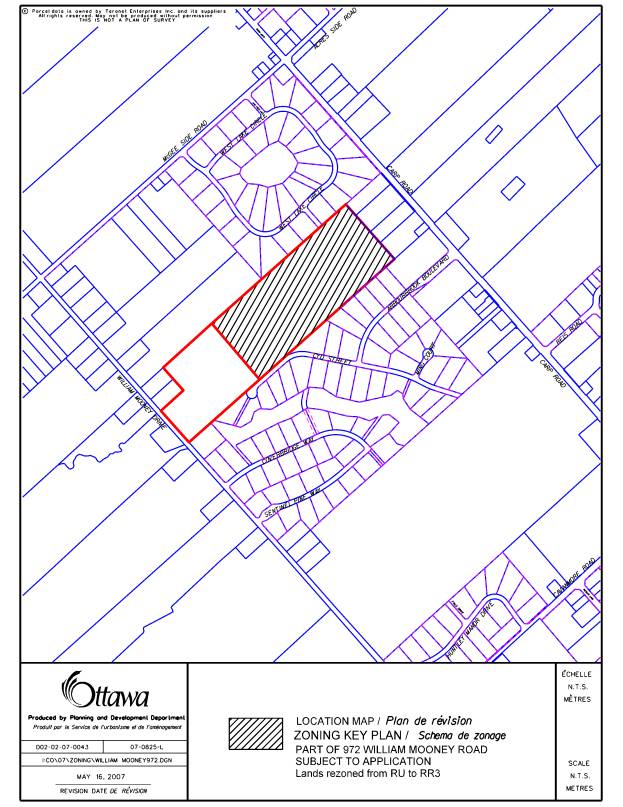
The subject property at 972 William Mooney Road is located on the east side of William Mooney Road, between Covered Bridge Way and McGee Side Road.
The application affects the easterly 23 hectares of the property, with the westerly 10 hectares not subject to this application. The 10-hectare parcel, which fronts on William Mooney Road, is occupied by a detached dwelling and is to be retained by the owner.
The portion of the subject site affected by
this application is currently a vacant parcel of land that is partially wooded.
Surrounding uses are as follows: to the northeast of the property is the West
Lake rural estate lot subdivision, and to the northwest is rural land; to the
east are rural dwellings fronting on Carp Road, to the south is the Arbourbrook
rural estate lot subdivision, and to the west of the subdivision is a
10-hectare rural property.
The purpose of the rezoning application is to implement the zoning required for a rural estate lot subdivision. The concurrent application for a plan of subdivision creates a rural estate lot subdivision (known as West Lake South) comprised of 22 lots on a new public street. The lots would have a minimum area of 0.8 hectares and a minimum frontage of 60 metres. The lots would front onto one new public street. No access would be provided to William Mooney Road, Carp Road or Cyd Street. The new street would connect to West Lake Drive in the abutting subdivision to the north by way of a future connection to be constructed by the subdivider. The street would terminate in a cul-de-sac at the westerly end. A walkway connection slightly to the east of the cul-de-sac would provide a pedestrian connection from the new street to Cyd Street in the Arbourbrook subdivision to the south. Each lot would be serviced by way of an individual well and private septic system. The plan of subdivision is expected to receive Draft Approval in mid-October.
The current zoning of the property under Bylaw 2008-250 is Rural Countryside Zone (RU), which permits a range of rural-based land uses including detached dwelling, agricultural use, animal hospital, forestry operation and kennel. The requested Zoning By-law amendment would rezone the property to Rural Residential Subzone 3 (RR3), a zone that is used for large-lot residential development in planned subdivisions, in rural areas. This zone permits detached dwellings on lots with a minimum area of 0.8 hectares and a minimum frontage of 60 metres.
DISCUSSION
Official Plan:
The subject site is designated as "General Rural Area" in the Official Plan. This designation permits a variety of land uses that are appropriate for the rural area, including rural housing, commercial development, small industries and farms. The intent of the designation is to accommodate land uses that are appropriate for a rural location, while allowing residential development where such use will not preclude agricultural and non-residential uses. Rural estate lot subdivisions are permitted within the “General Rural Area” designation, subject to a set of development criteria set out in Section 3.7.2.
Planning Rationale:
The subject application has been evaluated with regard to the provisions of the Official Plan, and all applicable policies have been satisfied. In accordance with Section 3.7.2(6) of the approved Plan, country lot subdivisions will be considered within the General Rural Area designation, subject to a set of criteria. Each requirement is identified below, along with a description of how the criteria have been satisfied:
a) All development will conform with
the requirements from Section 4 of the Official Plan, including, but not
limited to, protection of vegetative cover, water and wastewater services and
erosion prevention.
·
The development
addresses the protection of vegetative cover, water and wastewater services,
and erosion prevention. All required studies were accepted: the
Hydrogeological and Terrain Analysis was reviewed by the Mississippi Valley
Conservation Authority (MVCA), and demonstrated that there is a reliable supply
of good quality water and the ability for safe disposal of wastewater. The
Preliminary Tree Conservation Plan has identified certain wooded areas to be
retained, and the Conceptual Stormwater Management Plan established that
grading of the site could be accomplished to prevent erosion or run-off issues.
b) All
development will be evaluated within the context of any existing subwatershed
studies or groundwater studies approved by the City.
·
The
site is located within the boundaries of the Carp River Watershed Study (CRWS).
The study stated that the site is within a Category 2 Terrestrial Management
Area, having moderate or low significance in the former Region of
Ottawa-Carleton’s Natural Environment Systems Strategy (NESS), which attempted
to capture the natural systems extending from the rural area into the Greenbelt
and parts of the urban area.
The site is also in an area of high or moderate groundwater recharge. An
Environmental Impact was incorporated into the Hydrogeological and Terrain
Analysis, and included analysis of groundwater infiltration as it affected the
recharge area. The technical studies submitted were reviewed in the context of
all applicable policies and have been approved by City staff and the
Mississippi Valley Conservation Authority.
c) The minimum lot size shall be 0.8 hectares but studies may indicate
the requirement for larger lots.
·
Each lot meets the minimum 0.8-hectare requirement of the Official
Plan. The approved Hydrogeology and Terrain Analysis did not identify a
technical need for larger lots.
d) The maximum size of a country lot
subdivision shall be 40 lots.
- The proposed 22-lot subdivision is approximately one-half of the maximum number of lots permitted.
e) Subdivisions may not impede the ability of villages and urban areas
to expand over the planning period, and may not be located within one kilometre
of an approved urban and village boundary.
·
The subject site is not located within one kilometre of an approved
urban or village boundary, and will not impede urban or village expansion.
f) Subdivisions will
not create conflicts with non-residential uses that need to locate in the rural
area.
- There is no conflict with adjacent land uses, which are residential or rural in nature, and there are no issues with respect to Minimum Distance Separation from active barns.
g) Subdivisions will develop where there is the
least impact on municipal operations.
- There
are no issues related to impact on municipal operations, as the lots will
be privately serviced. Access to the property will be from a paved public
road.
h) Subdivisions will be planned on the basis of assessments of
sufficient detail to ensure the long-term quality and quantity of the
groundwater.
· The MVCA has accepted the technical studies undertaken by the consultants with respect to the Hydrogeological Report and Terrain Analysis. They are satisfied that the hydrogeological analysis adequately demonstrates there is a sufficient quantity of water as well as an acceptable water quality available on site. There is no projected impact on existing wells in the surrounding area. Site conditions have also been shown to be suitable for dilution of the septic effluent to satisfy requirements and avoid any impacts on the adjacent development.
Details of Proposed Zoning
To change the zoning of the easterly portion of 972 William Mooney Road from Rural Countryside Zone (RU) to Rural Residential Subzone 3 (RR3) as shown in Document 1. The RR3 Subzone requires a minimum lot frontage of 60 metres and a minimum lot area of 8000 square metres (0.8 hectares).
Conclusion
The proposed rezoning complies with all Official Plan policies. The applicable setbacks would be those set out by the standard provisions of the Rural Residential Subzone 3 (RR3), which are in effect for other country lot subdivisions in the vicinity of the subject property. The proposed rezoning is therefore in keeping with the general character of the surrounding rural area.
Through the associated subdivision application, all issues associated with the proposed development have been addressed. The Delegated Authority report for the subdivision application was approved in September and it is expected that Draft Approval will be issued in mid-October. Staff support this Zoning By-law amendment because the proposed use is compatible with the surrounding area and conforms to the applicable policies outlined within the Official Plan.
ENVIRONMENTAL IMPLICATIONS
The site is located within the boundaries of
the Carp River Watershed Study (CRWS). The study stated that the site is within
a Category 2 Terrestrial Management Area, having moderate or low significance
in the former Region of Ottawa-Carleton’s Natural Environment Systems
Strategy (NESS), which attempted to capture the natural systems extending from
the rural area into the Greenbelt and parts of the urban area. The site is also in an area of high or
moderate groundwater recharge. An Environmental Impact Statement was
incorporated into the Hydrogeological and Terrain Analysis, and included
analysis of groundwater infiltration as it affected the recharge area. The
technical studies submitted were reviewed in the context of all applicable
policies and have been approved by both City staff and the Mississippi Valley
Conservation Authority.
RURAL IMPLICATIONS
The
proposed Zoning By-law is not expected to have any adverse impact on the
existing uses within the rural area, and is considered appropriate given the
surrounding context. The land is located within a Rural Countryside Zone, the
lands are not designated for agricultural use in the Official Plan, and the
proposed development is compatible with the adjacent country lot developments,
being the West Lake (Phase 1) and Arbourbrook
(Phase 1 and 2) subdivisions.
CONSULTATION
Notice of this application was carried out in accordance with the City's Public Notification and Consultation Policy. The Ward Councillor is aware of this application. Details of the public consultation process are provided in the attached Document 2.
LEGAL/RISK MANAGEMENT IMPLICATIONS
There are no legal/risk management implications associated with this report.
FINANCIAL IMPLICATIONS
N/A
APPLICATION PROCESS TIMELINE STATUS
This
application was processed by the "On Time Decision Date" established
for the processing of Zoning By-law amendment applications. The application was on hold for an extended
period of time while the associated application for a plan of subdivision was
processed.
SUPPORTING DOCUMENTATION
Document 1 Location Map
Document 2 Consultation Details
DISPOSITION
City Clerk and Solicitor Department, Legislative Services to notify the owner, applicant, OttawaScene.com, 174 Colonnade Road, Unit #33, Ottawa, ON K2E 7J5, Ghislain Lamarche, Program Manager, Assessment, Financial Services Branch (Mail Code: 26-76) of City Council’s decision.
Planning and Growth Management to prepare the implementing by-law, forward to Legal Services and undertake the statutory notification.
Legal Services to forward the implementing by-law to City Council.
LOCATION MAP DOCUMENT 1
CONSULTATION DETAILS DOCUMENT 2
NOTIFICATION AND CONSULTATION PROCESS
Notification and public consultation was undertaken in accordance with the Public Notification and Public Consultation Policy approved by City Council for Zoning By-law amendments. A statutory public meeting was held in the community on November 15, 2007 in fulfilment of the obligations applicable to the associated application for the plan of subdivision.
PUBLIC COMMENTS
A summary of the public comments and staff responses is noted below:
Water Quality
Comments: Certain residents raised concerns with respect to the hydrogeological issues related to the proposed subdivision: They expressed concern that the proposed development would have a negative impact on the quality of wells in the vicinity.
Response: Mississippi Valley Conservation Authority, after reviewing the Hydrogeological and Terrain Analysis, confirmed that they had no objection to the proposed rezoning and subdivision applications. The hydrogeology and terrain analysis report for this property satisfied current Provincial policies that were created for the purpose of protecting existing residents and prospective purchasers from issues relating to water and sewage impacts.
Road/Pedestrian Connection to Cyd Street
Comments: Certain residents were in favour of a road connection to Cyd Street in neighbouring Arbourbrook Estates to the south of the subject development. Other residents requested a pedestrian connection only.
Response: The subdivision layout was modified to provide a pedestrian connection from the westerly end of the new street to Cyd Street. A vehicular connection is not required and would add vehicular traffic to Cyd Street and Arbourbrook Boulevard.
Drainage Issues
Comments: A resident of Arbourbrook Estates
expressed concern that the proposed subdivision would create drainage issues
for existing lots, if drainage exceeded the capacity of the existing swale on
the Arbourbrook lots.
Response: A detailed stormwater management plan
is required as part of the subdivision approvals. It is required that the
proposed development does not have an impact on the drainage of abutting lots.
Parkland
Comments: A resident of Arbourbrook Estates
expressed concern about the lack of a children’s playground for the residents
of West Lake and Arbourbrook subdivisions. It was requested that a City park be
provided within the subdivision.
Response: The size and location of the subject site offered limited accessibility to a potential park. It is a standard condition of subdivision approval for rural estate lot subdivisions that the owner pays five per cent cash-in-lieu of parkland dedication. A portion of the funds will be used to expand, upgrade and develop parks and recreation facilities in the greater West Carleton community.