|
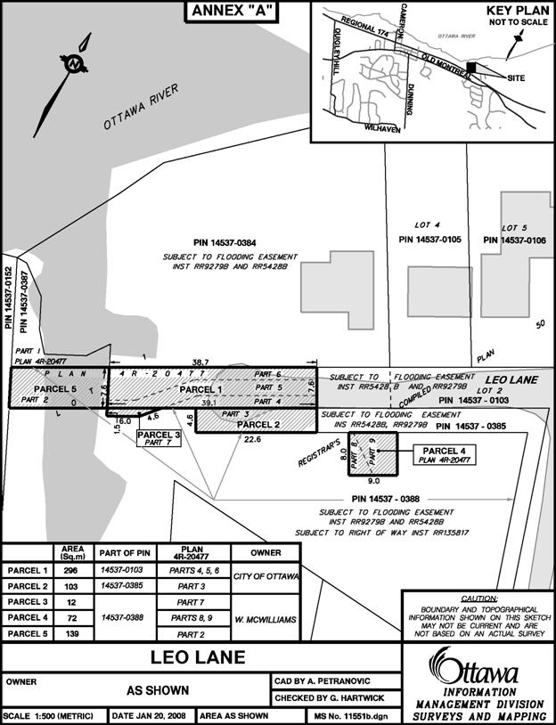
1. STREET CLOSURE - ROAD ALLOWANCE WEST PORTION OF LEO
LANE BETWEEN THE OTTAWA RIVER AND HIGHWAY 174 (PART OF LOT 1 ON PLAN 50 AND
PARTS 4, 5 AND 6 ON PLAN 4R-20477) FILE NO. D07-14-07-0009 FERMETURE DE RUE - EMPRISE
ROUTIERE PARTIE OUEST DE LA VOIE LEO ENTRE LA RIVIERE DES OUTAOUAIS ET
L'AUTOROUT 174 (PARTIE DU LOT 1 SUR LE PLAN 50 ET PARTIES 4, 5 ET 6 SUR LE
PLAN 4R-20477) |
Committee Recommendation
That Council approve a Street Closure application for the
lands legally known as Part of Lot 1 on Plan 50 and Parts 4, 5 and 6 on Plan
4R-20477, Former City of Cumberland, as shown in Document 1.
Recommandation du Comité
Que le Conseil approuve la
demande de fermeture de rue pour les terrains décrits au cadastre comme étant
une partie du lot 1 sur le Plan 50 et les parties 4, 5 et 6 sur le Plan
4R-20477, comme il est
indiqué dans le Document 1.
Documentation
1. Deputy City Manager's report
Infrastructure Services and Community Sustainability dated 6 November 2009
(ACS2009-ICS-PGM-0223).
2. Extract of Draft Minute, 26 November
2009.
Report
to/Rapport au :
Agriculture and Rural Affairs Committee
Comité de
l'agriculture et des affaires rurales
and Council / et au Conseil
06
November 2009 / le 06 novembre 2009
Submitted by/Soumis
par : Nancy Schepers, Deputy City
Manager/
Directrice municipale adjointe,
Infrastructure
Services and Community Sustainability/
Services d'infrastructure et Viabilité des
collectivités
Contact
Person/Personne-ressource : Derrick Moodie, Manager/Gestionnaire, Development
Review-Rural Services/Examen des projets d'aménagement-Services ruraux,
Planning and Growth Management/Urbanisme et Gestion de la croissance
(613) 580-2424,
15134 Derrick.Moodie@ottawa.ca
REPORT RECOMMENDATION
That the
Agriculture and Rural Affairs Committee recommend Council approve a Street
Closure application for the lands legally known as Part of Lot 1 on Plan 50 and
Parts 4, 5 and 6 on Plan 4R-20477, as shown in Document 1.
RECOMMANDATION DU RAPPORT
Que le Comité de
l’agriculture et des affaires rurales recommande au Conseil d’approuver la
demande de fermeture de rue pour les terrains décrits au cadastre comme étant
une partie du lot 1 sur le Plan 50 et les parties 4, 5 et 6 sur le Plan
4R-20477, comme il est indiqué dans le Document 1.
BACKGROUND
The subject lands are located at the west end of Leo
Lane between the Ottawa River inlet to the west and East Shore Road to the east
and are described as Part of Lot 1 on Plan 50, more particularly described as
Parts 4, 5 and 6 on Plan 4R-20477.
The purpose of the Street Closure is to reconvey the
untravelled portion of a road previously conveyed for the construction of a
turning circle to the original landowner.
The untravelled portion of Leo Lane subject to this
road closure was opened as a condition of a development agreement entered into
by the former City of Cumberland and the applicant (who owns the land to the
south of the road) in 1991. The
conveyance of the land from the applicant to the former City for the purpose of
providing a road widening along Leo Lane and a turning circle at the west end
of Leo Lane resulted in the creation of two lots located on either side of Leo
Lane.
The road was conveyed but never constructed, therefore
the City has agreed to allow a large driveway to be provided by the applicant
on the property on the south side of the existing roadway with an easement in
favor of the City. This would accommodate
City and emergency vehicles in replacement of the turning circle originally
agreed to in the 1991 development agreement.
This driveway will allow the vehicles to turn around and will eliminate
the need for the west portion of the road adjacent to the Ottawa River to be
constructed with a turning circle. The
City is therefore looking to dispose of the land and have it conveyed back to
the original landowner to the south.
DISCUSSION
The Official Plan does not designate this road
allowance as either a proposed or conceptual public road within Schedule G
(Rural Road Network). The subject road
allowance ends at the water's edge, property under which is privately owned and
therefore does not give access to public land. The lots abutting the existing
portion of Leo Lane to the north and south have sufficient frontage and area
with the existing road and therefore it is not necessary to open and construct
the balance of the road allowance.
The open, untravelled road allowance, is surplus to the needs of the City and access to the two lots on Leo Lane west of East Shore Lane is maintained. Conveying the land back to the original landowner to the south will result in increasing the lot area and make it more in conformity with the zoning requirements. Furthermore, this road allowance has not been identified in the Official Plan (Schedule G) as being a long-term potential or planned transportation corridor, thus there is no need to protect it for future use.
ENVIRONMENTAL IMPLICATIONS
This road closing would result in less road to maintain which
in turn signifies less salt use.
RURAL IMPLICATIONS
This road closing would result in a larger lot, thereby giving more flexibility to place the septic system and buildings outside of the floodplain. It would allow a more efficient layout to accommodate two new residences.
CONSULTATION
Notice of this application was carried out in accordance with the City's Public Notification and Consultation Policy. The Ward Councillor is in support of staff’s recommendation.
The residents on Leo Lane and East Shore Lane were circulated the application and the notice of intent to close. The property owners south of the road allowance subject to this road closure objected, stating that their right of way access is being removed. Evidence that a common right of way existed at one time giving the residents on both local roads access to the water's edge was provided during our process, however a title search by legal staff indicated that no such right of way is currently registered in favour of these residents.
A letter of objection received from Bell Baker further stated that the neighbouring residents have an issue with closing any portion of Part 1 on Plan 50R-6076 as it forms part of a separate right of way which was presumed transferred at the time the land was originally sold to the applicant. Title searches resulted in no right of way found in this location either. It was explained to the solicitor that in fact the legal description for the road closing was revised not to include any part which coincides with Part 1 on Plan 50R-6076 as it was owned by the applicant and not the City. Parts 4, 5 and 6 on Plan 4R-20477 are the only parts subject to the road closure.
COMMENTS BY THE WARD
COUNCILLOR
The
Ward Councillor is in support of the road closing.
LEGAL/RISK MANAGEMENT IMPLICATIONS
There are no legal/risk management implications associated with this report.
CITY STRATEGIC PLAN
N/A
TECHNICAL IMPLICATIONS
N/A
FINANCIAL IMPLICATIONS
N/A
APPLICATION PROCESS
TIMELINE STATUS
This application was
not processed by the "On Time Decision Date" established for the
processing of Street/Lane Closure applications.
The application has been objected to, thus requiring it to be brought
before the Agriculture and Rural Affairs Committee.
SUPPORTING DOCUMENTATION
DISPOSITION
City Clerk and Solicitor's Department, Legislative Services to notifiy the owner, OttawaScene.com, 174 Colonnade Road, Unit #33, Ottawa, ON K2E 7J5.