|
2. ZONING - 3661
GREENBANK ROAD ZONAGE -
3661, CHEMIN GREENBANK |
Committee recommendation as amended
(This matter is subject to Bill 51)
That Council approve an amendment
to the Zoning By-law 2008-250 to change the zoning of 3661 Greenbank Road from DR
- Development Reserve Zone to L2[1718]H(15) - Major Leisure Facility Zone
Exception 1718, R1Z - Residential First Density Zone, and R3Z[1677] -
Residential Third Density Sub Zone Z Exception 1677, as shown in Document 1 and
detailed in Document 2, as amended by the addition of the following
provision: “For that part of the property within 100.0 metres of the
east property line, the maximum building height is 11.0 metres.”
Recommandation modifÉe DU Comité
(Cette question est assujettie au Règlement 51)
Que le Conseil approuve une modification au Règlement de zonage 2008-250
afin de changer le zonage du 3661, chemin Greenbank de DR – Zone d’aménagement
futur à L2[1718]H(15) – Zone de grande installation de loisirs, exception 1718,
R1Z – Zone résidentielle de densité 1, et R3Z[1677] – Zone résidentielle de
densité 3, sous-zone Z, exception 1677, comme il est indiqué dans le Document 1
et expliqué en détail dans le Document 2, et telle que modifiée par l’ajout
de la clause suivante : « En ce qui a trait à la propriété située à
100 mètres de la ligne de propriété est, la hauteur maximale du bâtiment est
fixée à 11 mètres ».
Documentation
1.
Deputy
City Manager's report, Infrastructure Services and Community Sustainability,
dated 3 November 2009 (ACS2009-ICS-PGM-0211).
2. Extract of Draft Minutes, 24 November 2009.
Report to/Rapport au :
Planning
and Environment Committee
Comité de l'urbanisme et de l'environnement
and Council / et au Conseil
03 November 2009 / le 03 novembre 2009
Submitted by/Soumis par : Nancy Schepers, Deputy City Manager/Directrice municipale adjointe,
Infrastructure Services and Community
Sustainability/Services d’infrastructure et Viabilité des collectivités
Contact Person/Personne-ressource : Michael Wildman,
Manager/Gestionnaire, Development Review-Suburban Services/Examen des projets
d'aménagement-Services suburbains, Planning and Growth Management/Urbanisme et
Gestion de la croissance
(613) 580-2424, 27811 Mike.Wildman@ottawa.ca
|
SUBJECT: |
|
|
|
|
|
OBJET : |
REPORT RECOMMENDATION
That
the Planning and Environment Committee recommend Council approve an amendment
to the Zoning By-law 2008-250 to change the zoning of 3661 Greenbank Road from
DR - Development Reserve Zone to L2[1718]H(15) - Major Leisure Facility Zone
Exception 1718, R1Z - Residential First Density Zone, and R3Z[1677] -
Residential Third Density Sub Zone Z Exception 1677, as shown in Document 1 and
detailed in Document 2.
RECOMMANDATION DU
RAPPORT
Que le Comité de
l'urbanisme et de l'environnement recommande au Conseil d’approuver une
modification au Règlement de zonage 2008-250 afin de changer le zonage du 3661,
chemin Greenbank de DR – Zone d’aménagement futur à L2[1718]H(15) – Zone de
grande installation de loisirs, exception 1718, R1Z – Zone résidentielle de
densité 1, et R3Z[1677] – Zone résidentielle de densité 3, sous-zone Z,
exception1677, comme il est indiqué dans le Document 1 et expliqué en détail
dans le Document 2.
BACKGROUND
The subject lands are located east of Greenbank Road, between Cambrian Road and the southern extent of the Stonebridge development in the Barrhaven South Community. They represent the remaining undeveloped lands of the Stonebridge community. The 30-hectare vacant lands are part of the Stonebridge Phase 10 South, 11 and 12 subdivision. The subdivision was draft approved on March 26, 2009. Existing and planned residential developments surround the site with the exception of a block located in the northern portion of the subdivision, adjacent to the intersection of Greenbank Road and Cambrian Road, which is proposed for the development of a range of institutional uses including a recreational facility, school and emergency services.
Purpose of Zoning Amendment
The purpose is to rezone the land to accommodate residential and institutional development consisting of 320 single detached houses, approximately 180 townhouses and a range of leisure, recreational, culture and emergency service uses.
Existing Zoning
The subject site is currently zoned Development Reserve Zone (DR) under Zoning By law 2008-250. The purpose of the zone is to recognize lands intended for future urban development.
Proposed Zoning
The proposed zones are Major Leisure Facility Zone (L2[1718]H(15)) for the northern block to allow a range of institutional uses including a community centre, recreational and athletic facility, sports arena, park, school and fire station. Residential First Density Sub Zone Z (R1Z) is the zone proposed for the single detached houses and Residential Third Density Sub Zone Z Exception 1677 (R3Z[1677]) is the zone requested for the street townhouses.
DISCUSSION
The Official Plan designates the property General Urban Area. This designation permits the development of a full range of housing types to meet the needs of all ages and incomes, as well as conveniently located employment, retail, service, leisure and institutional uses.
The majority of the lands are located in the Jockvale Golf Community Secondary Plan - Area 13 except for the southerly portion of the lands, which are included in the more recently approved Barrhaven South Community Design Plan (CDP). Both these documents provide more detailed guidance regarding the form of development of the subject lands. With respect to the Jockvale Golf Community Secondary Plan - Area 13, the site is located on the western edge of Area 13 and the lands are predominantly designated Low-Medium Density Residential with the northern portion being designated as Institutional/Park. Under the Barrhaven South CDP the subject lands are designated Low and Medium Density Residential.
Details of Proposed Zoning
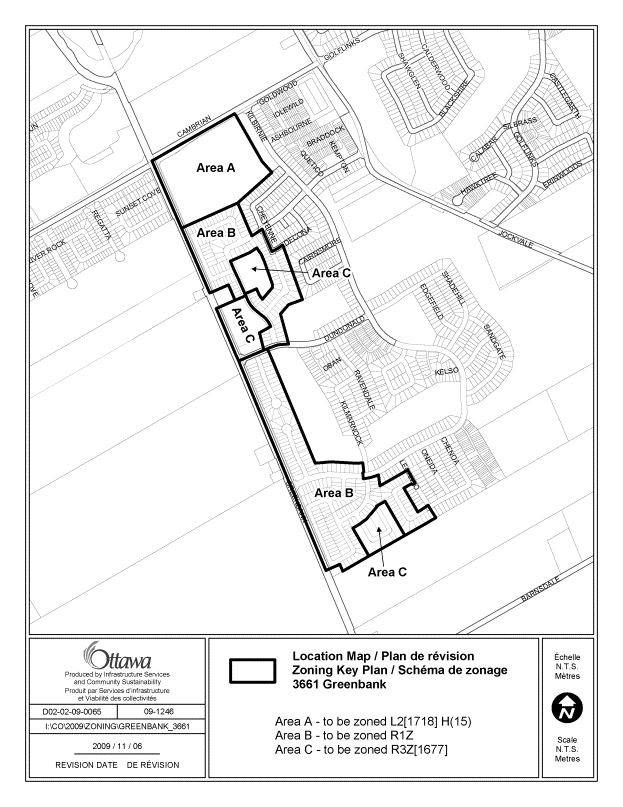
The proposed zoning for Area A, as shown on Document 1, is Major Leisure Facility Zone Exception 1718 (L2[1718]H(15)), which as previously indicated, permits a range of institutional uses. An exception provision is required to permit emergency services as an additional use as a fire station is proposed for the subject site. The suffix H(15) indicates a maximum building height of 15.0 metres.
The proposed zoning for Area B, the area of the single detached dwellings, is Residential First Density Sub Zone Z (R1Z), which permits only detached dwellings. It establishes a maximum building height of 11.0 metres, a minimum lot width of 9.0 metres and minimum lot area of 240 square metres. The proposed zoning for Area C is Residential Third Density Sub Zone Z Exception 1677 (R3Z[1677]). This zone permits detached, semi-detached and multiple attached dwellings. A Planned Unit Development (PUD), which is basically defined as two or more residential use buildings on the same lot with private roads as opposed to a public right of way, is also a permitted development and is proposed for the subject lands. Exception 1677 limits the minimum setback between the vehicular entrance to a private garage or carport and an existing or planned sidewalk to 6.2 metres. It also limits the maximum distance the front wall of a private garage may extend beyond building front wall, side wall, covered porch or veranda to 2.7 metres. This provision is in place in other phases of Stonebridge and is requested to be applied to the subject lands as well.
Analysis
The proposed zones are consistent with policies as outlined in the Official Plan, the Jockvale Golf Community Secondary Plan and the Barrhaven South CDP in that the new subdivision will provide for a range of housing options and institutional uses. The proposed residential zones are consistent with the zones that currently exist in other areas of the Stonebridge community. This will ensure that the unit mix and housing design will be similar throughout Stonebridge and allow for a harmonious transition across the community. The zones are appropriate in terms of the road configuration as per the plan of subdivision and proposed location of the institutional use area in the northern section of the plan.
The Department supports the application to amend the Zoning By-law as it advances residential and other key policies in the Official Plan and provides for a compatible residential subdivision.
RURAL IMPLICATIONS
N/A
CONSULTATION
Notice of this application was carried out in accordance with the City's Public Notification and Consultation Policy. The Ward Councillor is aware of this application and the staff recommendation. The City did not receive any negative comments or opposition to this application.
COMMENTS BY THE WARD COUNCILLOR
The Ward Councillor is aware of this application.
LEGAL/RISK MANAGEMENT IMPLICATIONS
There are no legal/risk management implications associated with this report.
CITY STRATEGIC PLAN
N/A
TECHNICAL IMPLICATIONS
N/A
FINANCIAL IMPLICATIONS
N/A
APPLICATION PROCESS TIMELINE STATUS
This application was processed by the "On Time Decision Date" established for the processing of Zoning By-law amendment applications.
SUPPORTING DOCUMENTATION
Document 1 Location Map
Document 2 Details of Recommended Zoning
DISPOSITION
City Clerk and Solicitor Department, Legislative Services to notify the owner, applicant, OttawaScene.com, 174 Colonnade Road, Unit #33, Ottawa, ON K2E 7J5, Ghislain Lamarche, Program Manager, Assessment, Financial Services Branch (Mail Code: 26-76) of City Council’s decision.
Planning and Growth Management to prepare the implementing by-law, forward to Legal Services and undertake the statutory notification.
Legal Services to forward the implementing by-law to City Council.
LOCATION
MAP DOCUMENT 1
DETAILS OF RECOMMENDED ZONING Document 2
Proposed Changes to the Comprehensive Zoning By-law
1. That the lands known municipally as 3661 Greenbank Road, shown as Areas A to C in Document 1, be rezoned as follows:
Area A from DR to L2[1718]H(15)
Area B from DR to R1Z
Area C from DR to R3Z[1677]
2. Area A, L2[1718]H(15)
A new exception, Exception 1718, be added to Section 239 to add emergency services as an additional permitted use.