|
2. Carleton Heights Area Traffic Management Study Étude De Gestion De La Circulation Locale De
Carleton Heights |
Committee Recommendations
That Council:
1. Approve the Carleton Heights Area Traffic Management Study
recommendations, as indicated in Documents 2 and 3.
2. Approve the implementation of the long-term measures shown
in Document 2 and, as described in this Report, subject to Council's future
approval of the necessary capital funding.
3. Approve the implementation of the immediate or interim work
shown in Document 3 and described in this Report.
Recommandations du comité
Que le Conseil :
1. approuve les recommandations de l’Étude de gestion de la
circulation de Carleton Heights, comme il est indiqué aux documents 2 et 3.
2. approuve la mise en œuvre des mesures à long terme énoncées
dans le document 2 et décrites dans le présent rapport, sous réserve de
l’approbation ultérieure des crédits nécessaires par le Conseil;
3. approuve la réalisation des travaux immédiats ou provisoires
énoncés dans le document 3 et décrits dans le présent rapport.
Documentation
1. Deputy City Manager’s report,
Infrastructure Services and Community Sustainability, dated 24 November 2009 (ACS2009-ICS-PGM-0226).
Report to/Rapport au:
Transportation Committee
and Council / et au Conseil
24 November 2009 / le 24 novembre 2009
Submitted by/Soumis
par: Nancy
Schepers, Deputy City Manager/Directrice municipale adjointe,
Infrastructure Services and Community Sustainability/Services
d’infrastructure et Viabilité des collectivités
Contact/Personne
ressource: Vivi Chi,
Manager/Gestionnaire, Transportation Planning/Planification des transports,
Planning and Growth Management/Urbanisme et Gestion de la croissance
(613)
580-2424 x 21877, Vivi.Chi@ottawa.ca
|
River (16) |
Ref N°: ACS2009-ICS-PGM-0226 |
|
SUBJECT: |
CARLETON HEIGHTS AREA TRAFFIC
MANAGEMENT STUDY |
|
|
|
|
OBJET: |
Étude de gestion de la
circulation locale dE Carleton heights |
REPORT RECOMMENDATIONS
That Transportation Committee recommend that Council:
1.
Approve
the Carleton Heights Area Traffic Management Study recommendations, as
indicated in Documents 2 and 3.
2.
Approve the
implementation of the long-term measures shown in Document 2 and, as described
in this Report, subject to Council's future approval of the necessary capital
funding.
3.
Approve the
implementation of the immediate or interim work shown in Document 3 and
described in this Report.
RECOMMANDATIONS DU RAPPORT
Que le Comité des transports
recommande au Conseil :
1.
D’approuver les recommandations de l’Étude de gestion
de la circulation de Carleton Heights, comme il est indiqué aux documents 2 et
3.
2.
D’approuver la mise en œuvre des mesures à long terme
énoncées dans le document 2 et décrites dans le présent rapport, sous
réserve de l’approbation ultérieure des crédits nécessaires par le Conseil;
3.
D’approuver la réalisation des travaux immédiats ou
provisoires énoncés dans le document 3 et décrits dans le présent rapport.
BACKGROUND
Residents in the Carleton Heights Community identified a number of
concerns regarding traffic operating conditions within their community. These concerns included speeding, aggressive
driving, and traffic volumes, due in part to through traffic in the
neighbourhood. A related issue dealt
with pedestrian safety both on the local streets, and while crossing the
adjacent arterial roads. Correspondence
and other communications between the community and the City regarding these
concerns have been ongoing for a number of years.
The Carleton Heights Area Traffic Management (ATM) Study was initiated
in July 2006, based largely on the above-noted concerns, and with the support
of the Ward Councillor. Concurrent with
the commencement of this study, concerns regarding traffic operating conditions
along Prince of Wales Drive and Fisher Avenue were also brought forward, and
the study boundaries were adjusted to include the consideration of both Prince
of Wales Drive and Fisher Avenue, as identified in Document 1.
The purpose of the ATM study was to quantify and assess the residents’
concerns, and to address those that were deemed to be appropriate issues to be
dealt with through the ATM process. This
was to be accomplished through the development of a Traffic Management Plan for
the Carleton Heights Community with the aim of mitigating identified issues
related to traffic flow and safety while balancing the desires of area
residents, pedestrians, cyclists and motorists.
DISCUSSION
The Carleton Heights Area Traffic Management Study was undertaken as a
“localized” ATM study covering the residential area bounded by Meadowlands
Drive, Prince of Wales Drive, and Fisher Avenue, within the River Ward 16 (see
Document 1). The study area is bounded
by two arterial roads to the east/ south and west, and a major collector road
to the north. The east-west collector in
the area is Falaise Road, and the north-south collector is Claymor Avenue, the
rest of the roads in the study area are local roads. The study area is predominately composed of
single-family residential homes situated on two-lane, two-way, rural
cross-section roads. Consistent with
City policy, there are sidewalks adjacent to the arterial and collector
roadways.
In addition to the concerns that were on file prior to the commencement
of the ATM study, one of the main purposes of both the first public working
group meeting and the first Public Open House was to confirm issues and give
area residents additional opportunities to raise issues for review. The ATM study is designed to be an open and
interactive process from the start to the finish. Input from the perspective of pedestrians,
cyclists, transit users, motorists, area residents and businesses was welcomed
throughout the study. In addition to the
Public Working Group (PWG) Meetings and Public Open Houses that were held as
part of this study, direct input to the study team was also encouraged via
email and telephone.
Based on the study process, staff reviewed concerns regarding vehicle
speeds and volumes, through traffic using neighbourhood roads, and pedestrian
safety issues. Staff assessed these
concerns using a number of data collection and analysis techniques, in addition
to on-going input from the area residents and Public Working Group
members. For concerns that were confirmed,
alternative solutions were developed for addressing these, while the results of
all concerns reviewed were reported back to the PWG and the public. An example of this is the issues that were
raised regarding the speed and volume of traffic on Falaise Road and Normandy
Crescent N. Based on speed surveys
and traffic counts conducted in 2008, it was determined that 85 per cent of the
vehicles surveyed were traveling at or below the posted speed limit. As well, an origin-destination survey was
also undertaken in order to quantify the amount and percentage of through
traffic using the neighbourhood streets.
While the percentage of vehicle trips that were confirmed as through
trips, in some cases, was relatively high, the overall traffic volumes on these
streets were found to be less than 100 vehicles per hour and therefore well
within acceptable volumes for a local road.
Recommendations
Following analysis of the data that was collected, and the review of the
feedback received from the public over the course of the study, the following
measures are recommended as a part of the Carleton Heights Area Traffic
Management Study.
Pedestrian Facilities/Sidewalks (see
Document 2)
- Normandy Crescent (N) from
Fisher Avenue to Prince of Wales Drive
- Normandy Crescent (S) from Prince of Wales Drive to Apeldoorn Avenue
- Apeldoorn Avenue from
Falaise Road to Normandy Crescent (S)
- Prince of Wales Drive,
east side between approximately 30 metres south of Nesbitt Place and Melfa
Crescent (South)
Reasons
The community, for the most part, is well
served with sidewalks and paths along Fisher Avenue and Prince of Wales Drive
(arterials) and along Falaise Road and Claymor Avenue (collectors). Concerns, however, were expressed regarding pedestrian
safety and the lack of sidewalks to accommodate the following:
·
Connectivity to Carleton Heights Community Centre from both Falaise Road and Normandy Crescent S
and from Prince of Wales Drive.
·
Normandy Crescent N is a local road that acts very much like a collector
similar to Falaise Road and is used by pedestrians to access Prince of Wales
Drive and Fisher Avenue where St. Rita Elementary School is located.
·
Along the east side of Prince of Wales Drive, between approximately 30
metres south of Nesbitt Place and Melfa Crescent S, the existing pedestrian
facility consists of only a painted road shoulder, which is shared with parked
vehicles and bicycles.
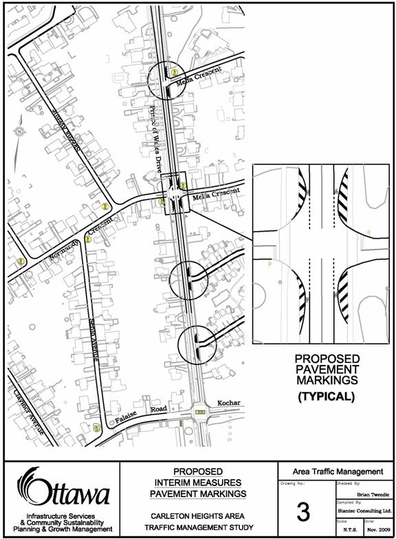
Pavement Markings Along Prince of Wales Drive (see
Document 3)
Delineate, via line painting and hatching, intersection narrowings to the
immediate north and south of each of the following roads where they intersect
with Prince of Wales Drive:
·
Melfa
Crescent N
·
Melfa
Crescent S
·
Normandy
Crescent N
·
Two
private road accesses between Kochar Drive and Melfa Crescent S
Reasons
The line painting, as identified in Document 3,
will provide additional information and guidance to road users regarding the
intended traveled lane locations versus the spaces for vehicle parking and
cycling. This is considered a short-term
solution, which can be readily accomplished through pavement markings. Following a monitoring period, staff will
determine the effectiveness of these measures and review the appropriateness of
permanent pavement narrowings along this corridor.
It must be emphasized that the subject roadway
modifications are conceptual and intended only to illustrate their proposed
function. The approval of any detailed
design of the roadway modification stemming from this report will be subject to
the City’s design review process.
Based on the City’s current prioritization and
budgeting procedures, it is likely that physical narrowings, if determined to
be warranted, would only be implemented at the time of roadway
reconstruction. Similarly, the sidewalks
identified in this study would likely be considered for implementation only at
the time of roadway reconstruction.
RURAL
IMPLICATIONS
N/A
CONSULTATION
The
Public Working Group for this study was comprised of nine individuals from
across the community.
Two PWG meetings
were held on the following dates, both of which exhibited a high level of
attendance and participation:
·
PWG Meeting 1: Tuesday,
Nov. 27, 2007 at Carleton Heights Community Centre
·
PWG Meeting 2: Thursday,
Nov. 20, 2008 at Carleton Heights Community Centre
Two Public Open
Houses (POH) were held as part of this study, both at the Carleton Heights
Community Centre at 1665 Apeldoorn Avenue, on the following dates:
·
POH 1: Monday,
December 17, 2007 (59 attendees, 23 comment sheets)
·
POH 2: Thursday,
May 7, 2009 (35 attendees, 14
comment sheets)
The first POH was focused on introducing the project, outlining the
study process, and discussing the information that had been collected to that
point. The attendees confirmed the issues identified along the corridor and
provided additional comments regarding supplemental concerns.
The second POH
provided confirmation of the study objectives and scope, summarized the
identified concerns, and presented illustrations of the proposed ATM
measures. In many cases, concerns that
had been previously identified were found to be either not suitable or of
adequate severity to require ATM measures.
The attendees provided feedback on the various measures proposed. In general, most of the major concerns were
considered to be adequately addressed.
In some cases, modifications or variants to the proposed concept plan
were discussed.
Notices for both
POHs were published in daily and community papers including the Ottawa Citizen,
and Le Droit. In addition, flyers were
distributed door-to-door within the study area in advance of each of the two
POHs.
COMMENTS
BY THE WARD COUNCILLOR(S)
The Ward Councillor is aware of this report.
LEGAL/RISK MANAGEMENT IMPLICATIONS
There are no legal/risk management impediments to the implementation of this report's recommendations.
CITY
STRATEGIC PLAN
A1 Improve the City’s transportation network to afford ease of
mobility, keep pace with growth, reduce congestion and work towards modal-split
targets.
TECHNICAL
IMPLICATIONS
N/A
FINANCIAL IMPLICATIONS
The interim measures recommended in this report (pavement marking on
Prince of Wales Drive) can proceed once approved, with funding provided through
existing Operating Accounts (Public Works).
The capital cost associated with implementing the remaining recommendations
of this ATM plan is estimated to be in the order of $745,000. If approved, these measures would be placed
on the waiting list of approved ATM measures for future implementation. Funding for the implementation of these
remaining Area Traffic Management measures will be subject to annual budget
deliberations, and either funded as an Area Traffic Management project within
the Capital Budget, or included as part of a future roadway reconstruction
project.
SUPPORTING DOCUMENTATION
Document 1 Location
Plan – Carleton Heights Area Traffic Management Study
Document 2 Recommended
Measures - Carleton Heights Area Traffic Management Study
Document 3 Recommended Interim Measures - Carleton
Heights Area Traffic Management Study
DISPOSITION
Staff of the Transportation Planning Branch will proceed with
implementation of the approved measures based on established design and
prioritization/funding procedures.
LOCATION MAP –
CARLETON HEIGHTS AREA TRAFFIC
MANAGEMENT STUDY DOCUMENT 1

RECOMMENDED MEASURES -
CARLETON HEIGHTS AREA
TRAFFIC MANAGEMENT STUDY DOCUMENT 2
RECOMMENDED
INTERIM MEASURES - CARLETON HEIGHTS
AREA TRAFFIC MANAGEMENT STUDY DOCUMENT 3