|
3. Ottawa Road 174 - In-Service Road
Safety Review Route 174 - Examens De La Sécurité Des
Routes En Service |
Committee Recommendations As
Amended
That
Council approve:
1. That staff implement all short-term
strategies identified in the report along the two-lane arterial road segment of
Ottawa Road 174 east of Trim Road and that this work be completed within
current budgeted programs.
2. That staff undertakes a preliminary
design of geometric improvements at the intersection of Ottawa Road 174 and
Quigley Hill Road and that funds for the construction of these geometric
improvements be requested in future capital budgets.
3. That Infrastructure Services staff be
directed to design and construct the extension of the transition zone from the
freeway section to the two-lane rural arterial road segment including the
installation of street lighting, as shown in Document 4 and to increase the
base budget of the Trim Road Widening (Ottawa Road 174 to Frank Kenny) project
from $ 29.3 million to $ 35 million to fund in the 2011 capital budget.
4. That funding required to implement all
medium-term strategies identified in the report be included for consideration
in future capital budgets, and
5. That the City request funds from the
province and the federal government to implement the road safety strategies
included in the report.
6. That the City once again request the
Government of Ontario to conduct an Environmental Assessment on widening the
road.
Recommandations modifiées du comité
Que le Conseil approuve ce qui
suit :
1. Que le personnel mette en œuvre toutes les stratégies à
court terme désignées dans le rapport et s’appliquant au tronçon d’artère à
deux voies de la route 174 à l’est du chemin Trim, et qu’elles soient mises en
œuvre dans le cadre des programmes budgétisés actuels.
2. Que le personnel entreprenne la conception préliminaire des
améliorations géométriques à l’angle de la route 174 et du chemin Quigley Hill,
et que les fonds nécessaires à ces travaux d’amélioration géométrique soient
requis sous la forme dans les prochains budgets d’investissement.
3. Que le personnel des Services d’infrastructure soit chargé
de concevoir et de réaliser le prolongement de la zone de transition entre le
tronçon d’autoroute et celui d’artère rurale à deux voies, y compris
l’installation de lampadaires, tel qu’illustré dans le Document 4, et que la
demande d’accroissement du budget de base du projet d’élargissement du chemin
Trim (de la route 174 à Frank Kenny), de 29,3 millions de dollars à 35 millions
de dollars, soit faite dans le cadre du budget d’investissement de 2011.
4. Que le financement nécessaire à la mise en œuvre de toutes
les stratégies à moyen terme désignées dans le rapport soit pris en compte dans
les prochains budgets d’investissement.
5. Que la Ville demande aux gouvernements provincial et fédéral
les fonds nécessaires à la mise en œuvre des stratégies de sécurité routière
décrites dans le rapport.
6. Que
la Ville redemande au gouvernement de l’Ontario de mener une évaluation environnementale
concernant l’élargissement du chemin.
Documentation
1. Deputy City Manager’s report, City
Operations, dated 29 October 2009 (ACS2009-COS-PWS-0024).
2. Extract of Draft Minute, 2 December
2009
Report to/Rapport au:
Transportation Committee
Comité des transports
and Council/et Conseil
29 October 2009
/ 29 octobre 2009
Steve Kanellakos, Deputy City
Manager/Directeur municipal adjoint
City Operations/Opérations municipales
Contact
Person/Personne ressource:
John
Manconi, General Manager/directeur général, Public Works/TravauxPublics
613-580-2424, extension 21110,
John.Manconi@ottawa.ca
|
Ref N°: ACS2009-COS-PWS-0024 |
|
SUBJECT: |
OTTAWA ROAD 174 - In-Service Road
Safety Review |
|
OBJET: |
ROUTE 174 - Examens de la sécurité des Routes en Service |
REPORT
RECOMMENDATIONS
That
Transportation Committee recommend that Council approve:
1.
That staff implement all short-term strategies
identified in the report along the two-lane arterial road segment of Ottawa
Road 174 east of Trim Road and that this work be completed within current
budgeted programs.
2.
That staff undertakes a preliminary design of
geometric improvements at the intersection of Ottawa Road 174 and Quigley Hill
Road and that funds for the construction of these geometric improvements be
requested in future capital budgets.
3.
That Infrastructure Services staff be directed
to design and construct the extension of the transition zone from the freeway
section to the two-lane rural arterial road segment including the installation
of street lighting, as shown in Document 4 and to increase the base budget of
the Trim Road Widening (Ottawa Road 174 to Frank Kenny) project from $ 29.3
million to $ 35 million to fund in the 2011 capital budget.
4.
That funding required to implement all
medium-term strategies identified in the report be included for consideration
in future capital budgets, and
5.
That the City request funds from the province
and the federal government to implement the road safety strategies included in
the report.
RECOMMANDATIONS DU RAPPORT
Que le Comité des transports
recommande au Conseil d’approuver ce qui suit :
1.
Que le personnel mette en œuvre toutes les stratégies à court terme
désignées dans le rapport et s’appliquant au tronçon d’artère à deux voies de
la route 174 à l’est du chemin Trim, et qu’elles soient mises en œuvre dans le
cadre des programmes budgétisés actuels.
2.
Que le personnel entreprenne la conception préliminaire des améliorations
géométriques à l’angle de la route 174 et du chemin Quigley Hill, et que les
fonds nécessaires à ces travaux d’amélioration géométrique soient requis sous
la forme dans les prochains budgets d’investissement.
3.
Que le personnel des Services d’infrastructure soit chargé de concevoir
et de réaliser le prolongement de la zone de transition entre le tronçon
d’autoroute et celui d’artère rurale à deux voies, y compris l’installation de
lampadaires, tel qu’illustré dans le Document 4, et que la demande d’accroissement
du budget de base du projet d’élargissement du chemin Trim (de la route 174 à
Frank Kenny), de 29,3 millions de dollars à 35 millions de dollars, soit faite
dans le cadre du budget d’investissement de 2011.
4.
Que le financement nécessaire à la mise en œuvre de toutes les
stratégies à moyen terme désignées dans le rapport soit pris en compte dans les
prochains budgets d’investissement.
5.
Que la Ville demande aux gouvernements provincial et fédéral les fonds
nécessaires à la mise en œuvre des stratégies de sécurité routière décrites
dans le rapport.
EXECUTIVE SUMMARY
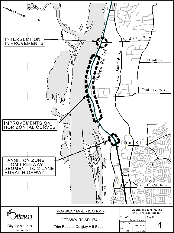
In 1997, Ottawa Road 174 (OR 174), formerly provincial Highway 17, became the responsibility of the City of Ottawa (formally RMOC). The OR 174 In-Service Road Safety Review (ISRSR) study area comprises the two-lane rural arterial road section of OR 174 from Trim Road intersection up to the City limits east of the Canaan Road intersection, as shown in Document 1.
The objective of the OR 174 safety study was to analyze the existing
road safety performance of this 12.7 kilometre section, and identify a set of
cost-effective strategies that would improve both the road safety and
operational performance of this roadway segment.
The study followed the principles and tasks
outlined in "The Canadian Guide to In-Service Road Safety Reviews"
(2004 Edition) produced by the Transportation Association of Canada (TAC). This
engineering study is an
independent and formal process conducted by a team of road safety experts who,
based upon experience and expertise, can provide opinions on road safety
matters from the perspective of the road users and identify cost-effective road
safety recommendations that would improve the traffic safety conditions of a
roadway facility.
A total
of 270 collisions reported between January 1, 2003 and December 31st,
2007 were reviewed at intersections and road segments in between intersections
(mainline segments), as shown in Document 2.
Over the study period, 5 fatal collisions occurred on the corridor,
collisions resulting in injuries (52) represented 19% of all collisions and 80%
(213) of all collisions resulted in Property Damage Only (PDO). The total societal economic impact due to
collisions was estimated close to $84.4 million in 2008 figures. A total of 1,294 offence
notices were issued during the five-year period (2003-2007). Significant Highway Traffic Act (HTA) offences included
speeding (475), careless driving (51), and following too close (34).
Staff reviewed the study findings to prepare a road safety implementation plan, which is expected to be cost effective in reducing the risk of collisions resulting in injury and/or fatal collisions along the corridor.
The plan presents both the short-term and medium-term strategies. Strategies are also broken into groups that
address corridor-wide concerns and localized concerns impacting the vicinity of
the Cameron Street intersection, as well as the intersection with Trim Road.
The short-term strategies include:
upgrade signs and pavement markings, improve roadway surface along the
corridor, install centreline rumble strips, develop a roadside design study,
conduct a speed zone review, upgrade traffic operations and roadway geometry,
and provide illumination at unsignalized and signalized intersections within
the corridor, continue education and enforcement campaigns, and continue to
monitor the collisions along the corridor.
The medium-term strategies include: improve the roadside environment,
upgrade traffic operations and roadway geometry at unsignalized intersections,
develop and implement an access management strategy and improve roadway surface
along the corridor.
The implementation of the short-term strategies already started this
past summer with the installation of the traffic control signal at Canaan and
OR 174 and the microsurfacing of the easterly portion of OR 174. It is expected that all short-term
strategies, except for the work near the Trim Road intersection (to be
coordinated with Trim Road Widening project), will be implemented by 2011. The medium-term strategies would require a
further engineering study before deciding the implementation period and they
would likely require a staged implementation due to funding pressures.
RÉSUMÉ
En 1997,
la route 174, anciennement l’autoroute provinciale 17, tombait sous la
responsabilité de la Ville d’Ottawa (anciennement la MROC). Le secteur d’étude de l’Examen de sécurité
visant la route 174 comprend le tronçon d’artère rurale à deux voies de la
route 174 situé entre le chemin Trim et les limites de la Ville à l’est du
chemin Canaan, tel qu’illustré dans le Document 1.
L’examen de sécurité visant la route 174 avait
pour objet d’analyser le rendement en matière de sécurité routière sur ce
tronçon de 12,7 kilomètres, et de désigner une série de stratégies rentables
susceptibles d’améliorer la sécurité routière et le rendement opérationnel de
ce tronçon.
L’examen a été mené
conformément aux principes et à la mission énoncés dans le Guide canadien des examens de la sécurité des routes en
service (édition de 2004), publié par l’Association des transports
du Canada (ATC). Cette étude
technique a été réalisée de manière indépendante et officielle par une équipe
d’experts en sécurité routière qui, grâce à son expérience et à son expertise, peut donner son opinion sur
des questions de sécurité routière du point de vue de l’usager de la route, et
faire des recommandations rentables de sécurité routière susceptibles
d’améliorer les conditions de sécurité sur une route en particulier.
Au total, 270 collisions signalées entre le 1er
janvier 2003 et le 31 décembre 2007 ont été examinées à des intersections et
sur des tronçons situés entre des intersections (tronçons principaux), tel
qu’illustré dans le Document 2. Au cours
de la période d’examen, 5 accidents mortels se sont produits dans ce couloir;
les collisions avec blessés (52) ont représenté 19 pour cent de toutes les
collisions et 80 pour cent (213) des collisions n’ont entraîné que des dommages
matériels. L’incidence sociétale et économique globale
attribuable aux collisions a été estimée à près de 84,4 millions de dollars en
2008. Au total, 1 294 contraventions ont été données au cours de la période
2003-2007. Les excès de vitesse (475),
la conduite imprudente (51) et le talonnage (34) figuraient parmi les
infractions les plus fréquentes au Code de la route.
Le personnel a examiné les conclusions de
l’examen afin de préparer un plan de mise en œuvre de sécurité routière, qui
devrait s’avérer rentable en réduisant dans ce couloir le risque de collisions
mortelles ou avec blessés.
Ce plan propose des stratégies à court et à
moyen terme. Les stratégies ont été
partagées en groupes portant sur les problèmes de largeur du couloir et les
problèmes localisés ayant des répercussions autour de l’intersection de la rue
Cameron et celle du chemin Trim.
Mentionnons parmi les stratégies à court terme
l’amélioration des panneaux indicateurs et des marques sur la chaussée,
l’amélioration de la chaussée dans le couloir, l’installation de ralentisseurs
sonores sur la ligne médiane, l’élaboration d’une étude de conception des
accotements, l’examen d’une zone de limitation de vitesse, l’amélioration de la
circulation et de la géométrie de la chaussée, l’installation de lampadaires
aux carrefours équipés ou non de feux de circulation du couloir, la poursuite
des campagnes de sensibilisation et d’application des règlements, et la
poursuite de la surveillance des collisions dans le couloir.
Les stratégies à moyen terme comprennent
l’amélioration des accotements, l’amélioration de la circulation et de la
géométrie de la chaussée aux carrefours sans feux de circulation, l’élaboration
et la mise en œuvre d’une stratégie de gestion des accès, et l’amélioration de
la surface de la chaussée dans le couloir.
La mise en œuvre des stratégies à court terme a
déjà été lancée avec l’installation du feu de circulation à l’angle de Canaan
et de la route 174, et le microsurfaçage du tronçon est de la route 174,
effectués l’été dernier. Toutes les stratégies
à court terme, sauf les travaux à proximité de l’intersection du chemin Trim
(qui doivent être coordonnés avec le projet d’élargissement du chemin Trim)
devraient être mises en œuvre d’ici à 2011.
Les stratégies à moyen terme doivent faire l’objet d’une autre étude
technique avant que ne soit décidée la période de mise en œuvre. Ces stratégies devraient en outre faire
l’objet d’une mise en œuvre par étapes en raison des contraintes de
financement.
BACKGROUND
The physical characteristics and environment of OR 174 are unique within
the City road network. In the past, this roadway was the main connection
between Ottawa and Montreal. Since the opening of Highway 417, the road is
mainly used by commuters and local residents, with some through traffic coming
from the City of Clarence-Rockland and the Masson (Quebec) ferry’s users. Also,
it crosses Cumberland Village and the growing suburban areas connected to OR
174.
The objective of this study was to analyze the existing road safety
performance of this 12.7 kilometre section, and identify a set of
cost-effective strategies that would improve both the road safety and
operational performance of this roadway segment.
As mentioned above, OR 174 is a legacy facility from the province. As
such, the road safety study (ISRSR) was conducted using engineering
methodologies applicable to the existing conditions of a two-lane rural highway
road cross-section. The study followed
the principles and tasks outlined in "The Canadian Guide to In-service
Road Safety Reviews" (2004 Edition) produced by the Transportation
Association of Canada (TAC).
This engineering study is an independent and formal process conducted by a
team of road safety experts who, based upon experience and expertise, provide
opinions on road safety matters from the perspective of the road users and
identify cost-effective road safety recommendations that would improve the
traffic safety conditions of a roadway facility.
Following the TAC guidelines, the City retained a consultant to
undertake the OR 174 In-Service Road Safety Review (ISRSR). The study has allowed the City to develop a
comprehensive understanding of the safety challenges and opportunities that
exist, or are perceived to exist, within the OR 174 two-lane road segment.
The outcome of the field observations and analysis of the data used for
the capacity operational and safety review are summarized in the following
section. Also, a road safety
implementation plan that would improve the traffic safety performance on the
corridor is outlined.
DISCUSSION
The OR 174 two-lane rural highway segment largely operates under congested
conditions during the morning and afternoon peak period times on any given
weekday. The traffic record indicates
that the Average Daily Volume (AADT) is close to 19,000 vehicles. In theory, a highway facility such as this
segment of OR 174 has a capacity to carry 20,000 vehicles. Within the current
geometric configuration, this road has limited capacity to absorb any
additional traffic. Furthermore, in recent years the number of collisions reported
on this facility has increased.
In addition to the entire two-lane corridor of OR 174 between Trim Road
and Canaan Road (the City limit), the safety study considered a short distance
of the connecting roads to OR 174 within the study area, as shown in Document
1.
The study process included data analysis and field observations in order
to determine the existing road safety and operational performance of OR 174
two-lane rural highway segment. A
systematic approach “lines of evidence” was followed for both the road safety
engineering and the capacity operational analyses. The “lines of evidence” approach examines a
range of factors that may be related to collision overall safety performance. These are assessed first individually, and
then as a whole.
“Where lines of evidence “overlap” and point to a common conclusion
regarding a particular feature or element of the roadway, that conclusion is
strengthened by the independence of the indicators and the multiplicity of
their occurrence as well as the independence of the individual investigators
pursuing the different approaches to the analysis”.
This approach included the application of five different examination
methods:
·
MTO’s
“Science of Highway Safety”- Operational Performance Functions (OPF);
·
Collision
pattern analysis;
·
Field
investigation;
·
Traffic
operational review; and,
·
Interactive
Highway Safety Design Model (IHSDM).
ROAD SAFETY FINDINGS
The road safety analysis identified collision
patterns, locations, the degree to which existing traffic conditions would
impact the risk of collision frequency and the potential for traffic
operational improvements.
A total of 270 collisions reported between January 1, 2003 and December 31st, 2007 were reviewed at intersections and road segments between intersections (mainline segments), as shown in Document 2. Over the study period, 5 fatal collisions occurred on the corridor, collisions resulting in injuries (52) represented 19% of all collisions and 80% (213) of all collisions resulted in Property Damage Only (PDO). Of the 270 collisions, 100 collisions (37%) occurred during periods of reduced lighting.
The following
information highlights the results of the five-years collision analysis along
OR 174 road segments between intersections (mainline segments) and at
intersections.
Mainline Segments
A total of 174 collisions were reported on the mainline segments and the typical patterns are:
· 56 Rear-end collisions (32% of total);
· 48 Run-off-road collisions (27% of total);
· 41 Animal related collisions (23% of total).
The road safety analysis indicated that the highest collision numbers in the study area occurred in two consecutive road segments:
|
Quigley Hill Rd - Cameron St (31 collisions) The typical patterns are: |
|
|
· 12 Rear-end collisions (19% of total) · 20 Run-off-road collisions (32% of total) · 14 Animal related collisions (22% of total) · Of the 63 collisions, 38% occurred during periods of reduced lighting · Of the 63 collisions, 2 fatal collisions and12 resulted in injury (19% of total) |
· 14 Rear-end collisions (45% of total) · 7 Run-off-road collisions (23% of total) · 5 Animal related collisions (16% of total) · Of the 31 collisions, 48% occurred between 4:00 pm and 7:00 pm · Of the 31 collisions, 1 fatal collision and 7 resulted in injury (23% of total) |
The collision analysis at intersections indicated the following results:
Signalized
Intersections
A total of 57 collisions occurred at the Trim Road intersection and the typical patterns are:
· 33 Rear-end collisions (58%);
· 9 Run-off-road and single vehicle collisions (16%);
·
6 Left
turn movement collisions (11%).
Property damage only (PDO) collisions are over-represented at this
intersection (45 collisions).
Of the 57 collisions, 40% occurred during periods of reduced lighting.
A total of 21 collisions was reported at the Cameron Street intersection
and the majority (57% of total) were rear-end collisions. This could be associated to the congested
conditions during the peak morning and afternoon time.
Unsignalized
Intersections
A total of 17 collisions were reported at the non-signalized intersections and the typical patterns are:
· 8 Rear-end collisions (47%);
· 5 Run-off-road and single vehicle collisions (29%);
·
2 Left
turn movements (12%).
One fatal collision was reported at Old Montreal Road West (Kinsella
Drive). Of the 17 collisions, 24% occurred during periods of reduced lighting.
Societal Economic
Impact
During the study period (2003-2007), the total societal economic impact
due to collisions was estimated close to $84.4 million in 2008
figures. The cost estimation amount was
based on the “Willingness-to-Pay” figures provided by the 2007 MTO-Transport Canada document “Analysis
and Estimation of the Social Cost of Motor Vehicle Collisions in Ontario –2004”
and the 2004 values provided in the document have been inflated with a CPI of
2.4%.
Offence Notices
In addition to the collision data, the Ottawa Police Service made
available a list of all offence notices issued to motorists within the study
corridor. A total of 1,294 offence notices were issued during the five-year
period (2003-2007). Significant Highway
Traffic Act (HTA) offences included speeding (475), careless driving (51),
and following too close (34).
Traffic Engineering Review
In summary, the
following key factors may have impacted the five-year collision history on OR
174 from Trim Road to the City boundary:
Speed: Based on the 85th percentile, operating speeds on this facility range from 95 - 104 km/h on roadway segments posted at 90 km/h to 95 – 99 km/h on roadway segments posted at 80 km/h.
Roadside environment: The roadside environment on a roadway and its design has an important role to play in improving road safety. For instance, roadside fixtures, such as culverts or rock outcroppings, can present a serious safety problem for vehicles if left unprotected.
Accesses: Within the study area, the frequency of residential driveways and minor intersection accesses on both sides of OR 174 create a significant impact on the roadway operation. This does not only result in reduced traffic capacity but also tends to increase vehicle conflicts and delays along the facility. In particular, these concerns were noted in the vicinity of the Cameron Street intersection. The existence of substantive speed differentials and the willingness of drivers to accept smaller gaps in the through traffic stream when entering the roadway may have an impact on traffic safety.
Illumination: Large sections of the mainline are not illuminated. This may contribute to increased collisions during reduced light levels with vehicles accessing or egressing driveways and accesses and the increase in animal related collisions.
Positive guidance: A number of concerns associated with the condition of the signage on this facility were identified. For example: the retro-reflective properties for each sign needs to be assessed and non-standard and\or faded signs should be removed or replaced.
Passing opportunities: Although there are passing opportunities along OR 174, the consistent long vehicle platoon lengths observed on the road suggest that they are not making a positive impact in the traffic flow during morning and afternoon peak hour periods.
Level of service (LOS): The outcome of the capacity operational analysis suggests that the corridor operates at LOS E – at capacity – in both directions during both morning and afternoon peak periods. In some cases, the capacity of a roadway can be improved by adding passing lanes. Typically, the criterion for the need for passing lanes is based on maintaining an acceptable level of traffic operation (LOS C). Nonetheless, a passing lanes analysis was conducted along OR 174 and the results confirmed that they are not suitable for this roadway within the current geometric configuration and traffic operation conditions.
The intersection geometry and operations: There were several concerns regarding the existing intersection geometry and operations. In particular, Cameron Street intersection capacity analysis indicates that the intersection operates at congested conditions (LOS D). Also, other intersection geometry issues were identified including the length of transition tapers for left–turn bypass lanes, short and narrow auxiliary lanes, the absence of auxiliary lanes at some intersections and excessive queue lengths during peak hour periods.
Trim Road and OR 174 - intersection operations: This intersection consists of an isolated traffic signal located at the end of a higher-speed four-lane divided freeway that transitions to a two-way two-lane rural highway cross section. The queue of eastbound vehicles turning right at Trim Road extends into the high-speed through lanes of OR 174 during the PM peak hour period. The risk of high-speed end of queue collisions is of particular concern at this location. Also, the risk of collisions extends to the transition zone on the eastbound direction, which ends on a sharp curve.
Potential Opportunities for Improvement
Given the complexity of the corridor,
the study included the development of Operational
Performance Functions (OPF) using the parameters of the Province of
Ontario. The purpose of the OPF is to
evaluate the current safety performance by developing estimates of the
“expected” safety performance of typical types of roads and intersections in
the Province of Ontario. The result of
this analysis is expressed by using the Potential for Operational Improvement
(POI) index.
The POI ranking provided the City with guidance on the priority that should
be assigned to a location of interest or to address the safety deficiencies on
the roadway element. The ranking of the
mainline segments and signalized intersections are shown on Table 1.
Table 1: Road Segments and Signalized
Intersections POI raking
|
Locations |
|
Rank |
Mainline Segments
|
Length
|
|
|
Quigley
Hill Rd to Cameron St |
(1.4km) |
1 |
|
McTeer
Rd to Canaan Rd |
(0.9km) |
2 |
|
Trim
Rd to Quigley Hill Rd |
(5.0km) |
3 |
|
Morin
Rd to Old Montreal Rd West (Kinsella Drive) |
(0.4km) |
4 |
|
Old
Montreal Rd East to McTeer Rd |
(0.2km) |
5 |
|
Faubert
St to East St\Peter Harkness Lane |
(0.1km) |
6 |
|
West
St to Faubert St |
(0.1km) |
7 |
|
Cameron
St to West St |
(0.1km) |
8 |
|
East
Shore Lane to Morin Rd |
(0.2km) |
9 |
|
East
St\Peter Harkness Lane to East Shore Lane |
(1.2km) |
10* |
|
Old
Montreal Rd West (Kinsella Drive) to Old Montreal Rd East |
(2.0km) |
10* |
|
Signalized Intersections |
|
|
|
Trim Road
Signalized Intersection |
|
1 |
|
Cameron
Street Signalized Intersection |
|
2 |
|
* POI
indicated equal value |
|
|
Road Safety Strategies
Based on
the analysis above, a series of candidate countermeasures were selected on the
basis of the likelihood of reducing the frequency of collisions, the severity
of collisions, or both. The evaluation
process continued by quantifying the potential road safety and operational
benefits associated with each of the selected countermeasures. Given the diverse nature of these
countermeasures, a toolset of safety analysis techniques were applied. Also, a construction cost estimate for the
implementation of each countermeasure was prepared to advance the opportunities
to implement them.
After this analysis was completed, it was evident that there are
opportunities for safety and traffic operational improvements in the OR 174
corridor for the short and mid term periods.
The strategies were analyzed into four distinct categories:
·
Corridor-wide
strategies: these strategies included countermeasures that are applicable to
the corridor level or the great majority of the study area;
·
Unsignalized
intersection strategies: these strategies are expected to improve the safety
and operation of selected locations along the corridor;
· Trim
Road and OR 174 intersection and transition zone strategies: these strategies
are expected to address the traffic operational concerns of the intersection in
conjunction with reducing the risk of collision in the transition zone (from
the freeway section to the two-lane rural arterial
road segment) of OR 174; and,
· Cameron Street intersection and Cumberland
community strategy: these strategies are expected to improve the safety and
operation of this road segment.
These strategies have been evaluated individually; opportunities for
combining the various countermeasures for implementation are recommended. A benefit/cost ratio (B/C) value was
calculated based on the expected safety performance of each strategy (including
collision history and expected collision reduction). For example at the corridor level, installing
centerline rumble strips has a B/C of 365, geometric improvements shows a B/C
of 18 and a capacity upgrade strategy shows a B/C of 1 or less than 1. The higher the number, the greater is the
potential benefit contrary to a B/C of 1 or less than 1, which is very
marginal.
For the safety study and the existing condition of the OR 174 corridor,
this approach is appropriate in order to assess the potential road safety
benefit as a direct result of implementing a specific strategy. Also, it allows prioritization guidance on
candidate safety strategies for implementation based on their safety
effectiveness. The following sections
discuss further the proposed road safety strategies and the implementation
plan.
ROAD SAFETY IMPLEMENTATION PLAN
Following the three E’s of road safety, engineering, enforcement and
education, staff prepared a road safety implementation plan, which is expected
to be cost effective in reducing the risk of collisions resulting in injury
and/or fatal collisions. An innovative
safety analysis procedure was applied to prioritize the candidate strategies
and those with the highest potential of reducing the risk or severity of
collisions were selected for implementation in the short-term period.
The plan is summarized in Table 2 and presents both the short-term and
medium-term strategies. Also, strategies are broken into groups that address
corridor-wide concerns and localized concerns impacting the vicinity of the
Cameron Street intersection, as well as the intersection with Trim Road.
Table 2: Road
Safety Implementation Plan
|
COUNTERMEASURES |
IMPLEMEN-TATION
YEAR |
Est. Cost ($000) |
Funded Y/N |
|
SHORT
-TERM STRATEGIES |
|
|
|
|
Corridor-Wide |
|
|
|
|
Upgrade traffic operations at unsignalized intersection: Installing a new traffic signal at the Canaan Road intersection |
Completed - 2009 |
N/A |
N/A |
|
Improve roadway surface – microsurfacing from 300 m east of Cameron Street to the City boundary |
Completed - 2009 |
N/A |
N/A |
|
Upgrade signage and pavement markings |
2010/2011 |
100 |
2010 budget |
|
Install centreline rumble strips |
2010 |
20 |
Y |
|
Increase the pavement width on horizontal curves west of the intersection with Quigley Hill Road |
2010 |
230 |
Y |
|
2010 |
75 |
2010 budget |
|
|
Upgrade the intersection geometry at unsignalized intersection: Conducting a preliminary design to provide left turn lanes at the Quigley Hill Road intersection |
2010 |
30 |
Y |
|
Provide illumination at unsignalized intersections |
2010/2011 |
125 |
Y |
|
Conduct a corridor wide speed zone review |
2011 |
Internal |
Y |
|
Continue education and enforcement campaigns |
Annual |
Internal |
Y |
|
Annual |
Internal |
Y |
|
|
Cameron
Street Intersection and Cumberland Village |
|
|
|
|
Conduct a speed zone review |
2010 |
Internal |
Y |
|
Install a traffic camera at the Cameron Street intersection |
2010 |
20 |
Y |
|
Trim Road Intersection Strategy |
|
|
|
|
Improve the intersection geometry and capacity at the Trim Road intersection |
2010/2011 |
To be coordinated with Trim Road Widening |
Y |
|
Relocate the existing transition zone from the freeway section to the two-lane rural arterial road segment |
2010/2011 |
4.2M |
N |
|
Introduce speed management strategies in the approaches to the Trim Road intersection and the new transition zone |
2010/2011 |
Unknown (Minor) |
N |
|
Introduce street lighting on the approaches to the Trim Road intersection and in the new transition zone |
Beyond 2011 |
1.5M |
N |
MEDIUM -TERM STRATEGIES
|
|
|
|
|
Corridor-Wide |
|
|
|
|
Implement recommendations of the roadside safety design study |
2011/2013 |
Unknown |
N |
|
Improve the intersection geometry at unsignalized intersections |
Beyond 2011 |
6.5M |
N |
|
Develop and implement an access management strategy |
Beyond 2011 |
4.5M |
N |
|
Upgrade the pavement width on the corridor |
Beyond 2013 |
Unknown |
N |
|
Cameron
Street Intersection and Cumberland Village |
|
|
|
|
Improve the intersection geometry and capacity at Cameron Street intersection |
Beyond 2011 |
7M |
N |
|
Total of known/estimated costs |
|
24.3M |
|
Note: where funding has not been identified it
will be included in budget estimates beyond 2010
Short-Term Strategies
The implementation of the short-term strategies has already started with the installation of the traffic control signal at Canaan and OR 174 and the microsurfacing of the easterly portion of OR 174 this past summer. It is expected that all short-term strategies, except for the work near the Trim Road intersection (to be coordinated with Trim Road Widening project), will be implemented by 2011
· Improve roadway surface: A microsurfacing treatment was applied on the pavement surface from Cameron Street to Canaan Road in 2009 as part of the annual Resurfacing Program. This treatment is applied to roadway surfaces that are still in good condition. It is intended to improve skid resistance and protect the roadway pavement structure. The treatment is cost effective in the long term by delaying more costly resurfacing and reconstruction of the roadway pavement. It is approximately 20-30% of the cost of a new asphalt overlay and can be expected to last approximately 5-7 years.
· Upgrade signage and pavement markings: A sign inventory will be developed in 2010 to determine the condition of each sign along the rural arterial road segment of OR 174 and signs will be replaced as required. Also, pavement markings will be repainted as required. The implementation is planned from 2010 to 2011 and the estimated cost is $100,000. It has been identified as a project within the Draft 2010 Safety Improvement Program for Council consideration.
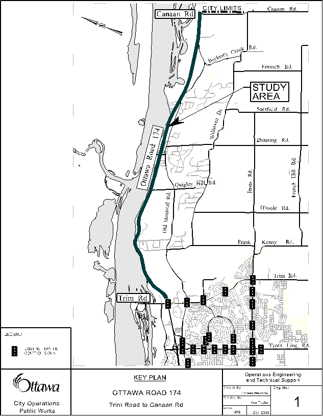
· Install centreline rumble strips: This countermeasure will improve the positive guidance on the road and alert drivers of the presence of no passing zones, as shown in Document 3. The estimated cost of this project is $ 20,000 and funds are available in the Safety Improvement Program account and will be implemented in 2010.
· Increase the pavement width on horizontal curves: The pavement width will be marginally widened on selected horizontal curves west of Quigley Hill Road intersection, as shown in Document 4. It would prevent vehicles off-tracking at horizontal curve locations. The estimated cost of this project is $230,000 and funds are available in Safety Improvement Program account and will be implemented in 2010.
· Conduct a roadside safety design study: The study will identify roadside barriers for replacement as well as potential locations for new installations. It will also determine which ditches along the corridor need improvements. The estimated cost of this study is $75,000 and it has been identified as a project within the Draft 2010 Safety Improvement Program for Council consideration.
·
Improve unsignalized
intersections: The work to upgrade unsignalized
intersections within the corridor has already started at the following
locations:
§ Canaan Road intersection: A new traffic signal was installed at this location in November 2009, as shown in Document 3.
§ Quigley Hill Road intersection: A traffic signal analysis conducted at this intersection concluded that a traffic signal is not warranted at this time. A preliminary design of geometric improvements to provide left turn lanes for this intersection will be done in 2010 and the estimated cost of the design study is $30,000, as shown in Document 4 and funds are available in the Safety Improvement Program account. The funds for the construction of this project will be requested in future capital budgets as a strategic initiative.
· Intersection illumination: Under the City Lighting Policy, this section of roadway warrants only marker lighting at any intersection. Marker lighting consists of only 1 light at a "T" intersection and 2 lights at a four-way intersection. All unsignalized intersections on the corridor only warrant the addition of 1 light. The estimated cost of installing them is approximately $125,000 and it will be implemented between 2010-2011. Funds are available in Safety Improvement Program account.
· Conduct a corridor wide speed zone review: Once all short-term strategies have been implemented, undertake a corridor wide speed zone review to ensure that the appropriate speed limit is in place for this corridor. This will be completed internally by staff and is on the Department’s workplan for 2011.
· Continue the work in education and enforcement: The corridor is identified as a target location through the annual Integrated Road Safety Program campaigns.
· Conduct a speed zone review: In 2010, a speed zone review using the newly approved City of Ottawa Speed Zoning Policy will be conducted within the Cumberland Village.
· Install a traffic camera: A new traffic camera will be installed at Cameron Street to monitor traffic operations and adjust traffic signal timing in real time. The estimated cost of this project is $20,000 and it will be implemented in 2010, as shown in Document 5. Funds are available in Safety Improvement Program account.
Trim Road Intersection Strategy
·
Improve
the intersection geometry and capacity: The Trim Road intersection will
be improved as part of the Trim Road Widening (Ottawa
Road 174 to Frank Kenny). The design
study will be conducted in 2010 and the construction is expected in 2011.
Funding is available for the design study in the 2010 draft capital budget for
council consideration and funds required for the construction will be requested
in the 2011 capital budget as part of the Trim Road Widening (Ottawa Road 174
to Frank Kenny) project in 2011.
·
Relocate the existing transition zone: The
existing transition zone from the freeway section to the two-lane rural
arterial road segment located within a horizontal curve will be
relocated further east of its existing location, as shown in Document 4. The design and construction of this geometric
improvement will be coordinated with improvements planned at the Trim Road
intersection, which is part of the Trim Road Widening (Ottawa Road 174 to Frank
Kenny). The design study will be conducted in 2010 and the funds to construct
the upgraded transition zone from the freeway section to the two-lane rural
arterial road segment in the estimated amount of $4.2 million will be
requested as a part of the Trim Road Widening (Ottawa Road 174 to Frank Kenny)
project in 2011.
· Introduce street lighting: The street
lighting on the approaches to the Trim Road intersection and the upgraded
transition zone will enhance driver awareness of the road changes and reduce
the risk of nighttime collisions. The
implementation of this project will be coordinated with the construction of the
geometric improvements at the Trim Road intersection and the upgrade of the
transition zone in 2011. The funds required in the estimated amount of $1.5
million will be requested in the 2011 capital budget as part of the Trim Road
widening project.
· Introduce speed management strategies: The location of the
existing flashing beacon and signage on the approaches to the Trim Road
intersection will be assessed. As well,
new traffic safety strategies will
be identified as a part of the design study of the geometric improvement at the
Trim Road intersection and the upgraded transition zone. Generally, these strategies are expected to
be low cost and the necessary funds for implementing the strategies will be
requested within the 2011 Safety Improvement Program.
Medium-Term Strategies
Funding Pressures: Currently,
there is no available funding to implement the recommendations listed
below. Staff is recommending that the
City request funds from the provincial and federal governments to assist with
implementing these strategies. Staff
have had very preliminary discussions and upon approval of the report, will
formalize discussions to identify which funding programs may be applicable. A preliminary assessment was conducted to provide
an estimated cost for each recommendation.
A further detailed engineering study would be required to determine the
appropriate combination and simultaneous implementation of these
recommendations.
Corridor-Wide
·
Improve roadside safety: The roadside safety design study will provide the estimated cost of
improving the roadside along the corridor.
This will include installing or upgrading roadside barriers and
improving side ditches. The required
funds to implement the work will be requested in future capital budgets
(between 2011 and 2013) as a strategic initiative.
·
Improve
the intersection geometry at unsignalized intersections: The intersection geometry of unsignalized
intersections can be improved by lengthening existing auxiliary lanes and transition
tapers, and providing left turn lanes.
The design and construction cost, and property acquisition is estimated
at $6.5 million. Further, any future
geometric improvement of unsignalized intersections and roadway accesses should
be staged in two areas, east and west of the Cameron Street intersection.
·
Develop
an access management strategy:
With regards to the accesses, the safety study suggests “in order to preserve
the functionality of this roadway, careful consideration of access management
within this corridor is required”. The
estimated cost of implementing this recommendation is approximately $4.5
million. The Planning and Growth
Management Branch is reviewing the access management issues and the
recommendations provided in the safety study. Further, TMP (6.4)
Road Design section recommends against permitting “new
accesses to Highway 174 east of Trim Road, despite that road’s arterial road
classification, to preserve a safe travel environment in view of its high
traffic speeds and volumes”.
·
Upgrade pavement width: Existing roadway
surface (pavement) on the corridor is in good condition. A new assessment will be conducted in future
years and the width of the pavement will be slightly widened to prevent
vehicles off-tracking on the road.
Cameron Street Intersection
and Cumberland Community Strategy
· Improve the intersection geometry and capacity at Cameron Street intersection: A traffic capacity study would be required to carry forward a full assessment of the delay benefit and/or compromises derived from improving the intersection capacity at the Cameron Street intersection. As well, the design of the intersection geometry improvement should be extended to consider speed management strategies on the approaches to the intersection and through the Cumberland Village and include pedestrian and cycling traffic. The design and construction cost, and property acquisition of this project is estimated at $7 million. The recommendation was forwarded to the Planning and Growth Management Branch for review and will be seeking funding for this project in future years.
Corridor
Operation Improvements
In addition, preliminary analysis was conducted for
each of two candidate corridor-wide operational strategies; four-laning OR 174
from east of Trim Road to Canaan Road (City limits) and introducing passing
lanes. The results of the preliminary
analysis suggest that neither of these strategies can be justified based solely
on safety factors. Although the
analysis shows that these measures would reduce vehicular delays, from a
traffic safety perspective, the benefit to the corridor is not as clear.
A traffic capacity study would be required to carry
forward a full assessment of the delay benefit and/or compromises derived from
the four-laning or introduction of passing lanes and alternative scenarios to
achieve corridor-wide operational improvements.
This task was not within the scope of the safety study. It should be noted that the Transportation
Master Plan (TMP), which was approved by City Council in 2008, does not include
the four-laning of OR 174 east of Trim Road.
Based
on the results of the preliminary traffic safety analysis of the Corridor
Operation Improvements noted above, only those strategies included in the road
safety implementation plan (Table 2) should be considered at this time.
CITY STRATEGIC DIRECTIONS
The safety recommendations included in this
report are consistent with the Service Priorities for the City Strategic Plan
2007 – 2010, specifically the following:
§ Transportation Priority, Objective 1 - Continue to undertake Road Safety Audits along major corridors in order to address traffic safety issues.
The principles of the Ottawa 20/20
Transportation Master Plan (TMP), Section 6.5 Road Safety, approved by Council
at its meeting November 28, 2008, are reflected in the safety strategies
recommended in this report.
RURAL IMPLICATIONS
Ottawa
Road 174 east of Trim Road intersection up to the City limits east of the
Canaan Road intersection is an arterial rural road. By implementing the recommendations provided
in the report, the traffic safety conditions along this corridor are expected
to improve.
CONSULTATION
The Ward Councillors
have been briefed and concur on the findings of the road safety study and the
implementation plan set out in this report.
Infrastructure Services and Community
Sustainability Department staff was consulted regarding this report.
LEGAL/RISK MANAGEMENT IMPLICATIONS
FINANCIAL IMPLICATIONS
Funds are available in the 2009 and prior year
approved capital budgets to fund the following short-term strategies;
·
Construction of centre line
rumble strips - $20K;
·
The pavement width improvement
on selected horizontal curves west of Quigley Hill Road - $230K;
·
The preliminary design of geometric improvements at
Quigley Hill Road - $30K;
·
The installation of a new
camera at Cameron Street intersection - $20K;
·
The installation of marker
lighting at unsignalized intersections within the corridor – $125K.
Funding requests have been made in the Draft 2010 capital budget for the following short-term strategies;
·
Signage and pavement marking
upgrades - $100K;
·
Roadside safety design study -
$75K.
Future capital requests will be made as per the recommendations contained in this report.
SUPPORTING DOCUMENTATION
Document 1 - Key Plan - Ottawa Road 174 from Trim Road to
Canaan Road (City limits) Study Area (Immediately following the report)
Document 2 - Collision Summary - Ottawa Road 174 from Trim
Road to Canaan Road (City limits) (Immediately
following the report)
Document 3 - Key Plan of Locations of the Centreline Rumble
Strips - Ottawa Road 174 from Trim Road to Canaan Road (City limits) (Immediately following the report)
Document 4 - Key Plan of Improvement on Horizontal Curves
and Intersection Improvement - Ottawa
Road 174 from Trim Road to Quigley Hill Road (Immediately following the report)
Document 5 - Key Plan of Cumberland Village and Cameron
Street intersection (Immediately
following the report)
DISPOSITION
Following Council approval, the Department of Public Works will
implement the recommendations identified in this report.
DOCUMENT 1
OR 174 (Trim Road –
Canaan Road)
|
Ottawa's Collision Summary |
|||||||
|
Location: |
|
OR
174 From Trim Road to Canaan Road (City Boundary) |
|
|
|||
|
Time
Period Covered: |
01/01/2003
- 31/12/2007 |
|
|
|
|
||
|
Total
of Collisions: |
270
collisions |
|
|
|
|
|
|
|
Remarks: |
|
All
Collisions (Two-Lane, Two-Way Road) |
|
|
|
||
|
|
|
|
|
|
|
|
|
|
Location |
At/From |
To |
Total |
Non-fatal injury |
Fatal Collisions |
PDO |
|
|
Signalized
intersection |
OR 174 |
TRIM RD |
|
57 |
10 |
|
47 |
|
|
OR 174 EB |
510 E OF TRIM RD |
TRIM RD |
14 |
4 |
|
10 |
|
Mainline
Segment |
OR 174 WB |
510 E OF TRIM RD |
TRIM RD |
5 |
1 |
|
4 |
|
|
OR 174 |
510 E OF TRIM RD |
QUIGLEY HILL RD |
44 |
7 |
2 |
35 |
|
Unsignalized
intersection |
OR 174 |
QUIGLEY HILL RD |
|
3 |
1 |
|
2 |
|
Mainline
Segment |
OR 174 |
CAMERON ST |
QUIGLEY HILL RD |
31 |
7 |
1 |
23 |
|
Signalized
intersection |
OR 174 |
CAMERON ST |
|
21 |
4 |
|
17 |
|
Mainline
Segment |
OR 174 |
CAMERON ST |
WEST ST |
3 |
0 |
|
3 |
|
Unsignalized
intersection |
OR 174 |
WEST ST |
|
1 |
0 |
|
1 |
|
Mainline
Segment |
OR 174 |
FAUBERT ST |
WEST ST |
8 |
1 |
|
7 |
|
Unsignalized
intersection |
OR 174 |
FAUBERT ST |
|
4 |
2 |
|
2 |
|
Mainline
Segment |
OR 174 |
EAST ST |
FAUBERT ST |
5 |
2 |
|
3 |
|
Unsignalized
intersection |
OR 174 |
EAST ST / PETER HARKNESS LANE |
|
2 |
0 |
|
2 |
|
Mainline
Segment |
OR 174 |
EAST SHORE RD |
EAST ST |
14 |
3 |
|
11 |
|
Unsignalized
intersection |
OR 174 |
EAST SHORE RD |
|
2 |
1 |
|
1 |
|
Mainline
Segment |
OR 174 |
EAST SHORE RD |
MORIN RD |
3 |
0 |
|
3 |
|
Unsignalized
intersection |
OR 174 |
MORIN RD |
|
0 |
0 |
|
0 |
|
Mainline
Segment |
OR 174 |
MORIN RD |
OLD MONTREAL RD |
11 |
1 |
|
10 |
|
Unsignalized
intersection |
OR 174 |
OLD MONTREAL RD W
(Kinsella Dr) |
|
1 |
0 |
1 |
0 |
|
Mainline
Segment |
OR 174 |
OLD MONTREAL RD W |
OLD MONTREAL RD E |
22 |
4 |
|
18 |
|
Unsignalized
intersection |
OR 174 |
OLD MONTREAL RD E |
|
4 |
2 |
|
2 |
|
Mainline
Segment |
OR 174 |
OLD MONTREAL RD |
MCTEER RD |
5 |
1 |
|
4 |
|
Unsignalized
intersection |
OR 174 |
CANAAN RD |
|
1 |
0 |
|
1 |
|
Mainline
Segment |
OR 174 |
CANAAN RD |
MCTEER RD |
8 |
1 |
1 |
6 |
|
|
OR 174 |
CANAAN RD |
CITY BOUNDARY |
1 |
0 |
|
1 |
|
|
TOTALS |
270 |
52 |
5 |
213 |
||
DOCUMENT 3
DOCUMENT 4